Narrow Results By
Deer Lake
https://search.heritageburnaby.ca/link/archivedescription37948
- Repository
- City of Burnaby Archives
- Date
- 1943 (date of original), copied 1991
- Collection/Fonds
- Burnaby Historical Society fonds
- Description Level
- Item
- Physical Description
- 1 photograph : b&w ; 4.1 x 2.8 cm print on contact sheet 20.6 x 26.1 cm
- Scope and Content
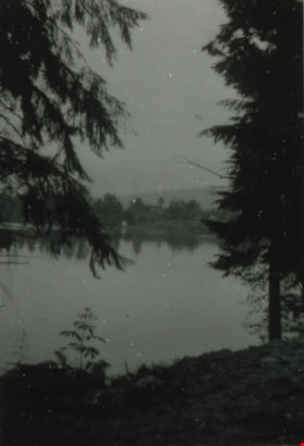
- Photograph of Deer Lake.
- Repository
- City of Burnaby Archives
- Date
- 1943 (date of original), copied 1991
- Collection/Fonds
- Burnaby Historical Society fonds
- Subseries
- Burnaby Image Bank subseries
- Physical Description
- 1 photograph : b&w ; 4.1 x 2.8 cm print on contact sheet 20.6 x 26.1 cm
- Description Level
- Item
- Record No.
- 370-535
- Access Restriction
- No restrictions
- Reproduction Restriction
- No known restrictions
- Accession Number
- BHS1999-03
- Scope and Content
- Photograph of Deer Lake.
- Media Type
- Photograph
- Notes
- Title based on contents of photograph
- 1 b&w copy negative accompanying
- Geographic Access
- Deer Lake
- Historic Neighbourhood
- Burnaby Lake (Historic Neighbourhood)
- Planning Study Area
- Oakalla Area
Images
![Deer Lake, [1947 or 1948] (date of original), copied 1991 thumbnail](/media/hpo/_Data/_Archives_Images/_Unrestricted/370/370-564.jpg?width=280)
Deer Lake
https://search.heritageburnaby.ca/link/archivedescription37977
- Repository
- City of Burnaby Archives
- Date
- [1947 or 1948] (date of original), copied 1991
- Collection/Fonds
- Burnaby Historical Society fonds
- Description Level
- Item
- Physical Description
- 1 photograph : b&w ; 2.8 x 4.8 cm print on contact sheet 20.7 x 26.2 cm
- Scope and Content
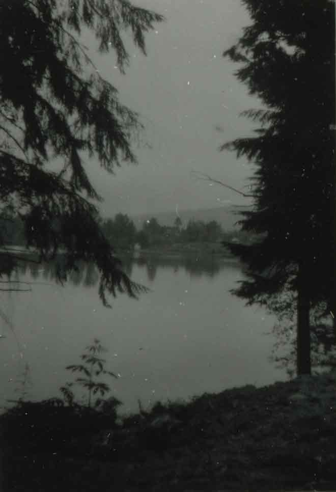
- Photograph of Deer Lake.
- Repository
- City of Burnaby Archives
- Date
- [1947 or 1948] (date of original), copied 1991
- Collection/Fonds
- Burnaby Historical Society fonds
- Subseries
- Burnaby Image Bank subseries
- Physical Description
- 1 photograph : b&w ; 2.8 x 4.8 cm print on contact sheet 20.7 x 26.2 cm
- Description Level
- Item
- Record No.
- 370-564
- Access Restriction
- No restrictions
- Reproduction Restriction
- No known restrictions
- Accession Number
- BHS1999-03
- Scope and Content
- Photograph of Deer Lake.
- Media Type
- Photograph
- Notes
- Title based on contents of photograph
- 1 b&w copy negative accompanying
- Geographic Access
- Deer Lake
- Historic Neighbourhood
- Burnaby Lake (Historic Neighbourhood)
- Planning Study Area
- Oakalla Area
Images
![Deer Lake, [1947 or 1948] (date of original), copied 1991 thumbnail](/media/hpo/_Data/_Archives_Images/_Unrestricted/370/370-564.jpg)
![Deer Lake and Sperling Avenue, [1946] (date of original), copied 1991 thumbnail](/media/hpo/_Data/_Archives_Images/_Unrestricted/370/370-533.jpg?width=280)
Deer Lake and Sperling Avenue
https://search.heritageburnaby.ca/link/archivedescription37946
- Repository
- City of Burnaby Archives
- Date
- [1946] (date of original), copied 1991
- Collection/Fonds
- Burnaby Historical Society fonds
- Description Level
- Item
- Physical Description
- 1 photograph : b&w ; 3.5 x 4.4 cm print on contact sheet 20.5 x 26.7 cm
- Scope and Content
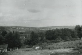
- Aerial photograph of Deer Lake and the Sperling Avenue area facing north.
- Repository
- City of Burnaby Archives
- Date
- [1946] (date of original), copied 1991
- Collection/Fonds
- Burnaby Historical Society fonds
- Subseries
- Burnaby Image Bank subseries
- Physical Description
- 1 photograph : b&w ; 3.5 x 4.4 cm print on contact sheet 20.5 x 26.7 cm
- Description Level
- Item
- Record No.
- 370-533
- Access Restriction
- No restrictions
- Reproduction Restriction
- No known restrictions
- Accession Number
- BHS1999-03
- Scope and Content
- Aerial photograph of Deer Lake and the Sperling Avenue area facing north.
- Media Type
- Photograph
- Notes
- Title based on contents of photograph
- 1 b&w copy negative accompanying
- Negative has a pink cast
- Geographic Access
- Deer Lake
- Sperling Avenue
- Historic Neighbourhood
- Burnaby Lake (Historic Neighbourhood)
- Planning Study Area
- Morley-Buckingham Area
Images
![Deer Lake and Sperling Avenue, [1946] (date of original), copied 1991 thumbnail](/media/hpo/_Data/_Archives_Images/_Unrestricted/370/370-533.jpg)
![Deer Lake United Church, [1941] (date of original), copied 1991 thumbnail](/media/hpo/_Data/_Archives_Images/_Unrestricted/370/370-545.jpg?width=280)
Deer Lake United Church
https://search.heritageburnaby.ca/link/archivedescription37958
- Repository
- City of Burnaby Archives
- Date
- [1941] (date of original), copied 1991
- Collection/Fonds
- Burnaby Historical Society fonds
- Description Level
- Item
- Physical Description
- 1 photograph : b&w ; 2.6 x 3.7 cm print on contact sheet 20.6 x 26.1 cm
- Scope and Content
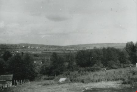
- Photograph of Deer Lake United Church and the foundation of Graham Dent's house, 4000 Block Sperling Avenue (later renumbered as the 5100 block of Sperling Avenue).
- Repository
- City of Burnaby Archives
- Date
- [1941] (date of original), copied 1991
- Collection/Fonds
- Burnaby Historical Society fonds
- Subseries
- Burnaby Image Bank subseries
- Physical Description
- 1 photograph : b&w ; 2.6 x 3.7 cm print on contact sheet 20.6 x 26.1 cm
- Description Level
- Item
- Record No.
- 370-545
- Access Restriction
- No restrictions
- Reproduction Restriction
- No known restrictions
- Accession Number
- BHS1999-03
- Scope and Content
- Photograph of Deer Lake United Church and the foundation of Graham Dent's house, 4000 Block Sperling Avenue (later renumbered as the 5100 block of Sperling Avenue).
- Names
- Deer Lake United Church
- Media Type
- Photograph
- Notes
- Title based on contents of photograph
- 1 b&w copy negative accompanying
- Geographic Access
- Sperling Avenue
- Street Address
- 5135 Sperling Avenue
- Historic Neighbourhood
- Burnaby Lake (Historic Neighbourhood)
- Planning Study Area
- Morley-Buckingham Area
Images
![Deer Lake United Church, [1941] (date of original), copied 1991 thumbnail](/media/hpo/_Data/_Archives_Images/_Unrestricted/370/370-545.jpg)
![Dent family house, [1941] (date of original), copied 1991 thumbnail](/media/hpo/_Data/_Archives_Images/_Unrestricted/370/370-549.jpg?width=280)
Dent family house
https://search.heritageburnaby.ca/link/archivedescription37962
- Repository
- City of Burnaby Archives
- Date
- [1941] (date of original), copied 1991
- Collection/Fonds
- Burnaby Historical Society fonds
- Description Level
- Item
- Physical Description
- 1 photograph : b&w ; 2.6 x 3.5 cm print on contact sheet 20.7 x 26.2 cm
- Scope and Content
- Photograph of the house belonging to the Dent family, completed ca. 1941.
- Repository
- City of Burnaby Archives
- Date
- [1941] (date of original), copied 1991
- Collection/Fonds
- Burnaby Historical Society fonds
- Subseries
- Burnaby Image Bank subseries
- Physical Description
- 1 photograph : b&w ; 2.6 x 3.5 cm print on contact sheet 20.7 x 26.2 cm
- Description Level
- Item
- Record No.
- 370-549
- Access Restriction
- No restrictions
- Reproduction Restriction
- No known restrictions
- Accession Number
- BHS1999-03
- Scope and Content
- Photograph of the house belonging to the Dent family, completed ca. 1941.
- Subjects
- Buildings - Residential - Houses
- Media Type
- Photograph
- Notes
- Title based on contents of photograph
- 1 b&w copy negative accompanying
- Geographic Access
- Sperling Avenue
- Historic Neighbourhood
- Burnaby Lake (Historic Neighbourhood)
- Planning Study Area
- Morley-Buckingham Area
Images
![Dent family house, [1941] (date of original), copied 1991 thumbnail](/media/hpo/_Data/_Archives_Images/_Unrestricted/370/370-549.jpg)
![Dent family house, [1941 or 1942] (date of original), copied 1991 thumbnail](/media/hpo/_Data/_Archives_Images/_Unrestricted/370/370-553.jpg?width=280)
Dent family house
https://search.heritageburnaby.ca/link/archivedescription37966
- Repository
- City of Burnaby Archives
- Date
- [1941 or 1942] (date of original), copied 1991
- Collection/Fonds
- Burnaby Historical Society fonds
- Description Level
- Item
- Physical Description
- 1 photograph : b&w ; 2.3 x 3.1 cm print on contact sheet 20.7 x 26.2 cm
- Scope and Content
- Photograph of the Dent family house on the 5100 block of Sperling Ave.
- Repository
- City of Burnaby Archives
- Date
- [1941 or 1942] (date of original), copied 1991
- Collection/Fonds
- Burnaby Historical Society fonds
- Subseries
- Burnaby Image Bank subseries
- Physical Description
- 1 photograph : b&w ; 2.3 x 3.1 cm print on contact sheet 20.7 x 26.2 cm
- Description Level
- Item
- Record No.
- 370-553
- Access Restriction
- No restrictions
- Reproduction Restriction
- No known restrictions
- Accession Number
- BHS1999-03
- Scope and Content
- Photograph of the Dent family house on the 5100 block of Sperling Ave.
- Subjects
- Buildings - Residential - Houses
- Media Type
- Photograph
- Notes
- Title based on contents of photograph
- 1 b&w copy negative accompanying
- Geographic Access
- Sperling Avenue
- Historic Neighbourhood
- Burnaby Lake (Historic Neighbourhood)
- Planning Study Area
- Morley-Buckingham Area
Images
![Dent family house, [1941 or 1942] (date of original), copied 1991 thumbnail](/media/hpo/_Data/_Archives_Images/_Unrestricted/370/370-553.jpg)
![Desmond Barrett, [1947] (date of original), copied 1991 thumbnail](/media/hpo/_Data/_Archives_Images/_Unrestricted/370/370-558.jpg?width=280)
Desmond Barrett
https://search.heritageburnaby.ca/link/archivedescription37971
- Repository
- City of Burnaby Archives
- Date
- [1947] (date of original), copied 1991
- Collection/Fonds
- Burnaby Historical Society fonds
- Description Level
- Item
- Physical Description
- 1 photograph : b&w ; 3.9 x 2.6 cm print on contact sheet 20.7 x 26.2 cm
- Scope and Content
- Photograph of Desmond Barrett skating on Deer Lake.
- Repository
- City of Burnaby Archives
- Date
- [1947] (date of original), copied 1991
- Collection/Fonds
- Burnaby Historical Society fonds
- Subseries
- Burnaby Image Bank subseries
- Physical Description
- 1 photograph : b&w ; 3.9 x 2.6 cm print on contact sheet 20.7 x 26.2 cm
- Description Level
- Item
- Record No.
- 370-558
- Access Restriction
- No restrictions
- Reproduction Restriction
- No known restrictions
- Accession Number
- BHS1999-03
- Scope and Content
- Photograph of Desmond Barrett skating on Deer Lake.
- Names
- Barrett, Desmond
- Media Type
- Photograph
- Notes
- Title based on contents of photograph
- 2 b&w copy prints accompanying
- 1 b&w copy negative accompanying
- Geographic Access
- Deer Lake
- Historic Neighbourhood
- Burnaby Lake (Historic Neighbourhood)
- Planning Study Area
- Oakalla Area
Images
![Desmond Barrett, [1947] (date of original), copied 1991 thumbnail](/media/hpo/_Data/_Archives_Images/_Unrestricted/370/370-558.jpg)
![Devereux and Pontifex families, [1948] (date of original), copied 1991 thumbnail](/media/hpo/_Data/_Archives_Images/_Unrestricted/370/370-514.jpg?width=280)
Devereux and Pontifex families
https://search.heritageburnaby.ca/link/archivedescription37926
- Repository
- City of Burnaby Archives
- Date
- [1948] (date of original), copied 1991
- Collection/Fonds
- Burnaby Historical Society fonds
- Description Level
- Item
- Physical Description
- 1 photograph : b&w ; 2.8 x 4.3 cm print on contact sheet 20.7 x 26.5 cm
- Scope and Content
- Photograph of (left to right) Wally Devereux, Audrey Devereux, Bob Pontifex and Basil Pontifex, at the back of 4006 Douglas Road (old numbering) and Gilpin Street.
- Repository
- City of Burnaby Archives
- Date
- [1948] (date of original), copied 1991
- Collection/Fonds
- Burnaby Historical Society fonds
- Subseries
- Burnaby Image Bank subseries
- Physical Description
- 1 photograph : b&w ; 2.8 x 4.3 cm print on contact sheet 20.7 x 26.5 cm
- Description Level
- Item
- Record No.
- 370-514
- Access Restriction
- No restrictions
- Reproduction Restriction
- No known restrictions
- Accession Number
- BHS1999-03
- Scope and Content
- Photograph of (left to right) Wally Devereux, Audrey Devereux, Bob Pontifex and Basil Pontifex, at the back of 4006 Douglas Road (old numbering) and Gilpin Street.
- Media Type
- Photograph
- Notes
- Title based on contents of photograph
- 1 b&w copy negative accompanying
- Negative has a pink cast
- Geographic Access
- Gilpin Street
- Historic Neighbourhood
- Burnaby Lake (Historic Neighbourhood)
- Planning Study Area
- Douglas-Gilpin Area
Images
![Devereux and Pontifex families, [1948] (date of original), copied 1991 thumbnail](/media/hpo/_Data/_Archives_Images/_Unrestricted/370/370-514.jpg)
![Douglas Road School students, [between 1940 and 1942] thumbnail](/media/hpo/_Data/_BVM_Images/2017/201700280031_001.jpg?width=280)
Douglas Road School students
https://search.heritageburnaby.ca/link/museumdescription4234
- Repository
- Burnaby Village Museum
- Date
- [between 1940 and 1942]
- Collection/Fonds
- Burnaby Village Museum Photograph collection
- Description Level
- Item
- Physical Description
- 1 photograph : b&w ; 13 x 18 cm
- Scope and Content
- Photograph of students from Douglas Road School, possibly grade seven or eight class. Students and a male teacher are standing and sitting in front of a outside wooden staircase. There are 10 female students and 11 male students. Glen Boal is seated in the front row, third from the right.
- Repository
- Burnaby Village Museum
- Collection/Fonds
- Burnaby Village Museum Photograph collection
- Description Level
- Item
- Physical Description
- 1 photograph : b&w ; 13 x 18 cm
- Material Details
- Handwritten text on back of photograph reads: 'Glen Boal seated front row / 3d from right".
- Scope and Content
- Photograph of students from Douglas Road School, possibly grade seven or eight class. Students and a male teacher are standing and sitting in front of a outside wooden staircase. There are 10 female students and 11 male students. Glen Boal is seated in the front row, third from the right.
- Subjects
- Persons - Students
- Geographic Access
- Canada Way
- Street Address
- 4861 Canada Way
- Accession Code
- BV017.28.31
- Access Restriction
- No restrictions
- Reproduction Restriction
- No known restrictions
- Date
- [between 1940 and 1942]
- Media Type
- Photograph
- Historic Neighbourhood
- Burnaby Lake (Historic Neighbourhood)
- Planning Study Area
- Douglas-Gilpin Area
- Scan Resolution
- 600
- Scan Date
- 06-Mar-2018
- Notes
- Title based on contents of photograph
Images
![Douglas Road School students, [between 1940 and 1942] thumbnail](/media/hpo/_Data/_BVM_Images/2017/201700280031_001.jpg)
![Douglas Road School students, [between 1938 and 1940] thumbnail](/media/hpo/_Data/_BVM_Images/2017/201700280032_001.jpg?width=280)
Douglas Road School students
https://search.heritageburnaby.ca/link/museumdescription4235
- Repository
- Burnaby Village Museum
- Date
- [between 1938 and 1940]
- Collection/Fonds
- Burnaby Village Museum Photograph collection
- Description Level
- Item
- Physical Description
- 1 photograph : b&w ; 13 x 18 cm
- Scope and Content
- Photograph of students from Douglas Road School, elementary grade. This is possibly a combined class as there are two teachers in the photo and 51 students. The students are in four rows with a male teacher at either end of the third row. Glen Boal is at the left end of the third row standing next …
- Repository
- Burnaby Village Museum
- Collection/Fonds
- Burnaby Village Museum Photograph collection
- Description Level
- Item
- Physical Description
- 1 photograph : b&w ; 13 x 18 cm
- Material Details
- Handwritten text on back of photograph reads: 'Glen Boal / 3d Row far left beside teacher".
- Scope and Content
- Photograph of students from Douglas Road School, elementary grade. This is possibly a combined class as there are two teachers in the photo and 51 students. The students are in four rows with a male teacher at either end of the third row. Glen Boal is at the left end of the third row standing next to a teacher.
- Subjects
- Persons - Students
- Geographic Access
- Canada Way
- Street Address
- 4861 Canada Way
- Accession Code
- BV017.28.32
- Access Restriction
- No restrictions
- Reproduction Restriction
- No known restrictions
- Date
- [between 1938 and 1940]
- Media Type
- Photograph
- Historic Neighbourhood
- Burnaby Lake (Historic Neighbourhood)
- Planning Study Area
- Douglas-Gilpin Area
- Scan Resolution
- 600
- Scan Date
- 06-Mar-2018
- Notes
- Title based on contents of photograph
Images
![Douglas Road School students, [between 1938 and 1940] thumbnail](/media/hpo/_Data/_BVM_Images/2017/201700280032_001.jpg)

Do Your Part Eagle
https://search.heritageburnaby.ca/link/archivedescription95084
- Repository
- City of Burnaby Archives
- Date
- June 13, 2020
- Collection/Fonds
- Burnaby Photographic Society fonds
- Description Level
- Item
- Physical Description
- 1 photograph (tiff)
- Scope and Content
- Photograph of a sign along the Burnaby Lake Freeway Trail that reads: "Do your part. Stay 2 metres apart." The sign has a silhoutte drawing of an eagle with its wings open to illustrate the distance of two metres.
- Repository
- City of Burnaby Archives
- Date
- June 13, 2020
- Collection/Fonds
- Burnaby Photographic Society fonds
- Physical Description
- 1 photograph (tiff)
- Description Level
- Item
- Record No.
- 623-003
- Access Restriction
- No restrictions
- Reproduction Restriction
- No restrictions
- Accession Number
- 2020-10
- Scope and Content
- Photograph of a sign along the Burnaby Lake Freeway Trail that reads: "Do your part. Stay 2 metres apart." The sign has a silhoutte drawing of an eagle with its wings open to illustrate the distance of two metres.
- Media Type
- Photograph
- Photographer
- Gervan, Bonnie
- Notes
- Transcribed title
- Photographer's caption: "A sign shows how far to keep apart."
- Geographic Access
- Burnaby Lake Regional Nature Park
- Historic Neighbourhood
- Burnaby Lake (Historic Neighbourhood)
- Planning Study Area
- Burnaby Lake Area
Images

East from Norland Avenue
https://search.heritageburnaby.ca/link/archivedescription37433
- Repository
- City of Burnaby Archives
- Date
- 1949 (date of original), copied 1991
- Collection/Fonds
- Burnaby Historical Society fonds
- Description Level
- Item
- Physical Description
- 1 photograph : b&w ; 2.2 x 4.0 cm print on contact sheet 20.2 x 25.3 cm
- Scope and Content
- Photograph from the back of 4437 Norland Avenue (later renumber 3908 Norland Avenue), facing east. This photograph was taken before the Trans Canada Highway was built.
- Repository
- City of Burnaby Archives
- Date
- 1949 (date of original), copied 1991
- Collection/Fonds
- Burnaby Historical Society fonds
- Subseries
- Burnaby Image Bank subseries
- Physical Description
- 1 photograph : b&w ; 2.2 x 4.0 cm print on contact sheet 20.2 x 25.3 cm
- Description Level
- Item
- Record No.
- 370-021
- Access Restriction
- No restrictions
- Reproduction Restriction
- No restrictions
- Accession Number
- BHS1999-03
- Scope and Content
- Photograph from the back of 4437 Norland Avenue (later renumber 3908 Norland Avenue), facing east. This photograph was taken before the Trans Canada Highway was built.
- Media Type
- Photograph
- Notes
- Title based on contents of photograph
- 1 b&w copy negative accompanying
- Geographic Access
- Norland Avenue
- Street Address
- 3908 Norland Avenue
- Historic Neighbourhood
- Burnaby Lake (Historic Neighbourhood)
- Planning Study Area
- Douglas-Gilpin Area
Images
![Edie and Maureen Fleming, [ca. 1940s] thumbnail](/media/Hpo/_Data/_BVM_Images/2016/2016_0046_0106_001.jpg?width=280)
Edie and Maureen Fleming
https://search.heritageburnaby.ca/link/museumdescription5151
- Repository
- Burnaby Village Museum
- Date
- [ca. 1940s]
- Collection/Fonds
- Waplington family fonds
- Description Level
- Item
- Physical Description
- 1 photograph : b&w ; 8.5 x 6 cm
- Scope and Content
- Photograph of Edith (Edie) and Maureen Fleming hugging near a tree in the yard of the Waplington/Fleming home located at 3813 Deer Lake Avenue.
- Repository
- Burnaby Village Museum
- Collection/Fonds
- Waplington family fonds
- Description Level
- Item
- Physical Description
- 1 photograph : b&w ; 8.5 x 6 cm
- Scope and Content
- Photograph of Edith (Edie) and Maureen Fleming hugging near a tree in the yard of the Waplington/Fleming home located at 3813 Deer Lake Avenue.
- Geographic Access
- Deer Lake Avenue
- Street Address
- 3813 Deer Lake Avenue
- Accession Code
- BV016.46.106
- Access Restriction
- No restrictions
- Reproduction Restriction
- No known restrictions
- Date
- [ca. 1940s]
- Media Type
- Photograph
- Historic Neighbourhood
- Burnaby Lake (Historic Neighbourhood)
- Planning Study Area
- Morley-Buckingham Area
- Scan Resolution
- 600
- Scan Date
- 13-Aug-2018
- Notes
- Title based on information from photograph album
- Photograph is part of Photograph album BV016.46.52
Images
![Edie and Maureen Fleming, [ca. 1940s] thumbnail](/media/Hpo/_Data/_BVM_Images/2016/2016_0046_0106_001.jpg)
![Edie Fleming, [ca. 1940s] thumbnail](/media/Hpo/_Data/_BVM_Images/2016/2016_0046_0107_001.jpg?width=280)
Edie Fleming
https://search.heritageburnaby.ca/link/museumdescription5152
- Repository
- Burnaby Village Museum
- Date
- [ca. 1940s]
- Collection/Fonds
- Waplington family fonds
- Description Level
- Item
- Physical Description
- 1 photograph : b&w ; 8.5 x 6 cm
- Scope and Content
- Photograph of Edith (Edie) in the yard of the Waplington/Fleming home located at 3813 Deer Lake Avenue. Edith is wearing overalls and has one hand in her pocket.
- Repository
- Burnaby Village Museum
- Collection/Fonds
- Waplington family fonds
- Description Level
- Item
- Physical Description
- 1 photograph : b&w ; 8.5 x 6 cm
- Scope and Content
- Photograph of Edith (Edie) in the yard of the Waplington/Fleming home located at 3813 Deer Lake Avenue. Edith is wearing overalls and has one hand in her pocket.
- Geographic Access
- Deer Lake Avenue
- Street Address
- 3813 Deer Lake Avenue
- Accession Code
- BV016.46.107
- Access Restriction
- No restrictions
- Reproduction Restriction
- No known restrictions
- Date
- [ca. 1940s]
- Media Type
- Photograph
- Historic Neighbourhood
- Burnaby Lake (Historic Neighbourhood)
- Planning Study Area
- Morley-Buckingham Area
- Scan Resolution
- 600
- Scan Date
- 13-Aug-2018
- Notes
- Title based on information from photograph album
- Photograph is part of Photograph album BV016.46.52
Images
![Edie Fleming, [ca. 1940s] thumbnail](/media/Hpo/_Data/_BVM_Images/2016/2016_0046_0107_001.jpg)
Edie Fleming
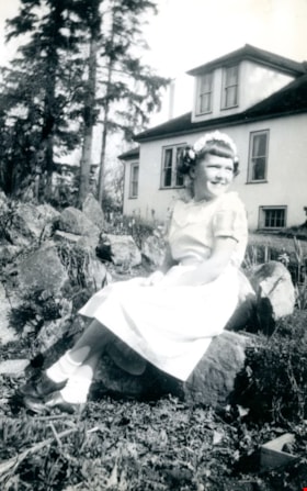
https://search.heritageburnaby.ca/link/museumdescription5154
- Repository
- Burnaby Village Museum
- Date
- 1949
- Collection/Fonds
- Waplington family fonds
- Description Level
- Item
- Physical Description
- 1 photograph : b&w ; 21 x 8 cm
- Scope and Content
- Photograph of Edith (Edie) Fleming seated on a rock outside the Waplington/Fleming home located at 3813 Deer Lake Avenue. Edith is dressed in white with a floral crown for church on Easter Sunday.
- Repository
- Burnaby Village Museum
- Collection/Fonds
- Waplington family fonds
- Description Level
- Item
- Physical Description
- 1 photograph : b&w ; 21 x 8 cm
- Scope and Content
- Photograph of Edith (Edie) Fleming seated on a rock outside the Waplington/Fleming home located at 3813 Deer Lake Avenue. Edith is dressed in white with a floral crown for church on Easter Sunday.
- Subjects
- Holidays - Easter
- Geographic Access
- Deer Lake Avenue
- Street Address
- 3813 Deer Lake Avenue
- Accession Code
- BV016.46.109
- Access Restriction
- No restrictions
- Reproduction Restriction
- No known restrictions
- Date
- 1949
- Media Type
- Photograph
- Historic Neighbourhood
- Burnaby Lake (Historic Neighbourhood)
- Planning Study Area
- Morley-Buckingham Area
- Scan Resolution
- 600
- Scan Date
- 13-Aug-2018
- Notes
- Title based on information from photograph album
- Note in black ink on verso of photograph reads: "Taken by Ray / Edith / Easter 1949"
- Photograph is part of Photograph album BV016.46.52
Images

Essential Workers’ Tribute
https://search.heritageburnaby.ca/link/archivedescription95129
- Repository
- City of Burnaby Archives
- Date
- April 27, 2020
- Collection/Fonds
- Burnaby Photographic Society fonds
- Description Level
- Item
- Physical Description
- 1 photograph (tiff)
- Scope and Content
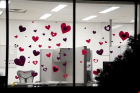
- Photograph of a window of the Burnaby RCMP Detachment decorated with red and purple paper hearts. The photograph was taken at night, illuminating the office inside.
- Repository
- City of Burnaby Archives
- Date
- April 27, 2020
- Collection/Fonds
- Burnaby Photographic Society fonds
- Physical Description
- 1 photograph (tiff)
- Description Level
- Item
- Record No.
- 623-047
- Access Restriction
- No restrictions
- Reproduction Restriction
- Reproduce for fair dealing purposes only
- Accession Number
- 2020-10
- Scope and Content
- Photograph of a window of the Burnaby RCMP Detachment decorated with red and purple paper hearts. The photograph was taken at night, illuminating the office inside.
- Subjects
- Buildings - Commercial - Offices
- Media Type
- Photograph
- Photographer
- Jerome, Ron
- Notes
- Transcribed title
- Geographic Access
- Deer Lake Avenue
- Street Address
- 6335 Deer Lake Avenue
- Historic Neighbourhood
- Burnaby Lake (Historic Neighbourhood)
- Planning Study Area
- Douglas-Gilpin Area
Images

![Fairacres front walk, [between 1939 and 1954] thumbnail](/media/hpo/_Data/_Archives_Images/_Unrestricted/205/242-003.jpg?width=280)
Fairacres front walk
https://search.heritageburnaby.ca/link/archivedescription36253
- Repository
- City of Burnaby Archives
- Date
- [between 1939 and 1954]
- Collection/Fonds
- Burnaby Historical Society fonds
- Description Level
- Item
- Physical Description
- 1 photograph : b&w copy negative ; 3.5 x 5 cm
- Scope and Content
- Photograph of the front walk at the Ceperley Mansion, (Fairacres). The Order of St. Benedict purchased and occupied it from 1939 to 1954. The roadway is paved and the walkway is made of paving stones.
- Repository
- City of Burnaby Archives
- Date
- [between 1939 and 1954]
- Collection/Fonds
- Burnaby Historical Society fonds
- Subseries
- Burnaby Art Gallery subseries
- Physical Description
- 1 photograph : b&w copy negative ; 3.5 x 5 cm
- Description Level
- Item
- Record No.
- 242-003
- Access Restriction
- No restrictions
- Reproduction Restriction
- No known restrictions
- Accession Number
- BHS1990-05
- Scope and Content
- Photograph of the front walk at the Ceperley Mansion, (Fairacres). The Order of St. Benedict purchased and occupied it from 1939 to 1954. The roadway is paved and the walkway is made of paving stones.
- Media Type
- Photograph
- Notes
- Title based on contents of photograph
- Geographic Access
- Deer Lake Avenue
- Street Address
- 6344 Deer Lake Avenue
- Historic Neighbourhood
- Burnaby Lake (Historic Neighbourhood)
- Planning Study Area
- Douglas-Gilpin Area
Images
![Fairacres front walk, [between 1939 and 1954] thumbnail](/media/hpo/_Data/_Archives_Images/_Unrestricted/205/242-003.jpg)
Fairacres Mansion
https://search.heritageburnaby.ca/link/archivedescription51376
- Repository
- City of Burnaby Archives
- Date
- [after 1911]
- Collection/Fonds
- Burnaby Historical Society fonds
- Description Level
- Item
- Physical Description
- 1 photograph : b&w copy negative ; 6.5 x 10 cm
- Scope and Content
- Photograph of the back of the Fairacres Mansion. A large tree dominates the right side of the image.
- Repository
- City of Burnaby Archives
- Date
- [after 1911]
- Collection/Fonds
- Burnaby Historical Society fonds
- Subseries
- Burnaby Art Gallery subseries
- Physical Description
- 1 photograph : b&w copy negative ; 6.5 x 10 cm
- Description Level
- Item
- Record No.
- 242-031
- Access Restriction
- No restrictions
- Reproduction Restriction
- No known restrictions
- Accession Number
- BHS1990-05
- Scope and Content
- Photograph of the back of the Fairacres Mansion. A large tree dominates the right side of the image.
- Subjects
- Buildings - Residential - Houses
- Media Type
- Photograph
- Notes
- Title based on contents of photograph
- Geographic Access
- Deer Lake Avenue
- Street Address
- 6344 Deer Lake Avenue
- Historic Neighbourhood
- Burnaby Lake (Historic Neighbourhood)
- Planning Study Area
- Douglas-Gilpin Area
![Flooded Chan family farm, [1948] thumbnail](/media/hpo/_Data/_BVM_Images/2017/2017_0024_0023_001.jpg?width=280)
Flooded Chan family farm
https://search.heritageburnaby.ca/link/museumdescription4069
- Repository
- Burnaby Village Museum
- Date
- [1948]
- Collection/Fonds
- Julie Lee and Cecil Lee family fonds
- Description Level
- Item
- Physical Description
- 1 photograph (tiff) : sepia ; 1000 dpi
- Scope and Content
- Photograph of Suey Ying Jung (Laura) and Puy Yuen Chan in a canoe on the flooded family farm; background contains trees and two buildings; foreground contains a hedge.
- Repository
- Burnaby Village Museum
- Collection/Fonds
- Julie Lee and Cecil Lee family fonds
- Description Level
- Item
- Physical Description
- 1 photograph (tiff) : sepia ; 1000 dpi
- Scope and Content
- Photograph of Suey Ying Jung (Laura) and Puy Yuen Chan in a canoe on the flooded family farm; background contains trees and two buildings; foreground contains a hedge.
- Accession Code
- BV017.24.23
- Access Restriction
- No restrictions
- Reproduction Restriction
- No known restrictions
- Date
- [1948]
- Media Type
- Photograph
- Historic Neighbourhood
- Burnaby Lake (Historic Neighbourhood)
- Planning Study Area
- Douglas-Gilpin Area
- Scan Resolution
- 1000
- Scan Date
- 01-Oct-2017
- Scale
- 100
- Notes
- Title based on contents of photograph
Images
![Flooded Chan family farm, [1948] thumbnail](/media/hpo/_Data/_BVM_Images/2017/2017_0024_0023_001.jpg)
![Flooded Chan family farm, [1948] thumbnail](/media/hpo/_Data/_BVM_Images/2017/201700240024_001.jpg?width=280)
Flooded Chan family farm
https://search.heritageburnaby.ca/link/museumdescription4070
- Repository
- Burnaby Village Museum
- Date
- [1948]
- Collection/Fonds
- Julie Lee and Cecil Lee family fonds
- Description Level
- Item
- Physical Description
- 1 photograph (tiff) : sepia ; 1000 dpi
- Scope and Content
- Photograph of the flooded Chan family farm; buildings and telephone poles throughout the landscape.
- Repository
- Burnaby Village Museum
- Collection/Fonds
- Julie Lee and Cecil Lee family fonds
- Description Level
- Item
- Physical Description
- 1 photograph (tiff) : sepia ; 1000 dpi
- Scope and Content
- Photograph of the flooded Chan family farm; buildings and telephone poles throughout the landscape.
- Accession Code
- BV017.24.24
- Access Restriction
- No restrictions
- Reproduction Restriction
- No known restrictions
- Date
- [1948]
- Media Type
- Photograph
- Historic Neighbourhood
- Burnaby Lake (Historic Neighbourhood)
- Planning Study Area
- Douglas-Gilpin Area
- Scan Resolution
- 1000
- Scan Date
- 01-Oct-2017
- Scale
- 100
- Notes
- Title based on contents of photograph
Images
![Flooded Chan family farm, [1948] thumbnail](/media/hpo/_Data/_BVM_Images/2017/201700240024_001.jpg)