Narrow Results By
Subject
- Agricultural Tools and Equipment 1
- Agriculture - Crops 1
- Agriculture - Farms 2
- Agriculture - Fruit and Berries 1
- Animals - Horses 1
- Buildings - Residential - Houses 1
- Documentary Artifacts - Postcards 1
- Geographic Features - Gardens 1
- Geographic Features - Lakes and Ponds 2
- Occupations - Farmers 1
- Recreational Activities - Boating 1
- Transportation - Air 1
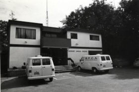
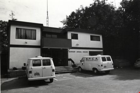
Burnaby Animal Shelter
https://search.heritageburnaby.ca/link/archivedescription79576
- Repository
- City of Burnaby Archives
- Date
- October, 1976
- Collection/Fonds
- Burnaby Public Library Contemporary Visual Archive Project
- Description Level
- Item
- Physical Description
- 1 photograph : b&w ; 11 x 16 cm mounted on cardboard
- Scope and Content
- Photograph shows the Burnaby Animal Shelter at 3202 Norland Avenue near Douglas Road. The building was opened on December 22, 1969 and is operated by the SPCA.
- Repository
- City of Burnaby Archives
- Date
- October, 1976
- Collection/Fonds
- Burnaby Public Library Contemporary Visual Archive Project
- Physical Description
- 1 photograph : b&w ; 11 x 16 cm mounted on cardboard
- Description Level
- Item
- Record No.
- 556-340
- Access Restriction
- No restrictions
- Reproduction Restriction
- Reproduce for fair dealing purposes only
- Accession Number
- 2013-13
- Scope and Content
- Photograph shows the Burnaby Animal Shelter at 3202 Norland Avenue near Douglas Road. The building was opened on December 22, 1969 and is operated by the SPCA.
- Media Type
- Photograph
- Photographer
- Cook, Alan
- Notes
- Scope note taken directly from BPL photograph description.
- 1 b&w copy negative : 10 x 12.5 cm accompanying
- Geographic Access
- Norland Avenue
- Street Address
- 3202 Norland Avenue
- Historic Neighbourhood
- Burnaby Lake (Historic Neighbourhood)
- Planning Study Area
- Ardingley-Sprott Area
Images

C.F. Sprott's house
https://search.heritageburnaby.ca/link/archivedescription34498
- Repository
- City of Burnaby Archives
- Date
- 1908
- Collection/Fonds
- Burnaby Historical Society fonds
- Description Level
- Item
- Physical Description
- 1 photograph : sepia ; 12.8 x 17.7 cm mounted on cardboard 14.8 x 19.7 cm
- Scope and Content
- Photograph of C.F. Sprott's House at Douglas Road and Norland Avenue. A unidentified man is standing on the porch steps.
- Repository
- City of Burnaby Archives
- Date
- 1908
- Collection/Fonds
- Burnaby Historical Society fonds
- Subseries
- Photographs subseries
- Physical Description
- 1 photograph : sepia ; 12.8 x 17.7 cm mounted on cardboard 14.8 x 19.7 cm
- Description Level
- Item
- Record No.
- 022-001
- Access Restriction
- No restrictions
- Reproduction Restriction
- No known restrictions
- Accession Number
- BHS2007-04
- Scope and Content
- Photograph of C.F. Sprott's House at Douglas Road and Norland Avenue. A unidentified man is standing on the porch steps.
- Media Type
- Photograph
- Photographer
- Cooksley, William Thomas
- Notes
- Title based on contents of photograph
- Annotation at bottom of photograph reads, "C.F. Sprott's Residence, Fruit Farm, Burnaby B.C."
- Annotation underneath photograph reads, "W.T. Cooksley, New Westminster, B.C."
- Geographic Access
- Douglas Road
- Norland Avenue
- Historic Neighbourhood
- Burnaby Lake (Historic Neighbourhood)
- Planning Study Area
- Ardingley-Sprott Area
Images

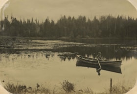
Claude Hill on Deer Lake
https://search.heritageburnaby.ca/link/archivedescription39521
- Repository
- City of Burnaby Archives
- Date
- 1906
- Collection/Fonds
- Peers Family and Hill Family fonds
- Description Level
- Item
- Physical Description
- 1 photograph : b&w ; 11.3 x 16.3 cm on page 21.5 x 28 cm (pasted in album)
- Scope and Content
- Photograph of Claude Hill sitting in a rowboat on Deer Lake. The photograph was taken looking southwest across Deer Lake.
- Repository
- City of Burnaby Archives
- Date
- 1906
- Collection/Fonds
- Peers Family and Hill Family fonds
- Physical Description
- 1 photograph : b&w ; 11.3 x 16.3 cm on page 21.5 x 28 cm (pasted in album)
- Description Level
- Item
- Record No.
- 477-840
- Access Restriction
- No restrictions
- Reproduction Restriction
- No known restrictions
- Accession Number
- 2007-12
- Scope and Content
- Photograph of Claude Hill sitting in a rowboat on Deer Lake. The photograph was taken looking southwest across Deer Lake.
- Media Type
- Photograph
- Photographer
- Cooksley, William Thomas
- Notes
- Title based on caption accompanying photograph
- Geographic Access
- Deer Lake
- Historic Neighbourhood
- Burnaby Lake (Historic Neighbourhood)
Images


Deer Lake, Burnaby BC
https://search.heritageburnaby.ca/link/archivedescription38513
- Repository
- City of Burnaby Archives
- Date
- 1908
- Collection/Fonds
- Burnaby Historical Society fonds
- Description Level
- Item
- Physical Description
- 1 photograph : b&w postcard ; 9 x 14 cm
- Scope and Content
- Photographic postcard of Deer Lake. Stamped on the front of the card is the name of the photographer, W.T. Cooksley and the picture has been captioned "Deer Lake, Burnaby BC." The card bears a postmark dated 1908 at New Westminster.
- Repository
- City of Burnaby Archives
- Date
- 1908
- Collection/Fonds
- Burnaby Historical Society fonds
- Subseries
- Photographs subseries
- Physical Description
- 1 photograph : b&w postcard ; 9 x 14 cm
- Description Level
- Item
- Record No.
- 449-008
- Access Restriction
- No restrictions
- Reproduction Restriction
- No known restrictions
- Accession Number
- BHS2007-04
- Scope and Content
- Photographic postcard of Deer Lake. Stamped on the front of the card is the name of the photographer, W.T. Cooksley and the picture has been captioned "Deer Lake, Burnaby BC." The card bears a postmark dated 1908 at New Westminster.
- Media Type
- Photograph
- Photographer
- Cooksley, William Thomas
- Geographic Access
- Deer Lake
- Historic Neighbourhood
- Burnaby Lake (Historic Neighbourhood)
- Planning Study Area
- Morley-Buckingham Area
Images

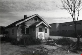
House on Norland Avenue
https://search.heritageburnaby.ca/link/archivedescription79438
- Repository
- City of Burnaby Archives
- Date
- October, 1976
- Collection/Fonds
- Burnaby Public Library Contemporary Visual Archive Project
- Description Level
- Item
- Physical Description
- 1 photograph : b&w ; 11 x 16 cm mounted on cardboard
- Scope and Content
- Photograph shows a vacant house at 2874 Norland Avenue with a sign advertising the property as an industrial site.
- Repository
- City of Burnaby Archives
- Date
- October, 1976
- Collection/Fonds
- Burnaby Public Library Contemporary Visual Archive Project
- Physical Description
- 1 photograph : b&w ; 11 x 16 cm mounted on cardboard
- Description Level
- Item
- Record No.
- 556-290
- Access Restriction
- No restrictions
- Reproduction Restriction
- Reproduce for fair dealing purposes only
- Accession Number
- 2013-13
- Scope and Content
- Photograph shows a vacant house at 2874 Norland Avenue with a sign advertising the property as an industrial site.
- Media Type
- Photograph
- Photographer
- Cook, Alan
- Notes
- Scope note taken directly from BPL photograph description.
- 1 b&w copy negative : 10 x 12.5 cm accompanying
- Geographic Access
- Norland Avenue
- Street Address
- 2874 Norland Avenue
- Historic Neighbourhood
- Burnaby Lake (Historic Neighbourhood)
- Planning Study Area
- Ardingley-Sprott Area
Images


L. Claude Hill's Farm, Burnaby BC
https://search.heritageburnaby.ca/link/archivedescription39550
- Repository
- City of Burnaby Archives
- Date
- 1906
- Collection/Fonds
- Peers Family and Hill Family fonds
- Description Level
- Item
- Physical Description
- 1 photograph : b&w ; 12.5 x 17.5 cm on page 21.5 x 28 cm (pasted in album)
- Scope and Content
- Photograph looking towards the Pole Line Road (later Sperling Avenue) from the farm belonging to Claude Hill and known as Broadview on Buckingham Avenue. This property formerly belonged to Malcolm Nicholson. A fence can be seen dividing the garden from the field and two men are standing alongside…
- Repository
- City of Burnaby Archives
- Date
- 1906
- Collection/Fonds
- Peers Family and Hill Family fonds
- Physical Description
- 1 photograph : b&w ; 12.5 x 17.5 cm on page 21.5 x 28 cm (pasted in album)
- Description Level
- Item
- Record No.
- 477-869
- Access Restriction
- No restrictions
- Reproduction Restriction
- No known restrictions
- Accession Number
- 2007-12
- Scope and Content
- Photograph looking towards the Pole Line Road (later Sperling Avenue) from the farm belonging to Claude Hill and known as Broadview on Buckingham Avenue. This property formerly belonged to Malcolm Nicholson. A fence can be seen dividing the garden from the field and two men are standing alongside with a horse and carriage nearby. Four children are walking in the field - from left to right, Kitty Hill, Ed Clayton, Gerry Hill and Florence Hart . A house can be seen in the background, this is most likely the cottage belonging to Harriet Woodward which served as the first school and post office at Burnaby Lake. To the right of the Woodward house can be seen the roof of the Claude Hill house known as Brookfield which was at 6501 Deer Lake Avenue and above that is a house on a hill which was the George Clayton home (on what later became the Henry and Grace Ceperley Fairacres estate at 6344 Deer Lake Avenue).
- Names
- Clayton, Edward
- Godwin, Florence Hart
- Hill, Minard Gerald "Gerry"
- Peers, Katherine Maude Hill "Kitty"
- Media Type
- Photograph
- Photographer
- Cooksley, William Thomas
- Notes
- Title based on caption accompanying photograph
- Geographic Access
- Deer Lake Avenue
- Buckingham Avenue
- Sperling Avenue
- Street Address
- 6501 Deer Lake Avenue
- 5141 Sperling Avenue
- 5730 Buckingham Avenue
- Historic Neighbourhood
- Burnaby Lake (Historic Neighbourhood)
- Planning Study Area
- Morley-Buckingham Area
Images

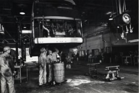
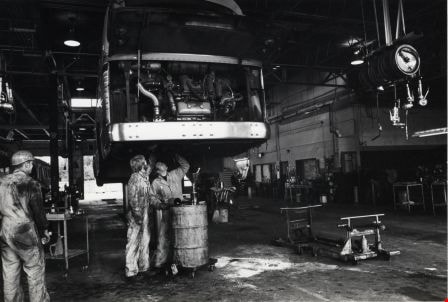
Mechanics working on bus
https://search.heritageburnaby.ca/link/archivedescription79478
- Repository
- City of Burnaby Archives
- Date
- October, 1976
- Collection/Fonds
- Burnaby Public Library Contemporary Visual Archive Project
- Description Level
- Item
- Physical Description
- 1 photograph : b&w ; 11 x 16 cm mounted on cardboard
- Scope and Content
- Photograph shows mechanics working on a bus at the garage on Sprott Street. The building was constructed in 1967.
- Repository
- City of Burnaby Archives
- Date
- October, 1976
- Collection/Fonds
- Burnaby Public Library Contemporary Visual Archive Project
- Physical Description
- 1 photograph : b&w ; 11 x 16 cm mounted on cardboard
- Description Level
- Item
- Record No.
- 556-310
- Access Restriction
- No restrictions
- Reproduction Restriction
- Reproduce for fair dealing purposes only
- Accession Number
- 2013-13
- Scope and Content
- Photograph shows mechanics working on a bus at the garage on Sprott Street. The building was constructed in 1967.
- Subjects
- Transportation - Buses
- Media Type
- Photograph
- Photographer
- Cook, Alan
- Notes
- Scope note taken directly from BPL photograph description.
- 1 b&w copy negative : 10 x 12.5 cm accompanying
- Geographic Access
- Sprott Street
- Street Address
- 6556 Sprott Street
- Historic Neighbourhood
- Burnaby Lake (Historic Neighbourhood)
- Planning Study Area
- Ardingley-Sprott Area
Images
![Mowing at Gaines' Farm, Burnaby, [1906] thumbnail](/media/hpo/_Data/_Archives_Images/_Unrestricted/477/477-867.jpg?width=280)
Mowing at Gaines' Farm, Burnaby
https://search.heritageburnaby.ca/link/archivedescription39548
- Repository
- City of Burnaby Archives
- Date
- [1906]
- Collection/Fonds
- Peers Family and Hill Family fonds
- Description Level
- Item
- Physical Description
- 1 photograph : b&w ; 12 x 17 cm on page 21.5 x 28 cm (pasted in album)
- Scope and Content
- Photograph of a farmer driving a team of two horses mowing hay in a field. The photograph bears the caption "Mowing at Gaines' farm" and is accompanied by a notation in the album indicating that the field was across Douglas Road from Brookfield, the home of Claude Hill. This property belonged to …
- Repository
- City of Burnaby Archives
- Date
- [1906]
- Collection/Fonds
- Peers Family and Hill Family fonds
- Physical Description
- 1 photograph : b&w ; 12 x 17 cm on page 21.5 x 28 cm (pasted in album)
- Description Level
- Item
- Record No.
- 477-867
- Access Restriction
- No restrictions
- Reproduction Restriction
- No known restrictions
- Accession Number
- 2007-12
- Scope and Content
- Photograph of a farmer driving a team of two horses mowing hay in a field. The photograph bears the caption "Mowing at Gaines' farm" and is accompanied by a notation in the album indicating that the field was across Douglas Road from Brookfield, the home of Claude Hill. This property belonged to Claude's brother Bernard Hill and was later known as 4990 Canada Way. The man is unidentified. In the background to the west can be seen Burnaby Lake and to the left the Pole Line Road (later Sperling Avenue) and to the right, Douglas Road and an unidentified house. This is the current location of the Kensington Avenue freeway interchange.
- Subjects
- Agriculture - Crops
- Agricultural Tools and Equipment
- Animals - Horses
- Occupations - Farmers
- Media Type
- Photograph
- Photographer
- Cooksley, William Thomas
- Notes
- Title based on caption accompanying photograph
- Geographic Access
- Deer Lake Avenue
- Canada Way
- Douglas Road
- Street Address
- 4990 Canada Way
- Historic Neighbourhood
- Burnaby Lake (Historic Neighbourhood)
- Planning Study Area
- Douglas-Gilpin Area
Images
![Mowing at Gaines' Farm, Burnaby, [1906] thumbnail](/media/hpo/_Data/_Archives_Images/_Unrestricted/477/477-867.jpg)
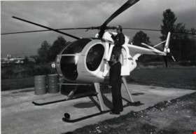
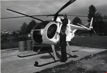
Transwest Helicopters
https://search.heritageburnaby.ca/link/archivedescription79404
- Repository
- City of Burnaby Archives
- Date
- October, 1976
- Collection/Fonds
- Burnaby Public Library Contemporary Visual Archive Project
- Description Level
- Item
- Physical Description
- 1 photograph : b&w ; 11 x 16 cm mounted on cardboard
- Scope and Content
- Photograph shows Vice President, Richard Burton, and an engineer of Transwest Helicopters (1965) Ltd. beside one of their helicopters at 2792 Norland Avenue. Although the company was formed in 1965, it did not move to Norland Avenue until 1969.
- Repository
- City of Burnaby Archives
- Date
- October, 1976
- Collection/Fonds
- Burnaby Public Library Contemporary Visual Archive Project
- Physical Description
- 1 photograph : b&w ; 11 x 16 cm mounted on cardboard
- Description Level
- Item
- Record No.
- 556-279
- Access Restriction
- No restrictions
- Reproduction Restriction
- Reproduce for fair dealing purposes only
- Accession Number
- 2013-13
- Scope and Content
- Photograph shows Vice President, Richard Burton, and an engineer of Transwest Helicopters (1965) Ltd. beside one of their helicopters at 2792 Norland Avenue. Although the company was formed in 1965, it did not move to Norland Avenue until 1969.
- Subjects
- Transportation - Air
- Media Type
- Photograph
- Photographer
- Cook, Alan
- Notes
- Scope note taken directly from BPL photograph description.
- 1 b&w copy negative : 10 x 12.5 cm accompanying
- Geographic Access
- Norland Avenue
- Street Address
- 2792 Norland Avenue
- Historic Neighbourhood
- Burnaby Lake (Historic Neighbourhood)
- Planning Study Area
- Ardingley-Sprott Area
Images