Narrow Results By
Subject
- Accidents - Automobile Accidents 1
- Aerial Photographs 2
- Agricultural Tools and Equipment 2
- Agricultural Tools and Equipment - Gardening Equipment 1
- Agriculture - Farms 10
- Agriculture - Fruit and Berries 1
- Animals - Dogs 8
- Animals - Horses 6
- Animals - Pigs 1
- Buildings - Commercial - Stores 1
- Buildings - Heritage 15
- Buildings - Industrial - Mills 1
Person / Organization
- Andrusiak, Margaret Martin Greenall 8
- Banford, Dodie Rutherford 1
- Bateman, Edwin W. 1
- Bateman, Marianne May 2
- Bateman, Mary Dale 1
- Bingham, Alfred "Alf" 2
- Boal, Ethel May Jackson 2
- Boal, Glen 5
- Boal, Thomas "Tom" 2
- Boal, William Ewart 2
- Burnaby Central Secondary School 1
- Burnaby Lake Riding Academy 2
![Edna Cunningham with Kathleen Montgomery, [1929 or 1930] thumbnail](/media/hpo/_Data/_Archives_Images/_Unrestricted/550/554-013.jpg?width=280)
Edna Cunningham with Kathleen Montgomery
https://search.heritageburnaby.ca/link/archivedescription80162
- Repository
- City of Burnaby Archives
- Date
- [1929 or 1930]
- Collection/Fonds
- Montgomery family fonds
- Description Level
- Item
- Physical Description
- 1 photograph : b&w ; 7 x 12 cm
- Scope and Content
- Photograph of Edna Cunningham with a brush in her hand, kneeling beside Margery Kathleen "Kathleen" Montgomery (later Green). This photograph was taken during Kathleen's stay at Fred and Edna Cunningham's house on Douglas Road.
- Repository
- City of Burnaby Archives
- Date
- [1929 or 1930]
- Collection/Fonds
- Montgomery family fonds
- Physical Description
- 1 photograph : b&w ; 7 x 12 cm
- Description Level
- Item
- Record No.
- 554-013
- Access Restriction
- No restrictions
- Reproduction Restriction
- No known restrictions
- Accession Number
- 2013-14
- Scope and Content
- Photograph of Edna Cunningham with a brush in her hand, kneeling beside Margery Kathleen "Kathleen" Montgomery (later Green). This photograph was taken during Kathleen's stay at Fred and Edna Cunningham's house on Douglas Road.
- Media Type
- Photograph
- Notes
- Title based on contents of photograph
- Street Address
- 3555 Douglas Road
- Historic Neighbourhood
- Burnaby Lake (Historic Neighbourhood)
- Planning Study Area
- Douglas-Gilpin Area
Images
![Edna Cunningham with Kathleen Montgomery, [1929 or 1930] thumbnail](/media/hpo/_Data/_Archives_Images/_Unrestricted/550/554-013.jpg)
![Map of proposed provincial exhibition site at Burnaby Lake, [between 1929 and 1931] thumbnail](/media/hpo/_Data/_BVM_Cartographic_Material/2017/2017_0002_0009_005.jpg?width=280)
Map of proposed provincial exhibition site at Burnaby Lake
https://search.heritageburnaby.ca/link/museumdescription8703
- Repository
- Burnaby Village Museum
- Date
- [between 1929 and 1931]
- Collection/Fonds
- Burnaby Village Museum Map collection
- Description Level
- Item
- Physical Description
- 1 map : photostat print ; 3 parts 45 x 33.7 cm totalling 45 x 101 cm
- Scope and Content
- Item consists of a tri-part folding map of a proposed Provincial Exhibition site located along the southern and western shore of Burnaby Lake. Exhibtion site on map identifies proposed locations for a golf course, pier, hydroplane landing ramp, sports ground, one-mile horse racing track and various…
- Repository
- Burnaby Village Museum
- Collection/Fonds
- Burnaby Village Museum Map collection
- Description Level
- Item
- Physical Description
- 1 map : photostat print ; 3 parts 45 x 33.7 cm totalling 45 x 101 cm
- Material Details
- Scale [1:1800]
- Scope and Content
- Item consists of a tri-part folding map of a proposed Provincial Exhibition site located along the southern and western shore of Burnaby Lake. Exhibtion site on map identifies proposed locations for a golf course, pier, hydroplane landing ramp, sports ground, one-mile horse racing track and various buildings for mechanical, agricultural and botanical displays.
- Subjects
- Exhibitions
- Accession Code
- BV017.2.9
- Access Restriction
- No restrictions
- Reproduction Restriction
- No known restrictions
- Date
- [between 1929 and 1931]
- Media Type
- Cartographic Material
- Historic Neighbourhood
- Burnaby Lake (Historic Neighbourhood)
- Planning Study Area
- Burnaby Lake Area
- Scan Resolution
- 400
- Scan Date
- 2021-11-18
- Notes
- Title based on contents of map
- Scale on map reads: "150 feet to 1 inch"
- Overall measurements when fully opened: L: 98.0 cm x H: 45.3 cm ; Individual map parts: L: 32.7 cm x H: 45.0 cm
- Commercially printed label on front of portfolio card reads "PLOWRIGHT PRINTING COMPANY / TELEPHONE N.W. 1942 / 39 McKENZIE STREET NEW WESTMINSTER, B.C. / TO: [illegible writing in pencil]" in blue ink. Red typewritten text reads: "PHOTOSTAT OF BURNABY LAKE".
Images
![Map of proposed provincial exhibition site at Burnaby Lake, [between 1929 and 1931] thumbnail](/media/hpo/_Data/_BVM_Cartographic_Material/2017/2017_0002_0009_005.jpg)


![Eight Clergymen at Saint Theresa's Roman Catholic Church, [192-] thumbnail](/media/hpo/_Data/_BVM_Images/1975/1975_0105_0003_001.jpg?width=280)
Eight Clergymen at Saint Theresa's Roman Catholic Church
https://search.heritageburnaby.ca/link/museumdescription904
- Repository
- Burnaby Village Museum
- Date
- [192-]
- Collection/Fonds
- Burnaby Village Museum Photograph collection
- Description Level
- Item
- Physical Description
- 1 photograph : b&w ; 5.7 x 8.2 cm
- Scope and Content
- Photograph of eight unidentified clergymen posed outside in front of a brick building. Four are standing and the other four are seated in front of the standing men. On the right side of the photo, there is a sign that reads, "In Your Prayers / Kindly Remember." The location has been identified as…
- Repository
- Burnaby Village Museum
- Collection/Fonds
- Burnaby Village Museum Photograph collection
- Description Level
- Item
- Physical Description
- 1 photograph : b&w ; 5.7 x 8.2 cm
- Scope and Content
- Photograph of eight unidentified clergymen posed outside in front of a brick building. Four are standing and the other four are seated in front of the standing men. On the right side of the photo, there is a sign that reads, "In Your Prayers / Kindly Remember." The location has been identified as Saint Theresa's Roman Catholic Church. The church was located at the southeast corner of Canada Way and Laurel Street. Built in 1929, it was torn down in 1974, and a new church, St.Theresa's Parish, was built across the street.
- Subjects
- Occupations - Clergy
- Geographic Access
- Douglas Road
- Canada Way
- Laurel Street
- Accession Code
- HV975.105.3
- Access Restriction
- No restrictions
- Reproduction Restriction
- May be restricted by third party rights
- Date
- [192-]
- Media Type
- Photograph
- Historic Neighbourhood
- Burnaby Lake (Historic Neighbourhood)
- Planning Study Area
- Douglas-Gilpin Area
- Scan Resolution
- 600
- Scan Date
- 2023-06-13
- Notes
- Title based on contents of photograph
Images
![Eight Clergymen at Saint Theresa's Roman Catholic Church, [192-] thumbnail](/media/hpo/_Data/_BVM_Images/1975/1975_0105_0003_001.jpg)
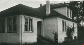
![McWilliams house, [193-] thumbnail](/media/hpo/_Data/_BVM_Images/1990/199400220001.jpg?width=280)
McWilliams house
https://search.heritageburnaby.ca/link/museumdescription3127
- Repository
- Burnaby Village Museum
- Date
- [193-]
- Collection/Fonds
- E.W. Bateman family fonds
- Description Level
- Item
- Physical Description
- 1 photograph : b&w ; 5 x 8 cm
- Scope and Content
- Photograph of the McWilliams house on Douglas Road. The house has a large patio area with a gravel road in front and a wood fence behind. A boy is sitting with a dog on the front steps. Mamie Bateman McWilliams lived here with her family, and is the daughter of Edwin Wettenhall Bateman, who built E…
- Repository
- Burnaby Village Museum
- Collection/Fonds
- E.W. Bateman family fonds
- Description Level
- Item
- Physical Description
- 1 photograph : b&w ; 5 x 8 cm
- Scope and Content
- Photograph of the McWilliams house on Douglas Road. The house has a large patio area with a gravel road in front and a wood fence behind. A boy is sitting with a dog on the front steps. Mamie Bateman McWilliams lived here with her family, and is the daughter of Edwin Wettenhall Bateman, who built Elworth (directly across the street).
- Subjects
- Buildings - Residential - Houses
- Geographic Access
- Douglas Road
- Accession Code
- BV994.22.1
- Access Restriction
- No restrictions
- Reproduction Restriction
- No known restrictions
- Date
- [193-]
- Media Type
- Photograph
- Historic Neighbourhood
- Burnaby Lake (Historic Neighbourhood)
- Planning Study Area
- Morley-Buckingham Area
- Scan Resolution
- 600
- Scan Date
- 01-Jun-09
- Scale
- 100
- Notes
- Title based on contents of photograph
Images
![McWilliams house, [193-] thumbnail](/media/hpo/_Data/_BVM_Images/1990/199400220001.jpg)
![McWilliams house, [193-] thumbnail](/media/hpo/_Data/_BVM_Images/1990/199400220002.jpg?width=280)
McWilliams house
https://search.heritageburnaby.ca/link/museumdescription3128
- Repository
- Burnaby Village Museum
- Date
- [193-]
- Collection/Fonds
- E.W. Bateman family fonds
- Description Level
- Item
- Physical Description
- 1 photograph : b&w ; 6 x 10.5 cm
- Scope and Content
- Photograph of the McWilliams house on Douglas Road. Mamie Bateman McWilliams lived here with her family and is the daughter of Edwin Wettenhall Bateman, who built Elworth (directly across the street).
- Repository
- Burnaby Village Museum
- Collection/Fonds
- E.W. Bateman family fonds
- Description Level
- Item
- Physical Description
- 1 photograph : b&w ; 6 x 10.5 cm
- Scope and Content
- Photograph of the McWilliams house on Douglas Road. Mamie Bateman McWilliams lived here with her family and is the daughter of Edwin Wettenhall Bateman, who built Elworth (directly across the street).
- Subjects
- Buildings - Residential - Houses
- Geographic Access
- Douglas Road
- Accession Code
- BV994.22.2
- Access Restriction
- No restrictions
- Reproduction Restriction
- No known restrictions
- Date
- [193-]
- Media Type
- Photograph
- Historic Neighbourhood
- Burnaby Lake (Historic Neighbourhood)
- Planning Study Area
- Morley-Buckingham Area
- Scan Resolution
- 600
- Scan Date
- 01-Jun-09
- Scale
- 100
- Notes
- Title based on contents of photograph
Images
![McWilliams house, [193-] thumbnail](/media/hpo/_Data/_BVM_Images/1990/199400220002.jpg)

Stowe Residence
https://search.heritageburnaby.ca/link/landmark642
- Repository
- Burnaby Heritage Planning
- Description
- Residential building.
- Associated Dates
- 1930
- Street View URL
- Google Maps Street View
- Repository
- Burnaby Heritage Planning
- Geographic Access
- Burris Street
- Associated Dates
- 1930
- Description
- Residential building.
- Heritage Value
- This charming home was built for George Norman Stowe (1885-1955) and his wife Lillian (née Ross) Stowe after they purchased this property from the Municipality of Burnaby in a Depression-era tax sale. George Stowe was a civil engineer with the Provincial Department of Public Works from 1905 until 1950. Inspired by the British Arts and Crafts movement, this stuccoed cottage is notable for its picturesque side gabled roof with sloped eaves, and a jerkin-headed dormer with half-timbering. Multi-paned casement windows are used throughout the house, adding to the picturesque effect. A verandah with a colonnade of pillars on the east side of the home overlooks a ravine.
- Locality
- Burnaby Lake
- Historic Neighbourhood
- Burnaby Lake (Historic Neighbourhood)
- Planning Study Area
- Morley-Buckingham Area
- Area
- 1963.96
- Contributing Resource
- Building
- Ownership
- Private
- Street Address
- 7484 Burris Street
- Street View URL
- Google Maps Street View
Images

![McWilliams house, [193-] thumbnail](/media/hpo/_Data/_BVM_Images/1990/199400220003.jpg?width=280)
McWilliams house
https://search.heritageburnaby.ca/link/museumdescription1196
- Repository
- Burnaby Village Museum
- Date
- [193-]
- Collection/Fonds
- E.W. Bateman family fonds
- Description Level
- Item
- Physical Description
- 1 photograph : sepia ; 6.5 x 12 cm
- Scope and Content
- Photograph of the McWilliams house on Douglas Road. Mamie Bateman McWilliams lived here with her family and is the daughter of Edwin Wettenhall Bateman, who built Elworth (directly across the street).
- Repository
- Burnaby Village Museum
- Collection/Fonds
- E.W. Bateman family fonds
- Description Level
- Item
- Physical Description
- 1 photograph : sepia ; 6.5 x 12 cm
- Scope and Content
- Photograph of the McWilliams house on Douglas Road. Mamie Bateman McWilliams lived here with her family and is the daughter of Edwin Wettenhall Bateman, who built Elworth (directly across the street).
- Subjects
- Buildings - Residential - Houses
- Geographic Access
- Douglas Road
- Accession Code
- BV994.22.3
- Access Restriction
- No restrictions
- Reproduction Restriction
- No known restrictions
- Date
- [193-]
- Media Type
- Photograph
- Historic Neighbourhood
- Burnaby Lake (Historic Neighbourhood)
- Planning Study Area
- Morley-Buckingham Area
- Scan Resolution
- 600
- Scan Date
- 01-Jun-09
- Scale
- 100
- Notes
- Title based on contents of photograph
- Stamp on verso of photograph reads: "Better Pictures/ NuGloss/ PHOTO FINISH/ Vancouver Drug Co."
Images
![McWilliams house, [193-] thumbnail](/media/hpo/_Data/_BVM_Images/1990/199400220003.jpg)
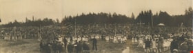
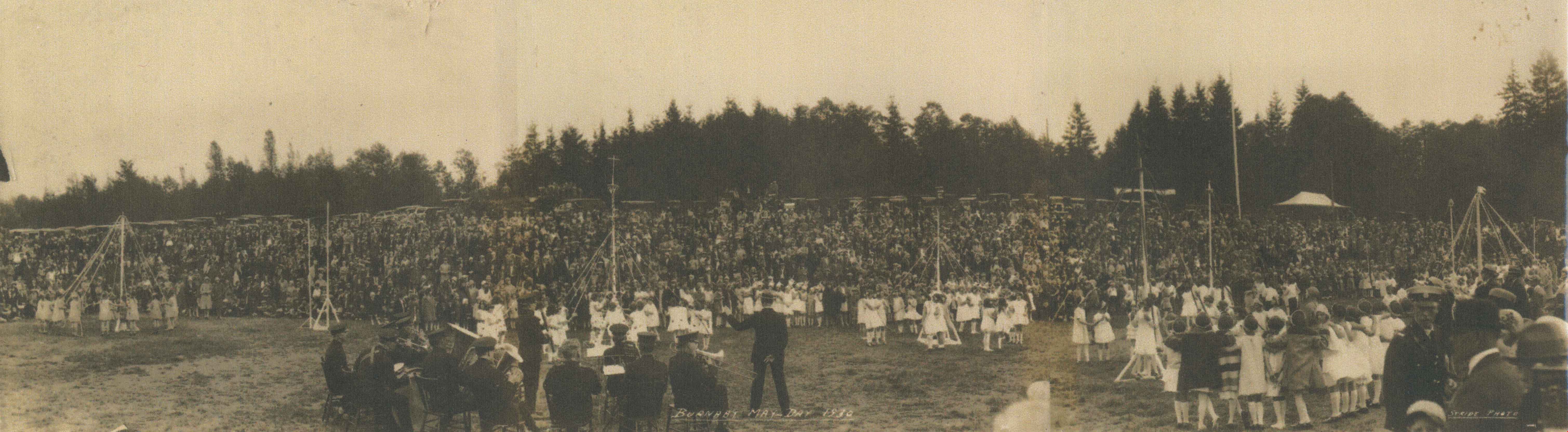
Burnaby May Day
https://search.heritageburnaby.ca/link/archivedescription34273
- Repository
- City of Burnaby Archives
- Date
- May 1930
- Collection/Fonds
- Burnaby Historical Society fonds
- Description Level
- Item
- Physical Description
- 1 photograph : b&w ; 26.5 x 96 cm
- Scope and Content
- Photograph of Burnaby May Day celebrations at Burnaby Park with a band in the foreground and children maypole dancing with a crowd watching. Parked cars and trees can be seen in the background.
- Repository
- City of Burnaby Archives
- Date
- May 1930
- Collection/Fonds
- Burnaby Historical Society fonds
- Subseries
- George Jeffery subseries
- Physical Description
- 1 photograph : b&w ; 26.5 x 96 cm
- Material Details
- Photograph consists of three photos taped together, stored folded at joints
- Description Level
- Item
- Record No.
- 013-017
- Access Restriction
- No restrictions
- Reproduction Restriction
- No known restrictions
- Accession Number
- BHS2007-04
- Scope and Content
- Photograph of Burnaby May Day celebrations at Burnaby Park with a band in the foreground and children maypole dancing with a crowd watching. Parked cars and trees can be seen in the background.
- Media Type
- Photograph
- Photographer
- Stride, Charles Edgar
- Notes
- Title based on caption of photograph
- Annotation at bottom of photograph reads, "Burnaby May Day 1930 / Stride Photo"
- Stamp on back of photograph reads, "Enlarged by The Stride Studios / 657 Columbia Street, New Westminster, BC / We do picture framing"
- Geographic Access
- Robert Burnaby Park
- Wedgewood Street
- Street Address
- 8155 Wedgewood Street
- Historic Neighbourhood
- Burnaby Lake (Historic Neighbourhood)
- Planning Study Area
- Lakeview-Mayfield Area
Images
![Burnaby Lake, [193-] thumbnail](/media/hpo/_Data/_Archives_Images/_Unrestricted/001/072-001.jpg?width=280)
Burnaby Lake
https://search.heritageburnaby.ca/link/archivedescription34637
- Repository
- City of Burnaby Archives
- Date
- [193-]
- Collection/Fonds
- Burnaby Historical Society fonds
- Description Level
- Item
- Physical Description
- 1 photograph : b&w ; 12.7 x 20.3 cm
- Scope and Content
- Aerial photograph of Burnaby Lake and North Burnaby.
- Repository
- City of Burnaby Archives
- Date
- [193-]
- Collection/Fonds
- Burnaby Historical Society fonds
- Subseries
- Photographs subseries
- Physical Description
- 1 photograph : b&w ; 12.7 x 20.3 cm
- Description Level
- Item
- Record No.
- 072-001
- Access Restriction
- No restrictions
- Reproduction Restriction
- No known restrictions
- Accession Number
- BHS2007-04
- Scope and Content
- Aerial photograph of Burnaby Lake and North Burnaby.
- Media Type
- Photograph
- Notes
- Title based on contents of photograph
- Geographic Access
- Burnaby Lake
- Historic Neighbourhood
- Burnaby Lake (Historic Neighbourhood)
- Lozells (Historic Neighbourhood)
- Lochdale (Historic Neighbourhood)
- Planning Study Area
- Parkcrest-Aubrey Area
- Ardingley-Sprott Area
- Burnaby Lake Area
- Government Road Area
- Sperling-Broadway Area
- Lochdale Area
Images
![Burnaby Lake, [193-] thumbnail](/media/hpo/_Data/_Archives_Images/_Unrestricted/001/072-001.jpg)
![Deer Lake, [1930] (date of original), copied 1986 thumbnail](/media/hpo/_Data/_Archives_Images/_Unrestricted/126/160-003.jpg?width=280)
Deer Lake
https://search.heritageburnaby.ca/link/archivedescription34924
- Repository
- City of Burnaby Archives
- Date
- [1930] (date of original), copied 1986
- Collection/Fonds
- Burnaby Historical Society fonds
- Description Level
- Item
- Physical Description
- 1 photograph : b&w ; 17.7 x 12.6 cm print
- Scope and Content
- Photograph of swimmers at Deer Lake, some of whom are are standing on a wharf and some of whom are in the water.
- Repository
- City of Burnaby Archives
- Date
- [1930] (date of original), copied 1986
- Collection/Fonds
- Burnaby Historical Society fonds
- Subseries
- Bernard Bellinger subseries
- Physical Description
- 1 photograph : b&w ; 17.7 x 12.6 cm print
- Description Level
- Item
- Record No.
- 160-003
- Access Restriction
- No restrictions
- Reproduction Restriction
- No known restrictions
- Accession Number
- BHS1986-10
- Scope and Content
- Photograph of swimmers at Deer Lake, some of whom are are standing on a wharf and some of whom are in the water.
- Media Type
- Photograph
- Notes
- Title based on contents of photograph
- Geographic Access
- Deer Lake
- Deer Lake Avenue
- Historic Neighbourhood
- Burnaby Lake (Historic Neighbourhood)
- Planning Study Area
- Oakalla Area
Images
![Deer Lake, [1930] (date of original), copied 1986 thumbnail](/media/hpo/_Data/_Archives_Images/_Unrestricted/126/160-003.jpg)
![Still Creek Bridge, [1930] (date of original), copied 1986 thumbnail](/media/hpo/_Data/_Archives_Images/_Unrestricted/126/160-004.jpg?width=280)
Still Creek Bridge
https://search.heritageburnaby.ca/link/archivedescription34925
- Repository
- City of Burnaby Archives
- Date
- [1930] (date of original), copied 1986
- Collection/Fonds
- Burnaby Historical Society fonds
- Description Level
- Item
- Physical Description
- 1 photograph : b&w ; 12.4 x 8.7 cm print
- Scope and Content
- Photograph of five boys with bullrushes on the Still Creek Bridge, Douglas Road.
- Repository
- City of Burnaby Archives
- Date
- [1930] (date of original), copied 1986
- Collection/Fonds
- Burnaby Historical Society fonds
- Subseries
- Bernard Bellinger subseries
- Physical Description
- 1 photograph : b&w ; 12.4 x 8.7 cm print
- Description Level
- Item
- Record No.
- 160-004
- Access Restriction
- No restrictions
- Reproduction Restriction
- No known restrictions
- Accession Number
- BHS1986-10
- Scope and Content
- Photograph of five boys with bullrushes on the Still Creek Bridge, Douglas Road.
- Subjects
- Structures - Bridges
- Media Type
- Photograph
- Notes
- Title based on contents of photograph
- Geographic Access
- Douglas Road
- Still Creek Avenue
- Historic Neighbourhood
- Burnaby Lake (Historic Neighbourhood)
- Planning Study Area
- Dawson-Delta Area
- Ardingley-Sprott Area
Images
![Still Creek Bridge, [1930] (date of original), copied 1986 thumbnail](/media/hpo/_Data/_Archives_Images/_Unrestricted/126/160-004.jpg)
![Oakalla Prison Farm, [193-] (date of original), copied 1986 thumbnail](/media/hpo/_Data/_Archives_Images/_Unrestricted/126/179-003.jpg?width=280)
Oakalla Prison Farm
https://search.heritageburnaby.ca/link/archivedescription35032
- Repository
- City of Burnaby Archives
- Date
- [193-] (date of original), copied 1986
- Collection/Fonds
- Burnaby Historical Society fonds
- Description Level
- Item
- Physical Description
- 1 photograph : b&w ; 12.6 x 8.8 cm print
- Scope and Content
- Photograph of pigs outside at Oakalla Prison Farm. Deer Lake can be seen in the background.
- Repository
- City of Burnaby Archives
- Date
- [193-] (date of original), copied 1986
- Collection/Fonds
- Burnaby Historical Society fonds
- Subseries
- Chamberlain family subseries
- Physical Description
- 1 photograph : b&w ; 12.6 x 8.8 cm print
- Description Level
- Item
- Record No.
- 179-003
- Access Restriction
- No restrictions
- Reproduction Restriction
- No known restrictions
- Accession Number
- BHS1986-27
- Scope and Content
- Photograph of pigs outside at Oakalla Prison Farm. Deer Lake can be seen in the background.
- Names
- Oakalla Prison Farm
- Media Type
- Photograph
- Notes
- Title based on contents of photograph
- Geographic Access
- Oakmount Crescent
- Deer Lake
- Street Address
- 5220 Oakmount Crescent
- Historic Neighbourhood
- Burnaby Lake (Historic Neighbourhood)
- Planning Study Area
- Oakalla Area
Images
![Oakalla Prison Farm, [193-] (date of original), copied 1986 thumbnail](/media/hpo/_Data/_Archives_Images/_Unrestricted/126/179-003.jpg)

James Cowan
https://search.heritageburnaby.ca/link/archivedescription35193
- Repository
- City of Burnaby Archives
- Date
- 1930 (date of original), copied 1986
- Collection/Fonds
- Burnaby Historical Society fonds
- Description Level
- Item
- Physical Description
- 1 photograph : b&w ; 12.7 x 17.8 cm print
- Scope and Content
- Photograph of James Cowan working in the garden at his family home, 2930 Gilpin Street (later renumbered 5926 Gilpin Street).
- Repository
- City of Burnaby Archives
- Date
- 1930 (date of original), copied 1986
- Collection/Fonds
- Burnaby Historical Society fonds
- Subseries
- Pioneer Tales subseries
- Physical Description
- 1 photograph : b&w ; 12.7 x 17.8 cm print
- Description Level
- Item
- Record No.
- 204-050
- Access Restriction
- No restrictions
- Reproduction Restriction
- No known restrictions
- Accession Number
- BHS1988-03
- Scope and Content
- Photograph of James Cowan working in the garden at his family home, 2930 Gilpin Street (later renumbered 5926 Gilpin Street).
- Names
- Cowan, James
- Media Type
- Photograph
- Notes
- Title based on contents of photograph
- Geographic Access
- Gilpin Street
- Street Address
- 5926 Gilpin Street
- Historic Neighbourhood
- Burnaby Lake (Historic Neighbourhood)
- Planning Study Area
- Douglas-Gilpin Area
Images

Waplington family home
https://search.heritageburnaby.ca/link/archivedescription35617
- Repository
- City of Burnaby Archives
- Date
- 1930 (date of original), copied 1986
- Collection/Fonds
- Burnaby Historical Society fonds
- Description Level
- Item
- Physical Description
- 1 photograph : b&w ; 12.7 x 17.8 cm print
- Scope and Content
- Photograph of the Waplington family home. This house was originally "Brookfield," Claude Hill's family home. Jack Waplington bought the house in 1925 and engaged Claude Hill's brother, Bernard, to renovate it. The property later became the site of the Burnaby Village Museum. The man in the photogra…
- Repository
- City of Burnaby Archives
- Date
- 1930 (date of original), copied 1986
- Collection/Fonds
- Burnaby Historical Society fonds
- Subseries
- Pioneer Tales subseries
- Physical Description
- 1 photograph : b&w ; 12.7 x 17.8 cm print
- Description Level
- Item
- Record No.
- 204-475
- Access Restriction
- No restrictions
- Reproduction Restriction
- No known restrictions
- Accession Number
- BHS1988-03
- Scope and Content
- Photograph of the Waplington family home. This house was originally "Brookfield," Claude Hill's family home. Jack Waplington bought the house in 1925 and engaged Claude Hill's brother, Bernard, to renovate it. The property later became the site of the Burnaby Village Museum. The man in the photograph may be Claude Hill.
- Subjects
- Buildings - Residential - Houses
- Media Type
- Photograph
- Notes
- Title based on contents of photograph
- Geographic Access
- Deer Lake Avenue
- Street Address
- 6501 Deer Lake Avenue
- Historic Neighbourhood
- Burnaby Lake (Historic Neighbourhood)
- Planning Study Area
- Morley-Buckingham Area
Images

![Shaw family home, [1930] (date of original), copied 1992 thumbnail](/media/hpo/_Data/_Archives_Images/_Unrestricted/315/315-078.jpg?width=280)
Shaw family home
https://search.heritageburnaby.ca/link/archivedescription36723
- Repository
- City of Burnaby Archives
- Date
- [1930] (date of original), copied 1992
- Collection/Fonds
- Burnaby Historical Society fonds
- Description Level
- Item
- Physical Description
- 1 photograph : b&w ; 8.7 x 12.6 cm print
- Scope and Content
- Photograph of the home of Archie and Amy Shaw and their family at 663 Wedgewood Street (old street numbering system).
- Repository
- City of Burnaby Archives
- Date
- [1930] (date of original), copied 1992
- Collection/Fonds
- Burnaby Historical Society fonds
- Subseries
- Burnaby Centennial Anthology subseries
- Physical Description
- 1 photograph : b&w ; 8.7 x 12.6 cm print
- Description Level
- Item
- Record No.
- 315-078
- Access Restriction
- No restrictions
- Reproduction Restriction
- No known restrictions
- Accession Number
- BHS1994-04
- Scope and Content
- Photograph of the home of Archie and Amy Shaw and their family at 663 Wedgewood Street (old street numbering system).
- Subjects
- Buildings - Residential - Houses
- Media Type
- Photograph
- Notes
- Title based on contents of photograph
- Geographic Access
- Wedgewood Street
- Street Address
- 7863 Wedgewood Street
- Historic Neighbourhood
- Burnaby Lake (Historic Neighbourhood)
- Planning Study Area
- Lakeview-Mayfield Area
Images
![Shaw family home, [1930] (date of original), copied 1992 thumbnail](/media/hpo/_Data/_Archives_Images/_Unrestricted/315/315-078.jpg)
![Blythe Eagles in the garden, [1930] (date of original), copied 1996 thumbnail](/media/hpo/_Data/_Archives_Images/_Unrestricted/316/331-001.jpg?width=280)
Blythe Eagles in the garden
https://search.heritageburnaby.ca/link/archivedescription37183
- Repository
- City of Burnaby Archives
- Date
- [1930] (date of original), copied 1996
- Collection/Fonds
- Burnaby Historical Society fonds
- Description Level
- Item
- Physical Description
- 1 photograph : b&w ; 16.5 x 10 cm print
- Scope and Content
- Photograph of Blythe Eagles with his shirt off, working in the garden.
- Repository
- City of Burnaby Archives
- Date
- [1930] (date of original), copied 1996
- Collection/Fonds
- Burnaby Historical Society fonds
- Subseries
- Eagles family subseries
- Physical Description
- 1 photograph : b&w ; 16.5 x 10 cm print
- Description Level
- Item
- Record No.
- 331-001
- Access Restriction
- No restrictions
- Reproduction Restriction
- No known restrictions
- Accession Number
- BHS1996-21
- Scope and Content
- Photograph of Blythe Eagles with his shirt off, working in the garden.
- Names
- Eagles, Dr. Blythe
- Media Type
- Photograph
- Notes
- Title based on contents of photograph
- Geographic Access
- Sperling Avenue
- Street Address
- 5655 Sperling Avenue
- Historic Neighbourhood
- Burnaby Lake (Historic Neighbourhood)
- Planning Study Area
- Morley-Buckingham Area
Images
![Blythe Eagles in the garden, [1930] (date of original), copied 1996 thumbnail](/media/hpo/_Data/_Archives_Images/_Unrestricted/316/331-001.jpg)
![Eagles garden, [193-] (date of original), copied 1996 thumbnail](/media/hpo/_Data/_Archives_Images/_Unrestricted/316/331-002.jpg?width=280)
Eagles garden
https://search.heritageburnaby.ca/link/archivedescription37184
- Repository
- City of Burnaby Archives
- Date
- [193-] (date of original), copied 1996
- Collection/Fonds
- Burnaby Historical Society fonds
- Description Level
- Item
- Physical Description
- 1 photograph : b&w ; 10 x 17 cm print
- Scope and Content
- Photograph of a group of five people sitting and standing in the Eagles' garden.
- Repository
- City of Burnaby Archives
- Date
- [193-] (date of original), copied 1996
- Collection/Fonds
- Burnaby Historical Society fonds
- Subseries
- Eagles family subseries
- Physical Description
- 1 photograph : b&w ; 10 x 17 cm print
- Description Level
- Item
- Record No.
- 331-002
- Access Restriction
- No restrictions
- Reproduction Restriction
- No known restrictions
- Accession Number
- BHS1996-21
- Scope and Content
- Photograph of a group of five people sitting and standing in the Eagles' garden.
- Subjects
- Geographic Features - Gardens
- Media Type
- Photograph
- Notes
- Title based on contents of photograph
- Geographic Access
- Sperling Avenue
- Street Address
- 5655 Sperling Avenue
- Historic Neighbourhood
- Burnaby Lake (Historic Neighbourhood)
- Planning Study Area
- Morley-Buckingham Area
Images
![Eagles garden, [193-] (date of original), copied 1996 thumbnail](/media/hpo/_Data/_Archives_Images/_Unrestricted/316/331-002.jpg)
![Eagles garden, [193-] (date of original), copied 1996 thumbnail](/media/hpo/_Data/_Archives_Images/_Unrestricted/316/331-004.jpg?width=280)
Eagles garden
https://search.heritageburnaby.ca/link/archivedescription37186
- Repository
- City of Burnaby Archives
- Date
- [193-] (date of original), copied 1996
- Collection/Fonds
- Burnaby Historical Society fonds
- Description Level
- Item
- Physical Description
- 1 photograph : b&w ; 10 x 17 cm print
- Scope and Content
- Photograph of the Eagles' garden at the Eagles Estate.
- Repository
- City of Burnaby Archives
- Date
- [193-] (date of original), copied 1996
- Collection/Fonds
- Burnaby Historical Society fonds
- Subseries
- Eagles family subseries
- Physical Description
- 1 photograph : b&w ; 10 x 17 cm print
- Description Level
- Item
- Record No.
- 331-004
- Access Restriction
- No restrictions
- Reproduction Restriction
- No known restrictions
- Accession Number
- BHS1996-21
- Scope and Content
- Photograph of the Eagles' garden at the Eagles Estate.
- Subjects
- Geographic Features - Gardens
- Media Type
- Photograph
- Notes
- Title based on contents of photograph
- Geographic Access
- Sperling Avenue
- Street Address
- 5655 Sperling Avenue
- Historic Neighbourhood
- Burnaby Lake (Historic Neighbourhood)
- Planning Study Area
- Morley-Buckingham Area
Images
![Eagles garden, [193-] (date of original), copied 1996 thumbnail](/media/hpo/_Data/_Archives_Images/_Unrestricted/316/331-004.jpg)
![Eagles garden and house, [193-] (date of original), copied 1996 thumbnail](/media/hpo/_Data/_Archives_Images/_Unrestricted/316/331-005.jpg?width=280)
Eagles garden and house
https://search.heritageburnaby.ca/link/archivedescription37187
- Repository
- City of Burnaby Archives
- Date
- [193-] (date of original), copied 1996
- Collection/Fonds
- Burnaby Historical Society fonds
- Description Level
- Item
- Physical Description
- 1 photograph : b&w ; 10 x 17 cm print
- Scope and Content
- Photograph of five people standing in front of the Eagles' front door, at the Eagles Estate.
- Repository
- City of Burnaby Archives
- Date
- [193-] (date of original), copied 1996
- Collection/Fonds
- Burnaby Historical Society fonds
- Subseries
- Eagles family subseries
- Physical Description
- 1 photograph : b&w ; 10 x 17 cm print
- Description Level
- Item
- Record No.
- 331-005
- Access Restriction
- No restrictions
- Reproduction Restriction
- No known restrictions
- Accession Number
- BHS1996-21
- Scope and Content
- Photograph of five people standing in front of the Eagles' front door, at the Eagles Estate.
- Media Type
- Photograph
- Notes
- Title based on contents of photograph
- Geographic Access
- Sperling Avenue
- Street Address
- 5655 Sperling Avenue
- Historic Neighbourhood
- Burnaby Lake (Historic Neighbourhood)
- Planning Study Area
- Morley-Buckingham Area
Images
![Eagles garden and house, [193-] (date of original), copied 1996 thumbnail](/media/hpo/_Data/_Archives_Images/_Unrestricted/316/331-005.jpg)
![John Barker Lubbock and James Henry Jones, [1930] thumbnail](/media/hpo/_Data/_Archives_Images/_Unrestricted/316/342-005.jpg?width=280)
John Barker Lubbock and James Henry Jones
https://search.heritageburnaby.ca/link/archivedescription37231
- Repository
- City of Burnaby Archives
- Date
- [1930]
- Collection/Fonds
- Burnaby Historical Society fonds
- Description Level
- Item
- Physical Description
- 1 photograph : sepia ; 5.5 x 8 cm
- Scope and Content
- Photograph of John Barker Lubbock, father of the Lubbock children, and his friend, James Henry Jones smoking cigars in the yard at the Lubbock family farm house.
- Repository
- City of Burnaby Archives
- Date
- [1930]
- Collection/Fonds
- Burnaby Historical Society fonds
- Subseries
- Lubbock family subseries
- Physical Description
- 1 photograph : sepia ; 5.5 x 8 cm
- Description Level
- Item
- Record No.
- 342-005
- Access Restriction
- No restrictions
- Reproduction Restriction
- No known restrictions
- Accession Number
- BHS1994-02
- Scope and Content
- Photograph of John Barker Lubbock, father of the Lubbock children, and his friend, James Henry Jones smoking cigars in the yard at the Lubbock family farm house.
- Media Type
- Photograph
- Notes
- Title based on contents of photograph
- Geographic Access
- Grandview Highway
- Canada Way
- Burris Street
- Street Address
- 7803 Burris Street
- Historic Neighbourhood
- Burnaby Lake (Historic Neighbourhood)
- Planning Study Area
- Morley-Buckingham Area
Images
![John Barker Lubbock and James Henry Jones, [1930] thumbnail](/media/hpo/_Data/_Archives_Images/_Unrestricted/316/342-005.jpg)