Narrow Results By
Subject
- Advertising Medium - Signs and Signboards 1
- Agriculture - Farms 5
- Agriculture - Fruit and Berries 4
- Animals - Cats 1
- Animals - Dogs 7
- Animals - Fowl 1
- Animals - Goats 1
- Animals - Horses 1
- Buildings - Civic - Museums 1
- Buildings - Commercial - Restaurants 1
- Buildings - Heritage 6
- Buildings - Industrial - Mills 1

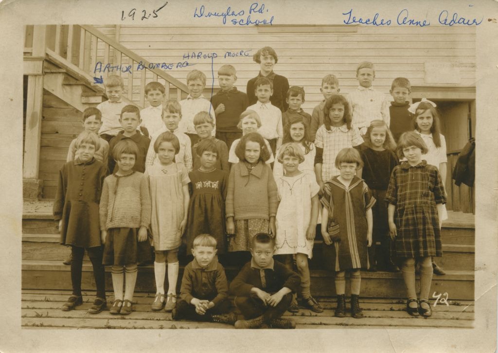
Students at Douglas Road School
https://search.heritageburnaby.ca/link/museumdescription78
- Repository
- Burnaby Village Museum
- Date
- 1925
- Collection/Fonds
- Burnaby Village Museum Photograph collection
- Description Level
- Item
- Physical Description
- 1 photograph : sepia ; 10.5 x 16 cm
- Scope and Content
- Photograph of students on the steps of Douglas Road School with their teacher, Annie Adair, standing in the centre at the very back. The boy standing on the extreme left at the back row is identified as Arthur Blomberg and the boy standing 4th from the left in the middle row is Harold Moore. The ot…
- Repository
- Burnaby Village Museum
- Collection/Fonds
- Burnaby Village Museum Photograph collection
- Description Level
- Item
- Physical Description
- 1 photograph : sepia ; 10.5 x 16 cm
- Scope and Content
- Photograph of students on the steps of Douglas Road School with their teacher, Annie Adair, standing in the centre at the very back. The boy standing on the extreme left at the back row is identified as Arthur Blomberg and the boy standing 4th from the left in the middle row is Harold Moore. The other students are not identified.
- Subjects
- Occupations - Teachers
- Geographic Access
- Canada Way
- Street Address
- 4861 Canada Way
- Accession Code
- BV989.28.1
- Access Restriction
- No restrictions
- Date
- 1925
- Media Type
- Photograph
- Historic Neighbourhood
- Burnaby Lake (Historic Neighbourhood)
- Planning Study Area
- Douglas-Gilpin Area
- Scan Resolution
- 600
- Scan Date
- 01-Jun-09
- Scale
- 100
- Notes
- Title based on contents of photograph
- Photographer identifies photograph as no. 42
- Notes on recto of photograph read: "Douglas Rd. school / Teacher Anne Adair / ARTHUR BLOMBERG / HAROLD MOORE" and "1925"
Images

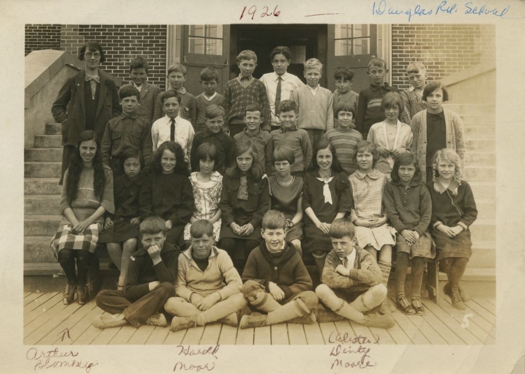
Students at Douglas Road School
https://search.heritageburnaby.ca/link/museumdescription79
- Repository
- Burnaby Village Museum
- Date
- 1926
- Collection/Fonds
- Burnaby Village Museum Photograph collection
- Description Level
- Item
- Physical Description
- 1 photograph : b&w ; 10.5 x 15.5 cm
- Scope and Content
- Photograph of students sitting and standing on the steps of Douglas Road School with their teacher (wearing glasses and an overcoat) on the far left at the back. In the front row, Arthur Blomberg is sitting on the far left, next to him is Harold Moore, with William A. "Dinty" Moore on the far right…
- Repository
- Burnaby Village Museum
- Collection/Fonds
- Burnaby Village Museum Photograph collection
- Description Level
- Item
- Physical Description
- 1 photograph : b&w ; 10.5 x 15.5 cm
- Scope and Content
- Photograph of students sitting and standing on the steps of Douglas Road School with their teacher (wearing glasses and an overcoat) on the far left at the back. In the front row, Arthur Blomberg is sitting on the far left, next to him is Harold Moore, with William A. "Dinty" Moore on the far right. The other students are not identified.
- Subjects
- Occupations - Teachers
- Geographic Access
- Canada Way
- Street Address
- 4861 Canada Way
- Accession Code
- BV989.28.2
- Access Restriction
- No restrictions
- Date
- 1926
- Media Type
- Photograph
- Historic Neighbourhood
- Burnaby Lake (Historic Neighbourhood)
- Planning Study Area
- Douglas-Gilpin Area
- Scan Resolution
- 600
- Scan Date
- 01-Jun-09
- Scale
- 100
- Notes
- Title based on contents of photograph
- Photographer identifies photograph as no. 5
- Notes on recto of photograph read: "Douglas Rd. School" and "1926 / Arthur Blomberg / Harold Moore / (Alister) Dinty Moore"
Images

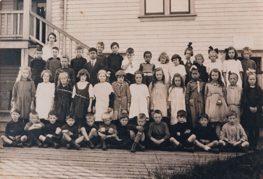
Students at Douglas Road School
https://search.heritageburnaby.ca/link/museumdescription1377
- Repository
- Burnaby Village Museum
- Date
- 1920
- Collection/Fonds
- Burnaby Village Museum Photograph collection
- Description Level
- Item
- Physical Description
- 1 photograph : sepia ; 17.5 x 25.5 cm print
- Scope and Content
- Photograph of Elsie Rummel (later McMurray) standing behind her students who are sitting and standing in rows outside Douglas Road school. Standing in the back two rows, left to right are; Jack Lort, Billy Mather, Teddy Norman (slightly in front), Ed Gavin, David Jung (slightly in front), Leonard R…
- Repository
- Burnaby Village Museum
- Collection/Fonds
- Burnaby Village Museum Photograph collection
- Description Level
- Item
- Physical Description
- 1 photograph : sepia ; 17.5 x 25.5 cm print
- Scope and Content
- Photograph of Elsie Rummel (later McMurray) standing behind her students who are sitting and standing in rows outside Douglas Road school. Standing in the back two rows, left to right are; Jack Lort, Billy Mather, Teddy Norman (slightly in front), Ed Gavin, David Jung (slightly in front), Leonard Rowley, Dave Banning, Herbert McConnell, Ying Jung, Gwendolyn Matthews, Avis Hart, Florence Cowan, Nancy Burnett, Winona Wood, Leona Smith, Sadie Bowie [or Dorothy Marsden]. Standing in the middle row are; Nora Rowley, Eva Dunnell [or Donnel], Rena Blomberg (later Ostby), Audrey [or Helen] Pontifex, Ruth Cole, Anna Matthews, Agnes Angus, Rhoda Gavin, Ruby Boucher, King Jung, Mary Lee, Frances "Fanny" Waplington (later Fleming), Beryl Hatch. Seated in the front row are; John Burnett [or Freddy Bogardus], John Waplington, Billy Townley, Roddie Saunders, Clive Cunningham, Ken Blott, Carl Banning, Doug Tyre, Bert Dawkins, Montague "Monty" Moore, John Moore and Alistair Westcott.
- Subjects
- Occupations - Teachers
- Names
- Douglas Road School
- McMurray, Elsie Rummel
- Lort, Jack
- Mather, Billy
- Norman, Teddy
- Gavin, Ed
- Jung, David
- Rowley, Leonard
- Banning, Dave
- McConnell, Herbert
- Jung, Suey Ying "Laura"
- Matthews, Gwendolyn
- Hart, Avis
- Cowan, Florence
- Burnett, Nancy
- Wood, Winona
- Smith, Leona
- Rowley, Nora
- Ostby, Rena Blomberg
- Cole, Ruth
- Matthews, Anna
- Angus, Agnes
- Gavin, Rhoda
- Boucher, Ruby
- Jung, King
- Lee, Mary
- Fleming, Frances "Fanny" Waplington
- Hatch, Beryl
- Waplington, John
- Townley, Billy
- Saunders, Roddie
- Cunningham, Clive
- Blott, Ken
- Banning, Carl
- Tyre, Doug
- Dawkins, Bert
- Moore, Montague Hutchings "Monty"
- Moore, John Gifford
- Westcott, Alistair
- Geographic Access
- Canada Way
- Street Address
- 4861 Canada Way
- Accession Code
- BV999.4.1
- Access Restriction
- No restrictions
- Reproduction Restriction
- No known restrictions
- Date
- 1920
- Media Type
- Photograph
- Historic Neighbourhood
- Burnaby Lake (Historic Neighbourhood)
- Planning Study Area
- Douglas-Gilpin Area
- Scan Resolution
- 600
- Scan Date
- 08-Jun-09
- Scale
- 100
- Notes
- Title based on contents of photograph
Images
![Subdivision plans in New Westminster District Group 1 – Burnaby
, [1893-1910] thumbnail](/media/hpo/_Data/_BVM_Cartographic_Material/1977/1977_0093_0016a_001.jpg?width=280)
Subdivision plans in New Westminster District Group 1 – Burnaby
https://search.heritageburnaby.ca/link/museumdescription6985
- Repository
- Burnaby Village Museum
- Date
- [1893-1910]
- Collection/Fonds
- Burnaby Village Museum Map collection
- Description Level
- File
- Physical Description
- 4 plans : blueprint ink on paper mounted on 2 sides of cardboard 76 x 102 cm
- Scope and Content
- Item consists of a large board of two New Westminster District Gp 1 - subdivision plans mounted on one side and two New Westminster District Gp 1 - subdivision plans mounted on the other side. Side A: 1. Blueprint "Plan / of Subdivision / of / Lot 6 / Group One / New Westminster District / Scale…
- Repository
- Burnaby Village Museum
- Collection/Fonds
- Burnaby Village Museum Map collection
- Description Level
- File
- Physical Description
- 4 plans : blueprint ink on paper mounted on 2 sides of cardboard 76 x 102 cm
- Material Details
- Scales [between 1:1584 and 1:3960]
- Index number on edge of board reads: "16"
- Scope and Content
- Item consists of a large board of two New Westminster District Gp 1 - subdivision plans mounted on one side and two New Westminster District Gp 1 - subdivision plans mounted on the other side. Side A: 1. Blueprint "Plan / of Subdivision / of / Lot 6 / Group One / New Westminster District / Scale 5 chs = 1 in. / Map No 748" (Geographic location: Burnaby) 2. Blueprint "Plan / of Subdivision / of a Portion / of / Lot 29 / Group One / New Westminster Dist. / Scale 2 chs = 1 in. / Map No." Name identified in Block H is "Reichenbach" (Geographic location: Burnaby) Side B: 1. Blueprint "Plan / of Subdivision / of North 1/2 of Lot 80 / Group One / New Westminster District / Scale 3 chs = 1 in. / Map No 719" Plan is signed by: "Garden, Hermon & Burwell P.L.S. / Vancouver Jan. 23rd, 1893" (Geographic location: Burnaby) 2. Blueprint "Plan / of Subdivision / of Lot 79, Gr.1 / New Westminster Dist. / Scale 4 chas = 1 in. / Map No 536" Plan is signed by "Garden Hermon & Burwell / Provincial Land Surveyors". (Geographic location: Burnaby)
- Creator
- Garden, Hermon and Burwell
- Accession Code
- HV977.93.16
- Access Restriction
- No restrictions
- Reproduction Restriction
- No known restrictions
- Date
- [1893-1910]
- Media Type
- Cartographic Material
- Historic Neighbourhood
- Edmonds (Historic Neighbourhood)
- Burnaby Lake (Historic Neighbourhood)
- Planning Study Area
- Douglas-Gilpin Area
- Edmonds Area
- Cameron Area
- Scan Resolution
- 300
- Scale
- 72
- Notes
- Title based on contents of file
- Scale is measured in chains. (One chain equals 792 inches)
- The term "Lot" can also refer to a "District Lot”
Images
![Subdivision plans in New Westminster District Group 1 – Burnaby
, [1893-1910] thumbnail](/media/hpo/_Data/_BVM_Cartographic_Material/1977/1977_0093_0016a_001.jpg)

![Survey and Subdivision plans in New Westminster District Group 1 – Burnaby, Port Moody, [1862-1908] thumbnail](/media/hpo/_Data/_BVM_Cartographic_Material/1977/1977_0093_0026a_001.jpg?width=280)
Survey and Subdivision plans in New Westminster District Group 1 – Burnaby, Port Moody
https://search.heritageburnaby.ca/link/museumdescription6995
- Repository
- Burnaby Village Museum
- Date
- [1862-1908]
- Collection/Fonds
- Burnaby Village Museum Map collection
- Description Level
- File
- Physical Description
- 9 plans : 6 plans : black ink on paper ; 57 x 36.5 cm or smaller + 1 plan : black ink and grahite on paper ; 46.5 x 49 cm + 1 plan : blueprint on paper ; 15.5 x 19.5 cm + cm + 1 plan : graphite on paper ; 25 x 17 cm ; mounted on both sides of board 76 x 102 cm
- Scope and Content
- Item consists of a large board of four New Westminster District subdivision plans mounted on one side and five New Westminster District subdivision plans mounted on the other side. Side A: 1. "Plan / of Subdivision / of a Portion / of / Lot 87 / Group One / New Westminster District / Scale 4 chs…
- Repository
- Burnaby Village Museum
- Collection/Fonds
- Burnaby Village Museum Map collection
- Description Level
- File
- Physical Description
- 9 plans : 6 plans : black ink on paper ; 57 x 36.5 cm or smaller + 1 plan : black ink and grahite on paper ; 46.5 x 49 cm + 1 plan : blueprint on paper ; 15.5 x 19.5 cm + cm + 1 plan : graphite on paper ; 25 x 17 cm ; mounted on both sides of board 76 x 102 cm
- Material Details
- Scales [between 1:792 and 1:3600]
- Index number on edge of board reads: "26"
- Scope and Content
- Item consists of a large board of four New Westminster District subdivision plans mounted on one side and five New Westminster District subdivision plans mounted on the other side. Side A: 1. "Plan / of Subdivision / of a Portion / of / Lot 87 / Group One / New Westminster District / Scale 4 chs = 1 in". Plan is stamped: "Albert J. Hill, Civil Engineer / and / Provincial Land Surveyor, / New Westminster, / B.C." and intialed by: "RB" [sic] (in blue pencil crayon). Names two of the subdivisons of District Lot 87 are identified as, "L.E. Sprott" and "John Ledger". (Geographic location: Burnaby) 2. "Plan of Subdivision / of / Portions of / Lot 136, 131 and Lots 44 and 78 Gr.1 / New Westminster District / Scale 300 ft = 1 inch". Annotation above title reads: "No. 901 / Deposited in Land Registry Office / New Westminster / Aug. 19th 1905 / Charles S. Keith D. Reg." Annotations and signatures at bottom of plan read: "I, William Nelson Draper, / W.H.R. Collister / Charles E. Perkins / E.B. Morgan / make / Surveys / correct / representation / upon / the / Land Registry Act / (sgd) W.N. Draper, P.L.S.". Plan includes a handwritten title: "Lots 136, 131, 44 & 78" and is initialed: "RB" [sic] (in blue pencil crayon) (Geographic location: Burnaby) 3. "Survey / of / a Portion / of / Lot 95, Gr.1 / Scale 1 ch = 1in." Plan is stamped: "Albert J. Hill, Civil Engineer / and / Provincial Land Surveyor, / New Westminster, / B.C." and is initialed : "RB" [sic] (in blue pencil crayon) (Geographic location: Burnaby) 4. Blueprint plan of "Lot 396. Group One." with Scale : 3 chs = 1 in. A two acre portion of District Lot 396 is filled in with red ink." Plan is signed by "Albert J. Hill / B.C.L.S." (Geographic location: Port Moody) Side B: 1. Plan titled "District Lot 92 / Burnaby / Municipality / for sale by / Mahon / McFarland & / Mahon Ltd. / Vancouver, B.C. / Scale : 4 chains to one inch". District Lot 92 is subdivided into 161 lots and identifies roads: Norwich Road, Pole Line Road, Oakland Road, Stanley Road, Burford Road, Dalhousie Road, Brantford Road, Colborne Road, Roberts Road, Vancouver & Westminster Road, B.C. Electric Railway, Gilley Stn. and Burnaby (Power House). The bottom of the plan reads: "G.S. Dawson, P.LS. Vancouver, B.C." (Geographic location: Burnaby) 2. "Plan / of Subdivision / of a Portion / of / Lot 29 / Group 1 / New Westminster District / Scale 2 chs = 1 in". Plan is stamped: "Albert J. Hill, Civil Engineer / and / Provincial Land Surveyor, / New Westminster, / B.C." and is initialed by: "RB" [sic] (in blue pencil crayon) (Geographic location: Burnaby) 3. Small handrawn plan (no title) identifying "Lot 84 / Hydes, Claim" at the centre surrounded by lots and features identified as: "Lot 85", "Lot 93", "Lot 94", "Lot 32", "Lot 82", "Lot 83", "Lot 79", "swamp" and a "Small Lake" (Burnaby Lake). Identifying marks in the right corner of the plan read: "Page 13 / Surveyed by G. Turner / May 62". Plan also includes surveyor's bearing measurements and trails to "Small Lake" (Burnaby Lake). (Geographic location: Burnaby) 4. Untitled plan showing District Lots west of North Road and north of Burnaby Lake including: Lots 2, 4, 6, 8, 15, 10, 56, 148, 57, 58, 40. and Lots 3, 5, 7 east of North Road (Coquitlam). Lots in Burnaby are identifed for timber including: "Heavily Timbered" (Lot 57), " "Some Fir and Cedar" (Lot 40), "Splendid Fir and Cedar" (Lot 143), "Heavy Fir etc" (Lots 143 and 148), " "Fine Cedar" (Lot 15), "Rough Light Timber" (Lot 56). Other features identified at the lower portion of the plan include "Burnaby Lake" and "Brunette River". (Geographic location: Burnaby) 5. Untitled plan drawn in graphite showing sections of District Lot 85 south of Burnaby Lake and north of Hazsard Road. Plan is signed: "Albert J. Hill / B.C.L.S." and dated "12/26/08". Plan is initialed by: "RB" [sic] (in blue pencil crayon) (Geographic location: Burnaby)
- Publisher
- Mahon, McFarland & Mahon Ltd
- Accession Code
- HV977.93.26
- Access Restriction
- No restrictions
- Reproduction Restriction
- No known restrictions
- Date
- [1862-1908]
- Media Type
- Cartographic Material
- Historic Neighbourhood
- Burnaby Lake (Historic Neighbourhood)
- Burquitlam (Historic Neighbourhood)
- Planning Study Area
- Burnaby Lake Area
- Scan Resolution
- 300
- Scale
- 72
- Notes
- Title based on contents of file
- Scale is measured in chains and feet. (One chain equals 792 inches)
- The term "Lot" can also refer to a "District Lot”
Images
![Survey and Subdivision plans in New Westminster District Group 1 – Burnaby, Port Moody, [1862-1908] thumbnail](/media/hpo/_Data/_BVM_Cartographic_Material/1977/1977_0093_0026a_001.jpg)


Tennis court
https://search.heritageburnaby.ca/link/archivedescription39217
- Repository
- City of Burnaby Archives
- Date
- 1926
- Collection/Fonds
- Peers Family and Hill Family fonds
- Description Level
- Item
- Physical Description
- 1 photograph : b&w ; 6 x 10.5 cm on page 24.5 x 32.5 cm (pasted in album)
- Scope and Content
- Photograph of the tennis court at the home of Kitty and Bob Peers on Deer Lake Avenue. The people in the photograph are unidentified.
- Repository
- City of Burnaby Archives
- Date
- 1926
- Collection/Fonds
- Peers Family and Hill Family fonds
- Physical Description
- 1 photograph : b&w ; 6 x 10.5 cm on page 24.5 x 32.5 cm (pasted in album)
- Description Level
- Item
- Record No.
- 477-536
- Access Restriction
- No restrictions
- Reproduction Restriction
- No known restrictions
- Accession Number
- 2007-12
- Scope and Content
- Photograph of the tennis court at the home of Kitty and Bob Peers on Deer Lake Avenue. The people in the photograph are unidentified.
- Subjects
- Sports - Tennis
- Media Type
- Photograph
- Notes
- Title based on caption accompanying photograph
- Geographic Access
- Deer Lake Avenue
- Street Address
- 6588 Deer Lake Avenue
- Historic Neighbourhood
- Burnaby Lake (Historic Neighbourhood)
- Planning Study Area
- Douglas-Gilpin Area
Images

The Tennis Courts Under Construction
https://search.heritageburnaby.ca/link/archivedescription39219
- Repository
- City of Burnaby Archives
- Date
- 1923
- Collection/Fonds
- Peers Family and Hill Family fonds
- Description Level
- Item
- Physical Description
- 1 photograph : b&w ; 6 x 10.8 cm on page 24.5 x 32.5 cm (pasted in album)
- Scope and Content
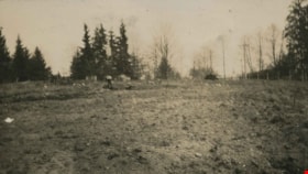
- Photograph shows the land clearing undertaken in preparation for the construction of tennis courts at the home of Bob and Kitty Peers family on Deer Lake Avenue.
- Repository
- City of Burnaby Archives
- Date
- 1923
- Collection/Fonds
- Peers Family and Hill Family fonds
- Physical Description
- 1 photograph : b&w ; 6 x 10.8 cm on page 24.5 x 32.5 cm (pasted in album)
- Description Level
- Item
- Record No.
- 477-538
- Access Restriction
- No restrictions
- Reproduction Restriction
- No known restrictions
- Accession Number
- 2007-12
- Scope and Content
- Photograph shows the land clearing undertaken in preparation for the construction of tennis courts at the home of Bob and Kitty Peers family on Deer Lake Avenue.
- Subjects
- Land Clearing
- Media Type
- Photograph
- Notes
- Title based on caption accompanying photograph
- Geographic Access
- Deer Lake Avenue
- Street Address
- 6588 Deer Lake Avenue
- Historic Neighbourhood
- Burnaby Lake (Historic Neighbourhood)
- Planning Study Area
- Douglas-Gilpin Area
Images

Trees and in the snow
https://search.heritageburnaby.ca/link/archivedescription39308
- Repository
- City of Burnaby Archives
- Date
- 1922
- Collection/Fonds
- Peers Family and Hill Family fonds
- Description Level
- Item
- Physical Description
- 1 photograph : b&w ; 6 x 10.4 cm on page 24.5 x 32.5 cm (pasted in album)
- Scope and Content
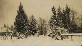
- Photograph of a field and trees covered in snow. This photograph was probably taken at Broadview, the home of Claude Hill and his family in the Burnaby Lake area.
- Repository
- City of Burnaby Archives
- Date
- 1922
- Collection/Fonds
- Peers Family and Hill Family fonds
- Physical Description
- 1 photograph : b&w ; 6 x 10.4 cm on page 24.5 x 32.5 cm (pasted in album)
- Description Level
- Item
- Record No.
- 477-627
- Access Restriction
- No restrictions
- Reproduction Restriction
- No known restrictions
- Accession Number
- 2007-12
- Scope and Content
- Photograph of a field and trees covered in snow. This photograph was probably taken at Broadview, the home of Claude Hill and his family in the Burnaby Lake area.
- Subjects
- Natural Phenomena - Snow
- Plants - Trees
- Media Type
- Photograph
- Notes
- Title based on contents of photograph
- Geographic Access
- Buckingham Avenue
- Street Address
- 5730 Buckingham Avenue
- Historic Neighbourhood
- Burnaby Lake (Historic Neighbourhood)
- Planning Study Area
- Morley-Buckingham Area
Images

Unveiling of the Memorial Fountain
https://search.heritageburnaby.ca/link/archivedescription34504
- Repository
- City of Burnaby Archives
- Date
- June 17, 1923
- Collection/Fonds
- Burnaby Historical Society fonds
- Description Level
- Item
- Physical Description
- 1 photograph : b&w ; 15.3 x 18.3 cm
- Scope and Content
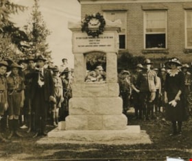
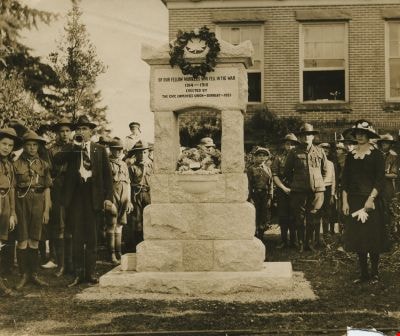
- Photograph of the unveiling the First World War memorial fountain at the Municipal Hall, Kingsway and Edmonds Street, on June 17, 1923. It was dedicated to Municipal employees who died in the War. Engraved at the top of the memorial is "[In memory?] of our fellow workers who fell in the war, 1914…
- Repository
- City of Burnaby Archives
- Date
- June 17, 1923
- Collection/Fonds
- Burnaby Historical Society fonds
- Subseries
- Photographs subseries
- Physical Description
- 1 photograph : b&w ; 15.3 x 18.3 cm
- Description Level
- Item
- Record No.
- 025-001
- Access Restriction
- No restrictions
- Reproduction Restriction
- No known restrictions
- Accession Number
- BHS2007-04
- Scope and Content
- Photograph of the unveiling the First World War memorial fountain at the Municipal Hall, Kingsway and Edmonds Street, on June 17, 1923. It was dedicated to Municipal employees who died in the War. Engraved at the top of the memorial is "[In memory?] of our fellow workers who fell in the war, 1914-1918 / Erected by the Civic Employees Union - Burnaby - 1923." At the right is Dora Wilcox, daughter of Ernest Wilcox who was killed on the Somme in 1916. She unveiled the fountain. Uniformed boys, possibly Boy Scouts, and a bugler are also pictured. In 1974, this memorial was relocated from its original setting to the site of the Burnaby Village Museum on Deer Lake Avenue.
- Media Type
- Photograph
- Notes
- Title based on contents of photograph
- Geographic Access
- Kingsway
- Deer Lake Avenue
- Street Address
- 7282 Kingsway
- 6501 Deer Lake Avenue
- Historic Neighbourhood
- Edmonds (Historic Neighbourhood)
- Burnaby Lake (Historic Neighbourhood)
- Planning Study Area
- Stride Avenue Area
- Morley-Buckingham Area
Images
![Waplington home, [between 1925 and 1958] thumbnail](/media/Hpo/_Data/_BVM_Images/2016/2016_0046_0078_001.jpg?width=280)
Waplington home
https://search.heritageburnaby.ca/link/museumdescription5122
- Repository
- Burnaby Village Museum
- Date
- [between 1925 and 1958]
- Collection/Fonds
- Waplington family fonds
- Description Level
- Item
- Physical Description
- 1 photograph : b&w ; 5.5 x 8 cm
- Scope and Content
- Photograph of Waplington family home located at 3813 Deer Lake. The house was called 'Brookfield' when it was formerly owned by Claude Hill. The house was purchased by Jack and Sarah Waplington in 1925. Jack and Sarah raised there three children (Frances, John and Grace) in the house until they ret…
- Repository
- Burnaby Village Museum
- Collection/Fonds
- Waplington family fonds
- Description Level
- Item
- Physical Description
- 1 photograph : b&w ; 5.5 x 8 cm
- Scope and Content
- Photograph of Waplington family home located at 3813 Deer Lake. The house was called 'Brookfield' when it was formerly owned by Claude Hill. The house was purchased by Jack and Sarah Waplington in 1925. Jack and Sarah raised there three children (Frances, John and Grace) in the house until they retired to Lasqueti Island in 1946. They sold the house to their eldest daughter, Frances and son in law Ray Fleming who lived in the home until 1958. The house and property was sold to the Municipality of Burnaby in 1959.
- Geographic Access
- Deer Lake Avenue
- Street Address
- 3813 Deer Lake Avenue
- Accession Code
- BV016.46.78
- Access Restriction
- No restrictions
- Reproduction Restriction
- No known restrictions
- Date
- [between 1925 and 1958]
- Media Type
- Photograph
- Historic Neighbourhood
- Burnaby Lake (Historic Neighbourhood)
- Planning Study Area
- Morley-Buckingham Area
- Scan Resolution
- 600
- Scan Date
- 13-Aug-2018
- Notes
- Title based on contents of photograph
- Photograph is part of Photograph album BV016.46.52
Images
![Waplington home, [between 1925 and 1958] thumbnail](/media/Hpo/_Data/_BVM_Images/2016/2016_0046_0078_001.jpg)
![Waplingtons and Rita Nickerson, [between 1926 and 1927] thumbnail](/media/Hpo/_Data/_BVM_Images/2016/2016_0046_0072_001.jpg?width=280)
Waplingtons and Rita Nickerson
https://search.heritageburnaby.ca/link/museumdescription5101
- Repository
- Burnaby Village Museum
- Date
- [between 1926 and 1927]
- Collection/Fonds
- Waplington family fonds
- Description Level
- Item
- Physical Description
- 1 photograph : b&w ; 9.5 x 13 cm
- Scope and Content
- Photograph of Sarah Waplington, Rita Nickerson (standing), John Waplington, Grace Waplington with cousin Frannie and Frances Waplington gathered together outside the Waplington home.
- Repository
- Burnaby Village Museum
- Collection/Fonds
- Waplington family fonds
- Description Level
- Item
- Physical Description
- 1 photograph : b&w ; 9.5 x 13 cm
- Scope and Content
- Photograph of Sarah Waplington, Rita Nickerson (standing), John Waplington, Grace Waplington with cousin Frannie and Frances Waplington gathered together outside the Waplington home.
- Names
- Waplington, Sarah Alice Cogswell Nickerson "Cutie"
- Fleming, Frances "Fanny" Waplington
- Waplington, Grace
- Waplington, John
- Nickerson, Rita
- Geographic Access
- Deer Lake Avenue
- Street Address
- 3813 Deer Lake Avenue
- Accession Code
- BV016.46.72
- Access Restriction
- No restrictions
- Reproduction Restriction
- No known restrictions
- Date
- [between 1926 and 1927]
- Media Type
- Photograph
- Historic Neighbourhood
- Burnaby Lake (Historic Neighbourhood)
- Planning Study Area
- Morley-Buckingham Area
- Scan Resolution
- 600
- Scan Date
- 13-Aug-2018
- Notes
- Title based on contents of photograph gathered from page of album
- Photograph is part of Photograph album BV016.46.52
Images
![Waplingtons and Rita Nickerson, [between 1926 and 1927] thumbnail](/media/Hpo/_Data/_BVM_Images/2016/2016_0046_0072_001.jpg)
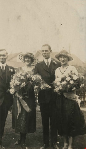
The wedding party
https://search.heritageburnaby.ca/link/archivedescription39283
- Repository
- City of Burnaby Archives
- Date
- August 7, 1922
- Collection/Fonds
- Peers Family and Hill Family fonds
- Description Level
- Item
- Physical Description
- 1 photograph : b&w ; 6 x 10.5 cm on page 24.5 x 32.5 cm (pasted in album)
- Scope and Content
- Photograph of (l to r): unidentified man, Florence Hart, Harold Godwin and Kitty Hill. Florence Hart was the daughter of Frederick J. and Alice Hart and she married Harold Godwin. Kitty Hill was a member of the wedding party. This photograph was taken on the grounds of the Hart House.
- Repository
- City of Burnaby Archives
- Date
- August 7, 1922
- Collection/Fonds
- Peers Family and Hill Family fonds
- Physical Description
- 1 photograph : b&w ; 6 x 10.5 cm on page 24.5 x 32.5 cm (pasted in album)
- Description Level
- Item
- Record No.
- 477-602
- Access Restriction
- No restrictions
- Reproduction Restriction
- No known restrictions
- Accession Number
- 2007-12
- Scope and Content
- Photograph of (l to r): unidentified man, Florence Hart, Harold Godwin and Kitty Hill. Florence Hart was the daughter of Frederick J. and Alice Hart and she married Harold Godwin. Kitty Hill was a member of the wedding party. This photograph was taken on the grounds of the Hart House.
- Subjects
- Ceremonies - Weddings
- Media Type
- Photograph
- Notes
- Title based on caption accompanying photograph
- Geographic Access
- Deer Lake Avenue
- Street Address
- 6664 Deer Lake Avenue
- Historic Neighbourhood
- Burnaby Lake (Historic Neighbourhood)
- Planning Study Area
- Morley-Buckingham Area
Images
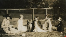
Women seated next to a tennis court
https://search.heritageburnaby.ca/link/archivedescription39218
- Repository
- City of Burnaby Archives
- Date
- 1926
- Collection/Fonds
- Peers Family and Hill Family fonds
- Description Level
- Item
- Physical Description
- 1 photograph : sepia ; 6 x 11 cm on page 24.5 x 32.5 cm (pasted in album)
- Scope and Content
- Photograph of six women seated next to the tennis court at the home of Bob and Kitty Peers family on Deer Lake Avenue. All are unidentified.
- Repository
- City of Burnaby Archives
- Date
- 1926
- Collection/Fonds
- Peers Family and Hill Family fonds
- Physical Description
- 1 photograph : sepia ; 6 x 11 cm on page 24.5 x 32.5 cm (pasted in album)
- Description Level
- Item
- Record No.
- 477-537
- Access Restriction
- No restrictions
- Reproduction Restriction
- No known restrictions
- Accession Number
- 2007-12
- Scope and Content
- Photograph of six women seated next to the tennis court at the home of Bob and Kitty Peers family on Deer Lake Avenue. All are unidentified.
- Subjects
- Sports - Tennis
- Media Type
- Photograph
- Notes
- Title based on caption accompanying photograph
- Geographic Access
- Deer Lake Avenue
- Street Address
- 6588 Deer Lake Avenue
- Historic Neighbourhood
- Burnaby Lake (Historic Neighbourhood)
- Planning Study Area
- Douglas-Gilpin Area
Images

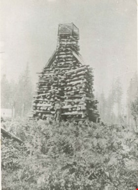
Wood stacked for a bonfire
https://search.heritageburnaby.ca/link/archivedescription35910
- Repository
- City of Burnaby Archives
- Date
- 1897 (date of original), copied 1986
- Collection/Fonds
- Burnaby Historical Society fonds
- Description Level
- Item
- Physical Description
- 1 photograph : b&w ; 12.7 x 17.8 cm print
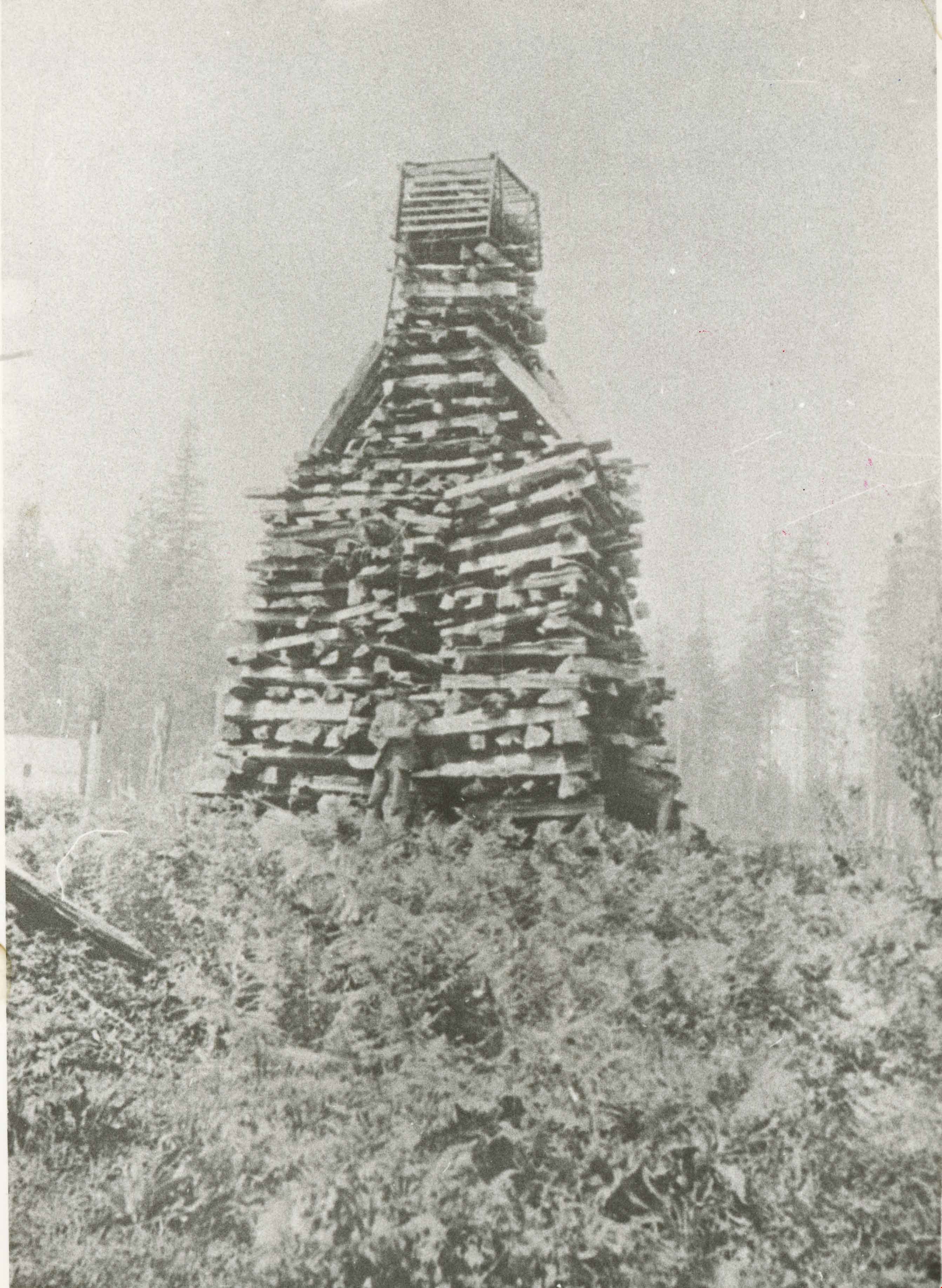
- Scope and Content
- Photograph of a structure prepared by Claude Hill for a bonfire at Deer Lake celebrating Queen Victoria's Jubilee. The bonfire could be seen for miles around.
- Repository
- City of Burnaby Archives
- Date
- 1897 (date of original), copied 1986
- Collection/Fonds
- Burnaby Historical Society fonds
- Subseries
- Pioneer Tales subseries
- Physical Description
- 1 photograph : b&w ; 12.7 x 17.8 cm print
- Description Level
- Item
- Record No.
- 204-769
- Access Restriction
- No restrictions
- Reproduction Restriction
- No known restrictions
- Accession Number
- BHS1988-03
- Scope and Content
- Photograph of a structure prepared by Claude Hill for a bonfire at Deer Lake celebrating Queen Victoria's Jubilee. The bonfire could be seen for miles around.
- Subjects
- Celebrations - Jubilee
- Media Type
- Photograph
- Notes
- Title based on contents of photograph
- Geographic Access
- Deer Lake Avenue
- Street Address
- 6501 Deer Lake Avenue
- Historic Neighbourhood
- Burnaby Lake (Historic Neighbourhood)
- Planning Study Area
- Morley-Buckingham Area
Images
Wood stacked for a bonfire
https://search.heritageburnaby.ca/link/archivedescription38852
- Repository
- City of Burnaby Archives
- Date
- 1897
- Collection/Fonds
- Peers Family and Hill Family fonds
- Description Level
- Item
- Physical Description
- 1 photograph : b&w ; 8.5 x 11 cm
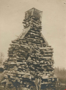
- Scope and Content
- Photograph of Claude Hill standing in front of the log pile that he built for a bonfire celebrating Queen Victoria's Diamond jubilee in 1897. The location is near Deer Lake and it was said that the flames from the fire could be seen for miles.
- Repository
- City of Burnaby Archives
- Date
- 1897
- Collection/Fonds
- Peers Family and Hill Family fonds
- Physical Description
- 1 photograph : b&w ; 8.5 x 11 cm
- Description Level
- Item
- Record No.
- 477-171
- Access Restriction
- No restrictions
- Reproduction Restriction
- No known restrictions
- Accession Number
- 2007-12
- Scope and Content
- Photograph of Claude Hill standing in front of the log pile that he built for a bonfire celebrating Queen Victoria's Diamond jubilee in 1897. The location is near Deer Lake and it was said that the flames from the fire could be seen for miles.
- Subjects
- Celebrations - Jubilee
- Media Type
- Photograph
- Notes
- Title based on contents of photograph
- Historic Neighbourhood
- Burnaby Lake (Historic Neighbourhood)
Images
Wood stacked for a bonfire
https://search.heritageburnaby.ca/link/archivedescription39528
- Repository
- City of Burnaby Archives
- Date
- 1897
- Collection/Fonds
- Peers Family and Hill Family fonds
- Description Level
- Item
- Physical Description
- 1 photograph : b&w ; 7 x 9.5 cm on page 21.5 x 28 cm (pasted in album)
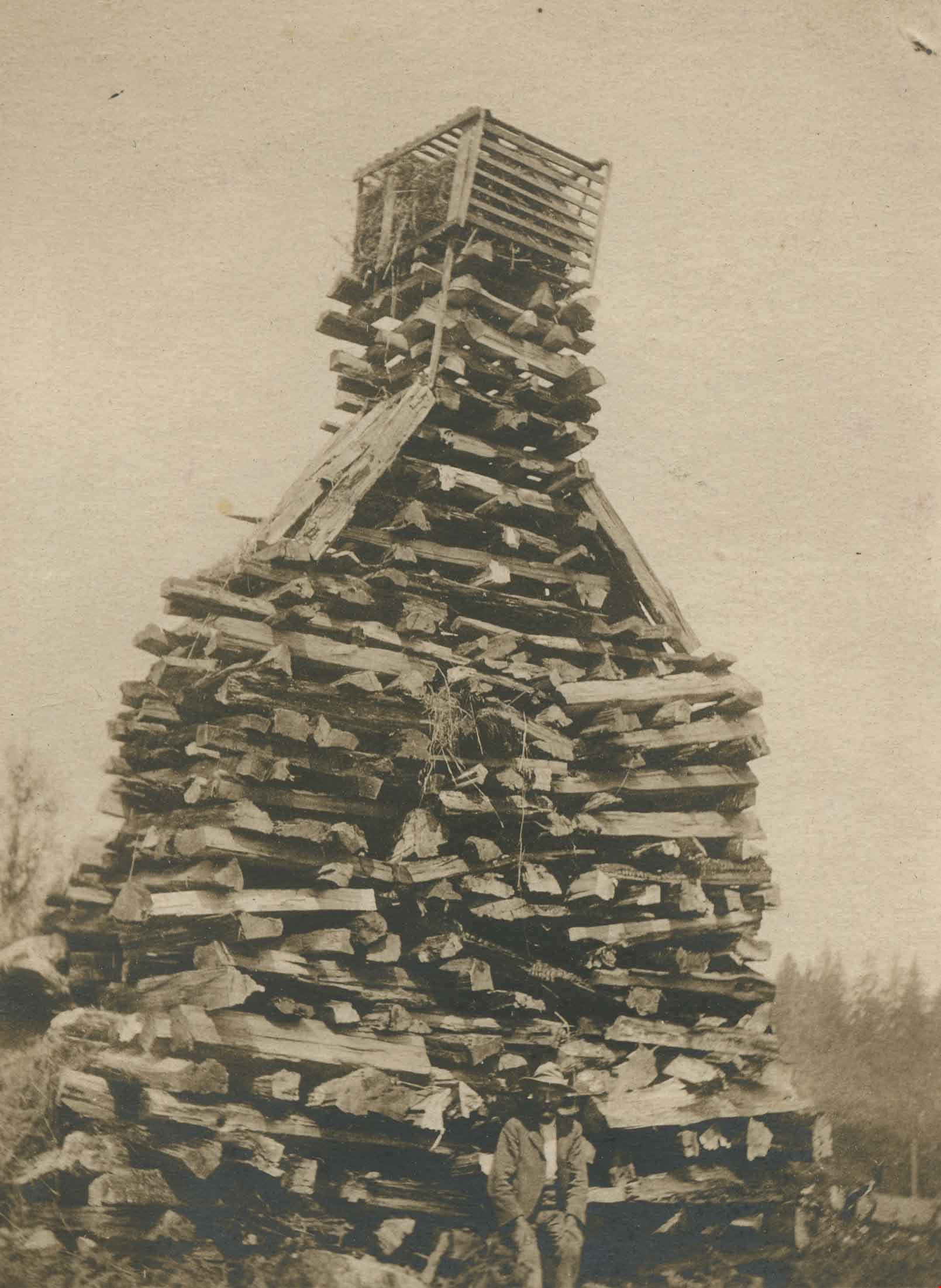
- Scope and Content
- Photograph of a large stack of wood, piled up to create a pyre for a bonfire celebrating Queen Victoria's Diamond Jubilee in June, 1897. Claude Hill built this structure near Deer Lake and it was reported that when lit, the fire could be seen for miles.
- Repository
- City of Burnaby Archives
- Date
- 1897
- Collection/Fonds
- Peers Family and Hill Family fonds
- Physical Description
- 1 photograph : b&w ; 7 x 9.5 cm on page 21.5 x 28 cm (pasted in album)
- Description Level
- Item
- Record No.
- 477-847
- Access Restriction
- No restrictions
- Reproduction Restriction
- No known restrictions
- Accession Number
- 2007-12
- Scope and Content
- Photograph of a large stack of wood, piled up to create a pyre for a bonfire celebrating Queen Victoria's Diamond Jubilee in June, 1897. Claude Hill built this structure near Deer Lake and it was reported that when lit, the fire could be seen for miles.
- Subjects
- Celebrations - Jubilee
- Media Type
- Photograph
- Notes
- Title based on contents of photograph
- Geographic Access
- Deer Lake
- Historic Neighbourhood
- Burnaby Lake (Historic Neighbourhood)
Images
