Narrow Results By
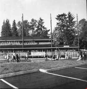
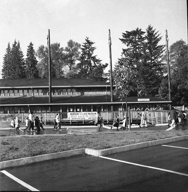
Adminstration building and entrance to Burnaby Village Museum
https://search.heritageburnaby.ca/link/museumdescription17505
- Repository
- Burnaby Village Museum
- Date
- 1990
- Collection/Fonds
- Burnaby Village Museum fonds
- Description Level
- Item
- Physical Description
- 1 photograph : b&w negative ; 6 x 6 cm
- Scope and Content
- Photograph of Burnaby Village Museum adminstration building, parking lot and entrance. A group of visitors are walking through the parking lot towards the entrance.
- Repository
- Burnaby Village Museum
- Collection/Fonds
- Burnaby Village Museum fonds
- Series
- Museum photographs series
- Description Level
- Item
- Physical Description
- 1 photograph : b&w negative ; 6 x 6 cm
- Scope and Content
- Photograph of Burnaby Village Museum adminstration building, parking lot and entrance. A group of visitors are walking through the parking lot towards the entrance.
- Subjects
- Buildings - Civic - Museums
- Names
- Burnaby Village Museum
- Geographic Access
- Deer Lake Avenue
- Street Address
- 6501 Deer Lake Avenue
- Accession Code
- BV019.2.66
- Access Restriction
- No restrictions
- Reproduction Restriction
- No known restrictions
- Date
- 1990
- Media Type
- Photograph
- Historic Neighbourhood
- Burnaby Lake (Historic Neighbourhood)
- Scan Resolution
- 1200
- Scan Date
- 2021-09-29
- Photographer
- Stevens, Colin
- Notes
- Title based on contents of photograph
- Photograph from negative roll "P90-19"
Images
![Antique cars on Hill Street, [198-] thumbnail](/media/hpo/_Data/_BVM_Images/2020/2020_0005_0934_001.jpg?width=280)
Antique cars on Hill Street
https://search.heritageburnaby.ca/link/museumdescription13743
- Repository
- Burnaby Village Museum
- Date
- [198-]
- Collection/Fonds
- Century Park Museum Association fonds
- Description Level
- Item
- Physical Description
- 1 photograph : col. ; 10 x 15 cm
- Scope and Content
- Photograph of Hill Street inside Heritage Village Museum. Visitors are gathered along the street to view antique cars and buildings are decorated with red, white and blue bunting.
- Repository
- Burnaby Village Museum
- Collection/Fonds
- Century Park Museum Association fonds
- Description Level
- Item
- Physical Description
- 1 photograph : col. ; 10 x 15 cm
- Scope and Content
- Photograph of Hill Street inside Heritage Village Museum. Visitors are gathered along the street to view antique cars and buildings are decorated with red, white and blue bunting.
- Names
- Burnaby Village Museum
- Geographic Access
- Deer Lake Avenue
- Accession Code
- BV020.5.934
- Access Restriction
- No restrictions
- Reproduction Restriction
- No known restrictions
- Date
- [198-]
- Media Type
- Photograph
- Historic Neighbourhood
- Burnaby Lake (Historic Neighbourhood)
- Planning Study Area
- Morley-Buckingham Area
- Scan Resolution
- 600
- Scan Date
- 22-Sep-2020
- Scale
- 100
- Notes
- Title based on contents of photograph
Images
![Antique cars on Hill Street, [198-] thumbnail](/media/hpo/_Data/_BVM_Images/2020/2020_0005_0934_001.jpg)

Barn, paddock and out buildings
https://search.heritageburnaby.ca/link/museumdescription12818
- Repository
- Burnaby Village Museum
- Date
- 1977
- Collection/Fonds
- Century Park Museum Association fonds
- Description Level
- Item
- Physical Description
- 1 photograph : col. slide ; 35 mm
- Scope and Content
- Photograph of the barn, fenced paddocks and out buildings on the Lubbock family farm located at 7803 Burris Street.
- Repository
- Burnaby Village Museum
- Collection/Fonds
- Century Park Museum Association fonds
- Description Level
- Item
- Physical Description
- 1 photograph : col. slide ; 35 mm
- Scope and Content
- Photograph of the barn, fenced paddocks and out buildings on the Lubbock family farm located at 7803 Burris Street.
- History
- In 1977, Century Park Museum was granted access to the Sprott-Lubbock farm to appraise the heritage buildings for preservation. Buildings that were saved included the old farrier shed (BV985.1240.2) which was also used as a blacksmith shop and the Vorce tram station building (BV985.1240.3) from the old Burnaby Lake Interurban line which was used as a grain storage shed on the property. Segments of the original farmhouse and other out buildings were retained. Other buildings on the site were demolished to make way for a new housing development.
- Subjects
- Agriculture - Farms
- Names
- Lubbock farm
- Geographic Access
- Grandview Highway
- Burris Street
- Street Address
- 7803 Burris Street
- Accession Code
- BV020.5.485
- Access Restriction
- No restrictions
- Reproduction Restriction
- No known restrictions
- Date
- 1977
- Media Type
- Photograph
- Historic Neighbourhood
- Burnaby Lake (Historic Neighbourhood)
- Planning Study Area
- Morley-Buckingham Area
- Scan Resolution
- 2400
- Scan Date
- 13-Mar-20
- Scale
- 100
- Notes
- Title based on contents of photograph
Images

![Bateman gardens, [192-] thumbnail](/media/hpo/_Data/_BVM_Images/1976/1976_0037_0003_001.jpg?width=280)
Bateman gardens
https://search.heritageburnaby.ca/link/museumdescription678
- Repository
- Burnaby Village Museum
- Date
- [192-]
- Collection/Fonds
- E.W. Bateman family fonds
- Description Level
- Item
- Physical Description
- 1 photograph : b&w ; 9.1 x 13.8 cm
- Scope and Content
- Photograph of the Batemen family gardens. Edwin W. and Mary Batemen built their house, "Elworth," as a retirement home. It is located at the site of what would become Burnaby Village Museum, 6501 Deer Lake Avenue. Three unidentified people are standing on the far side of a gravel path laid out in …
- Repository
- Burnaby Village Museum
- Collection/Fonds
- E.W. Bateman family fonds
- Description Level
- Item
- Physical Description
- 1 photograph : b&w ; 9.1 x 13.8 cm
- Scope and Content
- Photograph of the Batemen family gardens. Edwin W. and Mary Batemen built their house, "Elworth," as a retirement home. It is located at the site of what would become Burnaby Village Museum, 6501 Deer Lake Avenue. Three unidentified people are standing on the far side of a gravel path laid out in the garden. A shed and a small cottage can be seen also.
- Subjects
- Geographic Features - Gardens
- Geographic Access
- Deer Lake Avenue
- Street Address
- 6501 Deer Lake Avenue
- Accession Code
- HV976.37.3
- Access Restriction
- No restrictions
- Reproduction Restriction
- No known restrictions
- Date
- [192-]
- Media Type
- Photograph
- Historic Neighbourhood
- Burnaby Lake (Historic Neighbourhood)
- Planning Study Area
- Morley-Buckingham Area
- Scan Resolution
- 600
- Scan Date
- 2023-06-13
- Notes
- Title based on contents of photograph
Images
![Bateman gardens, [192-] thumbnail](/media/hpo/_Data/_BVM_Images/1976/1976_0037_0003_001.jpg)
![Bateman gardens, [192-] thumbnail](/media/hpo/_Data/_BVM_Images/1976/1976_0037_0004_001.jpg?width=280)
Bateman gardens
https://search.heritageburnaby.ca/link/museumdescription679
- Repository
- Burnaby Village Museum
- Date
- [192-]
- Collection/Fonds
- E.W. Bateman family fonds
- Description Level
- Item
- Physical Description
- 1 photograph : b&w ; 9.1 x 13.8 cm
- Scope and Content
- Photograph of the Batemen family gardens. Edwin W. and Mary Batemen built their house, "Elworth," as a retirement home. It is located at the site of what would become Burnaby Village Museum, 6501 Deer Lake Avenue. A view is seen looking out towards the entrance into the garden and the road runnin…
- Repository
- Burnaby Village Museum
- Collection/Fonds
- E.W. Bateman family fonds
- Description Level
- Item
- Physical Description
- 1 photograph : b&w ; 9.1 x 13.8 cm
- Scope and Content
- Photograph of the Batemen family gardens. Edwin W. and Mary Batemen built their house, "Elworth," as a retirement home. It is located at the site of what would become Burnaby Village Museum, 6501 Deer Lake Avenue. A view is seen looking out towards the entrance into the garden and the road running across just outside of the gardens. Power poles can be seen along the road, and a greenhouse can be seen on a different plot of land across the street.
- Subjects
- Geographic Features - Gardens
- Geographic Access
- Deer Lake Avenue
- Street Address
- 6501 Deer Lake Avenue
- Accession Code
- HV976.37.4
- Access Restriction
- No restrictions
- Reproduction Restriction
- No known restrictions
- Date
- [192-]
- Media Type
- Photograph
- Historic Neighbourhood
- Burnaby Lake (Historic Neighbourhood)
- Planning Study Area
- Morley-Buckingham Area
- Scan Resolution
- 600
- Scan Date
- 2023-06-13
- Notes
- Title based on contents of photograph
Images
![Bateman gardens, [192-] thumbnail](/media/hpo/_Data/_BVM_Images/1976/1976_0037_0004_001.jpg)
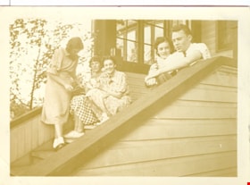
Bea, Elieen, Kay, Wilma and Colin
https://search.heritageburnaby.ca/link/museumdescription2710
- Repository
- Burnaby Village Museum
- Date
- July 24, 1937
- Collection/Fonds
- Hawkshaw family fonds
- Description Level
- Item
- Physical Description
- 1 photograph : sepia ; 5.5 x 8 cm
- Scope and Content
- Photograph of Bea, Eileen, Kay, Wilma and Colin sitting and standing together on the front steps of the Hawkshaw home located at 3908 Deer Lake Avenue (R.F. Anderson house - 6504 Deer Lake Avenue).
- Repository
- Burnaby Village Museum
- Collection/Fonds
- Hawkshaw family fonds
- Description Level
- Item
- Physical Description
- 1 photograph : sepia ; 5.5 x 8 cm
- Scope and Content
- Photograph of Bea, Eileen, Kay, Wilma and Colin sitting and standing together on the front steps of the Hawkshaw home located at 3908 Deer Lake Avenue (R.F. Anderson house - 6504 Deer Lake Avenue).
- Geographic Access
- Deer Lake Avenue
- Accession Code
- BV996.6.151
- Access Restriction
- No restrictions
- Reproduction Restriction
- No known restrictions
- Date
- July 24, 1937
- Media Type
- Photograph
- Historic Neighbourhood
- Burnaby Lake (Historic Neighbourhood)
- Planning Study Area
- Morley-Buckingham Area
- Scan Resolution
- 600
- Scan Date
- 2/18/2010
- Scale
- 100
- Notes
- Title based on contents of photograph
- Caption for photograph reads: "Bea, Eileen Kay Wilma Colin"
- Note in pencil on verso of photograph reads: "July 24/37"
- Photograph is part of photograph album BV996.6.1
Images


Bird's Eye View of the Burnaby Lake Area
https://search.heritageburnaby.ca/link/museumdescription15144
- Repository
- Burnaby Village Museum
- Date
- 1977
- Collection/Fonds
- Century Park Museum Association fonds
- Description Level
- Item
- Physical Description
- 1 map : b&w print on paper ; 43 x 63.5 cm
- Scope and Content
- Item consists of a map titled "Birds Eye View of the Burnaby Lake Area Circa 1910". The overview of the Burnaby Lake area was compiled and drawn at Heritage Village by curator John Adams and artist, Carol Swan. The map identifies the Burnaby Lake inter-urban tram line; roads including: Sperling Ave…
- Repository
- Burnaby Village Museum
- Collection/Fonds
- Century Park Museum Association fonds
- Description Level
- Item
- Physical Description
- 1 map : b&w print on paper ; 43 x 63.5 cm
- Material Details
- Scale indeterminable
- Scope and Content
- Item consists of a map titled "Birds Eye View of the Burnaby Lake Area Circa 1910". The overview of the Burnaby Lake area was compiled and drawn at Heritage Village by curator John Adams and artist, Carol Swan. The map identifies the Burnaby Lake inter-urban tram line; roads including: Sperling Avenue (Pole Line Road); Gilpin Avenue; Douglas Road; trail to Vancouver Westminster Road (Kingsway); Buckingham Avenue; Haszard Street; various farms and residences including: Charles Sprott "Norland"; H.T. Ceperley "Fairacres"; Claude Hill's "Brookfield farm" and "Broadview"; F.J. Hart's "Avalon"; Miss Woodward's former and new home, school and post office; Councillor Edgar's hunting cabin; Edgar Sprott's "Mayfield farm" and "Mayfield Lodge"; F.J. Peers "Greyfriars"; Arthur de Windt Haszard; Bernard Hill's boathouse as well as other landmarks including: Doran's Mill; tram stations; Burnaby Lake Store; logging camps; wood cutter's shacks; ice houses; cranberry bog; Still Creek; Deer Lake; Burnaby Lake; Deer Lake Creek; Provincial Government Reserve Proposed Hospital (later Oakalla Prison).
- Creator
- Adams, John
- Swan, Carol
- Names
- Hill, Arthur Claude
- Sprott, Charles Frederick
- Sprott, Louis "Edgar"
- Hart, Frederick John, 1884-1945
- Ceperley, H.T.
- Woodward, Maude
- Woodward, Harriet
- Peers, Francis J.
- Haszard, Arthur de Windt
- Hill, Bernard R.
- Geographic Access
- Deer Lake Avenue
- Sperling Avenue
- Haszard Street
- Buckingham Avenue
- Accession Code
- BV021.1.3
- Access Restriction
- No restrictions
- Reproduction Restriction
- No known restrictions
- Date
- 1977
- Media Type
- Cartographic Material
- Historic Neighbourhood
- Burnaby Lake (Historic Neighbourhood)
- Planning Study Area
- Burnaby Lake Area
- Related Material
- See also: Life with the Moores of Hart House : pioneer days on Burnaby's Deer Lake
- Scan Resolution
- 600
- Scan Date
- 2021-11-12
- Scale
- 100
- Notes
- Transcribed title
- Compiled by John Adams; illustration by Carol Swan
- The map depicts the Burnaby Lake Tram Line as being double tracked, whereas in reality it was single tracked.
- Map is part of the book "Life with the Moores of Hart House : pioneer days on Burnaby's Deer Lake https://search.heritageburnaby.ca/permalink/museumlibrary6314-102
Images


Bird's Eye View of the Burnaby Lake Area
https://search.heritageburnaby.ca/link/museumdescription17543
- Repository
- Burnaby Village Museum
- Date
- 1977
- Collection/Fonds
- Century Park Museum Association fonds
- Description Level
- Item
- Physical Description
- 1 map : b&w print with watercolour ; 43 x 63.5 cm
- Scope and Content
- Item consists of a map titled "Birds Eye View of the Burnaby Lake Area Circa 1910". The overview of the Burnaby Lake area was compiled and drawn at Heritage Village by curator John Adams and artist, Carol Swan. The map identifies the Burnaby Lake inter-urban tram line; roads including: Sperling Ave…
- Repository
- Burnaby Village Museum
- Collection/Fonds
- Century Park Museum Association fonds
- Description Level
- Item
- Physical Description
- 1 map : b&w print with watercolour ; 43 x 63.5 cm
- Material Details
- Scale indeterminable
- Scope and Content
- Item consists of a map titled "Birds Eye View of the Burnaby Lake Area Circa 1910". The overview of the Burnaby Lake area was compiled and drawn at Heritage Village by curator John Adams and artist, Carol Swan. The map identifies the Burnaby Lake inter-urban tram line; roads including: Sperling Avenue (Pole Line Road); Gilpin Avenue; Douglas Road; trail to Vancouver Westminster Road (Kingsway); Buckingham Avenue; Haszard Street; various farms and residences including: Charles Sprott "Norland"; H.T. Ceperley "Fairacres"; Claude Hill's "Brookfield farm" and "Broadview"; F.J. Hart's "Avalon"; Miss Woodward's former and new home, school and post office; Councillor Edgar's hunting cabin; Edgar Sprott's "Mayfield farm" and "Mayfield Lodge"; F.J. Peers "Greyfriars"; Arthur de Windt Haszard; Bernard Hill's boathouse as well as other landmarks including: Doran's Mill; tram stations; Burnaby Lake Store; logging camps; wood cutter's shacks; ice houses; cranberry bog; Still Creek; Deer Lake; Burnaby Lake; Deer Lake Creek; Provincial Government Reserve Proposed Hospital (later Oakalla Prison).
- Creator
- Adams, John
- Swan, Carol
- Names
- Hill, Arthur Claude
- Sprott, Charles Frederick
- Sprott, Louis "Edgar"
- Hart, Frederick John, 1884-1945
- Ceperley, H.T.
- Woodward, Maude
- Woodward, Harriet
- Peers, Francis J.
- Haszard, Arthur de Windt
- Hill, Bernard R.
- Geographic Access
- Deer Lake Avenue
- Sperling Avenue
- Haszard Street
- Buckingham Avenue
- Accession Code
- BV021.1.4
- Access Restriction
- No restrictions
- Reproduction Restriction
- No known restrictions
- Date
- 1977
- Media Type
- Cartographic Material
- Historic Neighbourhood
- Burnaby Lake (Historic Neighbourhood)
- Planning Study Area
- Burnaby Lake Area
- Related Material
- See also: Life with the Moores of Hart House : pioneer days on Burnaby's Deer Lake
- Scan Resolution
- 600
- Scan Date
- 2021-11-12
- Scale
- 100
- Notes
- Transcribed title
- Compiled by John Adams; illustration by Carol Swan
- The map depicts the Burnaby Lake Tram Line as being double tracked, whereas in reality it was single tracked.
- Map is part of the book "Life with the Moores of Hart House : pioneer days on Burnaby's Deer Lake https://search.heritageburnaby.ca/permalink/museumlibrary6314-102
- This is a print made from original illustration and appears to be hand-coloured with watercolour at a later date.
Images

![Brookfield, [1900] thumbnail](/media/hpo/_Data/_BVM_Images/1976/1976_0139_0005_001.jpg?width=280)
Brookfield
https://search.heritageburnaby.ca/link/museumdescription754
- Repository
- Burnaby Village Museum
- Date
- [1900]
- Collection/Fonds
- Burnaby Village Museum Photograph collection
- Description Level
- Item
- Physical Description
- 1 photograph : b&w ; 9.9 x 14.0 cm mounted on cardboard 17.8 x 23.0 cm
- Scope and Content
- Photograph of "Brookfield", the first home of Mr. and Mrs. Louis Claude Hill. The Hills, including the daughter Kitty Hill, are on the lawn on the lower right corner. The man sitting on the steps is identified by the inscription on the photograph card mount as Mr. Wetenhall. Annotations on the back…
- Repository
- Burnaby Village Museum
- Collection/Fonds
- Burnaby Village Museum Photograph collection
- Description Level
- Item
- Physical Description
- 1 photograph : b&w ; 9.9 x 14.0 cm mounted on cardboard 17.8 x 23.0 cm
- Scope and Content
- Photograph of "Brookfield", the first home of Mr. and Mrs. Louis Claude Hill. The Hills, including the daughter Kitty Hill, are on the lawn on the lower right corner. The man sitting on the steps is identified by the inscription on the photograph card mount as Mr. Wetenhall. Annotations on the back of the card read: "'Brookfield' / Burnaby Lake" and "L.C. Hill & Kitty M. Hill, Mr. Wetenhall." Another annotation reads: "App. 1900."
- Subjects
- Buildings - Residential - Houses
- Geographic Access
- Deer Lake Avenue
- Street Address
- 6501 Deer Lake Avenue
- Accession Code
- HV976.139.5
- Access Restriction
- No restrictions
- Reproduction Restriction
- No known restrictions
- Date
- [1900]
- Media Type
- Photograph
- Historic Neighbourhood
- Burnaby Lake (Historic Neighbourhood)
- Planning Study Area
- Morley-Buckingham Area
- Related Material
- For another view of Brookfield home, see HV976.139.53
- Scan Resolution
- 600
- Scan Date
- 2023-06-27
- Notes
- Title based on contents of photograph
Images
![Brookfield, [1900] thumbnail](/media/hpo/_Data/_BVM_Images/1976/1976_0139_0005_001.jpg)

![Brookfield, [1896] thumbnail](/media/hpo/_Data/_BVM_Images/1973/1973_0040_0001_001.jpg?width=280)
Brookfield
https://search.heritageburnaby.ca/link/museumdescription988
- Repository
- Burnaby Village Museum
- Date
- [1896]
- Collection/Fonds
- Burnaby Village Museum Photograph collection
- Description Level
- Item
- Physical Description
- 1 photograph : b&w ; 12.1 x 17.7 cm
- Scope and Content
- Photograph of the house built about 1894 that Louis Claud Hill called "Brookfield." Mr. Hill was married that year to Annie Sara Kendrick, and they took up residence in the house until 1906 when they sold the property and built a new home in the vicinity of Buckingham and Sperling. Brookfield was…
- Repository
- Burnaby Village Museum
- Collection/Fonds
- Burnaby Village Museum Photograph collection
- Description Level
- Item
- Physical Description
- 1 photograph : b&w ; 12.1 x 17.7 cm
- Scope and Content
- Photograph of the house built about 1894 that Louis Claud Hill called "Brookfield." Mr. Hill was married that year to Annie Sara Kendrick, and they took up residence in the house until 1906 when they sold the property and built a new home in the vicinity of Buckingham and Sperling. Brookfield was still on the property when the Burnaby Village Museum was planned in 1971 as Heritage Village, but it was torn down to make room for other buildings on the site. An acquisition record notes that this house stood immediately behind the Elworth House, and Colonel Peers' (the donor) mother was born in this house in 1898. Annotations on the back of the photo read, "1896 'Brookfield'" and "The residence of Mr.+Mrs. LC Hill, the first residence on the site of Heritage Court. It stood immediately behind what is now called the Manor House. Built about 1894."
- Subjects
- Buildings - Residential - Houses
- Geographic Access
- Deer Lake Avenue
- Street Address
- 6501 Deer Lake Avenue
- Accession Code
- HV973.40.1
- Access Restriction
- No restrictions
- Reproduction Restriction
- No known restrictions
- Date
- [1896]
- Media Type
- Photograph
- Historic Neighbourhood
- Burnaby Lake (Historic Neighbourhood)
- Planning Study Area
- Morley-Buckingham Area
- Scan Resolution
- 600
- Scan Date
- 2023-05-09
- Scale
- 100
- Notes
- Title based on contents of photograph
Images
![Brookfield, [1896] thumbnail](/media/hpo/_Data/_BVM_Images/1973/1973_0040_0001_001.jpg)

Buildings on Lubbock farm
https://search.heritageburnaby.ca/link/museumdescription12783
- Repository
- Burnaby Village Museum
- Date
- 1977
- Collection/Fonds
- Century Park Museum Association fonds
- Description Level
- Item
- Physical Description
- 1 photograph : col. slide ; 35 mm
- Scope and Content
- Photograph of the cedar shingled rooftops of the Lubbock barn and out buildings that were located at at 7803 Burris Street near Burnaby Lake. Bushes, trees and tall grasses surround the buildings.
- Repository
- Burnaby Village Museum
- Collection/Fonds
- Century Park Museum Association fonds
- Description Level
- Item
- Physical Description
- 1 photograph : col. slide ; 35 mm
- Scope and Content
- Photograph of the cedar shingled rooftops of the Lubbock barn and out buildings that were located at at 7803 Burris Street near Burnaby Lake. Bushes, trees and tall grasses surround the buildings.
- History
- In 1977, Century Park Museum was granted access to the Sprott-Lubbock farm to appraise the heritage buildings for preservation. Buildings that were saved included the old farrier shed (BV985.1240.2) which was also used as a blacksmith shop and the Vorce tram station building (BV985.1240.3) from the old Burnaby Lake Interurban line which was used as a grain storage shed on the property. Segments of the original farmhouse and other out buildings were retained. Other buildings on the site were demolished to make way for a new housing development.
- Subjects
- Agriculture - Farms
- Names
- Lubbock farm
- Geographic Access
- Grandview Highway
- Burris Street
- Street Address
- 7803 Burris Street
- Accession Code
- BV020.5.460
- Access Restriction
- No restrictions
- Reproduction Restriction
- No known restrictions
- Date
- 1977
- Media Type
- Photograph
- Historic Neighbourhood
- Burnaby Lake (Historic Neighbourhood)
- Planning Study Area
- Morley-Buckingham Area
- Scan Resolution
- 2400
- Scan Date
- 13-Mar-20
- Scale
- 100
- Notes
- Title based on contents of photograph
Images

![Chapel at Fairacres, [between 1939 and 1954] (date of original), copied 1979 thumbnail](/media/hpo/_Data/_BVM_Images/1979/1979_0034_0002_001.jpg?width=280)
Chapel at Fairacres
https://search.heritageburnaby.ca/link/museumdescription1629
- Repository
- Burnaby Village Museum
- Date
- [between 1939 and 1954] (date of original), copied 1979
- Collection/Fonds
- Burnaby Village Museum Photograph collection
- Description Level
- Item
- Physical Description
- 1 photograph : b&w ; 20.3 x 25.2 cm print
- Scope and Content
- Photograph of the chapel of the Order of St. Benedict at the Ceperley Mansion when they purchased and occupied the mansion from 1939 to 1954. They converted the drawing room into a chapel, placing the altar in front of the fireplace. A platform with a cross on a table. The letters "LOCUS ISTE SANCT…
- Repository
- Burnaby Village Museum
- Collection/Fonds
- Burnaby Village Museum Photograph collection
- Description Level
- Item
- Physical Description
- 1 photograph : b&w ; 20.3 x 25.2 cm print
- Scope and Content
- Photograph of the chapel of the Order of St. Benedict at the Ceperley Mansion when they purchased and occupied the mansion from 1939 to 1954. They converted the drawing room into a chapel, placing the altar in front of the fireplace. A platform with a cross on a table. The letters "LOCUS ISTE SANCTUS EST" are inscribed on the wall above the cross. There is a picture of baby Jesus held by the Virgin Mary on one side of the platform, and a Saint holding a baby on the other.
- Names
- Westminster Priory
- Geographic Access
- Deer Lake Avenue
- Street Address
- 6344 Deer Lake Avenue
- Accession Code
- HV979.34.2
- Access Restriction
- Restricted access
- Reproduction Restriction
- May be restricted by third party rights
- Date
- [between 1939 and 1954] (date of original), copied 1979
- Media Type
- Photograph
- Historic Neighbourhood
- Burnaby Lake (Historic Neighbourhood)
- Planning Study Area
- Douglas-Gilpin Area
- Scan Resolution
- 600
- Scan Date
- 2023-09-12
- Notes
- Title based on contents of photograph
Images
![Chapel at Fairacres, [between 1939 and 1954] (date of original), copied 1979 thumbnail](/media/hpo/_Data/_BVM_Images/1979/1979_0034_0002_001.jpg)

Chicken coop building
https://search.heritageburnaby.ca/link/museumdescription12796
- Repository
- Burnaby Village Museum
- Date
- 1977
- Collection/Fonds
- Century Park Museum Association fonds
- Description Level
- Item
- Physical Description
- 1 photograph : col. slide ; 35 mm
- Scope and Content
- Photograph of a building that was used as a chicken coop on the Lubbock farm located at 7803 Burris Street near Burnaby Lake.
- Repository
- Burnaby Village Museum
- Collection/Fonds
- Century Park Museum Association fonds
- Description Level
- Item
- Physical Description
- 1 photograph : col. slide ; 35 mm
- Scope and Content
- Photograph of a building that was used as a chicken coop on the Lubbock farm located at 7803 Burris Street near Burnaby Lake.
- History
- In 1977, Century Park Museum was granted access to the Sprott-Lubbock farm to appraise the heritage buildings for preservation. Buildings that were saved included the old farrier shed (BV985.1240.2) which was also used as a blacksmith shop and the Vorce tram station building (BV985.1240.3) from the old Burnaby Lake Interurban line which was used as a grain storage shed on the property. Segments of the original farmhouse and other out buildings were retained. Other buildings on the site were demolished to make way for a new housing development.
- Subjects
- Agriculture - Farms
- Names
- Lubbock farm
- Geographic Access
- Grandview Highway
- Burris Street
- Street Address
- 7803 Burris Street
- Accession Code
- BV020.5.473
- Access Restriction
- No restrictions
- Reproduction Restriction
- No known restrictions
- Date
- 1977
- Media Type
- Photograph
- Historic Neighbourhood
- Burnaby Lake (Historic Neighbourhood)
- Planning Study Area
- Morley-Buckingham Area
- Scan Resolution
- 2400
- Scan Date
- 13-Mar-20
- Scale
- 100
- Notes
- Title based on contents of photograph
Images

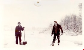
Clearing rink on Deer Lake
https://search.heritageburnaby.ca/link/museumdescription5095
- Repository
- Burnaby Village Museum
- Date
- 1933
- Collection/Fonds
- Waplington family fonds
- Description Level
- Item
- Physical Description
- 1 photograph : b&w ; 7.5 x 12.3 cm
- Scope and Content
- Photograph Jack Waplington and an unidentifed man clearing snow off of Deer Lake for a skating rink.
- Repository
- Burnaby Village Museum
- Collection/Fonds
- Waplington family fonds
- Description Level
- Item
- Physical Description
- 1 photograph : b&w ; 7.5 x 12.3 cm
- Scope and Content
- Photograph Jack Waplington and an unidentifed man clearing snow off of Deer Lake for a skating rink.
- Subjects
- Natural Phenomena - Snow
- Names
- Waplington, John "Jack"
- Geographic Access
- Deer Lake Avenue
- Street Address
- 3813 Deer Lake Avenue
- Accession Code
- BV016.46.66
- Access Restriction
- No restrictions
- Reproduction Restriction
- No known restrictions
- Date
- 1933
- Media Type
- Photograph
- Historic Neighbourhood
- Burnaby Lake (Historic Neighbourhood)
- Planning Study Area
- Morley-Buckingham Area
- Scan Resolution
- 600
- Scan Date
- 13-Aug-2018
- Notes
- Title based on contents of photograph gathered from page of album
- Photograph is part of Photograph album BV016.46.52
Images

![Construction of Elworth, [1922] thumbnail](/media/hpo/_Data/_BVM_Images/1976/1976_0037_0001_001.jpg?width=280)
Construction of Elworth
https://search.heritageburnaby.ca/link/museumdescription676
- Repository
- Burnaby Village Museum
- Date
- [1922]
- Collection/Fonds
- E.W. Bateman family fonds
- Description Level
- Item
- Physical Description
- 1 photograph : b&w ; 6.9 x 11.5 cm
- Scope and Content
- Phoptograph of the construction of Mr. and Mrs. Edwin W. and Mary Bateman's house "Elworth." The path in the garden to the front porch has already been established in the photograph, and the frames of the house are erected, with side panels being fitted for the first floor. At least three people …
- Repository
- Burnaby Village Museum
- Collection/Fonds
- E.W. Bateman family fonds
- Description Level
- Item
- Physical Description
- 1 photograph : b&w ; 6.9 x 11.5 cm
- Scope and Content
- Phoptograph of the construction of Mr. and Mrs. Edwin W. and Mary Bateman's house "Elworth." The path in the garden to the front porch has already been established in the photograph, and the frames of the house are erected, with side panels being fitted for the first floor. At least three people are sitting by the openings made for the windows. Stamped on the back of the photo: "216." The house is located at the site of what would become Burnaby Village Museum, 6501 Deer Lake Avenue.
- Geographic Access
- Deer Lake Avenue
- Street Address
- 6501 Deer Lake Avenue
- Accession Code
- HV976.37.1
- Access Restriction
- No restrictions
- Reproduction Restriction
- No known restrictions
- Date
- [1922]
- Media Type
- Photograph
- Historic Neighbourhood
- Burnaby Lake (Historic Neighbourhood)
- Planning Study Area
- Morley-Buckingham Area
- Scan Resolution
- 600
- Scan Date
- 2023-06-13
- Notes
- Title based on contents of photograph
Images
![Construction of Elworth, [1922] thumbnail](/media/hpo/_Data/_BVM_Images/1976/1976_0037_0001_001.jpg)
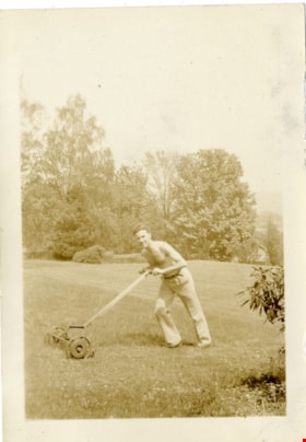
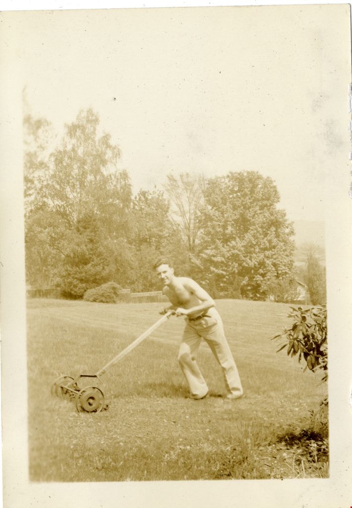
Crichton Hawkshaw
https://search.heritageburnaby.ca/link/museumdescription2669
- Repository
- Burnaby Village Museum
- Date
- 1937
- Collection/Fonds
- Hawkshaw family fonds
- Description Level
- Item
- Physical Description
- 1 photograph : sepia ; 5.5 x 8 cm
- Scope and Content
- Photograph of Crichton Hawkshaw pushing a lawn mower in the yard of house located at 3908 Deer Lake Avenue (6504 Deer Lake Avenue) in Burnaby where Crichton's mother Mabel Hawkshaw lived in 1937. Crichton is mowing the lawn with his shirt off. Tall trees and fence are visible behind.
- Repository
- Burnaby Village Museum
- Collection/Fonds
- Hawkshaw family fonds
- Description Level
- Item
- Physical Description
- 1 photograph : sepia ; 5.5 x 8 cm
- Scope and Content
- Photograph of Crichton Hawkshaw pushing a lawn mower in the yard of house located at 3908 Deer Lake Avenue (6504 Deer Lake Avenue) in Burnaby where Crichton's mother Mabel Hawkshaw lived in 1937. Crichton is mowing the lawn with his shirt off. Tall trees and fence are visible behind.
- Geographic Access
- Deer Lake Avenue
- Accession Code
- BV996.6.133
- Access Restriction
- No restrictions
- Reproduction Restriction
- No known restrictions
- Date
- 1937
- Media Type
- Photograph
- Historic Neighbourhood
- Burnaby Lake (Historic Neighbourhood)
- Planning Study Area
- Morley-Buckingham Area
- Scan Resolution
- 600
- Scan Date
- 2/9/2010
- Scale
- 100
- Notes
- Title based on contents of photograph
- Caption for photograph reads: "Mowing"
- Photograph is part of photograph album BV996.6.1
Images
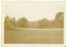
Crichton Hawkshaw
https://search.heritageburnaby.ca/link/museumdescription2671
- Repository
- Burnaby Village Museum
- Date
- 1937
- Collection/Fonds
- Hawkshaw family fonds
- Description Level
- Item
- Physical Description
- 1 photograph : sepia ; 5.5 x 8 cm
- Scope and Content
- Photograph of Crichton Hawkshaw jumping over a sports net.
- Repository
- Burnaby Village Museum
- Collection/Fonds
- Hawkshaw family fonds
- Description Level
- Item
- Physical Description
- 1 photograph : sepia ; 5.5 x 8 cm
- Scope and Content
- Photograph of Crichton Hawkshaw jumping over a sports net.
- Subjects
- Recreational Activities
- Geographic Access
- Deer Lake Avenue
- Accession Code
- BV996.6.135
- Access Restriction
- No restrictions
- Reproduction Restriction
- No known restrictions
- Date
- 1937
- Media Type
- Photograph
- Historic Neighbourhood
- Burnaby Lake (Historic Neighbourhood)
- Planning Study Area
- Morley-Buckingham Area
- Scan Resolution
- 600
- Scan Date
- 2/9/2010
- Scale
- 100
- Notes
- Title based on contents of photograph
- Caption for photograph reads: "Just"
- Photograph is part of photograph album BV996.6.1
Images


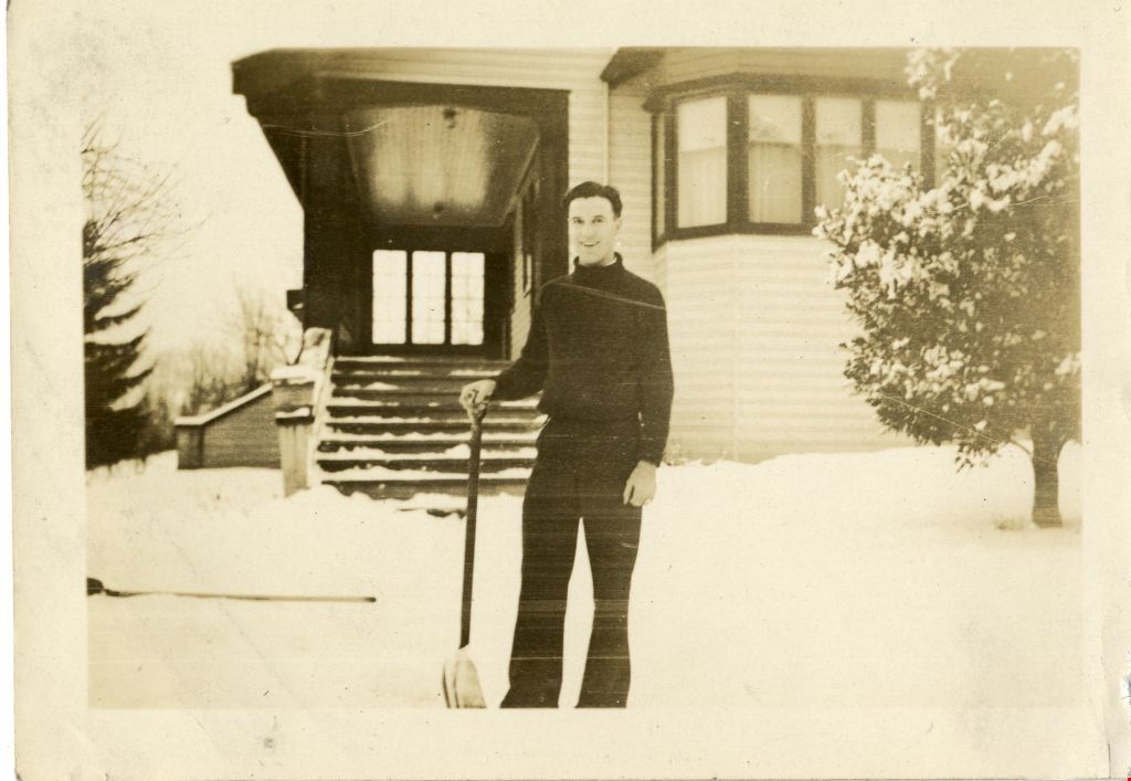
Crichton Hawkshaw
https://search.heritageburnaby.ca/link/museumdescription3536
- Repository
- Burnaby Village Museum
- Date
- January 13, 1937
- Collection/Fonds
- Hawkshaw family fonds
- Description Level
- Item
- Physical Description
- 1 photograph : sepia ; 5.5 x 8 cm
- Scope and Content
- Photograph of Crichton Hankshaw standing outside 3908 Deer Lake Avenue in the wintertime with his hand resting on a snow shovel.
- Repository
- Burnaby Village Museum
- Collection/Fonds
- Hawkshaw family fonds
- Description Level
- Item
- Physical Description
- 1 photograph : sepia ; 5.5 x 8 cm
- Scope and Content
- Photograph of Crichton Hankshaw standing outside 3908 Deer Lake Avenue in the wintertime with his hand resting on a snow shovel.
- Subjects
- Natural Phenomena - Snow
- Geographic Access
- Deer Lake Avenue
- Accession Code
- BV996.6.127
- Access Restriction
- No restrictions
- Reproduction Restriction
- No known restrictions
- Date
- January 13, 1937
- Media Type
- Photograph
- Historic Neighbourhood
- Burnaby Lake (Historic Neighbourhood)
- Planning Study Area
- Morley-Buckingham Area
- Scan Resolution
- 600
- Scan Date
- 2/9/2010
- Scale
- 100
- Notes
- Title based on contents of photograph
- Caption for photograph reads: "JAN 13/1937 / ME"
- Photograph is part of photograph album BV996.6.1
Images
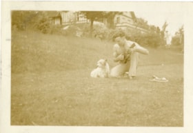
Crichton Hawkshaw and Betty
https://search.heritageburnaby.ca/link/museumdescription2667
- Repository
- Burnaby Village Museum
- Date
- 1937
- Collection/Fonds
- Hawkshaw family fonds
- Description Level
- Item
- Physical Description
- 1 photograph : sepia ; 5.5 x 8 cm
- Scope and Content
- Photograph of Crichton Hawkshaw sitting next to a terrier named Betty and serenading her with a ukulele.
- Repository
- Burnaby Village Museum
- Collection/Fonds
- Hawkshaw family fonds
- Description Level
- Item
- Physical Description
- 1 photograph : sepia ; 5.5 x 8 cm
- Scope and Content
- Photograph of Crichton Hawkshaw sitting next to a terrier named Betty and serenading her with a ukulele.
- Subjects
- Animals - Dogs
- Geographic Access
- Deer Lake Avenue
- Accession Code
- BV996.6.131
- Access Restriction
- No restrictions
- Reproduction Restriction
- No known restrictions
- Date
- 1937
- Media Type
- Photograph
- Historic Neighbourhood
- Burnaby Lake (Historic Neighbourhood)
- Planning Study Area
- Morley-Buckingham Area
- Scan Resolution
- 600
- Scan Date
- 2/9/2010
- Scale
- 100
- Notes
- Title based on contents of photograph
- Caption for photograph reads: "Serernading [sic] Betty"
- Photograph is part of photograph album BV996.6.1
Images

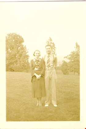
Crichton Hawkshaw and Dot
https://search.heritageburnaby.ca/link/museumdescription2705
- Repository
- Burnaby Village Museum
- Date
- 1937
- Collection/Fonds
- Hawkshaw family fonds
- Description Level
- Item
- Physical Description
- 1 photograph : sepia ; 5.5 x 8 cm
- Scope and Content
- Photograph of Crichton Hawkshaw and Dot standing on the lawn of the house located at 3908 Deer Lake Avenue (6504 Deer Lake Avenue) in Burnaby (R.F. Anderson house). Mabel Hawkshaw was livng in this house in 1937.
- Repository
- Burnaby Village Museum
- Collection/Fonds
- Hawkshaw family fonds
- Description Level
- Item
- Physical Description
- 1 photograph : sepia ; 5.5 x 8 cm
- Scope and Content
- Photograph of Crichton Hawkshaw and Dot standing on the lawn of the house located at 3908 Deer Lake Avenue (6504 Deer Lake Avenue) in Burnaby (R.F. Anderson house). Mabel Hawkshaw was livng in this house in 1937.
- Geographic Access
- Deer Lake Avenue
- Accession Code
- BV996.6.137
- Access Restriction
- No restrictions
- Reproduction Restriction
- No known restrictions
- Date
- 1937
- Media Type
- Photograph
- Historic Neighbourhood
- Burnaby Lake (Historic Neighbourhood)
- Planning Study Area
- Morley-Buckingham Area
- Scan Resolution
- 600
- Scan Date
- 2/18/2010
- Scale
- 100
- Notes
- Title based on contents of photograph
- Caption for photograph reads: "Dot + Me"
- Photograph is part of photograph album BV996.6.1
Images
