Narrow Results By

Burnaby Village Museum
https://search.heritageburnaby.ca/link/landmark808
- Repository
- Burnaby Heritage Planning
- Geographic Access
- Deer Lake Avenue
- Associated Dates
- 1971
- Heritage Value
- The Burnaby Village Museum is a ten-acre heritage site located adjacent to Deer Lake. The site was originally created as a B.C. Centennial Project in 1971. The official sod turning for was April 11, 1971 by the then Governor General of Canada Roland Mitchener. The Village was initially managed by the Century Park Museum Association, a volunteer society of Burnaby citizens. Over the years many heritage building which could not be maintained in their original locations have been moved to the museum. Today half of the buildings in the village are heritage structures and the remainder are reproductions. In 1990 the City of Burnaby assumed direct management of the Village, and the museum became part of the Parks, Recreation and Culture Department. Visitors can enjoy the shops on Hill Street, ride the Parker 119 Carousel, and climb aboard the Interurban 1223 tram.
- Historic Neighbourhood
- Burnaby Lake (Historic Neighbourhood)
- Planning Study Area
- Douglas-Gilpin Area
- Morley-Buckingham Area
- Street Address
- 6501 Deer Lake Avenue
- Street View URL
- Google Maps Street View
Images


H.T. Ceperley Estate 'Fairacres' Greenhouse Foundation Wall
https://search.heritageburnaby.ca/link/landmark862
- Repository
- Burnaby Heritage Planning
- Description
- The original rubble stone walls that formed the foundation for a greenhouses adjacent to the Steam Plant Building provided heat to several greenhouses on the estate propoerty. The Root House, which is to the north of the Greenhouse Foundation Wall, provided storage for the farm operation.
- Associated Dates
- 1908
- Formal Recognition
- Heritage Designation, Community Heritage Register
- Repository
- Burnaby Heritage Planning
- Geographic Access
- Deer Lake Avenue
- Associated Dates
- 1908
- Formal Recognition
- Heritage Designation, Community Heritage Register
- Enactment Type
- Bylaw No. 140665
- Enactment Date
- 23/11/1992
- Description
- The original rubble stone walls that formed the foundation for a greenhouses adjacent to the Steam Plant Building provided heat to several greenhouses on the estate propoerty. The Root House, which is to the north of the Greenhouse Foundation Wall, provided storage for the farm operation.
- Heritage Value
- The outbuildings at 'Fairacres' are a rare surviving architecturally-designed ensemble of agricultural structures that exist in complementary harmony with the main estate house. Architect Robert Mackay Fripp (1858-1917), an outspoken advocate of Arts and Crafts design, was retained by the Ceperleys to design several original outbuildings on their estate, which was designed as a country estate with a working farm that included over 10 acres of productive berry and vegetable fields, with a large kitchen garden, a root house to store food, an orchard, and greenhouses heated by steam. The agricultural potential of the Deer Lake area made it one of the first parts of the municipality to attract settlement. In 1909, the Ceperleys built three large greenhouses heated by an adjacent steam plant (Fairacres Steam Plant). The greenhouses featured granite foundation walls, including this one which remains intact. The Ceperleys employed a large staff to manage the estate's agricultural production, including Chinese farm labourers. Produce was grown for use at the estate, and for sale at local markets. Agricultural use of the estate continued when a Catholic order of Benedictine monks purchased the estate as part of the Priory of St. Joseph and the Seminary of Christ the King, and continued to farm the land until 1953.
- Defining Elements
- Key elements that define the heritage character of the ‘Fairacres’ Steam Plant Building include its: - overall spatial arrangement of the Greenhouse Foundation Wall in relation to the Steam Plant Building and the Root House - original rubble stone walls reflecting the Arts and Crafts design aesthetic of the estate buildings.
- Locality
- Deer Lake Park
- Historic Neighbourhood
- Burnaby Lake (Historic Neighbourhood)
- Planning Study Area
- Douglas-Gilpin Area
- Architect
- Robert Mackay Fripp
- Function
- Primary Historic--Outbuilding
- Community
- Burnaby
- Cadastral Identifier
- P.I.D. No. 004-493-311 Legal Description: Block 3 Except: Part subdivided by Plan 26865, District Lot 79, Group 1, New Westminster District, Plan 536
- Boundaries
- ‘Fairacres’ is comprised of a single municipally-owned property located at 6344 Deer Lake Avenue, Burnaby.
- Area
- 17,065.00
- Contributing Resource
- Landscape Feature
- Remains
- Ownership
- Public (local)
- Other Collection
- Burnaby Historical Society, Community Archives: Ceperley Photograph Album
- Documentation
- Heritage Site Files: PC77000 20. City of Burnaby Planning and Building Department, 4949 Canada Way, Burnaby, B.C., V5G 1M2
- Street Address
- 6344 Deer Lake Avenue
Images


H.T. Ceperley Estate 'Fairacres' Root House
https://search.heritageburnaby.ca/link/landmark527
- Repository
- Burnaby Heritage Planning
- Description
- The ‘Fairacres’ Root House is a long, low one-storey masonry building, measuring 4.6 metres by 9.1 metres, with massively buttressed concrete walls and foundations. Built into sloping ground adjacent to the location of the former greenhouses, the surviving orchard and the kitchen entrance of the ma…
- Associated Dates
- 1908
- Formal Recognition
- Heritage Designation, Community Heritage Register
- Repository
- Burnaby Heritage Planning
- Geographic Access
- Deer Lake Avenue
- Associated Dates
- 1908
- Formal Recognition
- Heritage Designation, Community Heritage Register
- Enactment Type
- Bylaw No. 9807
- Enactment Date
- 23/11/1992
- Description
- The ‘Fairacres’ Root House is a long, low one-storey masonry building, measuring 4.6 metres by 9.1 metres, with massively buttressed concrete walls and foundations. Built into sloping ground adjacent to the location of the former greenhouses, the surviving orchard and the kitchen entrance of the main house, 'Fairacres,' this functional structure was used as a frost-free store for fruit and vegetables for the family's use.
- Heritage Value
- The outbuildings at 'Fairacres' are a rare surviving architecturally-designed ensemble of agricultural structures that exist in complementary harmony with the main estate house. Architect Robert Mackay Fripp (1858-1917), an outspoken advocate of Arts and Crafts design, was retained by the Ceperleys to design several original outbuildings on their estate. The Root House is important as a rare surviving, and exceptionally large, example of this building type in the Vancouver region. Unusual in the fact that an architect designed a building of such modest aspirations, it is also remarkable in its method of construction. The use of concrete as a structural material is one of the earliest in the region and extraordinary for its use on such a modest vernacular outbuilding; root cellars were typically built of loose stone. Built in 1908, the Root House was significantly altered in the 1960s and restored to its original design in 2000. The building is significant as an indicator of the market gardening activity in the area around Deer Lake and of the country-house self-sufficiency practiced by the Ceperley family. The Root House illustrates the cultural, aesthetic, and lifestyle values of the Ceperleys in constructing such a large building for storing their own produce.
- Defining Elements
- The outbuildings at 'Fairacres' are a rare surviving architecturally-designed ensemble of agricultural structures that exist in complementary harmony with the main estate house. Architect Robert Mackay Fripp (1858-1917), an outspoken advocate of Arts and Crafts design, was retained by the Ceperleys to design several original outbuildings on their estate. The Root House is important as a rare surviving, and exceptionally large, example of this building type in the Vancouver region. Unusual in the fact that an architect designed a building of such modest aspirations, it is also remarkable in its method of construction. The use of concrete as a structural material is one of the earliest in the region and extraordinary for its use on such a modest vernacular outbuilding; root cellars were typically built of loose stone. Built in 1908, the Root House was significantly altered in the 1960s and restored to its original design in 2000. The building is significant as an indicator of the market gardening activity in the area around Deer Lake and of the country-house self-sufficiency practiced by the Ceperley family. The Root House illustrates the cultural, aesthetic, and lifestyle values of the Ceperleys in constructing such a large building for storing their own produce.
- Locality
- Deer Lake Park
- Historic Neighbourhood
- Burnaby Lake (Historic Neighbourhood)
- Planning Study Area
- Douglas-Gilpin Area
- Architect
- Robert Mackay Fripp
- Function
- Primary Historic--Outbuilding
- Secondary Historic--Food Storage
- Community
- Burnaby
- Cadastral Identifier
- P.I.D. No. 004-493-311 Legal Description: Block 3 Except: Part subdivided by Plan 26865, District Lot 79, Group 1, New Westminster District, Plan 536
- Boundaries
- ‘Fairacres’ is comprised of a single municipally-owned property located at 6344 Deer Lake Avenue, Burnaby.
- Area
- 17,065.00
- Contributing Resource
- Building
- Landscape Feature
- Ownership
- Public (local)
- Other Collection
- Burnaby Historical Society, Community Archives: Ceperley Photograph Album
- Documentation
- Heritage Site Files: PC77000 20. City of Burnaby Planning and Building Department, 4949 Canada Way, Burnaby, B.C., V5G 1M2
- Street Address
- 6344 Deer Lake Avenue
Images


H.T. Ceperley Estate 'Fairacres' Steam Plant Building
https://search.heritageburnaby.ca/link/landmark528
- Repository
- Burnaby Heritage Planning
- Description
- Designed in the British Arts and Crafts style, the ‘Fairacres’ Steam Plant Buiding is a single-storey wood frame building with a gabled roof that originally housed the apparatus for climate control in the greenhouses, formerly located to its north. The original rubble stone walls that formed the fo…
- Associated Dates
- 1908
- Formal Recognition
- Heritage Designation, Community Heritage Register
- Repository
- Burnaby Heritage Planning
- Geographic Access
- Deer Lake Avenue
- Associated Dates
- 1908
- Formal Recognition
- Heritage Designation, Community Heritage Register
- Enactment Type
- Bylaw No. 9807
- Enactment Date
- 23/11/1992
- Description
- Designed in the British Arts and Crafts style, the ‘Fairacres’ Steam Plant Buiding is a single-storey wood frame building with a gabled roof that originally housed the apparatus for climate control in the greenhouses, formerly located to its north. The original rubble stone walls that formed the foundation for the greenhouses stand adjacent. The Steam Plant Building stands as a pendant to the Root House, which is to the north of the former greenhouses.
- Heritage Value
- The outbuildings at 'Fairacres' are a rare surviving architecturally-designed ensemble of agricultural structures that exist in complementary harmony with the main estate house. Architect Robert Mackay Fripp (1858-1917), an outspoken advocate of Arts and Crafts design, was retained by the Ceperleys to design several original outbuildings on their estate. The Ceperleys operated 'Fairacres' with staff, a farm manager and workers, including Chinese, to grow produce for themselves and for sale at local markets. The Steam Plant Building illustrates the market gardening activity of the area around Deer Lake and its importance to the Ceperley family, which valued a year-round supply of fresh fruit and vegetables for the kitchen and flowers for the house. It also illustrates the cultural and aesthetic values of the Ceperleys in retaining an architect to design a functional outbuilding using an accepted and contemporary architectural style. Built in 1908, the Steam Plant Building was significantly altered in the 1960s and restored to its original design in 2000.
- Defining Elements
- Key elements that define the heritage character of the ‘Fairacres’ Steam Plant Building include its: - overall spatial arrangement of the Steam Plant Building in relation to the former greenhouses and the Root House - side gable roof with cedar shingle cladding. - tall brick chimney indicitive of the building's original function. - distinctive Arts and Crafts architectural features such as the shingle wall cladding with decorative shingling under window sills, deep eaves, and pebble-dashed concrete foundation walls - six-paned wooden-sash casement windows - simple functional interior features - rubble stone walls that formed the foundation for the greenhouses
- Locality
- Deer Lake Park
- Historic Neighbourhood
- Burnaby Lake (Historic Neighbourhood)
- Planning Study Area
- Douglas-Gilpin Area
- Architect
- Robert Mackay Fripp
- Function
- Primary Historic--Outbuilding
- Community
- Burnaby
- Cadastral Identifier
- P.I.D. No. 004-493-311 Legal Description: Block 3 Except: Part subdivided by Plan 26865, District Lot 79, Group 1, New Westminster District, Plan 536
- Boundaries
- ‘Fairacres’ is comprised of a single municipally-owned property located at 6344 Deer Lake Avenue, Burnaby.
- Area
- 17,065.00
- Contributing Resource
- Building
- Landscape Feature
- Ownership
- Public (local)
- Other Collection
- Burnaby Historical Society, Community Archives: Ceperley Photograph Album
- Documentation
- Heritage Site Files: PC77000 20. City of Burnaby Planning and Building Department, 4949 Canada Way, Burnaby, B.C., V5G 1M2
- Street Address
- 6344 Deer Lake Avenue
Images

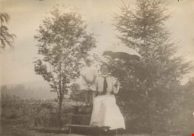
Annie and Kitty at Brookfield
https://search.heritageburnaby.ca/link/archivedescription39557
- Repository
- City of Burnaby Archives
- Date
- 1902
- Collection/Fonds
- Peers Family and Hill Family fonds
- Description Level
- Item
- Physical Description
- 1 photograph : b&w ; 7.5 x 10.5 cm on page 21.5 x 28 cm (pasted in album)
- Scope and Content
- Photograph of Annie Hill and her daughter Kitty on a picnic table in front of two trees. Annie is holding an umbrella. This photograph was probably taken at the Hill family home known as Brookfield, which was located on Deer Lake Avenue. A road (possibly Douglas Road) is partially visible in the b…
- Repository
- City of Burnaby Archives
- Date
- 1902
- Collection/Fonds
- Peers Family and Hill Family fonds
- Physical Description
- 1 photograph : b&w ; 7.5 x 10.5 cm on page 21.5 x 28 cm (pasted in album)
- Description Level
- Item
- Record No.
- 477-876
- Access Restriction
- No restrictions
- Reproduction Restriction
- No known restrictions
- Accession Number
- 2007-12
- Scope and Content
- Photograph of Annie Hill and her daughter Kitty on a picnic table in front of two trees. Annie is holding an umbrella. This photograph was probably taken at the Hill family home known as Brookfield, which was located on Deer Lake Avenue. A road (possibly Douglas Road) is partially visible in the background.
- Media Type
- Photograph
- Notes
- Title based on contents of photograph
- Geographic Access
- Deer Lake Avenue
- Street Address
- 6501 Deer Lake Avenue
- Historic Neighbourhood
- Burnaby Lake (Historic Neighbourhood)
- Planning Study Area
- Morley-Buckingham Area
Images


Art Gallery
https://search.heritageburnaby.ca/link/archivedescription93607
- Repository
- City of Burnaby Archives
- Date
- October 16, 1977
- Collection/Fonds
- Burnaby Public Library Contemporary Visual Archive Project
- Description Level
- Item
- Physical Description
- 1 photograph : b&w ; 12.5 x 17.5 cm
- Scope and Content
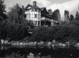
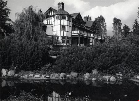
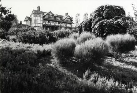
- Photograph of the front exterior of the Burnaby Art Gallery (Ceperley/Fairacres) and Century Gardens. The photograph is taken from a garden path, facing northwest.
- Repository
- City of Burnaby Archives
- Date
- October 16, 1977
- Collection/Fonds
- Burnaby Public Library Contemporary Visual Archive Project
- Physical Description
- 1 photograph : b&w ; 12.5 x 17.5 cm
- Description Level
- Item
- Record No.
- 556-564
- Access Restriction
- No restrictions
- Reproduction Restriction
- Reproduce for fair dealing purposes only
- Accession Number
- 2017-57
- Scope and Content
- Photograph of the front exterior of the Burnaby Art Gallery (Ceperley/Fairacres) and Century Gardens. The photograph is taken from a garden path, facing northwest.
- Names
- Burnaby Art Gallery
- Media Type
- Photograph
- Photographer
- Chapman, Fred
- Notes
- Title taken from project information form
- Accompanied by a project information form and 1 photograph (b&w negative ; 9.5 x 12.5 cm)
- BPL no. 8
- Geographic Access
- Deer Lake Avenue
- Street Address
- 6344 Deer Lake Avenue
- Historic Neighbourhood
- Burnaby Lake (Historic Neighbourhood)
- Planning Study Area
- Douglas-Gilpin Area
Images


Art Gallery
https://search.heritageburnaby.ca/link/archivedescription93608
- Repository
- City of Burnaby Archives
- Date
- October 16, 1977
- Collection/Fonds
- Burnaby Public Library Contemporary Visual Archive Project
- Description Level
- Item
- Physical Description
- 1 photograph : b&w ; 12.5 x 17.5 cm
- Scope and Content
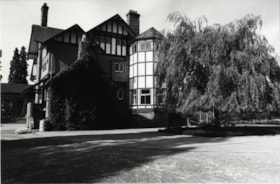
- Photograph of the rear exterior of the Burnaby Art Gallery (Ceperley/Fairacres). The photograph is taken from a parking lot, facing east, and shows the entrance to the Art Gallery.
- Repository
- City of Burnaby Archives
- Date
- October 16, 1977
- Collection/Fonds
- Burnaby Public Library Contemporary Visual Archive Project
- Physical Description
- 1 photograph : b&w ; 12.5 x 17.5 cm
- Description Level
- Item
- Record No.
- 556-565
- Access Restriction
- No restrictions
- Reproduction Restriction
- Reproduce for fair dealing purposes only
- Accession Number
- 2017-57
- Scope and Content
- Photograph of the rear exterior of the Burnaby Art Gallery (Ceperley/Fairacres). The photograph is taken from a parking lot, facing east, and shows the entrance to the Art Gallery.
- Names
- Burnaby Art Gallery
- Media Type
- Photograph
- Photographer
- Chapman, Fred
- Notes
- Title taken from project information form
- Accompanied by a project information form and 1 photograph (b&w negative ; 9.5 x 12.5 cm)
- BPL no. 9
- Geographic Access
- Deer Lake Avenue
- Street Address
- 6344 Deer Lake Avenue
- Historic Neighbourhood
- Burnaby Lake (Historic Neighbourhood)
- Planning Study Area
- Douglas-Gilpin Area
Images

![Avalon, [1906] (date of original), copied 1986 thumbnail](/media/hpo/_Data/_Archives_Images/_Unrestricted/204/204-785.jpg?width=280)
Avalon
https://search.heritageburnaby.ca/link/archivedescription35925
- Repository
- City of Burnaby Archives
- Date
- [1906] (date of original), copied 1986
- Collection/Fonds
- Burnaby Historical Society fonds
- Description Level
- Item
- Physical Description
- 1 photograph : b&w ; 12.7 x 17.8 cm print
- Scope and Content
- Photograph of three people and a dog standing in front of the Hart family cottage on Deer Lake.
- Repository
- City of Burnaby Archives
- Date
- [1906] (date of original), copied 1986
- Collection/Fonds
- Burnaby Historical Society fonds
- Subseries
- Pioneer Tales subseries
- Physical Description
- 1 photograph : b&w ; 12.7 x 17.8 cm print
- Description Level
- Item
- Record No.
- 204-785
- Access Restriction
- No restrictions
- Reproduction Restriction
- No known restrictions
- Accession Number
- BHS1988-03
- Scope and Content
- Photograph of three people and a dog standing in front of the Hart family cottage on Deer Lake.
- Media Type
- Photograph
- Notes
- Title based on contents of photograph
- Geographic Access
- Deer Lake
- Deer Lake Avenue
- Street Address
- 6664 Deer Lake Avenue
- Historic Neighbourhood
- Burnaby Lake (Historic Neighbourhood)
- Planning Study Area
- Morley-Buckingham Area
Images
![Avalon, [1906] (date of original), copied 1986 thumbnail](/media/hpo/_Data/_Archives_Images/_Unrestricted/204/204-785.jpg)

Bird's Eye View of the Burnaby Lake Area
https://search.heritageburnaby.ca/link/museumdescription15144
- Repository
- Burnaby Village Museum
- Date
- 1977
- Collection/Fonds
- Century Park Museum Association fonds
- Description Level
- Item
- Physical Description
- 1 map : b&w print on paper ; 43 x 63.5 cm
- Scope and Content
- Item consists of a map titled "Birds Eye View of the Burnaby Lake Area Circa 1910". The overview of the Burnaby Lake area was compiled and drawn at Heritage Village by curator John Adams and artist, Carol Swan. The map identifies the Burnaby Lake inter-urban tram line; roads including: Sperling Ave…
- Repository
- Burnaby Village Museum
- Collection/Fonds
- Century Park Museum Association fonds
- Description Level
- Item
- Physical Description
- 1 map : b&w print on paper ; 43 x 63.5 cm
- Material Details
- Scale indeterminable
- Scope and Content
- Item consists of a map titled "Birds Eye View of the Burnaby Lake Area Circa 1910". The overview of the Burnaby Lake area was compiled and drawn at Heritage Village by curator John Adams and artist, Carol Swan. The map identifies the Burnaby Lake inter-urban tram line; roads including: Sperling Avenue (Pole Line Road); Gilpin Avenue; Douglas Road; trail to Vancouver Westminster Road (Kingsway); Buckingham Avenue; Haszard Street; various farms and residences including: Charles Sprott "Norland"; H.T. Ceperley "Fairacres"; Claude Hill's "Brookfield farm" and "Broadview"; F.J. Hart's "Avalon"; Miss Woodward's former and new home, school and post office; Councillor Edgar's hunting cabin; Edgar Sprott's "Mayfield farm" and "Mayfield Lodge"; F.J. Peers "Greyfriars"; Arthur de Windt Haszard; Bernard Hill's boathouse as well as other landmarks including: Doran's Mill; tram stations; Burnaby Lake Store; logging camps; wood cutter's shacks; ice houses; cranberry bog; Still Creek; Deer Lake; Burnaby Lake; Deer Lake Creek; Provincial Government Reserve Proposed Hospital (later Oakalla Prison).
- Creator
- Adams, John
- Swan, Carol
- Names
- Hill, Arthur Claude
- Sprott, Charles Frederick
- Sprott, Louis "Edgar"
- Hart, Frederick John, 1884-1945
- Ceperley, H.T.
- Woodward, Maude
- Woodward, Harriet
- Peers, Francis J.
- Haszard, Arthur de Windt
- Hill, Bernard R.
- Geographic Access
- Deer Lake Avenue
- Sperling Avenue
- Haszard Street
- Buckingham Avenue
- Accession Code
- BV021.1.3
- Access Restriction
- No restrictions
- Reproduction Restriction
- No known restrictions
- Date
- 1977
- Media Type
- Cartographic Material
- Historic Neighbourhood
- Burnaby Lake (Historic Neighbourhood)
- Planning Study Area
- Burnaby Lake Area
- Related Material
- See also: Life with the Moores of Hart House : pioneer days on Burnaby's Deer Lake
- Scan Resolution
- 600
- Scan Date
- 2021-11-12
- Scale
- 100
- Notes
- Transcribed title
- Compiled by John Adams; illustration by Carol Swan
- The map depicts the Burnaby Lake Tram Line as being double tracked, whereas in reality it was single tracked.
- Map is part of the book "Life with the Moores of Hart House : pioneer days on Burnaby's Deer Lake https://search.heritageburnaby.ca/permalink/museumlibrary6314-102
Images


Bird's Eye View of the Burnaby Lake Area
https://search.heritageburnaby.ca/link/museumdescription17543
- Repository
- Burnaby Village Museum
- Date
- 1977
- Collection/Fonds
- Century Park Museum Association fonds
- Description Level
- Item
- Physical Description
- 1 map : b&w print with watercolour ; 43 x 63.5 cm
- Scope and Content
- Item consists of a map titled "Birds Eye View of the Burnaby Lake Area Circa 1910". The overview of the Burnaby Lake area was compiled and drawn at Heritage Village by curator John Adams and artist, Carol Swan. The map identifies the Burnaby Lake inter-urban tram line; roads including: Sperling Ave…
- Repository
- Burnaby Village Museum
- Collection/Fonds
- Century Park Museum Association fonds
- Description Level
- Item
- Physical Description
- 1 map : b&w print with watercolour ; 43 x 63.5 cm
- Material Details
- Scale indeterminable
- Scope and Content
- Item consists of a map titled "Birds Eye View of the Burnaby Lake Area Circa 1910". The overview of the Burnaby Lake area was compiled and drawn at Heritage Village by curator John Adams and artist, Carol Swan. The map identifies the Burnaby Lake inter-urban tram line; roads including: Sperling Avenue (Pole Line Road); Gilpin Avenue; Douglas Road; trail to Vancouver Westminster Road (Kingsway); Buckingham Avenue; Haszard Street; various farms and residences including: Charles Sprott "Norland"; H.T. Ceperley "Fairacres"; Claude Hill's "Brookfield farm" and "Broadview"; F.J. Hart's "Avalon"; Miss Woodward's former and new home, school and post office; Councillor Edgar's hunting cabin; Edgar Sprott's "Mayfield farm" and "Mayfield Lodge"; F.J. Peers "Greyfriars"; Arthur de Windt Haszard; Bernard Hill's boathouse as well as other landmarks including: Doran's Mill; tram stations; Burnaby Lake Store; logging camps; wood cutter's shacks; ice houses; cranberry bog; Still Creek; Deer Lake; Burnaby Lake; Deer Lake Creek; Provincial Government Reserve Proposed Hospital (later Oakalla Prison).
- Creator
- Adams, John
- Swan, Carol
- Names
- Hill, Arthur Claude
- Sprott, Charles Frederick
- Sprott, Louis "Edgar"
- Hart, Frederick John, 1884-1945
- Ceperley, H.T.
- Woodward, Maude
- Woodward, Harriet
- Peers, Francis J.
- Haszard, Arthur de Windt
- Hill, Bernard R.
- Geographic Access
- Deer Lake Avenue
- Sperling Avenue
- Haszard Street
- Buckingham Avenue
- Accession Code
- BV021.1.4
- Access Restriction
- No restrictions
- Reproduction Restriction
- No known restrictions
- Date
- 1977
- Media Type
- Cartographic Material
- Historic Neighbourhood
- Burnaby Lake (Historic Neighbourhood)
- Planning Study Area
- Burnaby Lake Area
- Related Material
- See also: Life with the Moores of Hart House : pioneer days on Burnaby's Deer Lake
- Scan Resolution
- 600
- Scan Date
- 2021-11-12
- Scale
- 100
- Notes
- Transcribed title
- Compiled by John Adams; illustration by Carol Swan
- The map depicts the Burnaby Lake Tram Line as being double tracked, whereas in reality it was single tracked.
- Map is part of the book "Life with the Moores of Hart House : pioneer days on Burnaby's Deer Lake https://search.heritageburnaby.ca/permalink/museumlibrary6314-102
- This is a print made from original illustration and appears to be hand-coloured with watercolour at a later date.
Images

![Brookfield, [1900] thumbnail](/media/hpo/_Data/_BVM_Images/1976/1976_0139_0005_001.jpg?width=280)
Brookfield
https://search.heritageburnaby.ca/link/museumdescription754
- Repository
- Burnaby Village Museum
- Date
- [1900]
- Collection/Fonds
- Burnaby Village Museum Photograph collection
- Description Level
- Item
- Physical Description
- 1 photograph : b&w ; 9.9 x 14.0 cm mounted on cardboard 17.8 x 23.0 cm
- Scope and Content
- Photograph of "Brookfield", the first home of Mr. and Mrs. Louis Claude Hill. The Hills, including the daughter Kitty Hill, are on the lawn on the lower right corner. The man sitting on the steps is identified by the inscription on the photograph card mount as Mr. Wetenhall. Annotations on the back…
- Repository
- Burnaby Village Museum
- Collection/Fonds
- Burnaby Village Museum Photograph collection
- Description Level
- Item
- Physical Description
- 1 photograph : b&w ; 9.9 x 14.0 cm mounted on cardboard 17.8 x 23.0 cm
- Scope and Content
- Photograph of "Brookfield", the first home of Mr. and Mrs. Louis Claude Hill. The Hills, including the daughter Kitty Hill, are on the lawn on the lower right corner. The man sitting on the steps is identified by the inscription on the photograph card mount as Mr. Wetenhall. Annotations on the back of the card read: "'Brookfield' / Burnaby Lake" and "L.C. Hill & Kitty M. Hill, Mr. Wetenhall." Another annotation reads: "App. 1900."
- Subjects
- Buildings - Residential - Houses
- Geographic Access
- Deer Lake Avenue
- Street Address
- 6501 Deer Lake Avenue
- Accession Code
- HV976.139.5
- Access Restriction
- No restrictions
- Reproduction Restriction
- No known restrictions
- Date
- [1900]
- Media Type
- Photograph
- Historic Neighbourhood
- Burnaby Lake (Historic Neighbourhood)
- Planning Study Area
- Morley-Buckingham Area
- Related Material
- For another view of Brookfield home, see HV976.139.53
- Scan Resolution
- 600
- Scan Date
- 2023-06-27
- Notes
- Title based on contents of photograph
Images
![Brookfield, [1900] thumbnail](/media/hpo/_Data/_BVM_Images/1976/1976_0139_0005_001.jpg)

![Brookfield in the Snow, [1904] thumbnail](/media/hpo/_Data/_Archives_Images/_Unrestricted/477/477-865.jpg?width=280)
Brookfield in the Snow
https://search.heritageburnaby.ca/link/archivedescription39546
- Repository
- City of Burnaby Archives
- Date
- [1904]
- Collection/Fonds
- Peers Family and Hill Family fonds
- Description Level
- Item
- Physical Description
- 1 photograph : b&w ; 5 x 5.5 cm on page 21.5 x 28 cm (pasted in album)
- Scope and Content
- Photograph of the home of Claude Hill, known as Brookfield in the Burnaby Lake area. The house and surrounding yard are covered with snow.
- Repository
- City of Burnaby Archives
- Date
- [1904]
- Collection/Fonds
- Peers Family and Hill Family fonds
- Physical Description
- 1 photograph : b&w ; 5 x 5.5 cm on page 21.5 x 28 cm (pasted in album)
- Description Level
- Item
- Record No.
- 477-865
- Access Restriction
- No restrictions
- Reproduction Restriction
- No known restrictions
- Accession Number
- 2007-12
- Scope and Content
- Photograph of the home of Claude Hill, known as Brookfield in the Burnaby Lake area. The house and surrounding yard are covered with snow.
- Media Type
- Photograph
- Notes
- Title based on contents of photograph
- Geographic Access
- Deer Lake Avenue
- Street Address
- 6501 Deer Lake Avenue
- Historic Neighbourhood
- Burnaby Lake (Historic Neighbourhood)
- Planning Study Area
- Morley-Buckingham Area
Images
![Brookfield in the Snow, [1904] thumbnail](/media/hpo/_Data/_Archives_Images/_Unrestricted/477/477-865.jpg)
![Brookfield in the winter, [1904] thumbnail](/media/hpo/_Data/_Archives_Images/_Unrestricted/477/477-149.jpg?width=280)
Brookfield in the winter
https://search.heritageburnaby.ca/link/archivedescription38830
- Repository
- City of Burnaby Archives
- Date
- [1904]
- Collection/Fonds
- Peers Family and Hill Family fonds
- Description Level
- Item
- Physical Description
- 1 photograph : b&w ; 5 x 5.5 cm on page 11.5 x 14 cm (pasted in album)
- Scope and Content
- Photograph of Brookfield, the home of Claude and Annie Hill in the Burnaby Lake area, covered with snow. The property is the current site of the Burnaby Village Museum.
- Repository
- City of Burnaby Archives
- Date
- [1904]
- Collection/Fonds
- Peers Family and Hill Family fonds
- Physical Description
- 1 photograph : b&w ; 5 x 5.5 cm on page 11.5 x 14 cm (pasted in album)
- Description Level
- Item
- Record No.
- 477-149
- Access Restriction
- No restrictions
- Reproduction Restriction
- No known restrictions
- Accession Number
- 2007-12
- Scope and Content
- Photograph of Brookfield, the home of Claude and Annie Hill in the Burnaby Lake area, covered with snow. The property is the current site of the Burnaby Village Museum.
- Media Type
- Photograph
- Notes
- Title based on contents of photograph
- Geographic Access
- Deer Lake Avenue
- Street Address
- 6501 Deer Lake Avenue
- Historic Neighbourhood
- Burnaby Lake (Historic Neighbourhood)
- Planning Study Area
- Morley-Buckingham Area
Images
![Brookfield in the winter, [1904] thumbnail](/media/hpo/_Data/_Archives_Images/_Unrestricted/477/477-149.jpg)
Burnaby Art Gallery
https://search.heritageburnaby.ca/link/archivedescription79804
- Repository
- City of Burnaby Archives
- Date
- October, 1976
- Collection/Fonds
- Burnaby Public Library Contemporary Visual Archive Project
- Description Level
- Item
- Physical Description
- 1 photograph : b&w ; 11 x 16 cm mounted on cardboard
- Scope and Content
- Photograph shows the Burnaby Art Gallery at 6344 Gilpin Street (later 6344 Deer Lake Avenue). Built in 1908 by R. P. Twizell as the private residence of Henry Ceperley. For a time, it was the home of Vancouver's former Mayor Buscombe. In 1940 it was occupied by the Order of Benedictine and later…
- Repository
- City of Burnaby Archives
- Date
- October, 1976
- Collection/Fonds
- Burnaby Public Library Contemporary Visual Archive Project
- Physical Description
- 1 photograph : b&w ; 11 x 16 cm mounted on cardboard
- Description Level
- Item
- Record No.
- 556-441
- Access Restriction
- No restrictions
- Reproduction Restriction
- Reproduce for fair dealing purposes only
- Accession Number
- 2013-13
- Scope and Content
- Photograph shows the Burnaby Art Gallery at 6344 Gilpin Street (later 6344 Deer Lake Avenue). Built in 1908 by R. P. Twizell as the private residence of Henry Ceperley. For a time, it was the home of Vancouver's former Mayor Buscombe. In 1940 it was occupied by the Order of Benedictine and later became the communal dwelling of the Canadian Temple of the Universal Foundation of More Abundant Life. The conversion of the estate to a cultural centre was Burnaby's centennial project and the first art show was held in June 1967.
- Subjects
- Buildings - Civic - Art Galleries
- Names
- Burnaby Art Gallery
- Media Type
- Photograph
- Photographer
- Salmon, Stu
- Notes
- Scope note taken directly from BPL photograph description.
- 1 b&w copy negative : 10 x 12.5 cm accompanying
- Geographic Access
- Deer Lake Avenue
- Gilpin Street
- Street Address
- 6344 Deer Lake Avenue
- 6344 Gilpin Street
- Historic Neighbourhood
- Burnaby Lake (Historic Neighbourhood)
- Planning Study Area
- Douglas-Gilpin Area
Images
Burnaby Art Gallery
https://search.heritageburnaby.ca/link/archivedescription79820
- Repository
- City of Burnaby Archives
- Date
- October, 1976
- Collection/Fonds
- Burnaby Public Library Contemporary Visual Archive Project
- Description Level
- Item
- Physical Description
- 1 photograph : b&w ; 11 x 16 cm mounted on cardboard
- Scope and Content
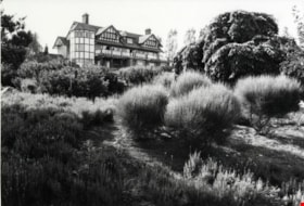
- Photograph shows a view of the Burnaby Art Gallery from the south side with a portion of Century Park Gardens in the foreground.
- Repository
- City of Burnaby Archives
- Date
- October, 1976
- Collection/Fonds
- Burnaby Public Library Contemporary Visual Archive Project
- Physical Description
- 1 photograph : b&w ; 11 x 16 cm mounted on cardboard
- Description Level
- Item
- Record No.
- 556-442
- Access Restriction
- No restrictions
- Reproduction Restriction
- Reproduce for fair dealing purposes only
- Accession Number
- 2013-13
- Scope and Content
- Photograph shows a view of the Burnaby Art Gallery from the south side with a portion of Century Park Gardens in the foreground.
- Subjects
- Buildings - Civic - Art Galleries
- Names
- Burnaby Art Gallery
- Media Type
- Photograph
- Photographer
- Salmon, Stu
- Notes
- Scope note taken directly from BPL photograph description.
- 1 b&w copy negative : 10 x 12.5 cm accompanying
- Geographic Access
- Deer Lake Avenue
- Gilpin Street
- Street Address
- 6344 Deer Lake Avenue
- 6344 Gilpin Street
- Historic Neighbourhood
- Burnaby Lake (Historic Neighbourhood)
- Planning Study Area
- Douglas-Gilpin Area
Images
Burnaby Art Gallery
https://search.heritageburnaby.ca/link/archivedescription79822
- Repository
- City of Burnaby Archives
- Date
- July, 1976
- Collection/Fonds
- Burnaby Public Library Contemporary Visual Archive Project
- Description Level
- Item
- Physical Description
- 1 photograph : b&w ; 11 x 16 cm mounted on cardboard
- Scope and Content
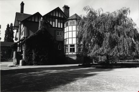
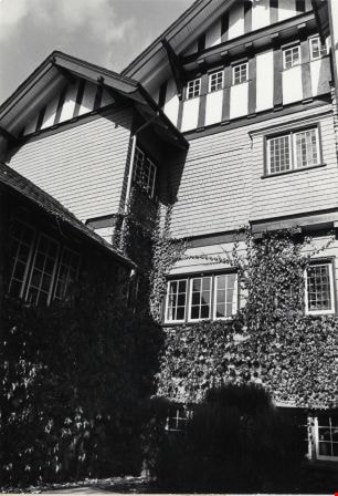
- Photograph shows a view of the Burnaby Art Gallery.
- Repository
- City of Burnaby Archives
- Date
- July, 1976
- Collection/Fonds
- Burnaby Public Library Contemporary Visual Archive Project
- Physical Description
- 1 photograph : b&w ; 11 x 16 cm mounted on cardboard
- Description Level
- Item
- Record No.
- 556-443
- Access Restriction
- No restrictions
- Reproduction Restriction
- Reproduce for fair dealing purposes only
- Accession Number
- 2013-13
- Scope and Content
- Photograph shows a view of the Burnaby Art Gallery.
- Subjects
- Buildings - Civic - Art Galleries
- Names
- Burnaby Art Gallery
- Media Type
- Photograph
- Photographer
- Gardiner, Robert
- Notes
- Scope note taken directly from BPL photograph description.
- 1 b&w copy negative : 10 x 12.5 cm accompanying
- Geographic Access
- Deer Lake Avenue
- Gilpin Street
- Street Address
- 6344 Deer Lake Avenue
- 6344 Gilpin Street
- Historic Neighbourhood
- Burnaby Lake (Historic Neighbourhood)
- Planning Study Area
- Douglas-Gilpin Area
Images
Burnaby Art Gallery
https://search.heritageburnaby.ca/link/archivedescription79823
- Repository
- City of Burnaby Archives
- Date
- October, 1976
- Collection/Fonds
- Burnaby Public Library Contemporary Visual Archive Project
- Description Level
- Item
- Physical Description
- 1 photograph : b&w ; 11 x 16 cm mounted on cardboard
- Scope and Content
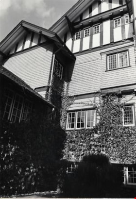
- Photograph shows the west wall of the Burnaby Art Gallery.
- Repository
- City of Burnaby Archives
- Date
- October, 1976
- Collection/Fonds
- Burnaby Public Library Contemporary Visual Archive Project
- Physical Description
- 1 photograph : b&w ; 11 x 16 cm mounted on cardboard
- Description Level
- Item
- Record No.
- 556-444
- Access Restriction
- No restrictions
- Reproduction Restriction
- Reproduce for fair dealing purposes only
- Accession Number
- 2013-13
- Scope and Content
- Photograph shows the west wall of the Burnaby Art Gallery.
- Subjects
- Buildings - Civic - Art Galleries
- Names
- Burnaby Art Gallery
- Media Type
- Photograph
- Photographer
- Salmon, Stu
- Notes
- Scope note taken directly from BPL photograph description.
- 1 b&w copy negative : 10 x 12.5 cm accompanying
- Geographic Access
- Deer Lake Avenue
- Gilpin Street
- Street Address
- 6344 Deer Lake Avenue
- 6344 Gilpin Street
- Historic Neighbourhood
- Burnaby Lake (Historic Neighbourhood)
- Planning Study Area
- Douglas-Gilpin Area
Images
Burnaby Art Gallery
https://search.heritageburnaby.ca/link/archivedescription79824
- Repository
- City of Burnaby Archives
- Date
- October, 1976
- Collection/Fonds
- Burnaby Public Library Contemporary Visual Archive Project
- Description Level
- Item
- Physical Description
- 1 photograph : b&w ; 11 x 16 cm mounted on cardboard
- Scope and Content
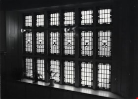
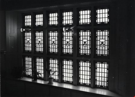
- Photograph shows a window inside the Burnaby Art Gallery.
- Repository
- City of Burnaby Archives
- Date
- October, 1976
- Collection/Fonds
- Burnaby Public Library Contemporary Visual Archive Project
- Physical Description
- 1 photograph : b&w ; 11 x 16 cm mounted on cardboard
- Description Level
- Item
- Record No.
- 556-445
- Access Restriction
- No restrictions
- Reproduction Restriction
- Reproduce for fair dealing purposes only
- Accession Number
- 2013-13
- Scope and Content
- Photograph shows a window inside the Burnaby Art Gallery.
- Subjects
- Buildings - Civic - Art Galleries
- Names
- Burnaby Art Gallery
- Media Type
- Photograph
- Photographer
- Salmon, Stu
- Notes
- Scope note taken directly from BPL photograph description.
- 1 b&w copy negative : 10 x 12.5 cm accompanying
- Geographic Access
- Deer Lake Avenue
- Gilpin Street
- Street Address
- 6344 Deer Lake Avenue
- 6344 Gilpin Street
- Historic Neighbourhood
- Burnaby Lake (Historic Neighbourhood)
- Planning Study Area
- Douglas-Gilpin Area
Images
Burnaby Art Gallery
https://search.heritageburnaby.ca/link/archivedescription79825
- Repository
- City of Burnaby Archives
- Date
- October, 1976
- Collection/Fonds
- Burnaby Public Library Contemporary Visual Archive Project
- Description Level
- Item
- Physical Description
- 1 photograph : b&w ; 11 x 16 cm mounted on cardboard
- Scope and Content
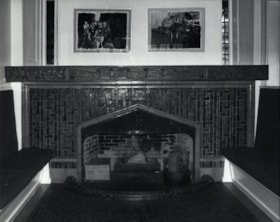
- Photograph shows the fireplace in the living room of the Burnaby Art Gallery.
- Repository
- City of Burnaby Archives
- Date
- October, 1976
- Collection/Fonds
- Burnaby Public Library Contemporary Visual Archive Project
- Physical Description
- 1 photograph : b&w ; 11 x 16 cm mounted on cardboard
- Description Level
- Item
- Record No.
- 556-446
- Access Restriction
- No restrictions
- Reproduction Restriction
- Reproduce for fair dealing purposes only
- Accession Number
- 2013-13
- Scope and Content
- Photograph shows the fireplace in the living room of the Burnaby Art Gallery.
- Subjects
- Buildings - Civic - Art Galleries
- Names
- Burnaby Art Gallery
- Media Type
- Photograph
- Photographer
- Salmon, Stu
- Notes
- Scope note taken directly from BPL photograph description.
- 1 b&w copy negative : 10 x 12.5 cm accompanying
- Geographic Access
- Deer Lake Avenue
- Gilpin Street
- Street Address
- 6344 Deer Lake Avenue
- 6344 Gilpin Street
- Historic Neighbourhood
- Burnaby Lake (Historic Neighbourhood)
- Planning Study Area
- Douglas-Gilpin Area
Images

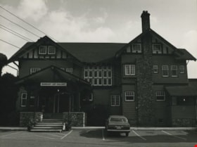
Burnaby Art Gallery
https://search.heritageburnaby.ca/link/archivedescription36265
- Repository
- City of Burnaby Archives
- Date
- 1976
- Collection/Fonds
- Burnaby Historical Society fonds
- Description Level
- Item
- Physical Description
- 1 photograph : b&w ; 18 x 24 cm, mounted on board 26 x 32.5 cm
- Scope and Content
- Photograph of the front of the Burnaby Art Gallery. There is a Datsun in the parking lot.
- Repository
- City of Burnaby Archives
- Date
- 1976
- Collection/Fonds
- Burnaby Historical Society fonds
- Subseries
- Burnaby Art Gallery subseries
- Physical Description
- 1 photograph : b&w ; 18 x 24 cm, mounted on board 26 x 32.5 cm
- Description Level
- Item
- Record No.
- 242-015
- Access Restriction
- No restrictions
- Reproduction Restriction
- Reproduce for fair dealing purposes only
- Accession Number
- BHS1990-05
- Scope and Content
- Photograph of the front of the Burnaby Art Gallery. There is a Datsun in the parking lot.
- Subjects
- Buildings - Civic - Art Galleries
- Names
- Burnaby Art Gallery
- Media Type
- Photograph
- Photographer
- Salmon, Stu
- Notes
- Photographer's note on the border of its mount reads: "S.Salmon/76"
- Geographic Access
- Deer Lake Avenue
- Street Address
- 6344 Deer Lake Avenue
- Historic Neighbourhood
- Burnaby Lake (Historic Neighbourhood)
- Planning Study Area
- Douglas-Gilpin Area
Images
