Narrow Results By
Person / Organization
- Bingham, Alfred "Alf" 2
- Bradbury, Dr. Bettina 3
- British Columbia Electric Railway Company 1
- Brownlee, James Harrison
- Burnaby Central Secondary School 1
- Canadian Institute of Mining and Metallurgy 1
- Ceperley, Grace 3
- Ceperley, H.T. 3
- Clayton, Beatrice
- Clayton, Edith 1
- Clayton, Edward 1
- Douglas Road School 1

First School at Burnaby Lake
https://search.heritageburnaby.ca/link/archivedescription39549
- Repository
- City of Burnaby Archives
- Date
- 1909
- Collection/Fonds
- Peers Family and Hill Family fonds
- Description Level
- Item
- Physical Description
- 1 photograph : b&w ; 12.5 x 17 cm on page 21.5 x 28 cm (pasted in album)
- Scope and Content
- Photograph of Harriet Woodward and her class of students outside the Woodward home near Deer Lake which served as the first school and post office in the Burnaby Lake area; (l to r): Harriet Woodward (Miss Harry), Bob Peers, Melvin Mawhinney, Muriel Sprott, Kitty Hill, Beatrice Clayton and Arthur P…
- Repository
- City of Burnaby Archives
- Date
- 1909
- Collection/Fonds
- Peers Family and Hill Family fonds
- Physical Description
- 1 photograph : b&w ; 12.5 x 17 cm on page 21.5 x 28 cm (pasted in album)
- Description Level
- Item
- Record No.
- 477-868
- Access Restriction
- No restrictions
- Reproduction Restriction
- No known restrictions
- Accession Number
- 2007-12
- Scope and Content
- Photograph of Harriet Woodward and her class of students outside the Woodward home near Deer Lake which served as the first school and post office in the Burnaby Lake area; (l to r): Harriet Woodward (Miss Harry), Bob Peers, Melvin Mawhinney, Muriel Sprott, Kitty Hill, Beatrice Clayton and Arthur Peers. The cottage was a prefabricated building designed by J.J. Mahoney and architect Joseph Bowman and was manufactured in Vancouver by the B.C. Mills Timber and Trading Company and erected here is 1904. The cottage was enlarged with several additions until 1912 when the Woodwards built a new house.
- Subjects
- Buildings - Residential - Houses
- Buildings - Public - Post Offices
- Buildings - Schools
- Occupations - Teachers
- Names
- Clayton, Beatrice
- Mawhinney, Melvin
- Peers, Arthur Francis "Mike"
- Peers, Katherine Maude Hill "Kitty"
- Peers, William John "Bob"
- Sprott, Muriel
- Woodward, Harriet
- Media Type
- Photograph
- Notes
- Title based on caption accompanying photograph
- Geographic Access
- Sperling Avenue
- Street Address
- 5141 Sperling Avenue
- Historic Neighbourhood
- Burnaby Lake (Historic Neighbourhood)
- Planning Study Area
- Morley-Buckingham Area
Images

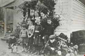
Harriet Woodward's students
https://search.heritageburnaby.ca/link/archivedescription35880
- Repository
- City of Burnaby Archives
- Date
- 1904
- Collection/Fonds
- Burnaby Historical Society fonds
- Description Level
- Item
- Physical Description
- 1 photograph : b&w ; 12.7 x 17.8 cm print
- Scope and Content
- Photograph of students of Harriet Woodward's private school, at Deer Lake. Front row, left to right: Bob Peers, Arthur Peers, Kitty Hill, Florence Hart, Geoff Peers, and Walter Gordon. Back row, left to right: Melvin Mawhinney, Beatrice Clayton, and Muriel Sprott.
- Repository
- City of Burnaby Archives
- Date
- 1904
- Collection/Fonds
- Burnaby Historical Society fonds
- Subseries
- Pioneer Tales subseries
- Physical Description
- 1 photograph : b&w ; 12.7 x 17.8 cm print
- Description Level
- Item
- Record No.
- 204-739
- Access Restriction
- No restrictions
- Reproduction Restriction
- No known restrictions
- Accession Number
- BHS1988-03
- Scope and Content
- Photograph of students of Harriet Woodward's private school, at Deer Lake. Front row, left to right: Bob Peers, Arthur Peers, Kitty Hill, Florence Hart, Geoff Peers, and Walter Gordon. Back row, left to right: Melvin Mawhinney, Beatrice Clayton, and Muriel Sprott.
- Names
- Clayton, Beatrice
- Godwin, Florence Hart
- Gordon, Walter
- Mawhinney, Melvin
- Peers, Arthur Francis "Mike"
- Peers, Geoffrey Hugh
- Peers, Katherine Maude Hill "Kitty"
- Peers, William John "Bob"
- Sprott, Muriel
- Media Type
- Photograph
- Notes
- Title based on contents of photograph
- Geographic Access
- Sperling Avenue
- Street Address
- 5141 Sperling Avenue
- Historic Neighbourhood
- Burnaby Lake (Historic Neighbourhood)
- Planning Study Area
- Morley-Buckingham Area
Images

![Survey and Subdivision plans in New Westminster District Group 1 – Burnaby
, [1908] thumbnail](/media/hpo/_Data/_BVM_Cartographic_Material/1977/1977_0093_0004a_001.jpg?width=280)
Survey and Subdivision plans in New Westminster District Group 1 – Burnaby
https://search.heritageburnaby.ca/link/museumdescription6973
- Repository
- Burnaby Village Museum
- Date
- [1908]
- Collection/Fonds
- Burnaby Village Museum Map collection
- Description Level
- File
- Physical Description
- 10 plans : blueprint ink on paper mounted on 2 sides of cardboard ; 76 cm x 102 cm
- Scope and Content
- Item consists of a large board of four New Westminster District Gp 1 - subdivision plans mounted on one side and six New Westminster District Gp 1 - subdivision plans mounted on the other side. Side A: 1. Blueprint "Plan / of - ReSubdivision / of / Lots 1-18 inclusive / Blocks 20 and 21 / in Sub…
- Repository
- Burnaby Village Museum
- Collection/Fonds
- Burnaby Village Museum Map collection
- Description Level
- File
- Physical Description
- 10 plans : blueprint ink on paper mounted on 2 sides of cardboard ; 76 cm x 102 cm
- Material Details
- Scales [between 1:792 and 1:4752]
- Index number on edge of board reads: "4"
- Scope and Content
- Item consists of a large board of four New Westminster District Gp 1 - subdivision plans mounted on one side and six New Westminster District Gp 1 - subdivision plans mounted on the other side. Side A: 1. Blueprint "Plan / of - ReSubdivision / of / Lots 1-18 inclusive / Blocks 20 and 21 / in Subdivision / of / Lot 53 -Gr.1 / New Westminster District" / "Subdivision Lot Numbers - Shown in Red". Plan is bordered by First Street / Jorgenson's Line / Fourth Avenue and Second Street with Fifith Avenue running through the centre. There is an index in the upper right corner of the plan. Planned is signed by "Peter Byrne" and "William R. Phillips" and dated July 28, 1908. (Geographic location: Burnaby) 2. Blueprint "Plan / of Subdivision / of / Lot 159 / and a Portion of Lot 158 / Group One / New Westminster District". Plan is bordered by Lots 96 and 97; South Wilson Street; North Arm Road and Lot 160 / Power House Road (Lot 155 A). B.C.E.R. Gilley Station is identified in the upper right corner of the plan. (Geographic location: Burnaby) 3. Blueprint plan identified as "Subdvs 10, L 88 and Lot 25, G. 1" Plan identifies Cumberland Street running from top to the bottom and a Ravine running alongside with the Jensen house, stable and barn. (Geographic location: Burnaby) 4. Blueprint Plan of "Lot 153. G. 1 /New Westminster District". Plan identifies the "New Westminster & Vancouver Tramway" and the "New Westminster and Vancouver Road" running through the plan of Lot 53. (Geographic location: Burnaby) Side B: 1. Blueprint plan of "Profile on Proposed North Rd. Diversion". 2. Blueprint plan (no title) showing wood lots north of Burnaby Lake and Brunette River and west of North Road. Various lots are identified as "Heavily Timbered" (Lot 57); "Splendid Fir and Cedar / Heavy Fir etc. / Fine Cedar" (Lots 143, 148); "Rough Light Timber," (Lot 56); "Some Fir and Cedar" (Lot 40). (Geographic location: Burnaby) 3. Blueprint "Plan / of Subdivision / of a Portion / of Lot 87, Gr.1 / New Westminster District". Plan is bordered by Burnaby Lake at the top and Hastings Road / Lot 86 at the bottom and Lot 90 to the east. "Albert J. Hill B.C.LotS." Annotation in ink reads: " J.A. Brownlee, B.C.L.S. / Subdivision / Map 1494 / Bd. 248". Plan is signed by "Peter Byrne, Reeve" (Geographic location: Burnaby) 4. Blueprint plan of Subdivisions along either side of Douglas Road including Lots 117; 119; 74; 80; 79 and 77. (Geographic location: Burnaby) 5. Blueprint "Plan / of / Subdivision of / Lot 27 / in Subdivision / of / Lot 30 / Group One / New Westminster District" Plan is bordered by Lot 26, Lot 28 and Hastings Rd. Lot 27 runs north of Edmonds Street. , "Albert J. Hill, B.C.LotS." (Geographic location: Burnaby) 6. Blueprint plan identified as a "Cultivated Orchard" including the names "W. Grace" and "G. Mead" located north of the North Arm Fraser River and west of "Twentieth Street_ City Boundary". Handwritten annotation in coloured pencil reads: "Portion of Lot 172" (Geographic location: Burnaby)
- Subjects
- Geographic Features - Forests
- Geographic Access
- Cumberland Street
- North Road
- Hastings Street
- Douglas Road
- Accession Code
- HV977.93.4
- Access Restriction
- No restrictions
- Reproduction Restriction
- No known restrictions
- Date
- [1908]
- Media Type
- Cartographic Material
- Historic Neighbourhood
- Burnaby Lake (Historic Neighbourhood)
- Fraser Arm (Historic Neighbourhood)
- Planning Study Area
- Douglas-Gilpin Area
- Burnaby Lake Area
- Scan Resolution
- 300
- Scale
- 72
- Notes
- Title based on contents of file
- Scale is measured in chains. (One chain equals 792 inches)
- The term "Lot" can also refer to a "District Lot”-
Images
![Survey and Subdivision plans in New Westminster District Group 1 – Burnaby
, [1908] thumbnail](/media/hpo/_Data/_BVM_Cartographic_Material/1977/1977_0093_0004a_001.jpg)
