Burnaby Lake Neighbourhood
https://search.heritageburnaby.ca/link/landmark700
- Repository
- Burnaby Heritage Planning
- Associated Dates
- 1925-1954
- Heritage Value
- After World War I and the Great Depression of the 1930s, more homes were constructed and subdivisions created in the Burnaby Lake district. The area around Deer Lake gained a reputation for being an "artistic development of commodious homes with park-like grounds."
- Historic Neighbourhood
- Burnaby Lake (Historic Neighbourhood)
- Planning Study Area
- Burnaby Lake Area
Images


Burnaby Lake Neighbourhood
https://search.heritageburnaby.ca/link/landmark755
- Repository
- Burnaby Heritage Planning
- Associated Dates
- 1905-1924
- Heritage Value
- Along with logging and sawmills, Burnaby became known as a prime agricultural area and the Burnaby Lake Neighbourhood saw the development of many vegetable and fruit farms. Growers in the Burnaby and Deer Lake districts took their produce to the tram line on Edmonds Street and shipped it to markets in New Westminster and Vancouver on a specially designed interurban freight car that was open-sided for easy loading. The car's canvas curtains which sometimes came loose and flapped like wings in the wind led people to dub it "the flying dutchman." Most Burnaby fruit and vegetable growers depended on seasonal Chinese work forces and other local Chinese farm residents to oversee operations; these workers being recruited from New Westminsters' Asian community. Besides being good farmers, Burnaby Lake's early residents fostered a strong sense of community. Both L. Claude Hill and his brother Bernard were elected to Burnaby Municipal council and Bernard was the one who knocked on doors to find enough children to meet the qualifications for establishing a school in the district.
- Historic Neighbourhood
- Burnaby Lake (Historic Neighbourhood)
- Planning Study Area
- Morley-Buckingham Area
- Lakeview-Mayfield Area
Images


Ardingley-Sprott Neighbourhood
https://search.heritageburnaby.ca/link/landmark797
- Repository
- Burnaby Heritage Planning
- Associated Dates
- 1955-2008
- Heritage Value
- The Ardingley-Sprott Neighbourhood is primarily non-residential and developed in the 1970s west of the Burnaby Lake park area. It grew to include a large recreational component in the form of the Burnaby Lake Sports Complex and playing fields.
- Historic Neighbourhood
- Burnaby Lake (Historic Neighbourhood)
- Planning Study Area
- Ardingley-Sprott Area
Images


Douglas-Gilpin Neighbourhood
https://search.heritageburnaby.ca/link/landmark799
- Repository
- Burnaby Heritage Planning
- Associated Dates
- 1955-2008
- Heritage Value
- The Douglas-Gilpin Neighbourhood developed into a diverse area incorporating residential, business, educational and park districts in the period after 1955. The BCIT site was built in the early 1960s, shortly after the Burnaby Municipal Hall was located on Canada Way near Deer Lake in 1956. The construction of the Municipal Hall at this location fostered the creation of an administrative and business centre adjacent to the park, while the northern and central areas of the neighbourhood retained their primarily residential character.
- Historic Neighbourhood
- Burnaby Lake (Historic Neighbourhood)
- Planning Study Area
- Douglas-Gilpin Area
Images


Burnaby Lake Neighbourhood
https://search.heritageburnaby.ca/link/landmark821
- Repository
- Burnaby Heritage Planning
- Associated Dates
- 1955-2008
- Heritage Value
- In 1966 Burnaby Lake was identified as a key potential regional park in the GVRD ’s Regional Park Plan for the Lower Mainland. The lake was to be developed for nature study, strolling, trail riding, canoeing, sightseeing and picnicking. It was formally recognized as a regional nature park in 1979, at which time the GVRD assumed management of the park through a lease agreement with the City of Burnaby. In 1993 Burnaby Lake was selected by the City of Burnaby to be included in Greater Vancouver ’s Green Zone, and was identified as a key component of the GVRD ’s Park and Outdoor Recreation System (PORS) for the Burrard/Peninsula/Richmond sector, which includes Burnaby, Vancouver, New Westminster, and Richmond.
- Historic Neighbourhood
- Burnaby Lake (Historic Neighbourhood)
- Planning Study Area
- Burnaby Lake Area
Images


Morley-Buckingham Neighbourhood
https://search.heritageburnaby.ca/link/landmark829
- Repository
- Burnaby Heritage Planning
- Associated Dates
- 1955-2008
- Heritage Value
- In the 1980 "Residential Neighbourhood Environment Study," the Morley-Buckingham Neighbourhood is described as "perhaps Burnaby's most prestigious residential area. The lots are larger than most other areas of the Municipality and this, along with the new expensive housing developed over the past 10 years, has created a very desirable residential neighbourhood...The older area of Buckingham lies at the lower edge of the slope and here the homes and streets are more uniform and aged between 20 and 25 years old...to the east of Canada Way lies...a cluster townhouse development."
- Historic Neighbourhood
- Burnaby Lake (Historic Neighbourhood)
- Planning Study Area
- Morley-Buckingham Area
Images


Mortimer-Lamb House
https://search.heritageburnaby.ca/link/landmark494
- Repository
- Burnaby Heritage Planning
- Description
- The Mortimer-Lamb House is a one and one half-storey, Arts and Crafts-style residence with a steeply pitched, side-gabled roof. The original cottage form has been enlarged with a later addition on the west side of the house. Located next to the Burnaby Lake Regional Park Wildlife Rescue Care Centre…
- Associated Dates
- c.1922
- Formal Recognition
- Community Heritage Register
- Other Names
- Harold & Katherine Mortimer-Lamb Residence
- Street View URL
- Google Maps Street View
- Repository
- Burnaby Heritage Planning
- Other Names
- Harold & Katherine Mortimer-Lamb Residence
- Geographic Access
- Glencarin Drive
- Associated Dates
- c.1922
- Formal Recognition
- Community Heritage Register
- Enactment Type
- Council Resolution
- Enactment Date
- 26/05/2003
- Description
- The Mortimer-Lamb House is a one and one half-storey, Arts and Crafts-style residence with a steeply pitched, side-gabled roof. The original cottage form has been enlarged with a later addition on the west side of the house. Located next to the Burnaby Lake Regional Park Wildlife Rescue Care Centre, the house has picturesque views of Burnaby Lake.
- Heritage Value
- Built circa 1922, the Mortimer-Lamb House is valued for its association with first owners, Harold Mortimer-Lamb (1872-1970), and his wife, Katherine Mary Mortimer-Lamb (1873-1939). Born in Leatherhead, Surrey, England, Harold Mortimer-Lamb immigrated to Canada in 1889. Seven years later in Vancouver, he married Katherine Mary Lindsay, a native of Winnipeg. Mortimer-Lamb was a key figure in the B.C. mining industry, serving as Secretary of the Mining Association of B.C. between 1900 and 1945, and also as the Secretary of the Canadian Institute of Mining and Metallurgy. In addition to his professional life, Mortimer-Lamb was a pioneer art photographer and was among Canada's leading art critics, and this house served as a central gathering place for renowned Canadian artists of the day. Mortimer-Lamb’s daughter, Molly Lamb Bobak (born 1922), became a renowned watercolourist, and was the only woman ever hired as an official Canadian war artist. The Mortimer-Lamb House is a significant example of the work of noted architect, Samuel Maclure (1860-1929) and his partner, Ross Lort (1889-1969). Maclure, who was a close friend of the Mortimer-Lamb family, was British Columbia's leading residential architect, and was renowned for his high quality designs for prominent citizens in both Vancouver and Victoria. Maclure was a leading exponent of the Art and Crafts design movement in B.C., and established a sophisticated local variation of residential architecture. The Mortimer-Lamb House was designed at the time when Maclure was in partnership with Ross Lort. In 1907, Lort began working for Maclure's firm as a draftsman, and by 1920 was in charge of Maclure's Vancouver office. Lort's architectural career spanned some sixty-years, and he designed some of the province's most familiar houses, apartments, institutions and places of worship. The Mortimer-Lamb House is also a significant local example of the Arts and Crafts style, and incorporates elements such as board-and-batten siding on the ground floor, shingled gables and leaded casement windows. It is a testament to the domestic architecture built outside of established suburbs during the post-First World War era, typically modest in scale and representative of middle-class residential ideals.
- Defining Elements
- Key elements that define the heritage character of the Mortimer-Lamb House include its: - treed setting with views of Burnaby Lake - residential form, scale and massing as expressed by its one and one-half storey height, rectangular plan and steeply pitched side-gabled roof - wood-frame construction - Arts and Crafts elements such as board-and-batten siding on the ground floor, cedar shingles in the gables and open soffits - original straight-leaded casement windows in single and multiple-assembly - internal red-brick chimney with corbelled cap
- Historic Neighbourhood
- Burnaby Lake (Historic Neighbourhood)
- Planning Study Area
- Burnaby Lake Area
- Organization
- Mining Association of B.C.
- G.F. and J. Galt Limited
- Architect
- Samuel Maclure
- Ross Lort
- Function
- Primary Historic--Single Dwelling
- Primary Current--Single Dwelling
- Community
- Burnaby Lake
- Cadastral Identifier
- P.I.D.002-977-788
- Boundaries
- The Mortimer-Lamb House is comprised of a single residential lot located at 5180 Glencairn Drive, Burnaby.
- Area
- 5652.78
- Contributing Resource
- Building
- Ownership
- Private
- Documentation
- City of Burnaby Planning and Building Department, Heritage Site Files
- Street Address
- 5180 Glencarin Drive
- Street View URL
- Google Maps Street View
Images


20th century typewriting : complete course
https://search.heritageburnaby.ca/link/museumlibrary5012
- Repository
- Burnaby Village Museum
- Collection
- Special Collection
- Material Type
- Book
- Accession Code
- BV007.2.1
- Call Number
- 652.3 LES
- Edition
- 6th ed.
- Place of Publication
- Cincinnati
- Publisher
- South-Western Publishing Co.
- Publication Date
- c1952
- Physical Description
- 340 p. : ill. : 20 x 28 cm.
- Library Subject (LOC)
- Typewriting
- Subjects
- Documentary Artifacts - Books
- Historic Neighbourhood
- Edmonds (Historic Neighbourhood)
- Burnaby Lake (Historic Neighbourhood)
- Planning Study Area
- Kingsway-Beresford Area
- Douglas-Gilpin Area
- Geographic Access
- Canada Way
- Southoaks Crescent
- Street Address
- 4939 Canada Way
- 6650 Southoaks Crescent
- Object History
- Was used by Burnaby resident Barbara Copan when she taught typing at Burnaby Central circa 1963-65. It may have originally belonged to Barbara's mother who also taught typing at Burnaby South High School circa 1957 to 1965. She mainly taught typing in night school.
- Notes
- Authors' given name and date as follows: Lessenberry, D.D. (David Daniel), 1896- Crawford, T. James (Thomas James)
Images


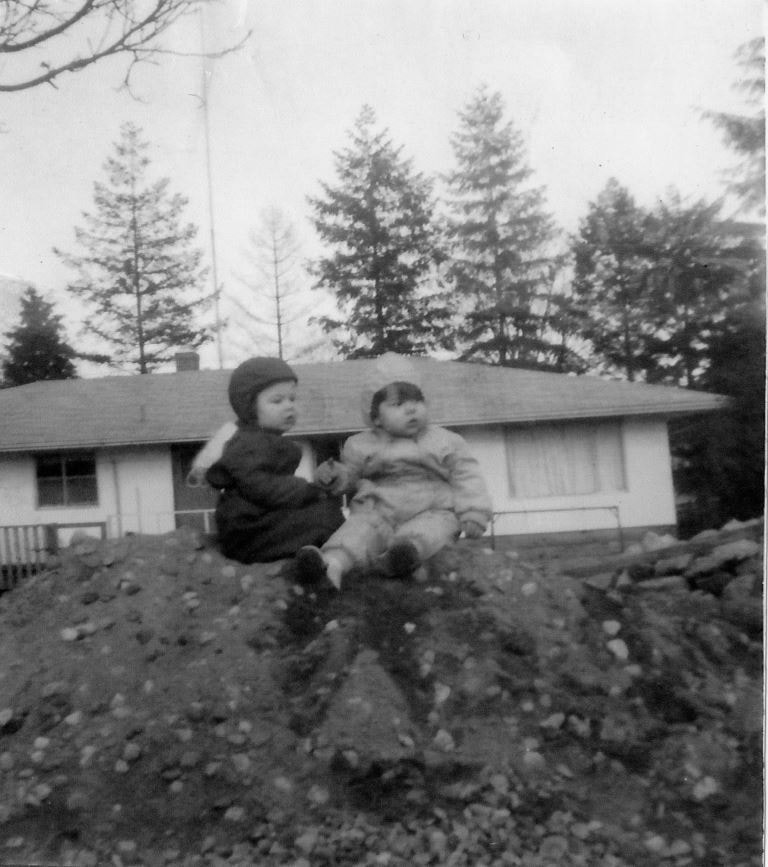
Looking east from 5493 Dominion Street
https://search.heritageburnaby.ca/link/archivedescription91841
- Repository
- City of Burnaby Archives
- Date
- 1959
- Collection/Fonds
- Small family fonds
- Description Level
- Item
- Physical Description
- 1 photograph : b&w copy print ; 11.5 cm x 10 cm
- Scope and Content
- Photograph of the Brocklebank children Brian and Pam, sitting on a dirt pile in front their single-storey house. The Hardys sold the north half of their property at 3071 Douglas Road to the Brocklebanks who built the house in 1957. The photograph was taken from 5493 (previously 3107) Dominion Str…
- Repository
- City of Burnaby Archives
- Date
- 1959
- Collection/Fonds
- Small family fonds
- Physical Description
- 1 photograph : b&w copy print ; 11.5 cm x 10 cm
- Description Level
- Item
- Record No.
- 620-022
- Access Restriction
- No restrictions
- Reproduction Restriction
- No reproduction permitted
- Accession Number
- 2017-01
- Scope and Content
- Photograph of the Brocklebank children Brian and Pam, sitting on a dirt pile in front their single-storey house. The Hardys sold the north half of their property at 3071 Douglas Road to the Brocklebanks who built the house in 1957. The photograph was taken from 5493 (previously 3107) Dominion Street, looking east.
- Media Type
- Photograph
- Notes
- Transcribed title
- Title transcribed from donor's notes
- Note in blue ink on verso of photograph reads: "P.22"
- Note in blue ink on verso of photograph reads: "Courtesy of [name]"
- Street Address
- 3071 Douglas Road
- Historic Neighbourhood
- Burnaby Lake (Historic Neighbourhood)
- Planning Study Area
- Ardingley-Sprott Area
Images
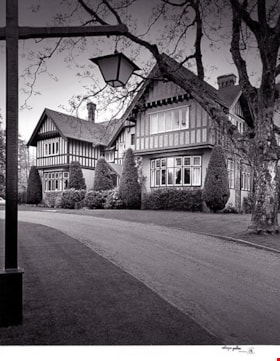
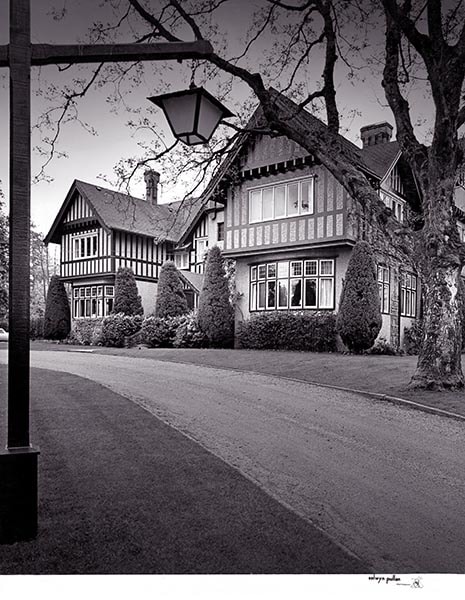
C. B. Riley Home - Western Homes & Living photographs
https://search.heritageburnaby.ca/link/archivedescription95583
- Repository
- City of Burnaby Archives
- Date
- March 1959
- Collection/Fonds
- City of Burnaby Archives photograph collection
- Description Level
- File
- Physical Description
- 2 photographs (tiff) and 3 p. of textual records (tiff, psd)
- Scope and Content
- File consists of a digitized copy of the article "Where Space is No Problem," from the March 1959 issue of Western Homes & Living Magazine, and related photographs. The article reports on the C. B. Riley home (formerly the F.J. Hart Estate "Avalon"; now Hart House) and includes floor plans and phot…
- Repository
- City of Burnaby Archives
- Date
- March 1959
- Collection/Fonds
- City of Burnaby Archives photograph collection
- Physical Description
- 2 photographs (tiff) and 3 p. of textual records (tiff, psd)
- Description Level
- File
- Record No.
- 625-001
- Access Restriction
- No restrictions
- Reproduction Restriction
- Reproduce for fair dealing purposes only
- Accession Number
- 2021-10
- Scope and Content
- File consists of a digitized copy of the article "Where Space is No Problem," from the March 1959 issue of Western Homes & Living Magazine, and related photographs. The article reports on the C. B. Riley home (formerly the F.J. Hart Estate "Avalon"; now Hart House) and includes floor plans and photographs of the house taken by Selwyn Pullan. Photographs in this file, which are also printed in the article, depict the kitchen and the exterior of the home.
- Subjects
- Buildings - Heritage
- Media Type
- Photograph
- Textual Record
- Photographer
- Pullan, Selwyn
- Notes
- Title based on content of file
- Street Address
- 6664 Deer Lake Avenue
- Historic Neighbourhood
- Burnaby Lake (Historic Neighbourhood)
- Planning Study Area
- Morley-Buckingham Area
Images
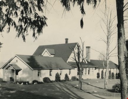
![Municipal Hall, [1959] thumbnail](/media/hpo/_Data/_Archives_Images/_Unrestricted/001/071-001.jpg?width=280)
Municipal Hall
https://search.heritageburnaby.ca/link/archivedescription34636
- Repository
- City of Burnaby Archives
- Date
- [1959]
- Collection/Fonds
- Burnaby Historical Society fonds
- Description Level
- Item
- Physical Description
- 1 photograph : b&w ; 20.2 x 25.4 cm
- Scope and Content
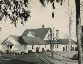
- Photograph of the exterior of Burnaby Municipal Hall at 4949 Canada Way.
- Repository
- City of Burnaby Archives
- Date
- [1959]
- Collection/Fonds
- Burnaby Historical Society fonds
- Subseries
- Photographs subseries
- Physical Description
- 1 photograph : b&w ; 20.2 x 25.4 cm
- Description Level
- Item
- Record No.
- 071-001
- Access Restriction
- No restrictions
- Reproduction Restriction
- Reproduce for fair dealing purposes only
- Accession Number
- BHS2007-04
- Scope and Content
- Photograph of the exterior of Burnaby Municipal Hall at 4949 Canada Way.
- Subjects
- Buildings - Civic - City Halls
- Names
- Burnaby City Hall
- Media Type
- Photograph
- Notes
- Title based on contents of photograph
- Geographic Access
- Canada Way
- Street Address
- 4949 Canada Way
- Historic Neighbourhood
- Burnaby Lake (Historic Neighbourhood)
- Planning Study Area
- Douglas-Gilpin Area
Images
![Municipal Hall, [1959] thumbnail](/media/hpo/_Data/_Archives_Images/_Unrestricted/001/071-001.jpg)
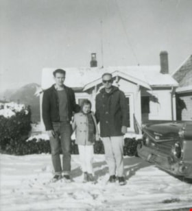
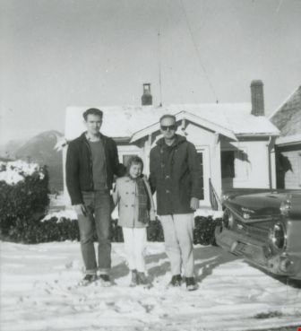
Anderson family
https://search.heritageburnaby.ca/link/archivedescription37443
- Repository
- City of Burnaby Archives
- Date
- 1959 (date of original), copied 1991
- Collection/Fonds
- Burnaby Historical Society fonds
- Description Level
- Item
- Physical Description
- 1 photograph : b&w ; 3.9 x 4.3 cm print on contact sheet 20.2 x 25.3 cm
- Scope and Content
- Photograph of the Anderson family in front of their home at 3908 Norland Avenue (originally numbered 4437 Norland Avenue) after a snowfall. Left to right: Cliff Anderson (son), Janet Anderson (daughter), and Robert "Bob" Anderson (father). To the side is a 1959 Galaxie car.
- Repository
- City of Burnaby Archives
- Date
- 1959 (date of original), copied 1991
- Collection/Fonds
- Burnaby Historical Society fonds
- Subseries
- Burnaby Image Bank subseries
- Physical Description
- 1 photograph : b&w ; 3.9 x 4.3 cm print on contact sheet 20.2 x 25.3 cm
- Description Level
- Item
- Record No.
- 370-031
- Access Restriction
- No restrictions
- Reproduction Restriction
- No restrictions
- Accession Number
- BHS1999-03
- Scope and Content
- Photograph of the Anderson family in front of their home at 3908 Norland Avenue (originally numbered 4437 Norland Avenue) after a snowfall. Left to right: Cliff Anderson (son), Janet Anderson (daughter), and Robert "Bob" Anderson (father). To the side is a 1959 Galaxie car.
- Media Type
- Photograph
- Notes
- Title based on contents of photograph
- 1 b&w copy negative accompanying
- Geographic Access
- Norland Avenue
- Street Address
- 3908 Norland Avenue
- Historic Neighbourhood
- Burnaby Lake (Historic Neighbourhood)
- Planning Study Area
- Douglas-Gilpin Area
Images

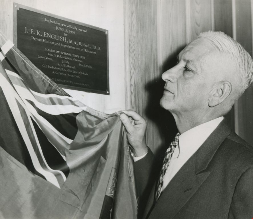
Dr. J. F. K. English
https://search.heritageburnaby.ca/link/archivedescription45218
- Repository
- City of Burnaby Archives
- Date
- June 3, 1959, published June 21, 1959
- Collection/Fonds
- Columbian Newspaper collection
- Description Level
- Item
- Physical Description
- 1 photograph : b&w ; 12 x 14 cm
- Scope and Content
- Photograph of Dr. J.F.K. English, then Deputy Minister and Superintendent of Education, unveiling the plaque that marked the official opening of Burnaby's school board offices at 5325 Kincaid.
- Repository
- City of Burnaby Archives
- Date
- June 3, 1959, published June 21, 1959
- Collection/Fonds
- Columbian Newspaper collection
- Physical Description
- 1 photograph : b&w ; 12 x 14 cm
- Description Level
- Item
- Record No.
- 480-114
- Access Restriction
- No restrictions
- Reproduction Restriction
- No restrictions
- Accession Number
- 2003-02
- Scope and Content
- Photograph of Dr. J.F.K. English, then Deputy Minister and Superintendent of Education, unveiling the plaque that marked the official opening of Burnaby's school board offices at 5325 Kincaid.
- Subjects
- Ceremonies
- Media Type
- Photograph
- Photographer
- King, Basil
- Notes
- Title based on contents of photograph
- Geographic Access
- Kincaid Street
- Street Address
- 5325 Kincaid Street
- Historic Neighbourhood
- Burnaby Lake (Historic Neighbourhood)
- Planning Study Area
- Douglas-Gilpin Area
Images
Princess Margaret's visit
https://search.heritageburnaby.ca/link/archivedescription86329
- Repository
- City of Burnaby Archives
- Date
- June 1958
- Collection/Fonds
- Richard Hardy family fonds
- Description Level
- Item
- Physical Description
- 1 photograph : b&w negative ; 4 x 5.5 cm
- Scope and Content
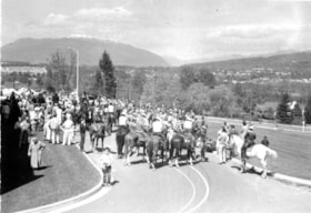
- Photograph of a crowd gathering for Princess Margaret's visit to Burnaby in June of 1958. The photograph is taken outside the municipal hall located on Grandview Highway ( later, Canada Way) which can be seen on the left. There are several people gathered on the road along with people riding horses…
- Repository
- City of Burnaby Archives
- Date
- June 1958
- Collection/Fonds
- Richard Hardy family fonds
- Physical Description
- 1 photograph : b&w negative ; 4 x 5.5 cm
- Description Level
- Item
- Record No.
- 570-008
- Access Restriction
- No restrictions
- Reproduction Restriction
- Reproduce for fair dealing purposes only
- Accession Number
- 2014-16
- Scope and Content
- Photograph of a crowd gathering for Princess Margaret's visit to Burnaby in June of 1958. The photograph is taken outside the municipal hall located on Grandview Highway ( later, Canada Way) which can be seen on the left. There are several people gathered on the road along with people riding horses. The north shore mountains can be seen in the distance.
- Subjects
- Ceremonies
- Media Type
- Photograph
- Notes
- Title based on contents of photograph
- 1 photograph : b&w ; 9 x 13 cm accompanying
- Geographic Access
- Grandview Highway
- Canada Way
- Street Address
- 4949 Canada Way
- Historic Neighbourhood
- Burnaby Lake (Historic Neighbourhood)
Images

Princess Margaret's visit
https://search.heritageburnaby.ca/link/archivedescription86438
- Repository
- City of Burnaby Archives
- Date
- June 1958
- Collection/Fonds
- Richard Hardy family fonds
- Description Level
- Item
- Physical Description
- 1 photograph : b&w negative ; 5.5 x 4 cm
- Scope and Content
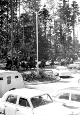
- Photograph of a automobiles, horses and a horse drawn carriage gathering for Princess Margaret's visit to Burnaby in June of 1958. The photograph is taken on the roads outside the municipal hall located on Grandview Highway ( later, Canada Way). Deer Lake park can be seen in the background.
- Repository
- City of Burnaby Archives
- Date
- June 1958
- Collection/Fonds
- Richard Hardy family fonds
- Physical Description
- 1 photograph : b&w negative ; 5.5 x 4 cm
- Description Level
- Item
- Record No.
- 570-009
- Access Restriction
- No restrictions
- Reproduction Restriction
- Reproduce for fair dealing purposes only
- Accession Number
- 2014-16
- Scope and Content
- Photograph of a automobiles, horses and a horse drawn carriage gathering for Princess Margaret's visit to Burnaby in June of 1958. The photograph is taken on the roads outside the municipal hall located on Grandview Highway ( later, Canada Way). Deer Lake park can be seen in the background.
- Subjects
- Ceremonies
- Media Type
- Photograph
- Notes
- Title based on contents of photograph
- 1 photograph : b&w ; 13 x 9 cm accompanying
- Geographic Access
- Grandview Highway
- Canada Way
- Street Address
- 4949 Canada Way
- Historic Neighbourhood
- Burnaby Lake (Historic Neighbourhood)
Images

Princess Margaret's visit
https://search.heritageburnaby.ca/link/archivedescription86444
- Repository
- City of Burnaby Archives
- Date
- June 1958
- Collection/Fonds
- Richard Hardy family fonds
- Description Level
- Item
- Physical Description
- 1 photograph : b&w negative ; 4 x 5.5 cm
- Scope and Content
- Photograph of a crowd gathering for Princess Margaret's visit to Burnaby in June of 1958. The photograph is taken outside the municipal hall located on Grandview Highway ( later, Canada Way). There are several people gathered on the road along with people riding horses. The north shore mountains ca…
- Repository
- City of Burnaby Archives
- Date
- June 1958
- Collection/Fonds
- Richard Hardy family fonds
- Physical Description
- 1 photograph : b&w negative ; 4 x 5.5 cm
- Description Level
- Item
- Record No.
- 570-010
- Access Restriction
- No restrictions
- Reproduction Restriction
- Reproduce for fair dealing purposes only
- Accession Number
- 2014-16
- Scope and Content
- Photograph of a crowd gathering for Princess Margaret's visit to Burnaby in June of 1958. The photograph is taken outside the municipal hall located on Grandview Highway ( later, Canada Way). There are several people gathered on the road along with people riding horses. The north shore mountains can be seen in the distance.
- Subjects
- Ceremonies
- Media Type
- Photograph
- Notes
- Title based on contents of photograph
- 1 photograph : b&w ; 9 x 13 cm accompanying
- Geographic Access
- Grandview Highway
- Canada Way
- Street Address
- 4949 Canada Way
- Historic Neighbourhood
- Burnaby Lake (Historic Neighbourhood)
Images


Princess Margaret's visit
https://search.heritageburnaby.ca/link/archivedescription86451
- Repository
- City of Burnaby Archives
- Date
- June 1958
- Collection/Fonds
- Richard Hardy family fonds
- Description Level
- Item
- Physical Description
- 1 photograph : b&w negative ; 4 x 5.5 cm
- Scope and Content
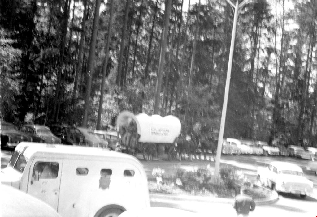
- Photograph of vehicles and a horse drawn covered wagon gathering for Princess Margaret's visit to Burnaby in June of 1958. The photograph is taken outside the municipal hall located on Grandview Highway (later, Canada Way). Deer Lake Park can be seen in the background.
- Repository
- City of Burnaby Archives
- Date
- June 1958
- Collection/Fonds
- Richard Hardy family fonds
- Physical Description
- 1 photograph : b&w negative ; 4 x 5.5 cm
- Description Level
- Item
- Record No.
- 570-011
- Access Restriction
- No restrictions
- Reproduction Restriction
- Reproduce for fair dealing purposes only
- Accession Number
- 2014-16
- Scope and Content
- Photograph of vehicles and a horse drawn covered wagon gathering for Princess Margaret's visit to Burnaby in June of 1958. The photograph is taken outside the municipal hall located on Grandview Highway (later, Canada Way). Deer Lake Park can be seen in the background.
- Subjects
- Ceremonies
- Media Type
- Photograph
- Notes
- Title based on contents of photograph
- 1 photograph : b&w ; 9 x 13 cm accompanying
- Geographic Access
- Grandview Highway
- Canada Way
- Street Address
- 4949 Canada Way
- Historic Neighbourhood
- Burnaby Lake (Historic Neighbourhood)
Images
Dania Home
https://search.heritageburnaby.ca/link/archivedescription34585
- Repository
- City of Burnaby Archives
- Date
- 1958
- Collection/Fonds
- Burnaby Historical Society fonds
- Description Level
- Item
- Physical Description
- 1 photograph : b&w ; 17.8 x 22.7 cm
- Scope and Content
- Photograph of the exterior of the Dania Home at 4279 Norland Avenue and Canada Way. The accompanying description reads, "Dania - Modern Danish Rest Home / On site pioneer estate of C.F. Sprott, one of first reeves of Burnaby, Douglas Road - near Norland." The original house, at the centre of the b…
- Repository
- City of Burnaby Archives
- Date
- 1958
- Collection/Fonds
- Burnaby Historical Society fonds
- Subseries
- Photographs subseries
- Physical Description
- 1 photograph : b&w ; 17.8 x 22.7 cm
- Description Level
- Item
- Record No.
- 059-001
- Access Restriction
- No restrictions
- Reproduction Restriction
- Reproduce for fair dealing purposes only
- Accession Number
- BHS2007-04
- Scope and Content
- Photograph of the exterior of the Dania Home at 4279 Norland Avenue and Canada Way. The accompanying description reads, "Dania - Modern Danish Rest Home / On site pioneer estate of C.F. Sprott, one of first reeves of Burnaby, Douglas Road - near Norland." The original house, at the centre of the building, was one of the earliest homes in the Burnaby Lake area, built in 1891 by Charles F. Sprott with the assistance of Bernard R. Hill.
- Names
- Dania Home
- Media Type
- Photograph
- Notes
- Title based on contents of photograph
- Geographic Access
- Norland Avenue
- Street Address
- 4279 Norland Avenue
- Historic Neighbourhood
- Burnaby Lake (Historic Neighbourhood)
- Planning Study Area
- Douglas-Gilpin Area
Images
![Forest Lawn Cemetery, [1958] thumbnail](/media/hpo/_Data/_Archives_Images/_Unrestricted/001/067-001.jpg?width=280)
Forest Lawn Cemetery
https://search.heritageburnaby.ca/link/archivedescription34631
- Repository
- City of Burnaby Archives
- Date
- [1958]
- Collection/Fonds
- Burnaby Historical Society fonds
- Description Level
- Item
- Physical Description
- 1 photograph : b&w ; 20.2 x 25.2 cm
- Scope and Content
- Photograph of Forest Lawn Cemetery at Canada Way and Royal Oak Avenue showing buildings and lawns.
- Repository
- City of Burnaby Archives
- Date
- [1958]
- Collection/Fonds
- Burnaby Historical Society fonds
- Subseries
- Photographs subseries
- Physical Description
- 1 photograph : b&w ; 20.2 x 25.2 cm
- Description Level
- Item
- Record No.
- 067-001
- Access Restriction
- No restrictions
- Reproduction Restriction
- Reproduce for fair dealing purposes only
- Accession Number
- BHS2007-04
- Scope and Content
- Photograph of Forest Lawn Cemetery at Canada Way and Royal Oak Avenue showing buildings and lawns.
- Subjects
- Cemeteries
- Media Type
- Photograph
- Notes
- Title based on contents of photograph
- Geographic Access
- Royal Oak Avenue
- Street Address
- 3789 Royal Oak Avenue
- Historic Neighbourhood
- Burnaby Lake (Historic Neighbourhood)
- Planning Study Area
- Douglas-Gilpin Area
Images
![Forest Lawn Cemetery, [1958] thumbnail](/media/hpo/_Data/_Archives_Images/_Unrestricted/001/067-001.jpg)
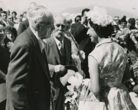
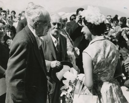
Visit of Princess Margaret
https://search.heritageburnaby.ca/link/archivedescription34665
- Repository
- City of Burnaby Archives
- Date
- 1958
- Collection/Fonds
- Burnaby Historical Society fonds
- Description Level
- Item
- Physical Description
- 1 photograph : b&w ; 20.6 x 25.4 cm
- Scope and Content
- Photograph of Princess Margaret meeting seniors outside of Burnaby's Municipal Hall at 4949 Canada Way.
- Repository
- City of Burnaby Archives
- Date
- 1958
- Collection/Fonds
- Burnaby Historical Society fonds
- Subseries
- Photographs subseries
- Physical Description
- 1 photograph : b&w ; 20.6 x 25.4 cm
- Description Level
- Item
- Record No.
- 086-001
- Access Restriction
- No restrictions
- Reproduction Restriction
- Reproduce for fair dealing purposes only
- Accession Number
- BHS2007-04
- Scope and Content
- Photograph of Princess Margaret meeting seniors outside of Burnaby's Municipal Hall at 4949 Canada Way.
- Subjects
- Events - Royal Visits
- Media Type
- Photograph
- Notes
- Title based on contents of photograph
- Geographic Access
- Canada Way
- Street Address
- 4949 Canada Way
- Historic Neighbourhood
- Burnaby Lake (Historic Neighbourhood)
- Planning Study Area
- Douglas-Gilpin Area
Images