Narrow Results By

H.T. Ceperley Estate 'Fairacres' Root House
https://search.heritageburnaby.ca/link/landmark527
- Repository
- Burnaby Heritage Planning
- Description
- The ‘Fairacres’ Root House is a long, low one-storey masonry building, measuring 4.6 metres by 9.1 metres, with massively buttressed concrete walls and foundations. Built into sloping ground adjacent to the location of the former greenhouses, the surviving orchard and the kitchen entrance of the ma…
- Associated Dates
- 1908
- Formal Recognition
- Heritage Designation, Community Heritage Register
- Repository
- Burnaby Heritage Planning
- Geographic Access
- Deer Lake Avenue
- Associated Dates
- 1908
- Formal Recognition
- Heritage Designation, Community Heritage Register
- Enactment Type
- Bylaw No. 9807
- Enactment Date
- 23/11/1992
- Description
- The ‘Fairacres’ Root House is a long, low one-storey masonry building, measuring 4.6 metres by 9.1 metres, with massively buttressed concrete walls and foundations. Built into sloping ground adjacent to the location of the former greenhouses, the surviving orchard and the kitchen entrance of the main house, 'Fairacres,' this functional structure was used as a frost-free store for fruit and vegetables for the family's use.
- Heritage Value
- The outbuildings at 'Fairacres' are a rare surviving architecturally-designed ensemble of agricultural structures that exist in complementary harmony with the main estate house. Architect Robert Mackay Fripp (1858-1917), an outspoken advocate of Arts and Crafts design, was retained by the Ceperleys to design several original outbuildings on their estate. The Root House is important as a rare surviving, and exceptionally large, example of this building type in the Vancouver region. Unusual in the fact that an architect designed a building of such modest aspirations, it is also remarkable in its method of construction. The use of concrete as a structural material is one of the earliest in the region and extraordinary for its use on such a modest vernacular outbuilding; root cellars were typically built of loose stone. Built in 1908, the Root House was significantly altered in the 1960s and restored to its original design in 2000. The building is significant as an indicator of the market gardening activity in the area around Deer Lake and of the country-house self-sufficiency practiced by the Ceperley family. The Root House illustrates the cultural, aesthetic, and lifestyle values of the Ceperleys in constructing such a large building for storing their own produce.
- Defining Elements
- The outbuildings at 'Fairacres' are a rare surviving architecturally-designed ensemble of agricultural structures that exist in complementary harmony with the main estate house. Architect Robert Mackay Fripp (1858-1917), an outspoken advocate of Arts and Crafts design, was retained by the Ceperleys to design several original outbuildings on their estate. The Root House is important as a rare surviving, and exceptionally large, example of this building type in the Vancouver region. Unusual in the fact that an architect designed a building of such modest aspirations, it is also remarkable in its method of construction. The use of concrete as a structural material is one of the earliest in the region and extraordinary for its use on such a modest vernacular outbuilding; root cellars were typically built of loose stone. Built in 1908, the Root House was significantly altered in the 1960s and restored to its original design in 2000. The building is significant as an indicator of the market gardening activity in the area around Deer Lake and of the country-house self-sufficiency practiced by the Ceperley family. The Root House illustrates the cultural, aesthetic, and lifestyle values of the Ceperleys in constructing such a large building for storing their own produce.
- Locality
- Deer Lake Park
- Historic Neighbourhood
- Burnaby Lake (Historic Neighbourhood)
- Planning Study Area
- Douglas-Gilpin Area
- Architect
- Robert Mackay Fripp
- Function
- Primary Historic--Outbuilding
- Secondary Historic--Food Storage
- Community
- Burnaby
- Cadastral Identifier
- P.I.D. No. 004-493-311 Legal Description: Block 3 Except: Part subdivided by Plan 26865, District Lot 79, Group 1, New Westminster District, Plan 536
- Boundaries
- ‘Fairacres’ is comprised of a single municipally-owned property located at 6344 Deer Lake Avenue, Burnaby.
- Area
- 17,065.00
- Contributing Resource
- Building
- Landscape Feature
- Ownership
- Public (local)
- Other Collection
- Burnaby Historical Society, Community Archives: Ceperley Photograph Album
- Documentation
- Heritage Site Files: PC77000 20. City of Burnaby Planning and Building Department, 4949 Canada Way, Burnaby, B.C., V5G 1M2
- Street Address
- 6344 Deer Lake Avenue
Images


H.T. Ceperley Estate 'Fairacres' Steam Plant Building
https://search.heritageburnaby.ca/link/landmark528
- Repository
- Burnaby Heritage Planning
- Description
- Designed in the British Arts and Crafts style, the ‘Fairacres’ Steam Plant Buiding is a single-storey wood frame building with a gabled roof that originally housed the apparatus for climate control in the greenhouses, formerly located to its north. The original rubble stone walls that formed the fo…
- Associated Dates
- 1908
- Formal Recognition
- Heritage Designation, Community Heritage Register
- Repository
- Burnaby Heritage Planning
- Geographic Access
- Deer Lake Avenue
- Associated Dates
- 1908
- Formal Recognition
- Heritage Designation, Community Heritage Register
- Enactment Type
- Bylaw No. 9807
- Enactment Date
- 23/11/1992
- Description
- Designed in the British Arts and Crafts style, the ‘Fairacres’ Steam Plant Buiding is a single-storey wood frame building with a gabled roof that originally housed the apparatus for climate control in the greenhouses, formerly located to its north. The original rubble stone walls that formed the foundation for the greenhouses stand adjacent. The Steam Plant Building stands as a pendant to the Root House, which is to the north of the former greenhouses.
- Heritage Value
- The outbuildings at 'Fairacres' are a rare surviving architecturally-designed ensemble of agricultural structures that exist in complementary harmony with the main estate house. Architect Robert Mackay Fripp (1858-1917), an outspoken advocate of Arts and Crafts design, was retained by the Ceperleys to design several original outbuildings on their estate. The Ceperleys operated 'Fairacres' with staff, a farm manager and workers, including Chinese, to grow produce for themselves and for sale at local markets. The Steam Plant Building illustrates the market gardening activity of the area around Deer Lake and its importance to the Ceperley family, which valued a year-round supply of fresh fruit and vegetables for the kitchen and flowers for the house. It also illustrates the cultural and aesthetic values of the Ceperleys in retaining an architect to design a functional outbuilding using an accepted and contemporary architectural style. Built in 1908, the Steam Plant Building was significantly altered in the 1960s and restored to its original design in 2000.
- Defining Elements
- Key elements that define the heritage character of the ‘Fairacres’ Steam Plant Building include its: - overall spatial arrangement of the Steam Plant Building in relation to the former greenhouses and the Root House - side gable roof with cedar shingle cladding. - tall brick chimney indicitive of the building's original function. - distinctive Arts and Crafts architectural features such as the shingle wall cladding with decorative shingling under window sills, deep eaves, and pebble-dashed concrete foundation walls - six-paned wooden-sash casement windows - simple functional interior features - rubble stone walls that formed the foundation for the greenhouses
- Locality
- Deer Lake Park
- Historic Neighbourhood
- Burnaby Lake (Historic Neighbourhood)
- Planning Study Area
- Douglas-Gilpin Area
- Architect
- Robert Mackay Fripp
- Function
- Primary Historic--Outbuilding
- Community
- Burnaby
- Cadastral Identifier
- P.I.D. No. 004-493-311 Legal Description: Block 3 Except: Part subdivided by Plan 26865, District Lot 79, Group 1, New Westminster District, Plan 536
- Boundaries
- ‘Fairacres’ is comprised of a single municipally-owned property located at 6344 Deer Lake Avenue, Burnaby.
- Area
- 17,065.00
- Contributing Resource
- Building
- Landscape Feature
- Ownership
- Public (local)
- Other Collection
- Burnaby Historical Society, Community Archives: Ceperley Photograph Album
- Documentation
- Heritage Site Files: PC77000 20. City of Burnaby Planning and Building Department, 4949 Canada Way, Burnaby, B.C., V5G 1M2
- Street Address
- 6344 Deer Lake Avenue
Images


H.T. Ceperley Estate 'Fairacres' Mansion
https://search.heritageburnaby.ca/link/landmark526
- Repository
- Burnaby Heritage Planning
- Description
- 'Fairacres' is a large, two-and-one-half storey estate house in the British Arts and Crafts style, located in Deer Lake Park, with four associated original outbuildings.
- Associated Dates
- 1911
- Formal Recognition
- Heritage Designation, Community Heritage Register
- Other Names
- Henry Tracy & Grace Ceperley Estate
- Burnaby Art Gallery
- Street View URL
- Google Maps Street View
- Repository
- Burnaby Heritage Planning
- Other Names
- Henry Tracy & Grace Ceperley Estate
- Burnaby Art Gallery
- Geographic Access
- Deer Lake Avenue
- Associated Dates
- 1911
- Formal Recognition
- Heritage Designation, Community Heritage Register
- Enactment Type
- Bylaw No. 9807
- Enactment Date
- 23/11/1992
- Description
- 'Fairacres' is a large, two-and-one-half storey estate house in the British Arts and Crafts style, located in Deer Lake Park, with four associated original outbuildings.
- Heritage Value
- 'Fairacres' is important as a record of the early years of Burnaby, specifically the Deer Lake area, as a place of tranquility and beautiful scenery in which the wealthy and successful in the burgeoning cities of New Westminster and Vancouver chose to retire or to make their family homes. The main house, which anchors in style and setting the outbuildings on the estate, demonstrates the social, cultural, and aesthetic values of local wealthy businessmen and women of the early twentieth century - values such as appreciation of architectural elegance and grand interior spaces, leisure and recreation, formal landscaped gardens and scenic views. Also important is the association with the English-born and trained architect Robert Mackay Fripp (1858-1917), as this was one of his grandest residential commissions. Steeped in the current architectural trends in Great Britain, Fripp designed this sprawling mansion in the Arts and Crafts style, reflected in the architectural detailing and proportions. The style was common at the time and was often used for estate mansions as a symbol of affluence and good, modern taste as well as an affinity for all things British. Quality is displayed inside and out in the finishes and materials, orchestrated by prominent local contractor, James Charles Allen, including imported English materials of specific value such as imported Medmenham tiles in the fireplace surrounds, one of the earliest documented use of these tiles outside the United Kingdom. Detailed features of the interior woodwork were carved by Scottish-born master wood carver George Selkirk Gibson (1867-1942), who was best known for his many commissions for prominent British Columbia architect Samuel Maclure. The outbuildings at 'Fairacres' are an important record of the functioning of a large estate of the time. The Garage and Stables and the Chauffeur’s Cottage accommodated the use of automobiles, horses and carriages, and in concert with the estate's location near the new British Columbia Electric Railway 'Burnaby Lake' interurban line, illustrate the evolving nature of regional transportation and the growing bedroom communities and estates made possible by increasing options for transportation. Other outbuildings accommodated the agricultural activities that helped support the Ceperley estate. The estate was conceived and funded by American-born Grace E. Dixon Ceperley (1863-1917), who had achieved significant wealth through a bequest from her brother-in-law, Vancouver pioneer Arthur Ferguson. Her husband, Henry Tracy Ceperley (1850-1929), also American-born, was a successful and well-respected businessman who made a significant contribution to the development of the City of Vancouver. The construction of 'Fairacres' spawned the transformation of the Deer Lake area from a farming community into a preferred location for elite suburban homes. 'Fairacres' is significant to the City of Burnaby as its first civic heritage conservation project. Acquired in 1966 for conversion to Burnaby’s first art gallery, it was dedicated in 1967 to mark Canada’s Centennial of Confederation.
- Defining Elements
- Key elements that define the heritage character of the ‘Fairacres’ mansion include its: - setting in relation to the gardens, its former market garden, and the vistas to Deer Lake and other grand homes in the area - side gable roof with prominent dormers and cedar shingle cladding - verandah across the eastern (garden) facade, with its view over the landscaped gardens and the distant mountains - porte cochere with its side steps for those arriving by automobile, and central raised step for those alighting from horse-drawn carriages - rich variety of exterior elements that demonstrate the typical Arts and Crafts use of local materials such as cobble stone chimneys and foundations, wide wooden siding and half-timbering - mixture of double-hung and casement wooden-sash windows, many with multi-paned sash - lavish interior spaces, designed for entertaining on a grand scale, including a billiard room with a beamed ceiling and an inglenook fireplace, and generous living and dining rooms arranged off a central hall - quality of the interior materials such as imported Medmenham tiles in fireplace surrounds, window hardware by Hope and Sons, and leaded stained glass - interior wood work including the staircase, and carvings by George Selkirk Gibson - remaining formal Edwardian garden landscape elements, including the cross-axial plan that reflects the relationship of the mansion to its 'outdoor rooms'
- Locality
- Deer Lake Park
- Historic Neighbourhood
- Burnaby Lake (Historic Neighbourhood)
- Planning Study Area
- Douglas-Gilpin Area
- Architect
- Robert Mackay Fripp
- Function
- Primary Current--Museum
- Primary Historic--Estate
- Community
- Burnaby
- Cadastral Identifier
- P.I.D. No. 004-493-311 Legal Description: Block 3 Except: Part subdivided by Plan 26865, District Lot 79, Group 1, New Westminster District, Plan 536
- Boundaries
- ‘Fairacres’ is comprised of a single municipally-owned property located at 6344 Deer Lake Avenue, Burnaby.
- Area
- 17,065.00
- Contributing Resource
- Building
- Landscape Feature
- Ownership
- Public (local)
- Other Collection
- City of Burnaby, Visual Art Collection: Original rendering by R.P.S. Twizell Burnaby Historical Society, Community Archives: Ceperley Photograph Album Burnaby Village Museum, Collection: Carved dining room panels by G.S. Gibson and other hardware items
- Documentation
- Heritage Site Files: PC77000 20. City of Burnaby Planning and Building Department, 4949 Canada Way, Burnaby, B.C., V5G 1M2
- Names
- Ceperley, Grace
- Ceperley, H.T.
- Fripp, Robert Mackay
- Allen, James Charles
- Gibson, George Selkirk
- Street Address
- 6344 Deer Lake Avenue
- Street View URL
- Google Maps Street View
Images


H.T. Ceperley Estate 'Fairacres' Chauffeur's Cottage
https://search.heritageburnaby.ca/link/landmark529
- Repository
- Burnaby Heritage Planning
- Description
- Designed in the British Arts and Crafts style, the Chauffeur's Cottage is situated across from the main entrance to the Ceperley Mansion, and adjacent to the Garage and Stables. A long, narrow single-storey building, it was constructed by joining together two modest estate cottages.
- Associated Dates
- 1911
- Formal Recognition
- Heritage Designation, Community Heritage Register
- Repository
- Burnaby Heritage Planning
- Geographic Access
- Deer Lake Avenue
- Associated Dates
- 1911
- Formal Recognition
- Heritage Designation, Community Heritage Register
- Enactment Type
- Bylaw No. 9807
- Enactment Date
- 23/11/1992
- Description
- Designed in the British Arts and Crafts style, the Chauffeur's Cottage is situated across from the main entrance to the Ceperley Mansion, and adjacent to the Garage and Stables. A long, narrow single-storey building, it was constructed by joining together two modest estate cottages.
- Heritage Value
- The outbuildings at 'Fairacres' are a rare surviving architecturally designed ensemble of agricultural structures that exist in complementary harmony with the main estate house. Architect Robert Mackay Fripp (1858-1917) was retained by the Ceperleys to design several original outbuildings on their estate at the same time as the main house was constructed. The Chauffeur's Cottage illustrates the increasing importance of the automobile in the lives of the wealthy of the early twentieth century. It also demonstrates Grace and Henry Tracy Ceperley's social aspirations and grand-country-estate pretension in having a chauffeur. The cottage's location - close to the garage and convenient, but not adjacent, to the main house - enhances the grand country house landscape design and contributes to the overall composition of the estate's plan. The Arts and Crafts styled Chauffeur's Cottage is important as an indicator of the aesthetic and social sensibilities of the Ceperley family in retaining an architect to design a modest building for staff accommodation.
- Defining Elements
- Key elements that define the heritage character of the 'Fairacres' Chauffeur's Cottage include its: - location, in relation to the main house and in close proximity to the Garage and Stables buildings - side gable roof with cedar shingle cladding - Arts and Crafts architectural features such as the jerkin-headed door hood, a reference to the thatched-roofed cottages of southern England; eight-paned wooden-sash casement windows; and cedar-shingled exterior - two internal brick chimneys - modest, functional interior, with simple trim and lack of pretension
- Locality
- Deer Lake Park
- Historic Neighbourhood
- Burnaby Lake (Historic Neighbourhood)
- Planning Study Area
- Douglas-Gilpin Area
- Architect
- Robert Mackay Fripp
- Function
- Primary Historic--Outbuilding
- Community
- Burnaby
- Cadastral Identifier
- P.I.D. No. 004-493-311 Legal Description: Block 3 Except: Part subdivided by Plan 26865, District Lot 79, Group 1, New Westminster District, Plan 536
- Boundaries
- ‘Fairacres’ is comprised of a single municipally-owned property located at 6344 Deer Lake Avenue, Burnaby.
- Area
- 17,065.00
- Contributing Resource
- Building
- Landscape Feature
- Ownership
- Public (local)
- Other Collection
- Burnaby Historical Society, Community Archives: Ceperley Photograph Album Burnaby Village Museum, Collection: Chinese ‘Tiger Whiskey’ and opium bottles found during restoration
- Documentation
- Heritage Site Files: PC77000 20. City of Burnaby Planning and Building Department, 4949 Canada Way, Burnaby, B.C., V5G 1M2
- Street Address
- 6344 Deer Lake Avenue
Images


H.T. Ceperley Estate 'Fairacres' Garage & Stables
https://search.heritageburnaby.ca/link/landmark530
- Repository
- Burnaby Heritage Planning
- Description
- Designed in the British Arts and Crafts style, the ‘Fairacres’ Garage and Stables is a two-storey wood frame building located on the 'Fairacres' estate, situated to the north of the Chauffeur's Cottage; at the south end of the structure is a single vehicle garage and to the north are several stable…
- Associated Dates
- 1911
- Formal Recognition
- Heritage Designation, Community Heritage Register
- Street View URL
- Google Maps Street View
- Repository
- Burnaby Heritage Planning
- Geographic Access
- Deer Lake Avenue
- Associated Dates
- 1911
- Formal Recognition
- Heritage Designation, Community Heritage Register
- Enactment Type
- Bylaw No. 9807
- Enactment Date
- 23/11/1992
- Description
- Designed in the British Arts and Crafts style, the ‘Fairacres’ Garage and Stables is a two-storey wood frame building located on the 'Fairacres' estate, situated to the north of the Chauffeur's Cottage; at the south end of the structure is a single vehicle garage and to the north are several stables for carriage, riding, and draught horses, a coach house, and tack room; the upper floor was originally a hay loft.
- Heritage Value
- The outbuildings at 'Fairacres' are a rare surviving architecturally designed ensemble of agricultural structures that exist in complementary harmony with the main estate house. Architect Robert Mackay Fripp (1858-1917) was retained by the Ceperleys to design several original outbuildings on their estate at the same time as the main house was constructed. The Garage and Stables building is important as a record of its era when transportation modes were in transition and the horse-drawn carriage, while still in use, was giving way to the automobile. The relative spatial arrangements within the building are a valuable indication of the economy of space associated with the automobile, as compared to the horse. The extent of the stabling arrangements signifies not only the use of carriage horses but also the continued reliance on draught horses in farming activities in this era. As well, it is an indication of the fashionable nature of equestrianism for wealthy families during this time. The building is important as a demonstration of the aesthetics of the Ceperley family in having an architect-designed outbuilding and obtaining craftsmanship and materials of the highest quality for each structure on their estate.
- Defining Elements
- Key elements that define the heritage character of the 'Fairacres' Garage and Stables include its: - location within easy reach of the main house and in close proximity to the Chauffeur's Cottage - floor plan with the garage at one end, close to the Chauffeur's Cottage, and stables and equine facilities at the other - variety and complexity of the roofline, including gable wall dormers, gable-on-hip roof ends, and half-hip extensions - Arts and Crafts architectural features of the exterior such as the shingle wall cladding articulated with a chevron-patterned course of shingles at the first floor level; casement windows; and deep eaves with additional purlins to support the overhang - original stable doors with hand-made forged-iron door hardware - multi-paned wooden-sash windows, some retaining original wire glass
- Locality
- Deer Lake Park
- Historic Neighbourhood
- Burnaby Lake (Historic Neighbourhood)
- Planning Study Area
- Douglas-Gilpin Area
- Architect
- Robert Mackay Fripp
- Function
- Primary Historic--Outbuilding
- Community
- Burnaby
- Cadastral Identifier
- P.I.D. No. 004-493-311 Legal Description: Block 3 Except: Part subdivided by Plan 26865, District Lot 79, Group 1, New Westminster District, Plan 536
- Boundaries
- ‘Fairacres’ is comprised of a single municipally-owned property located at 6344 Deer Lake Avenue, Burnaby.
- Area
- 17,065.00
- Contributing Resource
- Building
- Landscape Feature
- Ownership
- Public (local)
- Other Collection
- Burnaby Historical Society, Community Archives: Ceperley Photograph Album
- Documentation
- Heritage Site Files: PC77000 20. City of Burnaby Planning and Building Department, 4949 Canada Way, Burnaby, B.C., V5G 1M2
- Street Address
- 6344 Deer Lake Avenue
- Street View URL
- Google Maps Street View
Images


E.W. Bateman House 'Elworth'
https://search.heritageburnaby.ca/link/landmark538
- Repository
- Burnaby Heritage Planning
- Description
- The E.W. Bateman House is a one-and-one-half storey wood-frame residence set within in a garden landscape. The house and its adjacent garage are the only historic buildings standing on their original site within the Burnaby Village Museum property.
- Associated Dates
- 1922
- Formal Recognition
- Heritage Designation, Community Heritage Register
- Other Names
- Edwin & Mary Bateman Residence
- Street View URL
- Google Maps Street View
- Repository
- Burnaby Heritage Planning
- Other Names
- Edwin & Mary Bateman Residence
- Geographic Access
- Deer Lake Avenue
- Associated Dates
- 1922
- Formal Recognition
- Heritage Designation, Community Heritage Register
- Enactment Type
- Bylaw No. 9807
- Enactment Date
- 23/11/1992
- Description
- The E.W. Bateman House is a one-and-one-half storey wood-frame residence set within in a garden landscape. The house and its adjacent garage are the only historic buildings standing on their original site within the Burnaby Village Museum property.
- Heritage Value
- The E.W. Bateman House was constructed in the Deer Lake Crescent subdivision, that was originally promoted in 1911 as an upper class suburban neighbourhood. It represents one of the first residential developments in the City of Burnaby that required buildings to be of a specific value, thus demonstrating the desire for exclusivity among the successful businessmen who chose to settle in the area. The house and grounds illustrate the reduced scale of upper-class residential construction at a time of modest returning prosperity that followed the end of the First World War, and the social, cultural, lifestyle and leisure sensibilities of the owners in the Deer Lake Crescent subdivision: such values as social aspiration, racial exclusivity, demonstration of architectural taste, and importance of a landscaped garden. The heritage value of the E.W. Bateman House is its comprehensive representation of an upper middle-class suburban residence of the early 1920s. It was built for retired CPR executive Edwin Wettenhall Bateman (1859-1957) and his wife, Mary (Dale) Bateman (1865-1935), by contractor William Dodson in 1922. The Bateman House was designed by English-born and trained architect Enoch Evans (1862-1939) of E. Evans and Son, and is an important surviving residential design by Evans, and a typical example of the eclectic Period Revival influences that were common to domestic architecture in the post-First World War era. The symmetry of the imposing front verandah, supported by exaggerated Ionic columns, gives the relatively-modest house an image of grandeur and formality. Named after Edwin Bateman’s birthplace in Cheshire, England, ‘Elworth’ also symbolizes allegiance to England and the patriotic tenor of the time. The heritage value for this house also lies in its interpretive value within the Burnaby Village Museum. The site is an important cultural feature for the interpretation of Burnaby’s heritage to the public. The E.W. Bateman House was purchased by Burnaby in 1970 and became the focal point for the development of the Museum. Both the interior and exterior of the house have been restored and interpreted to the date of original construction, including recreated room interiors and period furnishings.
- Defining Elements
- The elements that define the heritage character of the E.W. Bateman House include its: - rectangular form and massing with central entry on long side - side gable roof with front shed dormer with cedar shingle cladding - symmetry of front facade - full open front verandah inset under the roofline, supported with Ionic columns - cedar shingle siding - multi-paned double-hung wooden-sash windows, mixture of 6-over-1 and 8-over-1 - symmetrical disposition of fenestration, with double-assembly units on the ground floor - exterior shutters - two flanking brick chimneys on the side elevations - interior room layouts and original interior features such as quality millwork and original hardware - original garage at the rear of the house
- Locality
- Deer Lake Park
- Historic Neighbourhood
- Burnaby Lake (Historic Neighbourhood)
- Planning Study Area
- Morley-Buckingham Area
- Organization
- Burnaby Village Museum
- Architect
- Enoch Evans
- E. Evans and Son
- Builder
- William Dodson
- Function
- Primary Current--Museum
- Primary Historic--Single Dwelling
- Community
- Burnaby
- Cadastral Identifier
- P.I.D. No. 011-030-356 Legal Description: Parcel 1, District Lot 79 and District Lot 85, Group 1, New Westminster District, Reference Plan 77594
- Boundaries
- Burnaby Village Museum is comprised of a single municipally-owned property located at 6501 Deer Lake Avenue, Burnaby.
- Area
- 38,488.63
- Contributing Resource
- Building
- Landscape Feature
- Structure
- Ownership
- Public (local)
- Documentation
- Heritage Site Files: PC77000 20. City of Burnaby Planning and Building Department, 4949 Canada Way, Burnaby, B.C., V5G 1M2
- Subjects
- Buildings - Residential
- Buildings - Residential - Houses
- Buildings - Heritage
- Buildings - Civic - Museums
- Street Address
- 6501 Deer Lake Avenue
- Street View URL
- Google Maps Street View
Images


![Elworth house, [1925] thumbnail](/media/hpo/_Data/_BVM_Images/1985/1985_1003_0001_001.jpg?width=280)
Elworth house
https://search.heritageburnaby.ca/link/museumdescription226
- Repository
- Burnaby Village Museum
- Date
- [1925]
- Collection/Fonds
- E.W. Bateman family fonds
- Description Level
- Item
- Physical Description
- 1 photograph : b&w hand-tinted into col.
- Scope and Content
- Photograph of the front of the Elworth house including the pathway to the front entrance, with beds of flowers along the path. It was built by E. W. Bateman and was his retirement house. This house is now located at the site of the Burnaby Village Museum. The photograph is hand coloured; the roof i…
- Repository
- Burnaby Village Museum
- Collection/Fonds
- E.W. Bateman family fonds
- Description Level
- Item
- Physical Description
- 1 photograph : b&w hand-tinted into col.
- Scope and Content
- Photograph of the front of the Elworth house including the pathway to the front entrance, with beds of flowers along the path. It was built by E. W. Bateman and was his retirement house. This house is now located at the site of the Burnaby Village Museum. The photograph is hand coloured; the roof is green, the pillars are cream, and the flowers are pink.
- Geographic Access
- Deer Lake Avenue
- Street Address
- 6501 Deer Lake Avenue
- Accession Code
- BV985.1003.1
- Access Restriction
- No restrictions
- Reproduction Restriction
- May be restricted by third party rights
- Date
- [1925]
- Media Type
- Photograph
- Historic Neighbourhood
- Burnaby Lake (Historic Neighbourhood)
- Planning Study Area
- Morley-Buckingham Area
- Related Material
- The photograph was originally in a frame, now numbered BV985.1003.2
- Scan Resolution
- 600
- Scan Date
- 2024-01-23
- Notes
- Title based on contents of photograph
Images
![Elworth house, [1925] thumbnail](/media/hpo/_Data/_BVM_Images/1985/1985_1003_0001_001.jpg)

Douglas Road School
https://search.heritageburnaby.ca/link/landmark573
- Repository
- Burnaby Heritage Planning
- Description
- School building.
- Associated Dates
- 1928
- Other Names
- Douglas Road Elementary School
- Street View URL
- Google Maps Street View
- Repository
- Burnaby Heritage Planning
- Other Names
- Douglas Road Elementary School
- Geographic Access
- Canada Way
- Associated Dates
- 1928
- Description
- School building.
- Heritage Value
- The Douglas Road School was originally established as a two-room school in 1908 on this site, and later expanded to four classrooms. Anticipating rapid settlement of this district, the School Board purchased two acres adjoining the old building. Two of the four rooms were designed to become one large auditorium suitable for special events and public gatherings, with seating for two hundred people. The classically-influenced school has been altered with new windows and extended with additional wings, but has retained its original red-brick veneer, tan-brick quoins and bellcast octagonal roof ventilator. Designed by McCarter & Nairne, the school was built by contractor A.S. Perry. McCarter & Nairne, who also designed the Second Street School, were the Burnaby School Board architects at this time. John Y. McCarter (1886-1981) and George Nairne (1884-1953) formed their partnership in 1921 after serving overseas during the First World War. The partners began designing houses and small apartment buildings, and their commissions included Vancouver’s first skyscraper, the Marine Building (1928-30).
- Locality
- Burnaby Lake
- Historic Neighbourhood
- Burnaby Lake (Historic Neighbourhood)
- Planning Study Area
- Douglas-Gilpin Area
- Architect
- McCarter & Nairne
- Subjects
- Buildings - Heritage
- Buildings - Schools
- Street Address
- 4861 Canada Way
- Street View URL
- Google Maps Street View
Images


![Elworth house, [1932] (date of original), copied [1974] thumbnail](/media/hpo/_Data/_BVM_Images/1974/197400900009.jpg?width=280)
Elworth house
https://search.heritageburnaby.ca/link/museumdescription972
- Repository
- Burnaby Village Museum
- Date
- [1932] (date of original), copied [1974]
- Collection/Fonds
- E.W. Bateman family fonds
- Description Level
- Item
- Physical Description
- 1 photograph : b&w ; 20.5 x 25.3 cm print
- Scope and Content
- Photograph of "Elworth," the home of Edwin W. and Mary (Dale) Bateman, at 6501 Deer Lake Avenue. The house was completed in 1922 and designated a heritage property in 1992. Photograph was taken on the occasion of Warren Stafford Bateman and Winifred Dare Webster's wedding which took place on Septe…
- Repository
- Burnaby Village Museum
- Collection/Fonds
- E.W. Bateman family fonds
- Description Level
- Item
- Physical Description
- 1 photograph : b&w ; 20.5 x 25.3 cm print
- Scope and Content
- Photograph of "Elworth," the home of Edwin W. and Mary (Dale) Bateman, at 6501 Deer Lake Avenue. The house was completed in 1922 and designated a heritage property in 1992. Photograph was taken on the occasion of Warren Stafford Bateman and Winifred Dare Webster's wedding which took place on September 21, 1932.
- Geographic Access
- Deer Lake Avenue
- Street Address
- 6501 Deer Lake Avenue
- Accession Code
- HV974.90.9
- Access Restriction
- No restrictions
- Reproduction Restriction
- No known restrictions
- Date
- [1932] (date of original), copied [1974]
- Media Type
- Photograph
- Historic Neighbourhood
- Burnaby Lake (Historic Neighbourhood)
- Planning Study Area
- Morley-Buckingham Area
- Related Material
- For a wider shot of the same exterior view, see photograph HV974.90.8
- Scan Resolution
- 600
- Scan Date
- 2023-04-25
- Notes
- Title based on contents of photograph
- 1 b&w copy negative ; 10 x 12 cm accompanying
- Stamp on verso of photograph reads: "Better Pictures / NuGloss / Photo Finish / Vancouver Drug Co. / Limited / B61"
- Note in pencil on verso of photograph reads:"3920 Douglas Rd"
Images
![Elworth house, [1932] (date of original), copied [1974] thumbnail](/media/hpo/_Data/_BVM_Images/1974/197400900009.jpg)
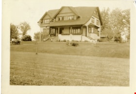
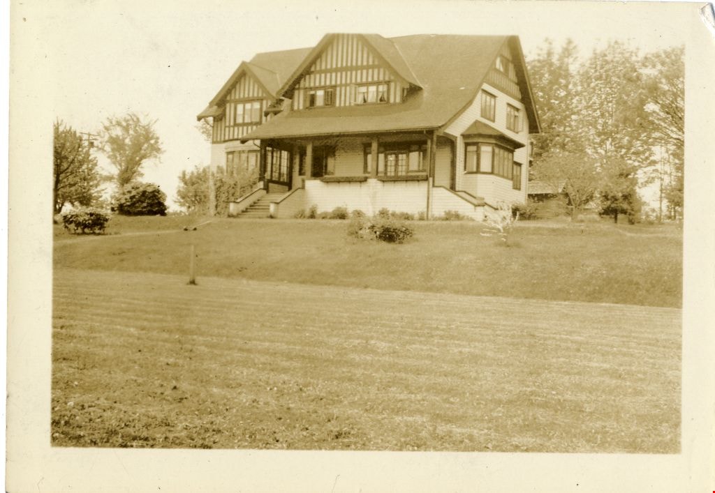
Deer Lake Avenue property
https://search.heritageburnaby.ca/link/museumdescription2665
- Repository
- Burnaby Village Museum
- Date
- 1937
- Collection/Fonds
- Hawkshaw family fonds
- Description Level
- Item
- Physical Description
- 1 photograph : sepia ; 5.5 x 8 cm
- Scope and Content
- Photograph of the Hawkshaw family home located at 3908 Deer Lake Avenue taken from the edge of the property. This house was designed by architect F.W. Macey was owned and built by R.F. Anderson in 1912.
- Repository
- Burnaby Village Museum
- Collection/Fonds
- Hawkshaw family fonds
- Description Level
- Item
- Physical Description
- 1 photograph : sepia ; 5.5 x 8 cm
- Scope and Content
- Photograph of the Hawkshaw family home located at 3908 Deer Lake Avenue taken from the edge of the property. This house was designed by architect F.W. Macey was owned and built by R.F. Anderson in 1912.
- Geographic Access
- Deer Lake Avenue
- Accession Code
- BV996.6.129
- Access Restriction
- No restrictions
- Reproduction Restriction
- No known restrictions
- Date
- 1937
- Media Type
- Photograph
- Historic Neighbourhood
- Burnaby Lake (Historic Neighbourhood)
- Planning Study Area
- Morley-Buckingham Area
- Scan Resolution
- 600
- Scan Date
- 2/9/2010
- Scale
- 100
- Notes
- Title based on contents of photograph
- Caption for photograph reads: " '1908' "
- Photograph is part of photograph album BV996.6.1
Images

Dal Hawkshaw and Pat
https://search.heritageburnaby.ca/link/museumdescription2670
- Repository
- Burnaby Village Museum
- Date
- 1937
- Collection/Fonds
- Hawkshaw family fonds
- Description Level
- Item
- Physical Description
- 1 photograph : sepia ; 5.5 x 8 cm
- Scope and Content
- Photograph of a man identified as "Pat" standing next to Dal Hawkshaw in front of the house where Mabel Hawkshaw was living in 1937. The house is located at 3908 Deer Lake Avenue (6504 Deer Lake Avenue) in Burnaby (R.F. Anderson house).
- Repository
- Burnaby Village Museum
- Collection/Fonds
- Hawkshaw family fonds
- Description Level
- Item
- Physical Description
- 1 photograph : sepia ; 5.5 x 8 cm
- Scope and Content
- Photograph of a man identified as "Pat" standing next to Dal Hawkshaw in front of the house where Mabel Hawkshaw was living in 1937. The house is located at 3908 Deer Lake Avenue (6504 Deer Lake Avenue) in Burnaby (R.F. Anderson house).
- Subjects
- Buildings - Heritage
- Geographic Access
- Deer Lake Avenue
- Accession Code
- BV996.6.134
- Access Restriction
- No restrictions
- Reproduction Restriction
- No known restrictions
- Date
- 1937
- Media Type
- Photograph
- Historic Neighbourhood
- Burnaby Lake (Historic Neighbourhood)
- Planning Study Area
- Morley-Buckingham Area
- Scan Resolution
- 600
- Scan Date
- 2/9/2010
- Scale
- 100
- Notes
- Title based on contents of photograph
- Caption for photograph reads: "Pat + Dal"
- Photograph is part of photograph album BV996.6.1
Images

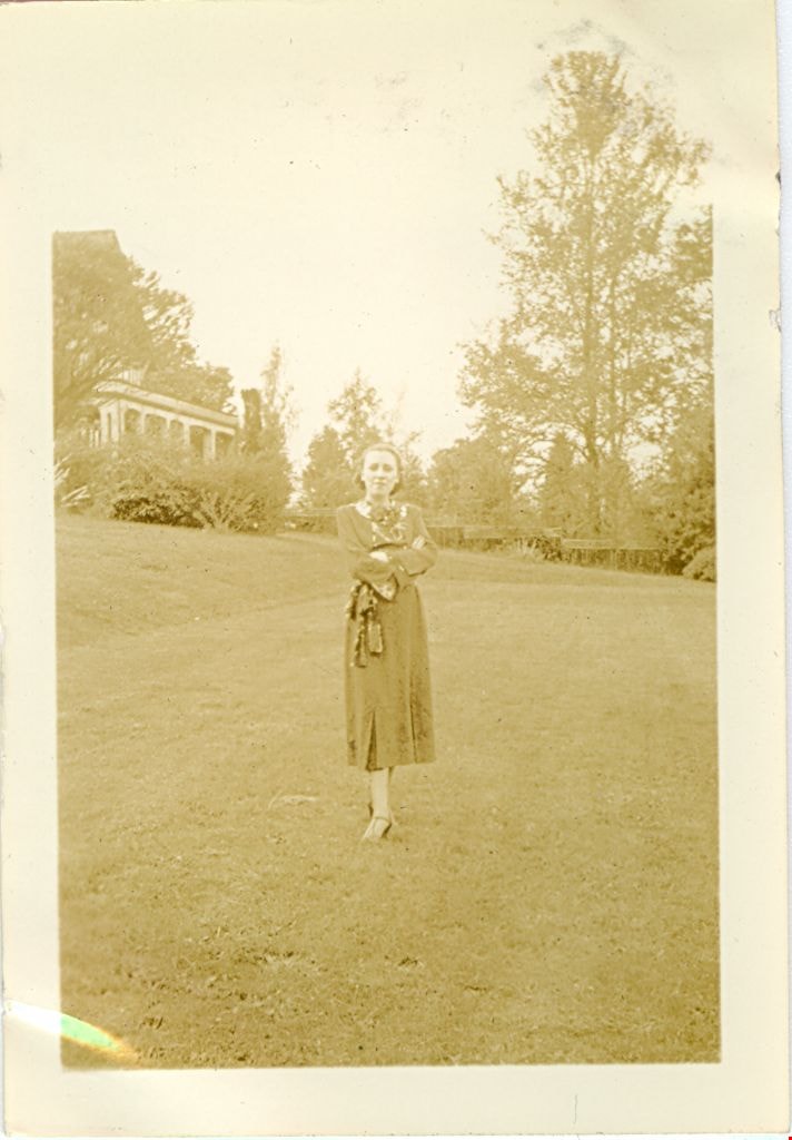
Dot
https://search.heritageburnaby.ca/link/museumdescription2707
- Repository
- Burnaby Village Museum
- Date
- 1937
- Collection/Fonds
- Hawkshaw family fonds
- Description Level
- Item
- Physical Description
- 1 photograph : sepia ; 5.5 x 8 cm
- Scope and Content
- Photograph of Dot standing on the lawn of the R.F. Anderson house located at 3908 Deer Lake Avenue (6504 Deer Lake Avenue) in Burnaby. Mabel Hawkshaw was living in this house in 1937. The Anderson House, gardens and tall trees are visible in the background.
- Repository
- Burnaby Village Museum
- Collection/Fonds
- Hawkshaw family fonds
- Description Level
- Item
- Physical Description
- 1 photograph : sepia ; 5.5 x 8 cm
- Scope and Content
- Photograph of Dot standing on the lawn of the R.F. Anderson house located at 3908 Deer Lake Avenue (6504 Deer Lake Avenue) in Burnaby. Mabel Hawkshaw was living in this house in 1937. The Anderson House, gardens and tall trees are visible in the background.
- Geographic Access
- Deer Lake Avenue
- Accession Code
- BV996.6.139
- Access Restriction
- No restrictions
- Reproduction Restriction
- No known restrictions
- Date
- 1937
- Media Type
- Photograph
- Historic Neighbourhood
- Burnaby Lake (Historic Neighbourhood)
- Planning Study Area
- Morley-Buckingham Area
- Scan Resolution
- 600
- Scan Date
- 2/18/2010
- Scale
- 100
- Notes
- Title based on contents of photograph
- Caption for photograph reads: "Dot + Me"
- Photograph is part of photograph album BV996.6.1
Images
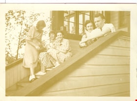
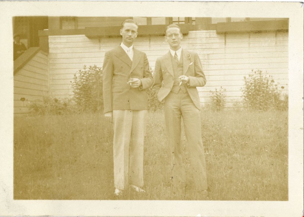
Bea, Elieen, Kay, Wilma and Colin
https://search.heritageburnaby.ca/link/museumdescription2710
- Repository
- Burnaby Village Museum
- Date
- July 24, 1937
- Collection/Fonds
- Hawkshaw family fonds
- Description Level
- Item
- Physical Description
- 1 photograph : sepia ; 5.5 x 8 cm
- Scope and Content
- Photograph of Bea, Eileen, Kay, Wilma and Colin sitting and standing together on the front steps of the Hawkshaw home located at 3908 Deer Lake Avenue (R.F. Anderson house - 6504 Deer Lake Avenue).
- Repository
- Burnaby Village Museum
- Collection/Fonds
- Hawkshaw family fonds
- Description Level
- Item
- Physical Description
- 1 photograph : sepia ; 5.5 x 8 cm
- Scope and Content
- Photograph of Bea, Eileen, Kay, Wilma and Colin sitting and standing together on the front steps of the Hawkshaw home located at 3908 Deer Lake Avenue (R.F. Anderson house - 6504 Deer Lake Avenue).
- Geographic Access
- Deer Lake Avenue
- Accession Code
- BV996.6.151
- Access Restriction
- No restrictions
- Reproduction Restriction
- No known restrictions
- Date
- July 24, 1937
- Media Type
- Photograph
- Historic Neighbourhood
- Burnaby Lake (Historic Neighbourhood)
- Planning Study Area
- Morley-Buckingham Area
- Scan Resolution
- 600
- Scan Date
- 2/18/2010
- Scale
- 100
- Notes
- Title based on contents of photograph
- Caption for photograph reads: "Bea, Eileen Kay Wilma Colin"
- Note in pencil on verso of photograph reads: "July 24/37"
- Photograph is part of photograph album BV996.6.1
Images

![Chapel at Fairacres, [between 1939 and 1954] (date of original), copied 1979 thumbnail](/media/hpo/_Data/_BVM_Images/1979/1979_0034_0002_001.jpg?width=280)
Chapel at Fairacres
https://search.heritageburnaby.ca/link/museumdescription1629
- Repository
- Burnaby Village Museum
- Date
- [between 1939 and 1954] (date of original), copied 1979
- Collection/Fonds
- Burnaby Village Museum Photograph collection
- Description Level
- Item
- Physical Description
- 1 photograph : b&w ; 20.3 x 25.2 cm print
- Scope and Content
- Photograph of the chapel of the Order of St. Benedict at the Ceperley Mansion when they purchased and occupied the mansion from 1939 to 1954. They converted the drawing room into a chapel, placing the altar in front of the fireplace. A platform with a cross on a table. The letters "LOCUS ISTE SANCT…
- Repository
- Burnaby Village Museum
- Collection/Fonds
- Burnaby Village Museum Photograph collection
- Description Level
- Item
- Physical Description
- 1 photograph : b&w ; 20.3 x 25.2 cm print
- Scope and Content
- Photograph of the chapel of the Order of St. Benedict at the Ceperley Mansion when they purchased and occupied the mansion from 1939 to 1954. They converted the drawing room into a chapel, placing the altar in front of the fireplace. A platform with a cross on a table. The letters "LOCUS ISTE SANCTUS EST" are inscribed on the wall above the cross. There is a picture of baby Jesus held by the Virgin Mary on one side of the platform, and a Saint holding a baby on the other.
- Names
- Westminster Priory
- Geographic Access
- Deer Lake Avenue
- Street Address
- 6344 Deer Lake Avenue
- Accession Code
- HV979.34.2
- Access Restriction
- Restricted access
- Reproduction Restriction
- May be restricted by third party rights
- Date
- [between 1939 and 1954] (date of original), copied 1979
- Media Type
- Photograph
- Historic Neighbourhood
- Burnaby Lake (Historic Neighbourhood)
- Planning Study Area
- Douglas-Gilpin Area
- Scan Resolution
- 600
- Scan Date
- 2023-09-12
- Notes
- Title based on contents of photograph
Images
![Chapel at Fairacres, [between 1939 and 1954] (date of original), copied 1979 thumbnail](/media/hpo/_Data/_BVM_Images/1979/1979_0034_0002_001.jpg)
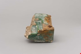
faience
https://search.heritageburnaby.ca/link/museumartifact90820
- Repository
- Burnaby Village Museum
- Accession Code
- BV020.40.11
- Description
- This is a fragment of brick or stone that was part of a fireplace hearth. A green waxy covering is present on the surfaces visible when the hearth was intact. It was three ledges or steps on one corner of the piece. There are several white markings like plaster all over the piece.
- Object History
- This is a piece of rookwood faience tile from the main floor Ceperley Mansion's fireplace before it was removed.
- Category
- 01. Built Environment Objects
- Classification
- Building Components - - Surface Elements
- Object Term
- Fireplace
- Historic Neighbourhood
- Burnaby Lake (Historic Neighbourhood)
- Planning Study Area
- Douglas-Gilpin Area
Images

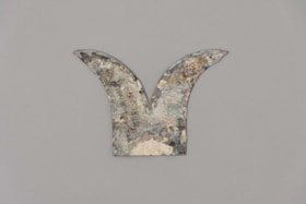
Gutter Stay
https://search.heritageburnaby.ca/link/museumartifact90822
- Repository
- Burnaby Village Museum
- Accession Code
- BV020.40.13
- Description
- Tarnished gray, brown and yellow metal piece. The base of the piece is flat with two points than curve out into opposite directions. Both points have a small hole in each tip, and one side of the base has a hole also.
- Object History
- This is a gutter stay from Hart House, used to hold the gutters in place, while being decorative.
- Category
- 01. Built Environment Objects
- Classification
- Building Components - - Plumbing & Drainage Elements
- Object Term
- Gutter
- Subjects
- Building Components
- Buildings - Heritage
- Historic Neighbourhood
- Burnaby Lake (Historic Neighbourhood)
- Planning Study Area
- Douglas-Gilpin Area
Images

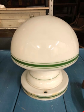
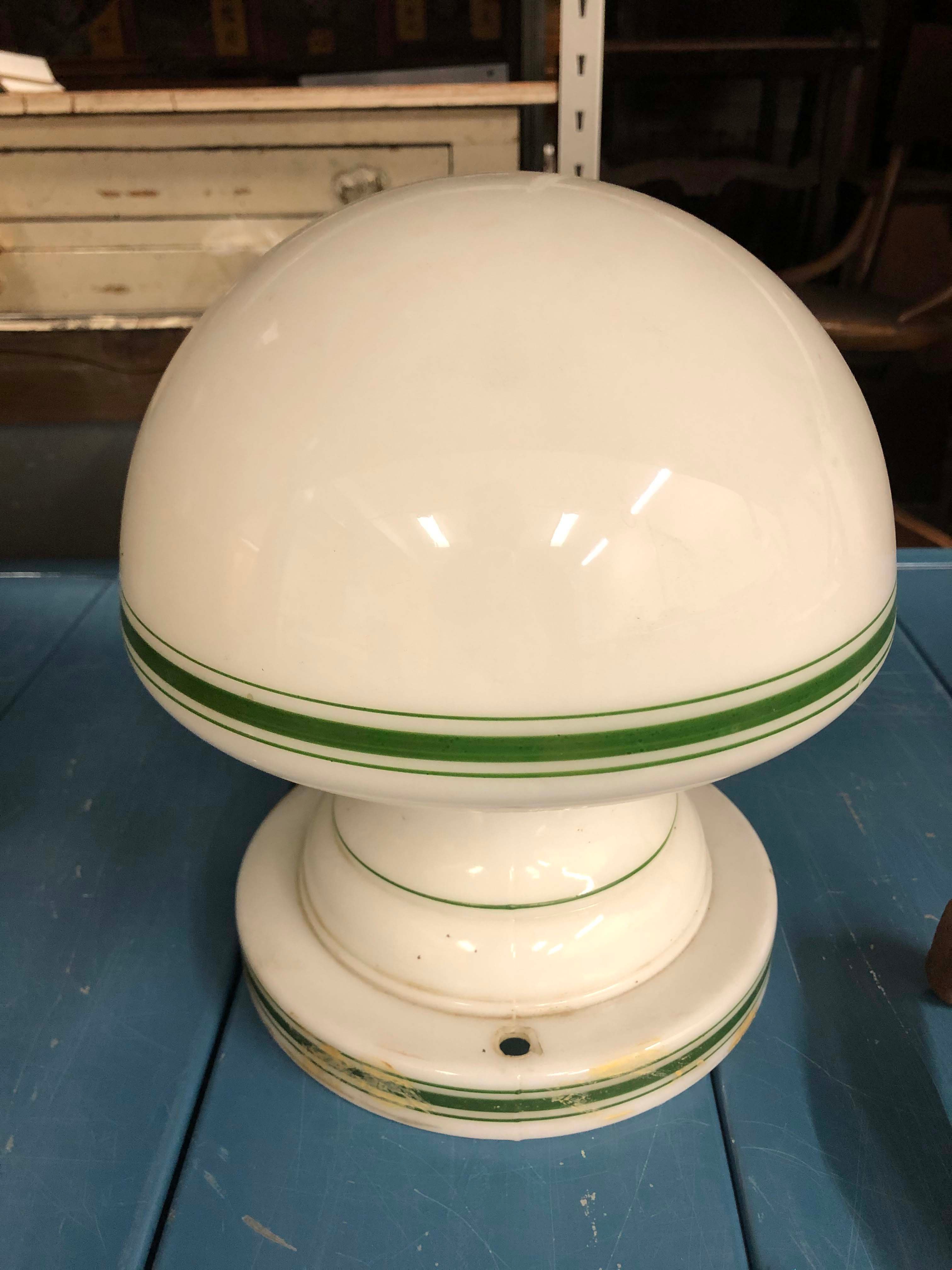
Light Fixture
https://search.heritageburnaby.ca/link/museumartifact90872
- Repository
- Burnaby Village Museum
- Accession Code
- BV020.40.23
- Description
- White glass light fixture with rounded bulb shape. The lamp and the base of the fixture hae a thick green line with two thin lines on either side. There are two holes in the base on opposite sides of each other. There is some tan/beige paint strokes around the base. An additional part is required to actually afix the lamp to the ceiling.
- Object History
- This is an original light fixture for the Eagles House. This house is located on Sperling Avenue and is under the care of the City of Burnaby Planning Department.
- Category
- 02. Furnishings
- Classification
- Lighting Equipment - - Lighting Devices
- Object Term
- Fixture, Lighting
- Colour
- White
- Green
- Historic Neighbourhood
- Burnaby Lake (Historic Neighbourhood)
- Planning Study Area
- Morley-Buckingham Area
Images
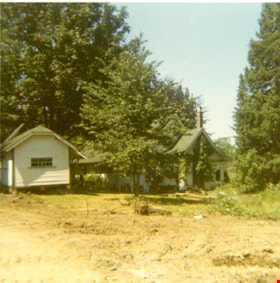
Elworth garage and Elworth house
https://search.heritageburnaby.ca/link/museumdescription13346
- Repository
- Burnaby Village Museum
- Date
- 1971
- Collection/Fonds
- Donald Copan collection
- Description Level
- Item
- Physical Description
- 1 photograph : col. ; 8.9 x 8.9 cm
- Scope and Content
- Photograph of the Elworth house (right) and Elworth garage (left). The garage has been raised up onto a wood structure and moved. The buildings are part of the Heritage Village (Burnaby Village Museum) which was Burnaby's Centennial '71 Commemorative Project. Heritage Village opened on November 19,…
- Repository
- Burnaby Village Museum
- Collection/Fonds
- Donald Copan collection
- Series
- Copan album series
- Description Level
- Item
- Physical Description
- 1 photograph : col. ; 8.9 x 8.9 cm
- Scope and Content
- Photograph of the Elworth house (right) and Elworth garage (left). The garage has been raised up onto a wood structure and moved. The buildings are part of the Heritage Village (Burnaby Village Museum) which was Burnaby's Centennial '71 Commemorative Project. Heritage Village opened on November 19, 1971.
- Names
- Burnaby Village Museum
- Accession Code
- BV005.54.364
- Access Restriction
- No restrictions
- Reproduction Restriction
- May be restricted by third party rights
- Date
- 1971
- Media Type
- Photograph
- Historic Neighbourhood
- Burnaby Lake (Historic Neighbourhood)
- Planning Study Area
- Douglas-Gilpin Area
- Scan Resolution
- 600
- Scan Date
- 4-Aug-2020
- Scale
- 100
- Notes
- Title based on contents of photograph
Images

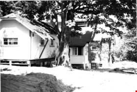
Elworth garage and Elworth house
https://search.heritageburnaby.ca/link/museumdescription13348
- Repository
- Burnaby Village Museum
- Date
- 1971
- Collection/Fonds
- Donald Copan collection
- Description Level
- Item
- Physical Description
- 1 photograph : b&w ; 8.9 x 12.7 cm
- Scope and Content
- Photograph of the Elworth house garage in foreground and Elworth house in background. The garage has been raised up onto a wood structure and moved. The buildings are part of the Heritage Village (Burnaby Village Museum) whic was Burnaby's Centennial '71 Commemorative Project. Heritage Village open…
- Repository
- Burnaby Village Museum
- Collection/Fonds
- Donald Copan collection
- Series
- Copan album series
- Description Level
- Item
- Physical Description
- 1 photograph : b&w ; 8.9 x 12.7 cm
- Scope and Content
- Photograph of the Elworth house garage in foreground and Elworth house in background. The garage has been raised up onto a wood structure and moved. The buildings are part of the Heritage Village (Burnaby Village Museum) whic was Burnaby's Centennial '71 Commemorative Project. Heritage Village opened on November 19, 1971.
- Names
- Burnaby Village Museum
- Accession Code
- BV005.54.368
- Access Restriction
- No restrictions
- Reproduction Restriction
- May be restricted by third party rights
- Date
- 1971
- Media Type
- Photograph
- Historic Neighbourhood
- Burnaby Lake (Historic Neighbourhood)
- Planning Study Area
- Douglas-Gilpin Area
- Scan Resolution
- 600
- Scan Date
- 4-Aug-2020
- Scale
- 100
- Notes
- Title based on contents of photograph
Images
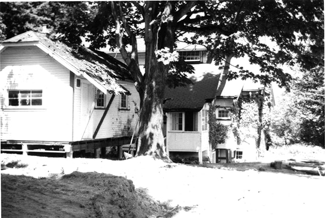
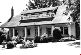
Elworth House with Centennial '71 banner
https://search.heritageburnaby.ca/link/museumdescription13349
- Repository
- Burnaby Village Museum
- Date
- 1971
- Collection/Fonds
- Donald Copan collection
- Description Level
- Item
- Physical Description
- 1 photograph : b&w ; 8.9 x 12.7 cm
- Scope and Content
- Photograph of Elworth house with "B.C. Centennial '71" banner on the future site of Heritage Village. The building was restored and formed part of Heritage Village (Burnaby Village Museum) which was Burnaby's Centennial '71 Commemorative Project. Heritage Village opened on November 19, 1971.
- Repository
- Burnaby Village Museum
- Collection/Fonds
- Donald Copan collection
- Series
- Copan album series
- Description Level
- Item
- Physical Description
- 1 photograph : b&w ; 8.9 x 12.7 cm
- Scope and Content
- Photograph of Elworth house with "B.C. Centennial '71" banner on the future site of Heritage Village. The building was restored and formed part of Heritage Village (Burnaby Village Museum) which was Burnaby's Centennial '71 Commemorative Project. Heritage Village opened on November 19, 1971.
- Names
- Burnaby Village Museum
- Accession Code
- BV005.54.369
- Access Restriction
- No restrictions
- Reproduction Restriction
- May be restricted by third party rights
- Date
- 1971
- Media Type
- Photograph
- Historic Neighbourhood
- Burnaby Lake (Historic Neighbourhood)
- Planning Study Area
- Douglas-Gilpin Area
- Scan Resolution
- 600
- Scan Date
- 4-Aug-2020
- Scale
- 100
- Notes
- Title based on contents of photograph
Images
