Narrow Results By
Subject
- Agriculture - Farms 19
- Buildings - Heritage 1
- Buildings - Religious 1
- Buildings - Residential - Houses 4
- Buildings - Schools 2
- Education 3
- First Nations reserves - British Columbia 1
- Foods 1
- Furniture 1
- Geographic Features - Gardens 3
- Geographic Features - Lakes and Ponds 4
- Geographic Features - Roads 1
![B.R. Hill house, [1910] thumbnail](/media/hpo/_Data/_BVM_Images/1976/1976_0051_0001_001.jpg?width=280)
B.R. Hill house
https://search.heritageburnaby.ca/link/museumdescription740
- Repository
- Burnaby Village Museum
- Date
- [1910]
- Collection/Fonds
- Burnaby Village Museum Photograph collection
- Description Level
- Item
- Physical Description
- 1 photograph : b&w photogravure ; 8.1 x 10.7 cm
- Scope and Content
- Photograph is photogravure printed on paper of a house on the side of a path. The area appears wooded. The inscription and the accession register identify the house as the residence of Mr. and Mrs. B.R. Hill on Douglas Road, built about 1892, with an addition to the house built about 1905.
- Repository
- Burnaby Village Museum
- Collection/Fonds
- Burnaby Village Museum Photograph collection
- Description Level
- Item
- Physical Description
- 1 photograph : b&w photogravure ; 8.1 x 10.7 cm
- Material Details
- An annotation in pencil is written on the back of the photograph
- Scope and Content
- Photograph is photogravure printed on paper of a house on the side of a path. The area appears wooded. The inscription and the accession register identify the house as the residence of Mr. and Mrs. B.R. Hill on Douglas Road, built about 1892, with an addition to the house built about 1905.
- Subjects
- Buildings - Residential - Houses
- Geographic Access
- Canada Way
- Douglas Road
- Street Address
- 4990 Canada Way
- Accession Code
- HV976.51.1
- Access Restriction
- No restrictions
- Reproduction Restriction
- May be restricted by third party rights
- Date
- [1910]
- Media Type
- Photograph
- Historic Neighbourhood
- Burnaby Lake (Historic Neighbourhood)
- Planning Study Area
- Douglas-Gilpin Area
- Scan Resolution
- 600
- Scan Date
- 2023-06-20
- Notes
- Title based on contents of photograph
Images
![B.R. Hill house, [1910] thumbnail](/media/hpo/_Data/_BVM_Images/1976/1976_0051_0001_001.jpg)
![Canoe floating on flooded farm, [1948] thumbnail](/media/hpo/_Data/_BVM_Images/2017/2017_0024_0012_001.jpg?width=280)
Canoe floating on flooded farm
https://search.heritageburnaby.ca/link/museumdescription4059
- Repository
- Burnaby Village Museum
- Date
- [1948]
- Collection/Fonds
- Julie Lee and Cecil Lee family fonds
- Description Level
- Item
- Physical Description
- 1 photograph (tiff) : sepia ; 1000 dpi
- Scope and Content
- Photograph of Suey Ying Jung (Laura) and Puy Yuen Chan in a canoe on the flooded family farm; background contains trees and a building.
- Repository
- Burnaby Village Museum
- Collection/Fonds
- Julie Lee and Cecil Lee family fonds
- Description Level
- Item
- Physical Description
- 1 photograph (tiff) : sepia ; 1000 dpi
- Scope and Content
- Photograph of Suey Ying Jung (Laura) and Puy Yuen Chan in a canoe on the flooded family farm; background contains trees and a building.
- Accession Code
- BV017.24.12
- Access Restriction
- No restrictions
- Reproduction Restriction
- No known restrictions
- Date
- [1948]
- Media Type
- Photograph
- Historic Neighbourhood
- Burnaby Lake (Historic Neighbourhood)
- Planning Study Area
- Douglas-Gilpin Area
- Scan Resolution
- 1000
- Scan Date
- 01-Oct-2017
- Scale
- 100
- Notes
- Title based on contents of photograph
Images
![Canoe floating on flooded farm, [1948] thumbnail](/media/hpo/_Data/_BVM_Images/2017/2017_0024_0012_001.jpg)
![Chapel at Fairacres, [between 1939 and 1954] (date of original), copied 1979 thumbnail](/media/hpo/_Data/_BVM_Images/1979/1979_0034_0002_001.jpg?width=280)
Chapel at Fairacres
https://search.heritageburnaby.ca/link/museumdescription1629
- Repository
- Burnaby Village Museum
- Date
- [between 1939 and 1954] (date of original), copied 1979
- Collection/Fonds
- Burnaby Village Museum Photograph collection
- Description Level
- Item
- Physical Description
- 1 photograph : b&w ; 20.3 x 25.2 cm print
- Scope and Content
- Photograph of the chapel of the Order of St. Benedict at the Ceperley Mansion when they purchased and occupied the mansion from 1939 to 1954. They converted the drawing room into a chapel, placing the altar in front of the fireplace. A platform with a cross on a table. The letters "LOCUS ISTE SANCT…
- Repository
- Burnaby Village Museum
- Collection/Fonds
- Burnaby Village Museum Photograph collection
- Description Level
- Item
- Physical Description
- 1 photograph : b&w ; 20.3 x 25.2 cm print
- Scope and Content
- Photograph of the chapel of the Order of St. Benedict at the Ceperley Mansion when they purchased and occupied the mansion from 1939 to 1954. They converted the drawing room into a chapel, placing the altar in front of the fireplace. A platform with a cross on a table. The letters "LOCUS ISTE SANCTUS EST" are inscribed on the wall above the cross. There is a picture of baby Jesus held by the Virgin Mary on one side of the platform, and a Saint holding a baby on the other.
- Names
- Westminster Priory
- Geographic Access
- Deer Lake Avenue
- Street Address
- 6344 Deer Lake Avenue
- Accession Code
- HV979.34.2
- Access Restriction
- Restricted access
- Reproduction Restriction
- May be restricted by third party rights
- Date
- [between 1939 and 1954] (date of original), copied 1979
- Media Type
- Photograph
- Historic Neighbourhood
- Burnaby Lake (Historic Neighbourhood)
- Planning Study Area
- Douglas-Gilpin Area
- Scan Resolution
- 600
- Scan Date
- 2023-09-12
- Notes
- Title based on contents of photograph
Images
![Chapel at Fairacres, [between 1939 and 1954] (date of original), copied 1979 thumbnail](/media/hpo/_Data/_BVM_Images/1979/1979_0034_0002_001.jpg)
![Deer Lake, [1914] thumbnail](/media/hpo/_Data/_BVM_Images/1971/197200110006.jpg?width=280)
Deer Lake
https://search.heritageburnaby.ca/link/museumdescription3092
- Repository
- Burnaby Village Museum
- Date
- [1914]
- Collection/Fonds
- Burnaby Village Museum Photograph collection
- Description Level
- Item
- Physical Description
- 1 photograph : b&w glass negative ; 16.0 x 20.9 cm
- Scope and Content
- Photograph of the north shore of Deer Lake looking northwest. According to a 1988 catalogue record, visible is the T.O. Townley house, "Deerholme," and the Gardener's cottage (marred by a stain). Ceperley's "Fairacres" is also visible to the extreme right of the contact print, including a boathous…
- Repository
- Burnaby Village Museum
- Collection/Fonds
- Burnaby Village Museum Photograph collection
- Description Level
- Item
- Physical Description
- 1 photograph : b&w glass negative ; 16.0 x 20.9 cm
- Scope and Content
- Photograph of the north shore of Deer Lake looking northwest. According to a 1988 catalogue record, visible is the T.O. Townley house, "Deerholme," and the Gardener's cottage (marred by a stain). Ceperley's "Fairacres" is also visible to the extreme right of the contact print, including a boathouse on the shore which can be seen on the centre of the print.
- Geographic Access
- Price Street
- Deer Lake
- Street Address
- 6110 Price Street
- Accession Code
- HV972.11.6
- Access Restriction
- No restrictions
- Reproduction Restriction
- No known restrictions
- Date
- [1914]
- Media Type
- Photograph
- Historic Neighbourhood
- Burnaby Lake (Historic Neighbourhood)
- Planning Study Area
- Morley-Buckingham Area
- Related Material
- For other shots of the Deer Lake in the same accession, see HV972.11.16 and HV972.11.18
- Scan Resolution
- 300
- Scan Date
- 14/8/2006
- Scale
- 100
- Notes
- Title based on contents of photograph
- 1 b&w contact print accompanying negative
Images
![Deer Lake, [1914] thumbnail](/media/hpo/_Data/_BVM_Images/1971/197200110006.jpg)

Deer Lake
https://search.heritageburnaby.ca/link/museumdescription3102
- Repository
- Burnaby Village Museum
- Date
- 1914
- Collection/Fonds
- Burnaby Village Museum Photograph collection
- Description Level
- Item
- Physical Description
- 1 photograph : b&w glass negative ; 16.0 x 20.9 cm
- Scope and Content
- Photograph of Deer Lake. An earlier catalogue record from 1988 notes that the view is of the north shore of Deer Lake, looking northeast. Also noted is that the Hart's boathouse is in view at the mouth of Deer Lake Brook, and that the Anderson and Mathers houses on can be seen on Deer Lake Avenue
- Repository
- Burnaby Village Museum
- Collection/Fonds
- Burnaby Village Museum Photograph collection
- Description Level
- Item
- Physical Description
- 1 photograph : b&w glass negative ; 16.0 x 20.9 cm
- Scope and Content
- Photograph of Deer Lake. An earlier catalogue record from 1988 notes that the view is of the north shore of Deer Lake, looking northeast. Also noted is that the Hart's boathouse is in view at the mouth of Deer Lake Brook, and that the Anderson and Mathers houses on can be seen on Deer Lake Avenue
- Geographic Access
- Deer Lake Avenue
- Deer Lake Brook
- Street Address
- 6490 Deer Lake Avenue
- 6344 Deer Lake Avenue
- 6450 Deer Lake Avenue
- Accession Code
- HV972.11.16
- Access Restriction
- No restrictions
- Reproduction Restriction
- No known restrictions
- Date
- 1914
- Media Type
- Photograph
- Historic Neighbourhood
- Burnaby Lake (Historic Neighbourhood)
- Planning Study Area
- Douglas-Gilpin Area
- Related Material
- For other shots of the Deer Lake in the same accession, see HV972.11.6 and HV972.11.18
- Scan Resolution
- 300
- Scan Date
- 14/8/2006
- Scale
- 100
- Notes
- Title based on contents of photograph
- 1 b&w contact print accompanying negative
Images

![Deer Lake, [1914] thumbnail](/media/hpo/_Data/_BVM_Images/1971/197200110018.jpg?width=280)
Deer Lake
https://search.heritageburnaby.ca/link/museumdescription3104
- Repository
- Burnaby Village Museum
- Date
- [1914]
- Collection/Fonds
- Burnaby Village Museum Photograph collection
- Description Level
- Item
- Physical Description
- 1 photograph : b&w glass negative ; 16.4 x 21.2 cm
- Scope and Content
- Photograph of the north shore of Deer Lake as seen from the south shore. According to an earlier 1988 catalogue record, in view from left to right are: H.T. Ceperley's "Fairacres," The Mathers "Altnadene," and the Anderson house on the hill. On shoreline are the Hart's boathouse and beach cottage…
- Repository
- Burnaby Village Museum
- Collection/Fonds
- Burnaby Village Museum Photograph collection
- Description Level
- Item
- Physical Description
- 1 photograph : b&w glass negative ; 16.4 x 21.2 cm
- Scope and Content
- Photograph of the north shore of Deer Lake as seen from the south shore. According to an earlier 1988 catalogue record, in view from left to right are: H.T. Ceperley's "Fairacres," The Mathers "Altnadene," and the Anderson house on the hill. On shoreline are the Hart's boathouse and beach cottage and the Woodward's boathouse.
- Geographic Access
- Deer Lake Avenue
- Street Address
- 6490 Deer Lake Avenue
- 6344 Deer Lake Avenue
- Accession Code
- HV972.11.18
- Access Restriction
- No restrictions
- Reproduction Restriction
- No known restrictions
- Date
- [1914]
- Media Type
- Photograph
- Historic Neighbourhood
- Burnaby Lake (Historic Neighbourhood)
- Planning Study Area
- Lakeview-Mayfield Area
- Related Material
- For other shots of the Deer Lake in the same accession, see HV972.11.6 and HV972.11.16
- Scan Resolution
- 300
- Scan Date
- 14/8/2006
- Scale
- 100
- Notes
- Title based on contents of photograph
- 1 b&w contact print accompanying negative
Images
![Deer Lake, [1914] thumbnail](/media/hpo/_Data/_BVM_Images/1971/197200110018.jpg)
![Deer Lake Drive, [1918] thumbnail](/media/hpo/_Data/_BVM_Images/1972/1972_0051_0012_001.jpg?width=280)
Deer Lake Drive
https://search.heritageburnaby.ca/link/museumdescription1085
- Repository
- Burnaby Village Museum
- Date
- [1918]
- Collection/Fonds
- Burnaby Village Museum Photograph collection
- Description Level
- Item
- Physical Description
- 1 photograph : b&w ; 12.9 x 32.9 cm
- Scope and Content
- Photograph is a panorama of Deer Lake Drive, including the Ceperley mansion and the surrounding grounds of the home to the left of the picture. The photograph, taken from the water tower, with Burnaby Lake in the background. In the midground, following the horizon line, power poles can be seen. Far…
- Repository
- Burnaby Village Museum
- Collection/Fonds
- Burnaby Village Museum Photograph collection
- Description Level
- Item
- Physical Description
- 1 photograph : b&w ; 12.9 x 32.9 cm
- Scope and Content
- Photograph is a panorama of Deer Lake Drive, including the Ceperley mansion and the surrounding grounds of the home to the left of the picture. The photograph, taken from the water tower, with Burnaby Lake in the background. In the midground, following the horizon line, power poles can be seen. Farm lands are visible leading down to the homes of the Andersons. An annotation on the back of the photo in pencil reads, "Deer Lake Dr." and an annotation in blue pen reads, "1918."
- Geographic Access
- Deer Lake Drive
- Deer Lake Avenue
- Street Address
- 6344 Deer Lake Avenue
- Accession Code
- HV972.51.12
- Access Restriction
- No restrictions
- Reproduction Restriction
- No known restrictions
- Date
- [1918]
- Media Type
- Photograph
- Historic Neighbourhood
- Burnaby Lake (Historic Neighbourhood)
- Planning Study Area
- Douglas-Gilpin Area
- Scan Resolution
- 600
- Scan Date
- 2023-04-04
Images
![Deer Lake Drive, [1918] thumbnail](/media/hpo/_Data/_BVM_Images/1972/1972_0051_0012_001.jpg)

Douglas Road School site
https://search.heritageburnaby.ca/link/museumdescription11136
- Repository
- Burnaby Village Museum
- Date
- April 19, 1915
- Collection/Fonds
- Ronald G. Scobbie collection
- Description Level
- Item
- Physical Description
- 1 survey plan : blueprint on paper ; 56 x 54 cm
- Scope and Content
- Survey plan of "Douglas Road School Site / Burnaby Municipality" "Being Lot 21, of Blocks 1-5 inc. 11 & 12 of the subd. of north half of Lot 80, Group 1, New Westminster District".
- Repository
- Burnaby Village Museum
- Collection/Fonds
- Ronald G. Scobbie collection
- Description Level
- Item
- Physical Description
- 1 survey plan : blueprint on paper ; 56 x 54 cm
- Material Details
- Scale 40 feet = 1 inch
- Scope and Content
- Survey plan of "Douglas Road School Site / Burnaby Municipality" "Being Lot 21, of Blocks 1-5 inc. 11 & 12 of the subd. of north half of Lot 80, Group 1, New Westminster District".
- Creator
- McGugan, Donald Johnston
- Subjects
- Buildings - Schools
- Names
- Douglas Road School
- Responsibility
- Burnett & McGugan, Engineers and Surveyors
- Geographic Access
- Canada Way
- Street Address
- 4861 Canada Way
- Accession Code
- BV003.83.15
- Access Restriction
- No restrictions
- Reproduction Restriction
- No known restrictions
- Date
- April 19, 1915
- Media Type
- Cartographic Material
- Historic Neighbourhood
- Burnaby Lake (Historic Neighbourhood)
- Planning Study Area
- Douglas-Gilpin Area
- Scan Resolution
- 440
- Scan Date
- 22-Dec-2020
- Scale
- 100
- Notes
- Title based on contents of plan
- Note in black ink on verso of plan reads: "1747"
- Oath on plan reads: "I, D.G. McGugan..." "...and did person- ally superintend the survey..." "...completed on the 3rd day of April 1915"; signed by D.J. McGugan, notarized by "H.A. Eastman", sworn "...19th day of April 1915" "Burnett and McGugan" "B.C. Land Surveyors Etc. New Westminster, B.C.."
Images

![Douglas Road School students, [between 1940 and 1942] thumbnail](/media/hpo/_Data/_BVM_Images/2017/201700280031_001.jpg?width=280)
Douglas Road School students
https://search.heritageburnaby.ca/link/museumdescription4234
- Repository
- Burnaby Village Museum
- Date
- [between 1940 and 1942]
- Collection/Fonds
- Burnaby Village Museum Photograph collection
- Description Level
- Item
- Physical Description
- 1 photograph : b&w ; 13 x 18 cm
- Scope and Content
- Photograph of students from Douglas Road School, possibly grade seven or eight class. Students and a male teacher are standing and sitting in front of a outside wooden staircase. There are 10 female students and 11 male students. Glen Boal is seated in the front row, third from the right.
- Repository
- Burnaby Village Museum
- Collection/Fonds
- Burnaby Village Museum Photograph collection
- Description Level
- Item
- Physical Description
- 1 photograph : b&w ; 13 x 18 cm
- Material Details
- Handwritten text on back of photograph reads: 'Glen Boal seated front row / 3d from right".
- Scope and Content
- Photograph of students from Douglas Road School, possibly grade seven or eight class. Students and a male teacher are standing and sitting in front of a outside wooden staircase. There are 10 female students and 11 male students. Glen Boal is seated in the front row, third from the right.
- Subjects
- Persons - Students
- Geographic Access
- Canada Way
- Street Address
- 4861 Canada Way
- Accession Code
- BV017.28.31
- Access Restriction
- No restrictions
- Reproduction Restriction
- No known restrictions
- Date
- [between 1940 and 1942]
- Media Type
- Photograph
- Historic Neighbourhood
- Burnaby Lake (Historic Neighbourhood)
- Planning Study Area
- Douglas-Gilpin Area
- Scan Resolution
- 600
- Scan Date
- 06-Mar-2018
- Notes
- Title based on contents of photograph
Images
![Douglas Road School students, [between 1940 and 1942] thumbnail](/media/hpo/_Data/_BVM_Images/2017/201700280031_001.jpg)
![Douglas Road School students, [between 1938 and 1940] thumbnail](/media/hpo/_Data/_BVM_Images/2017/201700280032_001.jpg?width=280)
Douglas Road School students
https://search.heritageburnaby.ca/link/museumdescription4235
- Repository
- Burnaby Village Museum
- Date
- [between 1938 and 1940]
- Collection/Fonds
- Burnaby Village Museum Photograph collection
- Description Level
- Item
- Physical Description
- 1 photograph : b&w ; 13 x 18 cm
- Scope and Content
- Photograph of students from Douglas Road School, elementary grade. This is possibly a combined class as there are two teachers in the photo and 51 students. The students are in four rows with a male teacher at either end of the third row. Glen Boal is at the left end of the third row standing next …
- Repository
- Burnaby Village Museum
- Collection/Fonds
- Burnaby Village Museum Photograph collection
- Description Level
- Item
- Physical Description
- 1 photograph : b&w ; 13 x 18 cm
- Material Details
- Handwritten text on back of photograph reads: 'Glen Boal / 3d Row far left beside teacher".
- Scope and Content
- Photograph of students from Douglas Road School, elementary grade. This is possibly a combined class as there are two teachers in the photo and 51 students. The students are in four rows with a male teacher at either end of the third row. Glen Boal is at the left end of the third row standing next to a teacher.
- Subjects
- Persons - Students
- Geographic Access
- Canada Way
- Street Address
- 4861 Canada Way
- Accession Code
- BV017.28.32
- Access Restriction
- No restrictions
- Reproduction Restriction
- No known restrictions
- Date
- [between 1938 and 1940]
- Media Type
- Photograph
- Historic Neighbourhood
- Burnaby Lake (Historic Neighbourhood)
- Planning Study Area
- Douglas-Gilpin Area
- Scan Resolution
- 600
- Scan Date
- 06-Mar-2018
- Notes
- Title based on contents of photograph
Images
![Douglas Road School students, [between 1938 and 1940] thumbnail](/media/hpo/_Data/_BVM_Images/2017/201700280032_001.jpg)
![Edie and Maureen Fleming, [ca. 1940s] thumbnail](/media/Hpo/_Data/_BVM_Images/2016/2016_0046_0106_001.jpg?width=280)
Edie and Maureen Fleming
https://search.heritageburnaby.ca/link/museumdescription5151
- Repository
- Burnaby Village Museum
- Date
- [ca. 1940s]
- Collection/Fonds
- Waplington family fonds
- Description Level
- Item
- Physical Description
- 1 photograph : b&w ; 8.5 x 6 cm
- Scope and Content
- Photograph of Edith (Edie) and Maureen Fleming hugging near a tree in the yard of the Waplington/Fleming home located at 3813 Deer Lake Avenue.
- Repository
- Burnaby Village Museum
- Collection/Fonds
- Waplington family fonds
- Description Level
- Item
- Physical Description
- 1 photograph : b&w ; 8.5 x 6 cm
- Scope and Content
- Photograph of Edith (Edie) and Maureen Fleming hugging near a tree in the yard of the Waplington/Fleming home located at 3813 Deer Lake Avenue.
- Geographic Access
- Deer Lake Avenue
- Street Address
- 3813 Deer Lake Avenue
- Accession Code
- BV016.46.106
- Access Restriction
- No restrictions
- Reproduction Restriction
- No known restrictions
- Date
- [ca. 1940s]
- Media Type
- Photograph
- Historic Neighbourhood
- Burnaby Lake (Historic Neighbourhood)
- Planning Study Area
- Morley-Buckingham Area
- Scan Resolution
- 600
- Scan Date
- 13-Aug-2018
- Notes
- Title based on information from photograph album
- Photograph is part of Photograph album BV016.46.52
Images
![Edie and Maureen Fleming, [ca. 1940s] thumbnail](/media/Hpo/_Data/_BVM_Images/2016/2016_0046_0106_001.jpg)
![Edie Fleming, [ca. 1940s] thumbnail](/media/Hpo/_Data/_BVM_Images/2016/2016_0046_0107_001.jpg?width=280)
Edie Fleming
https://search.heritageburnaby.ca/link/museumdescription5152
- Repository
- Burnaby Village Museum
- Date
- [ca. 1940s]
- Collection/Fonds
- Waplington family fonds
- Description Level
- Item
- Physical Description
- 1 photograph : b&w ; 8.5 x 6 cm
- Scope and Content
- Photograph of Edith (Edie) in the yard of the Waplington/Fleming home located at 3813 Deer Lake Avenue. Edith is wearing overalls and has one hand in her pocket.
- Repository
- Burnaby Village Museum
- Collection/Fonds
- Waplington family fonds
- Description Level
- Item
- Physical Description
- 1 photograph : b&w ; 8.5 x 6 cm
- Scope and Content
- Photograph of Edith (Edie) in the yard of the Waplington/Fleming home located at 3813 Deer Lake Avenue. Edith is wearing overalls and has one hand in her pocket.
- Geographic Access
- Deer Lake Avenue
- Street Address
- 3813 Deer Lake Avenue
- Accession Code
- BV016.46.107
- Access Restriction
- No restrictions
- Reproduction Restriction
- No known restrictions
- Date
- [ca. 1940s]
- Media Type
- Photograph
- Historic Neighbourhood
- Burnaby Lake (Historic Neighbourhood)
- Planning Study Area
- Morley-Buckingham Area
- Scan Resolution
- 600
- Scan Date
- 13-Aug-2018
- Notes
- Title based on information from photograph album
- Photograph is part of Photograph album BV016.46.52
Images
![Edie Fleming, [ca. 1940s] thumbnail](/media/Hpo/_Data/_BVM_Images/2016/2016_0046_0107_001.jpg)
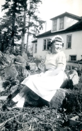
Edie Fleming
https://search.heritageburnaby.ca/link/museumdescription5154
- Repository
- Burnaby Village Museum
- Date
- 1949
- Collection/Fonds
- Waplington family fonds
- Description Level
- Item
- Physical Description
- 1 photograph : b&w ; 21 x 8 cm
- Scope and Content
- Photograph of Edith (Edie) Fleming seated on a rock outside the Waplington/Fleming home located at 3813 Deer Lake Avenue. Edith is dressed in white with a floral crown for church on Easter Sunday.
- Repository
- Burnaby Village Museum
- Collection/Fonds
- Waplington family fonds
- Description Level
- Item
- Physical Description
- 1 photograph : b&w ; 21 x 8 cm
- Scope and Content
- Photograph of Edith (Edie) Fleming seated on a rock outside the Waplington/Fleming home located at 3813 Deer Lake Avenue. Edith is dressed in white with a floral crown for church on Easter Sunday.
- Subjects
- Holidays - Easter
- Geographic Access
- Deer Lake Avenue
- Street Address
- 3813 Deer Lake Avenue
- Accession Code
- BV016.46.109
- Access Restriction
- No restrictions
- Reproduction Restriction
- No known restrictions
- Date
- 1949
- Media Type
- Photograph
- Historic Neighbourhood
- Burnaby Lake (Historic Neighbourhood)
- Planning Study Area
- Morley-Buckingham Area
- Scan Resolution
- 600
- Scan Date
- 13-Aug-2018
- Notes
- Title based on information from photograph album
- Note in black ink on verso of photograph reads: "Taken by Ray / Edith / Easter 1949"
- Photograph is part of Photograph album BV016.46.52
Images

![Flooded Chan family farm, [1948] thumbnail](/media/hpo/_Data/_BVM_Images/2017/2017_0024_0023_001.jpg?width=280)
Flooded Chan family farm
https://search.heritageburnaby.ca/link/museumdescription4069
- Repository
- Burnaby Village Museum
- Date
- [1948]
- Collection/Fonds
- Julie Lee and Cecil Lee family fonds
- Description Level
- Item
- Physical Description
- 1 photograph (tiff) : sepia ; 1000 dpi
- Scope and Content
- Photograph of Suey Ying Jung (Laura) and Puy Yuen Chan in a canoe on the flooded family farm; background contains trees and two buildings; foreground contains a hedge.
- Repository
- Burnaby Village Museum
- Collection/Fonds
- Julie Lee and Cecil Lee family fonds
- Description Level
- Item
- Physical Description
- 1 photograph (tiff) : sepia ; 1000 dpi
- Scope and Content
- Photograph of Suey Ying Jung (Laura) and Puy Yuen Chan in a canoe on the flooded family farm; background contains trees and two buildings; foreground contains a hedge.
- Accession Code
- BV017.24.23
- Access Restriction
- No restrictions
- Reproduction Restriction
- No known restrictions
- Date
- [1948]
- Media Type
- Photograph
- Historic Neighbourhood
- Burnaby Lake (Historic Neighbourhood)
- Planning Study Area
- Douglas-Gilpin Area
- Scan Resolution
- 1000
- Scan Date
- 01-Oct-2017
- Scale
- 100
- Notes
- Title based on contents of photograph
Images
![Flooded Chan family farm, [1948] thumbnail](/media/hpo/_Data/_BVM_Images/2017/2017_0024_0023_001.jpg)
![Flooded Chan family farm, [1948] thumbnail](/media/hpo/_Data/_BVM_Images/2017/201700240024_001.jpg?width=280)
Flooded Chan family farm
https://search.heritageburnaby.ca/link/museumdescription4070
- Repository
- Burnaby Village Museum
- Date
- [1948]
- Collection/Fonds
- Julie Lee and Cecil Lee family fonds
- Description Level
- Item
- Physical Description
- 1 photograph (tiff) : sepia ; 1000 dpi
- Scope and Content
- Photograph of the flooded Chan family farm; buildings and telephone poles throughout the landscape.
- Repository
- Burnaby Village Museum
- Collection/Fonds
- Julie Lee and Cecil Lee family fonds
- Description Level
- Item
- Physical Description
- 1 photograph (tiff) : sepia ; 1000 dpi
- Scope and Content
- Photograph of the flooded Chan family farm; buildings and telephone poles throughout the landscape.
- Accession Code
- BV017.24.24
- Access Restriction
- No restrictions
- Reproduction Restriction
- No known restrictions
- Date
- [1948]
- Media Type
- Photograph
- Historic Neighbourhood
- Burnaby Lake (Historic Neighbourhood)
- Planning Study Area
- Douglas-Gilpin Area
- Scan Resolution
- 1000
- Scan Date
- 01-Oct-2017
- Scale
- 100
- Notes
- Title based on contents of photograph
Images
![Flooded Chan family farm, [1948] thumbnail](/media/hpo/_Data/_BVM_Images/2017/201700240024_001.jpg)
![Fraser Valley Nurseries, [191-?] (date of original), copied 1977 thumbnail](/media/hpo/_Data/_BVM_Images/1977/1977_0099_0017_001.jpg?width=280)
Fraser Valley Nurseries
https://search.heritageburnaby.ca/link/museumdescription575
- Repository
- Burnaby Village Museum
- Date
- [191-?] (date of original), copied 1977
- Collection/Fonds
- Burnaby Village Museum Photograph collection
- Description Level
- Item
- Physical Description
- 1 photograph : b&w ; 20.32 x 25.4 cm
- Scope and Content
- Photograph of the grounds of the Fraser Valley Nurseries. The grounds are fenced with wire and wooden posts.There is a large sign on the left of the photograph that reads "The Fraser Valley Nurseries, Ltd." There are a few barns or sheds on the nursery grounds. Behind the nursery can be seen a la…
- Repository
- Burnaby Village Museum
- Collection/Fonds
- Burnaby Village Museum Photograph collection
- Description Level
- Item
- Physical Description
- 1 photograph : b&w ; 20.32 x 25.4 cm
- Scope and Content
- Photograph of the grounds of the Fraser Valley Nurseries. The grounds are fenced with wire and wooden posts.There is a large sign on the left of the photograph that reads "The Fraser Valley Nurseries, Ltd." There are a few barns or sheds on the nursery grounds. Behind the nursery can be seen a large body of water, most likely Burnaby Lake. The accession register and the inscription on the photograph identify the location as just off Douglas Road (now Canada Way). The annotation on the back of the photograph reads: "Located off Canada Way."
- Subjects
- Agriculture - Farms
- Names
- Fraser Valley Nurseries
- Geographic Access
- Douglas Road
- Canada Way
- Nursery Street
- Burnaby Lake
- Accession Code
- HV977.99.17
- Access Restriction
- No restrictions
- Reproduction Restriction
- May be restricted by third party rights
- Date
- [191-?] (date of original), copied 1977
- Media Type
- Photograph
- Historic Neighbourhood
- Burnaby Lake (Historic Neighbourhood)
- Planning Study Area
- Lakeview-Mayfield Area
- Related Material
- For the right side of the two part panorama of the nurseries, see HV977.99.19
- Scan Resolution
- 600
- Scan Date
- 2023-07-11
- Notes
- Title based on contents of photograph
Images
![Fraser Valley Nurseries, [191-?] (date of original), copied 1977 thumbnail](/media/hpo/_Data/_BVM_Images/1977/1977_0099_0017_001.jpg)
![Fraser Valley Nurseries, [191-?] (date of original), copied 1977 thumbnail](/media/hpo/_Data/_BVM_Images/1977/1977_0099_0019_001.jpg?width=280)
Fraser Valley Nurseries
https://search.heritageburnaby.ca/link/museumdescription577
- Repository
- Burnaby Village Museum
- Date
- [191-?] (date of original), copied 1977
- Collection/Fonds
- Burnaby Village Museum Photograph collection
- Description Level
- Item
- Physical Description
- 1 photograph : b&w ; 20.2 x 25.2 cm print
- Scope and Content
- Photograph of the grounds of the Fraser Valley Nurseries. The grounds are fenced with wire and wooden posts. There are a few barns or sheds on the nursery grounds. Behind the nursery can be seen a large body of water, most likely Burnaby Lake. The accession register identifies the location as j…
- Repository
- Burnaby Village Museum
- Collection/Fonds
- Burnaby Village Museum Photograph collection
- Description Level
- Item
- Physical Description
- 1 photograph : b&w ; 20.2 x 25.2 cm print
- Scope and Content
- Photograph of the grounds of the Fraser Valley Nurseries. The grounds are fenced with wire and wooden posts. There are a few barns or sheds on the nursery grounds. Behind the nursery can be seen a large body of water, most likely Burnaby Lake. The accession register identifies the location as just off Douglas Road (now Canada Way). An annotation on the back of the photo reads: "View Fraser Valley Nurseries."
- Subjects
- Agriculture - Farms
- Names
- Fraser Valley Nurseries
- Geographic Access
- Douglas Road
- Canada Way
- Nursery Street
- Burnaby Lake
- Accession Code
- HV977.99.19
- Access Restriction
- No restrictions
- Reproduction Restriction
- May be restricted by third party rights
- Date
- [191-?] (date of original), copied 1977
- Media Type
- Photograph
- Historic Neighbourhood
- Burnaby Lake (Historic Neighbourhood)
- Planning Study Area
- Lakeview-Mayfield Area
- Related Material
- For the left side of the two part panorama of the nurseries, see HV977.99.17
- Scan Resolution
- 600
- Scan Date
- 2023-07-11
- Notes
- Title based on contents of photograph
Images
![Fraser Valley Nurseries, [191-?] (date of original), copied 1977 thumbnail](/media/hpo/_Data/_BVM_Images/1977/1977_0099_0019_001.jpg)
![Gordon and Harry Jung with Philip Mah, [between 1935 and 1945] thumbnail](/media/hpo/_Data/_BVM_Images/2021/2021_0019_0003_001.jpg?width=280)
Gordon and Harry Jung with Philip Mah
https://search.heritageburnaby.ca/link/museumdescription16728
- Repository
- Burnaby Village Museum
- Date
- [between 1935 and 1945]
- Collection/Fonds
- Julie Lee and Cecil Lee family fonds
- Description Level
- Item
- Physical Description
- 1 photograph (jpg)
- Scope and Content
- Photograph of Suey Yook "Gordon" Jung and Suey Cheung "Harry" Jung standing with young, Philip Mah on the boardwalk outside the Jung family home located on the family farm at 5460 Douglas Road (address was changed to 5286 Douglas Road in 1958) in Burnaby. Philip Mah is the son of Lil Mah.
- Repository
- Burnaby Village Museum
- Collection/Fonds
- Julie Lee and Cecil Lee family fonds
- Description Level
- Item
- Physical Description
- 1 photograph (jpg)
- Scope and Content
- Photograph of Suey Yook "Gordon" Jung and Suey Cheung "Harry" Jung standing with young, Philip Mah on the boardwalk outside the Jung family home located on the family farm at 5460 Douglas Road (address was changed to 5286 Douglas Road in 1958) in Burnaby. Philip Mah is the son of Lil Mah.
- Geographic Access
- Vancouver
- Street Address
- 5286 Douglas Road
- Accession Code
- BV021.19.3
- Access Restriction
- No restrictions
- Reproduction Restriction
- No known restrictions
- Date
- [between 1935 and 1945]
- Media Type
- Photograph
- Historic Neighbourhood
- Burnaby Lake (Historic Neighbourhood)
- Planning Study Area
- Douglas-Gilpin Area
- Scan Resolution
- 96
- Scan Date
- April 13, 2021
- Scale
- 100
- Notes
- Title based on contents of photograph
Images
![Gordon and Harry Jung with Philip Mah, [between 1935 and 1945] thumbnail](/media/hpo/_Data/_BVM_Images/2021/2021_0019_0003_001.jpg)
![Gordon Jung and Gee Shee Jung, [between 1935 and 1945] thumbnail](/media/hpo/_Data/_BVM_Images/2021/2021_0019_0001_001.jpg?width=280)
Gordon Jung and Gee Shee Jung
https://search.heritageburnaby.ca/link/museumdescription16726
- Repository
- Burnaby Village Museum
- Date
- [between 1935 and 1945]
- Collection/Fonds
- Julie Lee and Cecil Lee family fonds
- Description Level
- Item
- Physical Description
- 1 photograph (jpg)
- Scope and Content
- Photograph of Suey Yook "Gordon" Jung standing with his mother, Gee Shee Jung on the family farm located at 5460 Douglas Road in Burnaby (address was changed to 5286 Douglas Road in 1958).
- Repository
- Burnaby Village Museum
- Collection/Fonds
- Julie Lee and Cecil Lee family fonds
- Description Level
- Item
- Physical Description
- 1 photograph (jpg)
- Scope and Content
- Photograph of Suey Yook "Gordon" Jung standing with his mother, Gee Shee Jung on the family farm located at 5460 Douglas Road in Burnaby (address was changed to 5286 Douglas Road in 1958).
- Geographic Access
- Vancouver
- Street Address
- 5286 Douglas Road
- Accession Code
- BV021.19.1
- Access Restriction
- No restrictions
- Reproduction Restriction
- No known restrictions
- Date
- [between 1935 and 1945]
- Media Type
- Photograph
- Historic Neighbourhood
- Burnaby Lake (Historic Neighbourhood)
- Planning Study Area
- Douglas-Gilpin Area
- Scan Resolution
- 96
- Scan Date
- April 13, 2021
- Scale
- 100
- Notes
- Title based on contents of photograph
Images
![Gordon Jung and Gee Shee Jung, [between 1935 and 1945] thumbnail](/media/hpo/_Data/_BVM_Images/2021/2021_0019_0001_001.jpg)
![Gordon Jung and Herbert Yep, [between 1935 and 1945] thumbnail](/media/hpo/_Data/_BVM_Images/2021/2021_0019_0004_001.jpg?width=280)
Gordon Jung and Herbert Yep
https://search.heritageburnaby.ca/link/museumdescription16730
- Repository
- Burnaby Village Museum
- Date
- [between 1935 and 1945]
- Collection/Fonds
- Julie Lee and Cecil Lee family fonds
- Description Level
- Item
- Physical Description
- 1 photograph (jpg)
- Scope and Content
- Photograph of Suey Yook "Gordon" Jung and Herbert Yep standing together on the boardwalk outside the Jung family home located on the family farm at 5460 Douglas Road (address was changed to 5286 Douglas Road in 1958) in Burnaby.
- Repository
- Burnaby Village Museum
- Collection/Fonds
- Julie Lee and Cecil Lee family fonds
- Description Level
- Item
- Physical Description
- 1 photograph (jpg)
- Scope and Content
- Photograph of Suey Yook "Gordon" Jung and Herbert Yep standing together on the boardwalk outside the Jung family home located on the family farm at 5460 Douglas Road (address was changed to 5286 Douglas Road in 1958) in Burnaby.
- Geographic Access
- Vancouver
- Street Address
- 5286 Douglas Road
- Accession Code
- BV021.19.4
- Access Restriction
- No restrictions
- Reproduction Restriction
- No known restrictions
- Date
- [between 1935 and 1945]
- Media Type
- Photograph
- Historic Neighbourhood
- Burnaby Lake (Historic Neighbourhood)
- Planning Study Area
- Douglas-Gilpin Area
- Scan Resolution
- 96
- Scan Date
- April 13, 2021
- Scale
- 100
- Notes
- Title based on contents of photograph
Images
![Gordon Jung and Herbert Yep, [between 1935 and 1945] thumbnail](/media/hpo/_Data/_BVM_Images/2021/2021_0019_0004_001.jpg)