Narrow Results By

Douglas Road School site
https://search.heritageburnaby.ca/link/museumdescription11136
- Repository
- Burnaby Village Museum
- Date
- April 19, 1915
- Collection/Fonds
- Ronald G. Scobbie collection
- Description Level
- Item
- Physical Description
- 1 survey plan : blueprint on paper ; 56 x 54 cm
- Scope and Content
- Survey plan of "Douglas Road School Site / Burnaby Municipality" "Being Lot 21, of Blocks 1-5 inc. 11 & 12 of the subd. of north half of Lot 80, Group 1, New Westminster District".
- Repository
- Burnaby Village Museum
- Collection/Fonds
- Ronald G. Scobbie collection
- Description Level
- Item
- Physical Description
- 1 survey plan : blueprint on paper ; 56 x 54 cm
- Material Details
- Scale 40 feet = 1 inch
- Scope and Content
- Survey plan of "Douglas Road School Site / Burnaby Municipality" "Being Lot 21, of Blocks 1-5 inc. 11 & 12 of the subd. of north half of Lot 80, Group 1, New Westminster District".
- Creator
- McGugan, Donald Johnston
- Subjects
- Buildings - Schools
- Names
- Douglas Road School
- Responsibility
- Burnett & McGugan, Engineers and Surveyors
- Geographic Access
- Canada Way
- Street Address
- 4861 Canada Way
- Accession Code
- BV003.83.15
- Access Restriction
- No restrictions
- Reproduction Restriction
- No known restrictions
- Date
- April 19, 1915
- Media Type
- Cartographic Material
- Historic Neighbourhood
- Burnaby Lake (Historic Neighbourhood)
- Planning Study Area
- Douglas-Gilpin Area
- Scan Resolution
- 440
- Scan Date
- 22-Dec-2020
- Scale
- 100
- Notes
- Title based on contents of plan
- Note in black ink on verso of plan reads: "1747"
- Oath on plan reads: "I, D.G. McGugan..." "...and did person- ally superintend the survey..." "...completed on the 3rd day of April 1915"; signed by D.J. McGugan, notarized by "H.A. Eastman", sworn "...19th day of April 1915" "Burnett and McGugan" "B.C. Land Surveyors Etc. New Westminster, B.C.."
Images

Municipal Council
https://search.heritageburnaby.ca/link/archivedescription55631
- Repository
- City of Burnaby Archives
- Date
- 1956
- Collection/Fonds
- Charles MacSorley fonds
- Description Level
- Item
- Physical Description
- 1 photograph : b&w ; 20.5 x 25.5 cm
- Scope and Content
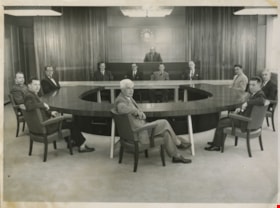
- Photograph of the 1956 Burnaby Municipal Council in Council Chambers at Burnaby Municipal Hall. Identified in the photograph are (starting at centre, forefront and moving clockwise): Gerald Charlton, Fred Philps, Wesley Morrison, Arnold Hean, Ted Ward (Deputy Municipal Clerk), John Shaw (Municipal…
- Repository
- City of Burnaby Archives
- Date
- 1956
- Collection/Fonds
- Charles MacSorley fonds
- Physical Description
- 1 photograph : b&w ; 20.5 x 25.5 cm
- Description Level
- Item
- Record No.
- 486-025
- Access Restriction
- No restrictions
- Reproduction Restriction
- Reproduce for fair dealing purposes only
- Accession Number
- 2005-14
- Scope and Content
- Photograph of the 1956 Burnaby Municipal Council in Council Chambers at Burnaby Municipal Hall. Identified in the photograph are (starting at centre, forefront and moving clockwise): Gerald Charlton, Fred Philps, Wesley Morrison, Arnold Hean, Ted Ward (Deputy Municipal Clerk), John Shaw (Municipal Clerk), Reeve Charles MacSorley (in the back), two unkown members of staff, Samuel Hughes, William Philps and Doug Drummond.
- Subjects
- Officials - Alderman and Councillors
- Officials - Mayors and Reeves
- Buildings - Civic - City Halls
- Occupations - City Clerks
- Occupations - Civic Workers
- Names
- Charlton, Gerald
- Philps, Fred
- Morrison, Wesley
- Hean, Arnold F.C.
- Ward, Ted
- Shaw, John Horace "Jack"
- MacSorley, Charles W.
- Hughes, Samuel E.
- Philps, William P.
- Drummond, John D. "Doug"
- Media Type
- Photograph
- Photographer
- Cunningham, W.
- Notes
- Title based on contents of photograph
- Photographer's stamp on verso
- Notes on verso identify the people in the photograph
- Geographic Access
- Canada Way
- Street Address
- 4949 Canada Way
- Historic Neighbourhood
- Burnaby Lake (Historic Neighbourhood)
- Planning Study Area
- Douglas-Gilpin Area
Images
