Narrow Results By
Decade
- 2020s 2
- 2010s 5
- 2000s 28
- 1990s 131
- 1980s 173
- 1970s 295
- 1960s 355
- 1950s 568
- 1940s 735
- 1930s 725
- 1920s 1001
- 1910s 734
- 1900s
- 1890s
- 1880s 10
- 1870s 8
- 1860s 10
- 1850s 5
- 1840s 3
- 1830s 2
- 1820s 2
- 1810s 3
- 1800s 3
- 1790s 2
- 1780s 2
- 1770s 2
- 1760s 2
- 1750s 2
- 1740s 2
- 1730s 2
- 1720s 2
- 1710s 2
- 1700s 2
- 1690s 2
- 1680s 2
- 1670s 1
- 1660s 1
- 1650s 1
- 1640s 1
- 1630s 1
- 1620s 1
- 1610s 1
- 1600s 1
- 1590s 1
- 1580s 1
- 1570s 1
- 1560s 1
- 1550s 1
- 1540s 1
- 1530s 1
- 1520s 1
- 1510s
- 1500s 1
- 1490s 1
- 1480s 1
![Agricultural Exhibit, [1909] thumbnail](/media/hpo/_Data/_Archives_Images/_Unrestricted/001/041-001.jpg?width=280)
Agricultural Exhibit
https://search.heritageburnaby.ca/link/archivedescription34530
- Repository
- City of Burnaby Archives
- Date
- [1909]
- Collection/Fonds
- Burnaby Historical Society fonds
- Description Level
- Item
- Physical Description
- 1 photograph : b&w ; 20.4 x 25.2 cm
- Scope and Content
- Photograph of Burnaby's Agricultural Exhibit at New Westminster showing a display of vegetables, fruit, flowers, plants, and trees inside of a building.
- Repository
- City of Burnaby Archives
- Date
- [1909]
- Collection/Fonds
- Burnaby Historical Society fonds
- Subseries
- Photographs subseries
- Physical Description
- 1 photograph : b&w ; 20.4 x 25.2 cm
- Description Level
- Item
- Record No.
- 041-001
- Access Restriction
- No restrictions
- Reproduction Restriction
- No known restrictions
- Accession Number
- BHS2007-04
- Scope and Content
- Photograph of Burnaby's Agricultural Exhibit at New Westminster showing a display of vegetables, fruit, flowers, plants, and trees inside of a building.
- Subjects
- Agriculture - Crops
- Exhibitions - Agricultural
- Agriculture - Fruit and Berries
- Plants - Flowers
- Media Type
- Photograph
- Notes
- Title based on contents of photograph
Images
![Agricultural Exhibit, [1909] thumbnail](/media/hpo/_Data/_Archives_Images/_Unrestricted/001/041-001.jpg)
![St. Alban's Anglican Church, [1909] (date of original), copied 1986 thumbnail](/media/hpo/_Data/_Archives_Images/_Unrestricted/126/171-024.jpg?width=280)
St. Alban's Anglican Church
https://search.heritageburnaby.ca/link/archivedescription35003
- Repository
- City of Burnaby Archives
- Date
- [1909] (date of original), copied 1986
- Collection/Fonds
- Burnaby Historical Society fonds
- Description Level
- Item
- Physical Description
- 1 photograph : b&w postcard ; 8.5 x 11.8 cm
- Scope and Content
- Photograph on a postcard of the exterior of St. Alban's Anglican Church at 7717 19th Avenue, near Douglas Road (now Canada Way) and Edmonds Street.
- Repository
- City of Burnaby Archives
- Date
- [1909] (date of original), copied 1986
- Collection/Fonds
- Burnaby Historical Society fonds
- Subseries
- Patterson family subseries
- Physical Description
- 1 photograph : b&w postcard ; 8.5 x 11.8 cm
- Description Level
- Item
- Record No.
- 171-024
- Access Restriction
- No restrictions
- Reproduction Restriction
- No known restrictions
- Accession Number
- BHS1986-20
- Scope and Content
- Photograph on a postcard of the exterior of St. Alban's Anglican Church at 7717 19th Avenue, near Douglas Road (now Canada Way) and Edmonds Street.
- Media Type
- Photograph
- Notes
- Title based on contents of photograph
- Geographic Access
- 19th Avenue
- Street Address
- 7717 19th Avenue
- Historic Neighbourhood
- Edmonds (Historic Neighbourhood)
- Planning Study Area
- Edmonds Area
Images
![St. Alban's Anglican Church, [1909] (date of original), copied 1986 thumbnail](/media/hpo/_Data/_Archives_Images/_Unrestricted/126/171-024.jpg)
![Grace McGhee, [1909] (date of original), copied 1986 thumbnail](/media/hpo/_Data/_Archives_Images/_Unrestricted/204/204-010.jpg?width=280)
Grace McGhee
https://search.heritageburnaby.ca/link/archivedescription35153
- Repository
- City of Burnaby Archives
- Date
- [1909] (date of original), copied 1986
- Collection/Fonds
- Burnaby Historical Society fonds
- Description Level
- Item
- Physical Description
- 1 photograph : b&w ; 12.7 x 17.8 cm print
- Scope and Content
- Photograph of Grace McGhee (nee George) at McKay station along the Central Park Interurban line.
- Repository
- City of Burnaby Archives
- Date
- [1909] (date of original), copied 1986
- Collection/Fonds
- Burnaby Historical Society fonds
- Subseries
- Pioneer Tales subseries
- Physical Description
- 1 photograph : b&w ; 12.7 x 17.8 cm print
- Description Level
- Item
- Record No.
- 204-010
- Access Restriction
- No restrictions
- Reproduction Restriction
- No known restrictions
- Accession Number
- BHS1988-03
- Scope and Content
- Photograph of Grace McGhee (nee George) at McKay station along the Central Park Interurban line.
- Media Type
- Photograph
- Notes
- Title based on contents of photograph
- Geographic Access
- McKay Avenue
- Central Park Interurban line
- Historic Neighbourhood
- Central Park (Historic Neighbourhood)
- Planning Study Area
- Maywood Area
Images
![Grace McGhee, [1909] (date of original), copied 1986 thumbnail](/media/hpo/_Data/_Archives_Images/_Unrestricted/204/204-010.jpg)
Yorston family
https://search.heritageburnaby.ca/link/archivedescription35480
- Repository
- City of Burnaby Archives
- Date
- 1909
- Collection/Fonds
- Burnaby Historical Society fonds
- Description Level
- Item
- Physical Description
- 1 photograph : b&w ; 12.7 x 17.8 cm print
- Scope and Content
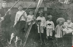
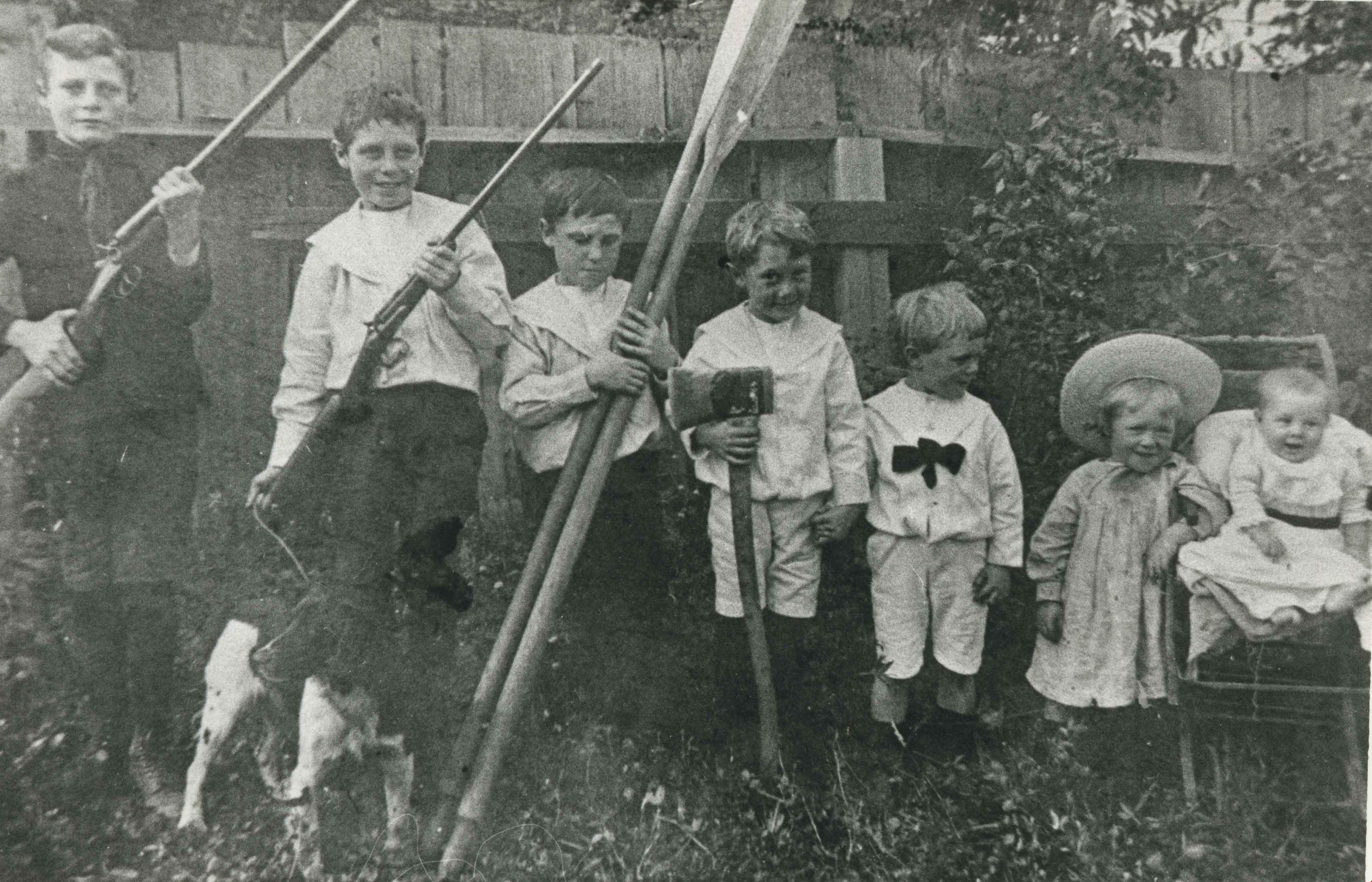
- Photograph of seven of the nine children of Ernest A. Yorston and Florence L. Yorston (nee Marston). Left to right: Eric Yorston, Cyril Yorston, Harry Yorston, Edward Yorston, Wilfred "Waff" Yorston, John "Jack" Yorston and Oswald "Obbie" Yorston. The older boys are holding shot guns, Harry is hol…
- Repository
- City of Burnaby Archives
- Date
- 1909
- Collection/Fonds
- Burnaby Historical Society fonds
- Subseries
- Pioneer Tales subseries
- Physical Description
- 1 photograph : b&w ; 12.7 x 17.8 cm print
- Description Level
- Item
- Record No.
- 204-338
- Access Restriction
- No restrictions
- Reproduction Restriction
- No restrictions
- Accession Number
- BHS1988-03
- Scope and Content
- Photograph of seven of the nine children of Ernest A. Yorston and Florence L. Yorston (nee Marston). Left to right: Eric Yorston, Cyril Yorston, Harry Yorston, Edward Yorston, Wilfred "Waff" Yorston, John "Jack" Yorston and Oswald "Obbie" Yorston. The older boys are holding shot guns, Harry is holding two paddles and Edward is holding an axe. This gag shot was taken by their father.
- Subjects
- Armament - Firearms
- Animals - Dogs
- Names
- Yorston, Cyril
- Yorston, Edward
- Yorston, Eric
- Yorston, Harry
- Yorston, John "Jack"
- Yorston, Oswald
- Yorston, Wilfred "Waff"
- Media Type
- Photograph
- Photographer
- Yorston, Ernest A.
- Notes
- Title based on contents of photograph
Images
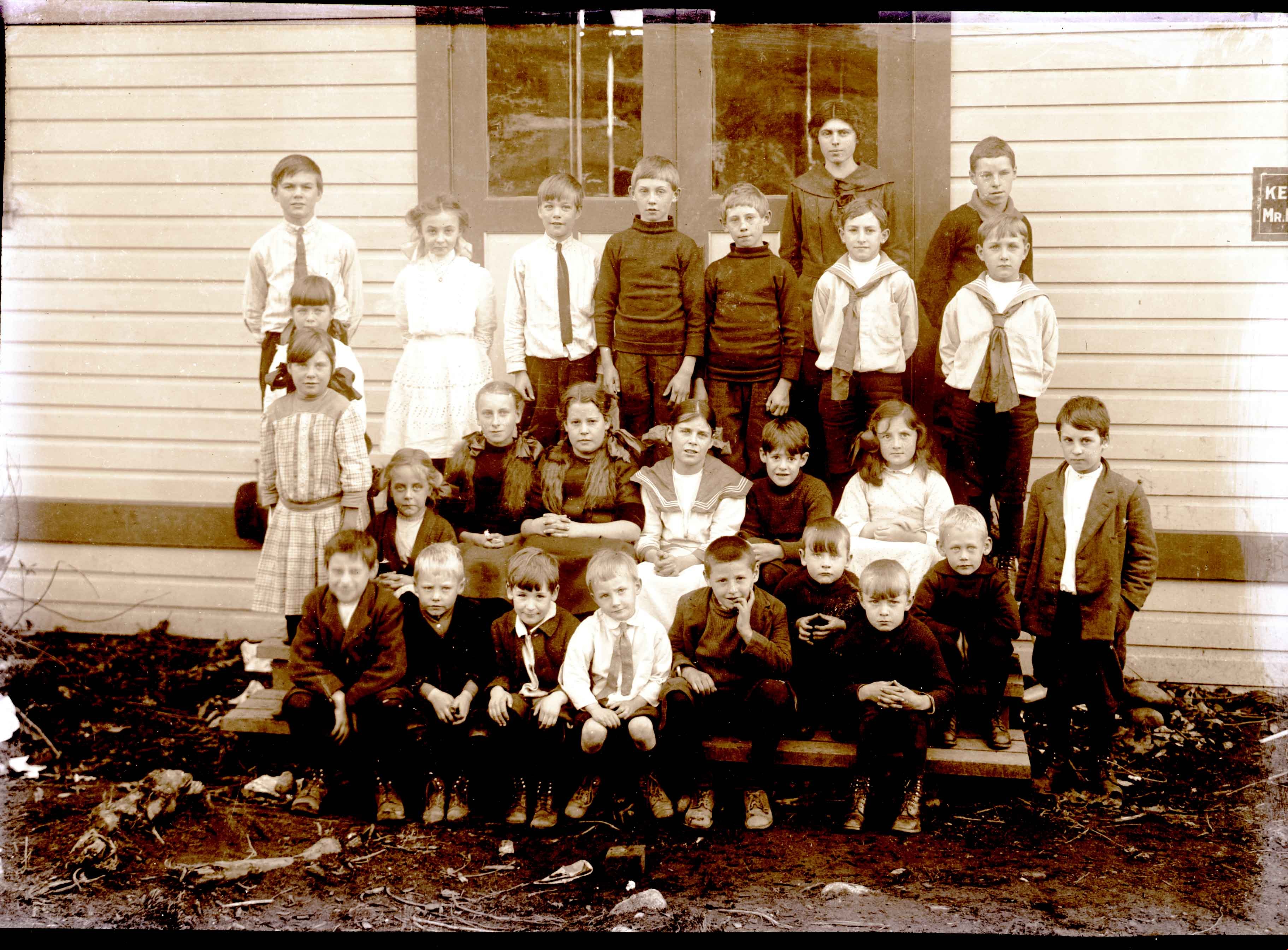
![Edmonds School class, [1909 or 1910] thumbnail](/media/hpo/_Data/_Archives_Images/_Unrestricted/205/207-018.jpg?width=280)
Edmonds School class
https://search.heritageburnaby.ca/link/archivedescription35969
- Repository
- City of Burnaby Archives
- Date
- [1909 or 1910]
- Collection/Fonds
- Burnaby Historical Society fonds
- Description Level
- Item
- Physical Description
- 1 photograph : b&w ; 7.5 x 10 cm print
- Scope and Content
- Photograph of an Edmonds Street School class lined up in rows outside of their classroom. All of the children have their arms folded in front of them, with the first two rows sitting cross-legged, and the last two rows standing on their feet.
- Repository
- City of Burnaby Archives
- Date
- [1909 or 1910]
- Collection/Fonds
- Burnaby Historical Society fonds
- Subseries
- Edmonds School subseries
- Physical Description
- 1 photograph : b&w ; 7.5 x 10 cm print
- Description Level
- Item
- Record No.
- 207-018
- Access Restriction
- No restrictions
- Reproduction Restriction
- No known restrictions
- Accession Number
- BHS1988-07
- Scope and Content
- Photograph of an Edmonds Street School class lined up in rows outside of their classroom. All of the children have their arms folded in front of them, with the first two rows sitting cross-legged, and the last two rows standing on their feet.
- Names
- Edmonds Community School
- Media Type
- Photograph
- Notes
- Title based on contents of photograph
- Geographic Access
- 18th Avenue
- Street Address
- 7651 18th Avenue
- Historic Neighbourhood
- Edmonds (Historic Neighbourhood)
- Planning Study Area
- Edmonds Area
Images
![Edmonds School class, [1909 or 1910] thumbnail](/media/hpo/_Data/_Archives_Images/_Unrestricted/205/207-018.jpg)

Jubilee Methodist Church
https://search.heritageburnaby.ca/link/archivedescription36018
- Repository
- City of Burnaby Archives
- Date
- 1909
- Collection/Fonds
- Burnaby Historical Society fonds
- Description Level
- Item
- Physical Description
- 1 photograph : sepia postcard ; 8 x 13 cm
- Scope and Content
- Photographic postcard of the Jubilee Methodist Church.
- Repository
- City of Burnaby Archives
- Date
- 1909
- Collection/Fonds
- Burnaby Historical Society fonds
- Subseries
- Ephemera subseries
- Physical Description
- 1 photograph : sepia postcard ; 8 x 13 cm
- Description Level
- Item
- Record No.
- 212-001
- Access Restriction
- No restrictions
- Reproduction Restriction
- No known restrictions
- Accession Number
- BHS1988-12
- Scope and Content
- Photographic postcard of the Jubilee Methodist Church.
- Media Type
- Photograph
- Notes
- Title based on contents of photograph
- Geographic Access
- Sussex Avenue
- Street Address
- 6050 Sussex Avenue
- Historic Neighbourhood
- Central Park (Historic Neighbourhood)
- Planning Study Area
- Marlborough Area
Images

B.G. Walker house
https://search.heritageburnaby.ca/link/archivedescription36021
- Repository
- City of Burnaby Archives
- Date
- 1909
- Collection/Fonds
- Burnaby Historical Society fonds
- Description Level
- Item
- Physical Description
- 1 photograph : sepia postcard ; 8 x 14 cm
- Scope and Content
- Photographic postcard of the B.G. Walker House, at Edmonds & Kingsway.
- Repository
- City of Burnaby Archives
- Date
- 1909
- Collection/Fonds
- Burnaby Historical Society fonds
- Subseries
- Patterson family subseries
- Physical Description
- 1 photograph : sepia postcard ; 8 x 14 cm
- Description Level
- Item
- Record No.
- 213-003
- Access Restriction
- No restrictions
- Reproduction Restriction
- No known restrictions
- Accession Number
- BHS1988-13
- Scope and Content
- Photographic postcard of the B.G. Walker House, at Edmonds & Kingsway.
- Subjects
- Buildings - Residential - Houses
- Media Type
- Photograph
- Notes
- Title based on contents of photograph
- Geographic Access
- Edmonds Street
- Street Address
- 7328 Edmonds Street
- Historic Neighbourhood
- Edmonds (Historic Neighbourhood)
- Planning Study Area
- Richmond Park Area
Images

![Pengelly's logging shack, [1909] thumbnail](/media/hpo/_Data/_Archives_Images/_Unrestricted/205/222-005.jpg?width=280)
Pengelly's logging shack
https://search.heritageburnaby.ca/link/archivedescription36082
- Repository
- City of Burnaby Archives
- Date
- [1909]
- Collection/Fonds
- Burnaby Historical Society fonds
- Description Level
- Item
- Physical Description
- 1 photograph : b&w ; 9 x 11.5 cm
- Scope and Content
- Photograph of Pengelly's logging shack, believed to be at Union Street and Duthie Avenue. One lumberjack is standing just outside the shack with an axe in his hand, while another is wiping his face with a cloth and a third is standing with one foot bracing a felled log with a saw in his hand.
- Repository
- City of Burnaby Archives
- Date
- [1909]
- Collection/Fonds
- Burnaby Historical Society fonds
- Subseries
- Columbian Newspaper subseries
- Physical Description
- 1 photograph : b&w ; 9 x 11.5 cm
- Description Level
- Item
- Record No.
- 222-005
- Access Restriction
- No restrictions
- Reproduction Restriction
- No known restrictions
- Accession Number
- BHS1989-19
- Scope and Content
- Photograph of Pengelly's logging shack, believed to be at Union Street and Duthie Avenue. One lumberjack is standing just outside the shack with an axe in his hand, while another is wiping his face with a cloth and a third is standing with one foot bracing a felled log with a saw in his hand.
- Media Type
- Photograph
- Notes
- Title based on contents of photograph
- 2 b&w copy negatives accompanying
- Geographic Access
- Duthie Avenue
- Union Street
- Historic Neighbourhood
- Lochdale (Historic Neighbourhood)
- Planning Study Area
- Lochdale Area
Images
![Pengelly's logging shack, [1909] thumbnail](/media/hpo/_Data/_Archives_Images/_Unrestricted/205/222-005.jpg)
![Johnson family at Stanley Park, [1909] thumbnail](/media/hpo/_Data/_Archives_Images/_Unrestricted/316/335-006.jpg?width=280)
Johnson family at Stanley Park
https://search.heritageburnaby.ca/link/archivedescription37203
- Repository
- City of Burnaby Archives
- Date
- [1909]
- Collection/Fonds
- Burnaby Historical Society fonds
- Description Level
- Item
- Physical Description
- 1 photograph : albumen ; 11.5 x 17 cm, mounted on board 19.5 x 24.5 cm
- Scope and Content
- Photograph of the Johnson family in a horse and carriage at the hollow tree in Stanley Park in Vancouver, BC.
- Repository
- City of Burnaby Archives
- Date
- [1909]
- Collection/Fonds
- Burnaby Historical Society fonds
- Subseries
- Andrew Johnson subseries
- Physical Description
- 1 photograph : albumen ; 11.5 x 17 cm, mounted on board 19.5 x 24.5 cm
- Description Level
- Item
- Record No.
- 335-006
- Access Restriction
- No restrictions
- Reproduction Restriction
- No known restrictions
- Accession Number
- BHS1997-16
- Scope and Content
- Photograph of the Johnson family in a horse and carriage at the hollow tree in Stanley Park in Vancouver, BC.
- Media Type
- Photograph
- Photographer
- Stanley Park Photographers
- Notes
- Title based on contents of photograph
- Photographer's stamp on verso of mount reads: "FROM/ The Stanley Park Photographers./ HEAD OFFICE. 61 Cordova Street,/ Vancouver, B.C./ When ordering duplicates of this photo, mention negative No. 6623"
- 1 b&w copy negative accompanying
Images
![Johnson family at Stanley Park, [1909] thumbnail](/media/hpo/_Data/_Archives_Images/_Unrestricted/316/335-006.jpg)
![Barnet Mill being rebuilt, [1909] (date of original), copied [1998] thumbnail](/media/hpo/_Data/_Archives_Images/_Unrestricted/316/363-002.jpg?width=280)
Barnet Mill being rebuilt
https://search.heritageburnaby.ca/link/archivedescription37363
- Repository
- City of Burnaby Archives
- Date
- [1909] (date of original), copied [1998]
- Collection/Fonds
- Burnaby Historical Society fonds
- Description Level
- Item
- Physical Description
- 1 photograph : b&w ; 10 x 15 cm print
- Scope and Content
- Photograph of lumber piled up and the skeleton of a building being framed during the rebuilding of the Barnet Mill after the fire of 1909. The Barnet Mill was called the North Pacific Lumber Company from 1889 to 1914.
- Repository
- City of Burnaby Archives
- Date
- [1909] (date of original), copied [1998]
- Collection/Fonds
- Burnaby Historical Society fonds
- Subseries
- Jim Wolf subseries
- Physical Description
- 1 photograph : b&w ; 10 x 15 cm print
- Description Level
- Item
- Record No.
- 363-002
- Access Restriction
- No restrictions
- Reproduction Restriction
- No known restrictions
- Accession Number
- BHS1998-13
- Scope and Content
- Photograph of lumber piled up and the skeleton of a building being framed during the rebuilding of the Barnet Mill after the fire of 1909. The Barnet Mill was called the North Pacific Lumber Company from 1889 to 1914.
- Names
- Barnet Mill
- Media Type
- Photograph
- Notes
- Title based on contents of photograph
- Geographic Access
- Barnet Village
- Texaco Drive
- Street Address
- 8059 Texaco Drive
- Historic Neighbourhood
- Barnet (Historic Neighbourhood)
- Planning Study Area
- Burnaby Mountain Area
Images
![Barnet Mill being rebuilt, [1909] (date of original), copied [1998] thumbnail](/media/hpo/_Data/_Archives_Images/_Unrestricted/316/363-002.jpg)
![Ship at Barnet Mill, [1910] (date of original), copied [1998] thumbnail](/media/hpo/_Data/_Archives_Images/_Unrestricted/316/363-003.jpg?width=280)
Ship at Barnet Mill
https://search.heritageburnaby.ca/link/archivedescription37364
- Repository
- City of Burnaby Archives
- Date
- [1910] (date of original), copied [1998]
- Collection/Fonds
- Burnaby Historical Society fonds
- Description Level
- Item
- Physical Description
- 1 photograph : b&w ; 10 x 15 cm print
- Scope and Content
- Photograph of a ship docked next to the mill at Barnet. The Barnet Mill was called the North Pacific Lumber Company from 1889 to 1914.
- Repository
- City of Burnaby Archives
- Date
- [1910] (date of original), copied [1998]
- Collection/Fonds
- Burnaby Historical Society fonds
- Subseries
- Jim Wolf subseries
- Physical Description
- 1 photograph : b&w ; 10 x 15 cm print
- Description Level
- Item
- Record No.
- 363-003
- Access Restriction
- No restrictions
- Reproduction Restriction
- No known restrictions
- Accession Number
- BHS1998-13
- Scope and Content
- Photograph of a ship docked next to the mill at Barnet. The Barnet Mill was called the North Pacific Lumber Company from 1889 to 1914.
- Subjects
- Transportation - Ships
- Names
- Barnet Mill
- Media Type
- Photograph
- Notes
- Title based on contents of photograph
- Geographic Access
- Barnet Village
- Texaco Drive
- Street Address
- 8059 Texaco Drive
- Historic Neighbourhood
- Barnet (Historic Neighbourhood)
- Planning Study Area
- Burnaby Mountain Area
Images
![Ship at Barnet Mill, [1910] (date of original), copied [1998] thumbnail](/media/hpo/_Data/_Archives_Images/_Unrestricted/316/363-003.jpg)

Edward W. Nicholson and Team of Horses Inside Tree Stump
https://search.heritageburnaby.ca/link/archivedescription38266
- Repository
- City of Burnaby Archives
- Date
- 1909
- Collection/Fonds
- Burnaby Historical Society fonds
- Description Level
- Item
- Physical Description
- 1 photograph : sepia ; 11 x 16.5 cm on 17.8 x 22.5 cm backing
- Scope and Content
- Photograph of Edward Nicholson standing with a team of horses inside the hollowed stump of a tree. Five other men and a dog are seated on planks on top of the stump and another man and two women are sitting to the left on the exposed roots of the tree. The man on seated to the right is identified …
- Repository
- City of Burnaby Archives
- Date
- 1909
- Collection/Fonds
- Burnaby Historical Society fonds
- Subseries
- Margaret McCallum subseries
- Physical Description
- 1 photograph : sepia ; 11 x 16.5 cm on 17.8 x 22.5 cm backing
- Description Level
- Item
- Record No.
- 375-028
- Access Restriction
- No restrictions
- Reproduction Restriction
- No known restrictions
- Accession Number
- BHS1986-42
- Scope and Content
- Photograph of Edward Nicholson standing with a team of horses inside the hollowed stump of a tree. Five other men and a dog are seated on planks on top of the stump and another man and two women are sitting to the left on the exposed roots of the tree. The man on seated to the right is identified as Duncan MacInnes.
- Subjects
- Transportation - Horses
- Plants - Trees
- Media Type
- Photograph
- Notes
- Title based on caption
- A note on the back of the photograph reads: "E.W. Nicholson first resident of Broadview District of Burnaby - 1900 May 23rd. Picture taken 1909. Edward W. Nicholson, with team of horses inside stump (Cedar). Stump 36 feet in diameter. Duncan MacInnes sitting extreme right. Horses were turned around inside stump."
- Geographic Access
- Boundary Road
- Street Address
- 2550 Boundary Road
- Historic Neighbourhood
- Broadview (Historic Neighbourhood)
- Planning Study Area
- West Central Valley Area
Images

Teacher with her class
https://search.heritageburnaby.ca/link/archivedescription38277
- Repository
- City of Burnaby Archives
- Date
- 1909
- Collection/Fonds
- Burnaby Historical Society fonds
- Description Level
- Item
- Physical Description
- 1 photograph : sepia postcard ; 8.6 x 13.8 cm
- Scope and Content
- Photographic postcard of a teacher with a class of twenty-eight students, standing on the steps of an unknown school. All in the photograph are unidentified. The postcard has been used and is addressed to a "Miss Alice Holland, Timberland, Yale Road" and is postmaked "Vancouver, May 22, 1909." The …
- Repository
- City of Burnaby Archives
- Date
- 1909
- Collection/Fonds
- Burnaby Historical Society fonds
- Subseries
- Photographs subseries
- Physical Description
- 1 photograph : sepia postcard ; 8.6 x 13.8 cm
- Description Level
- Item
- Record No.
- 383-001
- Access Restriction
- No restrictions
- Reproduction Restriction
- No known restrictions
- Accession Number
- BHS2007-04
- Scope and Content
- Photographic postcard of a teacher with a class of twenty-eight students, standing on the steps of an unknown school. All in the photograph are unidentified. The postcard has been used and is addressed to a "Miss Alice Holland, Timberland, Yale Road" and is postmaked "Vancouver, May 22, 1909." The note written on the postcard reads: "Dear Alice, You will be surprised to get this card but I hope you will like it. Your papa will show you which is me. This is my room at the school. Do you go to school yet? Your papa will see on the card who took these. The little girl where the cross is, is the one that saved me from drowning last summer. I am partial to her. Come and see me soon. From your friend, Olive."
- Names
- Holland, Alice
- Media Type
- Photograph
- Photographer
- Brown, W.
- Notes
- Title based on contents of photograph
Images


Mills Burning at Barnet
https://search.heritageburnaby.ca/link/archivedescription38342
- Repository
- City of Burnaby Archives
- Date
- May 6, 1909
- Collection/Fonds
- Burnaby Historical Society fonds
- Description Level
- Item
- Physical Description
- 1 photograph : sepia postcard ; 8 x 13.4 cm
- Scope and Content
- Photographic postcard of the line of buildings burning at the North Pacific Lumber Company, with flames and smoke visible rising from the structures. A caption stamped at the top of the postcard reads: "Mills burning at Barnet BC. 1:30a.m. May 6th, 1909."
- Repository
- City of Burnaby Archives
- Date
- May 6, 1909
- Collection/Fonds
- Burnaby Historical Society fonds
- Subseries
- Charles Lee subseries
- Physical Description
- 1 photograph : sepia postcard ; 8 x 13.4 cm
- Description Level
- Item
- Record No.
- 411-001
- Access Restriction
- No restrictions
- Reproduction Restriction
- No known restrictions
- Accession Number
- BHS2000-13
- Scope and Content
- Photographic postcard of the line of buildings burning at the North Pacific Lumber Company, with flames and smoke visible rising from the structures. A caption stamped at the top of the postcard reads: "Mills burning at Barnet BC. 1:30a.m. May 6th, 1909."
- Names
- Barnet Mill
- Media Type
- Photograph
- Geographic Access
- Barnet Village
- Texaco Drive
- Street Address
- 8059 Texaco Drive
- Historic Neighbourhood
- Barnet (Historic Neighbourhood)
- Planning Study Area
- Burnaby Mountain Area
Images

![Charles Boyer Brown, by photographer Nicholas Rossmo [1950]. Item no. 307-008 thumbnail](/media/hpo/_Data/_Archives_Images/_Unrestricted/251/307-008.jpg?width=280)
Interview with Charles B. Brown May 21, 1975 - Track 1
https://search.heritageburnaby.ca/link/oralhistory27
- Repository
- City of Burnaby Archives
- Date Range
- 1909-1938
- Length
- 00:07:15
- Summary
- This portion of the interview pertains to Charles Boyer Brown's early days working at Burnaby's Municipal Hall, first as an office boy.
- Repository
- City of Burnaby Archives
- Summary
- This portion of the interview pertains to Charles Boyer Brown's early days working at Burnaby's Municipal Hall, first as an office boy.
- Date Range
- 1909-1938
- Photo Info
- Charles Boyer Brown, by photographer Nicholas Rossmo [1950]. Item no. 307-008
- Length
- 00:07:15
- Subjects
- Occupations - Civic Workers
- Interviewer
- Bradbury, Dr. Bettina
- Interview Date
- May 21, 1975
- Scope and Content
- Recording is a taped interview with Charles B. Brown by SFU (Simon Fraser University) graduate student Bettina Bradbury May 21, 1975. Major themes discussed are: the Depression, the Commissioner and municipal politics in general. To view "Narrow By" terms for each track expand this description and see "Notes".
- Biographical Notes
- Charles Boyer Brown was born on June 16, 1894 in the town of Ongar, Essex, England. He came to Canada as a young child with his parents Jean and Percy Brown. In 1903, the family settled in New Westminster and by 1911, Charles had joined the Burnaby municipal staff working as an office boy. The outbreak of World War One interrupted Charlie’s career as he immediately enlisted with the Royal Engineers and served from 1915 to 1918. While overseas he met and married Lillian Bernice Bryan and they returned to Canada together after the war and Charles resumed his position in municipal administration. For a short time, Charles was appointed as the Municipal Assessor, but in 1927 he became the Assistant Municipal Clerk. In 1933, Charles was made Municipal Clerk, a post he held until he retired in 1959. Charles has also been credited with playing a significant role in administering the city while it was under the rule of the provincial commission from 1932-1942. Recognized for his expertise in civic affairs, Charles was appointed by the provincial government to a committee formed to review and revise the Municipal Act. He was also a member of the BC Municipal Officers’ Association from its formation in 1936 and was made its chair in 1953. While these civic duties occupied much of his time, Charles still managed to participate as a volunteer on many sport and youth clubs in the city and served as the secretary for the Kingsway Rotary Club. In recognition of his outstanding contributions to Burnaby, both paid and volunteer, Charles was presented with the Gold Key award in 1959, the same year he finally retired from municipal administration. During Charles’ lifetime, many changes took place in the Municipality that he loved. He saw Burnaby grow in population and progress and he could be proud of the significant part he played in that growth and development. Charles Brown died on August 11, 1981.
- Total Tracks
- 8
- Total Length
- 0:58:01
- Interviewee Name
- Brown, Charles B. "Charlie"
- Interview Location
- Walker Avenue
- Interviewer Bio
- Bettina Bradbury teaches history and women's studies at York University. She is the author of Wife to Widow. Lives, Laws and Politics in Nineteenth-century Montreal. (Vancouver: University of British Columbia Press, June 2011), 520p; Working Families. Age, Gender and Daily Survival in Industrializing Montreal. (Toronto: Canadian Social History Series, McClelland and Stewart, 1993); (Republished Toronto: Oxford University Press, 1996) (3rd edition, Toronto: University of Toronto Press, 2007). These interviews were undertaken after she completed her MA at Simon Fraser University in 1975 with the support of an LIP grant.
- Collection/Fonds
- Burnaby Historical Society fonds
- Subseries
- Oral history subseries
- Transcript Available
- None
- Media Type
- Sound Recording
- Web Notes
- Interview was digitized in 2010 allowing it to be accessible on Heritage Burnaby. The digitization project was initiated by the Community Heritage Commission with support from City of Burnaby Council and the BC History Digitization Program of the Irving K. Barber Learning Centre, University of British Columbia. It was recognized by the Heritage Society of BC with an award in 2012.
Images
![Charles Boyer Brown, by photographer Nicholas Rossmo [1950]. Item no. 307-008 thumbnail](/media/hpo/_Data/_Archives_Images/_Unrestricted/251/307-008.jpg)
Audio Tracks
Track one of interview with Charles B. Brown
Track one of interview with Charles B. Brown
https://search.heritageburnaby.ca/media/hpo/_Data/_Archives_Oral_Histories/_Unrestricted/100-13-06/100-13-06_Track_1.mp3
Maude Holmstrom interview April 1989 - Track 1
https://search.heritageburnaby.ca/link/oralhistory263
- Repository
- City of Burnaby Archives
- Date Range
- 1909-1914
- Length
- 0:07:09
- Summary
- This portion of the recording includes (Lucy) Maude (Goodridge) Holmstrom's memories of first coming to Burnaby with her family, especially her mother and father, and the establishment of the Goodridge's grocery store.
- Repository
- City of Burnaby Archives
- Summary
- This portion of the recording includes (Lucy) Maude (Goodridge) Holmstrom's memories of first coming to Burnaby with her family, especially her mother and father, and the establishment of the Goodridge's grocery store.
- Date Range
- 1909-1914
- Photo Info
- Maude Goodridge Holmstrom (middle row, 4th from right) with her Howard Avenue class, photographed by J.W. Phillips, 1913. Item no. 487-004
- Length
- 0:07:09
- Historic Neighbourhood
- Capitol Hill (Historic Neighbourhood)
- Interviewer
- Johnson, Lou
- Interview Date
- April 1989
- Scope and Content
- Recording is of an interview with (Lucy) Maude (Goodridge) Holmstrom, conducted by her grandniece, Lou Johnson, April 1989. Major themes discussed are: Capitol Hill, early pioneers in Burnaby, Howard Avenue School.
- Biographical Notes
- Lucy Maude "Maude" Goodrige was born on Aprril 13, 1902 at Stanley Place, London, England. She was the eldest child of John Charles Bertram and Lucy (Elston) Goodridge, with four siblings; Alice Victoria, Gwendoline Elston "Gwen", Beatrice Alexandra, and George Edward Goodridge. John and Lucy Goodridge moved their family from Victoria Drive to Burnaby into a one room house on Capitol Hill, built over one year by John himself. At first, the family had to walk to Rosser to get drinking water, wheeling wheelbarrows full of water back home. Later on, John would discover a Grotto of fresh water on their property. When surveyors started showing land, travelling on horseback from Boundary Road to Capitol Hill, Lucy (Elston) Goodridge would offer lemonade and oranges to the thirsty settlers. This gave her the idea to start the first grocery store in the area, at Alpha and Hastings. Kelly Douglas helped the Goodridges stock the store with larger food orders. For smaller quantities, they used Swift and Company downtown. Maude first went to Howard Avenue School with her younger siblings then to the four room school Gilmore Avenue when it opened. Before John Goodridge went off to war in 1914, he handled grocery delivery and restocking using a team of horses. No one else in the family could handle the team, so while he was overseas, Maude would travel down to Swift and Company by streetcar and be forced to wait for a ride home from someone passing by as the stock was too heavy to carry on foot. Later, Maude remembers a Ford dealer coming to teach her how to drive, in effort to get her mother to buy a Ford. It worked. Maude lived at Capitol Hill until 1920. At the time of the depression, she was in California with her first husband, John Joseph Lemire whom she married October 14, 1922 in Vancouver. Gwendoline Elston "Gwen" Goodridge married William Lister of Point Grey, June 27, 1928. Alice Victoria Goodridge married David Augustus Norman September 24, 1929. Lucy Maude "Maude" (Goodridge) later married George William Holmstrom. George William Holmstrom died in 1957. His wife, Lucy Maude "Maude" (Goodridge) Holmstrom died in 1994.
- Total Tracks
- 3
- Total Length
- 0:23:44
- Interviewee Name
- Holmstrom, Lucy Maude "Maude" Goodridge Lemire
- Collection/Fonds
- Burnaby Historical Society fonds
- Subseries
- Oral history subseries
- Media Type
- Sound Recording
- Web Notes
- Interview was digitized in 2010 allowing it to be accessible on Heritage Burnaby. The digitization project was initiated by the Community Heritage Commission with support from City of Burnaby Council and the BC History Digitization Program of the Irving K. Barber Learning Centre, University of British Columbia. It was recognized by the Heritage Society of BC with an award in 2012.
Images
Audio Tracks
Track one of recording of interview with Maude Holmstrom
Track one of recording of interview with Maude Holmstrom
https://search.heritageburnaby.ca/media/hpo/_Data/_Archives_Oral_Histories/_Unrestricted/MSS137-007/MSS137-007_Track_1.mp3
Maude Holmstrom interview April 1989 - Track 3
https://search.heritageburnaby.ca/link/oralhistory265
- Repository
- City of Burnaby Archives
- Date Range
- 1909-1929
- Length
- 0:06:51
- Summary
- This portion of the recording includes (Lucy) Maude (Goodridge) Holmstrom's memories of her family life during the early days of Burnaby.
- Repository
- City of Burnaby Archives
- Summary
- This portion of the recording includes (Lucy) Maude (Goodridge) Holmstrom's memories of her family life during the early days of Burnaby.
- Date Range
- 1909-1929
- Photo Info
- Maude Goodridge Holmstrom (middle row, 4th from right) with her Howard Avenue class, photographed by J.W. Phillips, 1913. Item no. 487-004
- Length
- 0:06:51
- Historic Neighbourhood
- Capitol Hill (Historic Neighbourhood)
- Interviewer
- Johnson, Lou
- Interview Date
- April 1989
- Scope and Content
- Recording is of an interview with (Lucy) Maude (Goodridge) Holmstrom, conducted by her grandniece, Lou Johnson, April 1989. Major themes discussed are: Capitol Hill, early pioneers in Burnaby, Howard Avenue School.
- Biographical Notes
- Lucy Maude "Maude" Goodrige was born on Aprril 13, 1902 at Stanley Place, London, England. She was the eldest child of John Charles Bertram and Lucy (Elston) Goodridge, with four siblings; Alice Victoria, Gwendoline Elston "Gwen", Beatrice Alexandra, and George Edward Goodridge. John and Lucy Goodridge moved their family from Victoria Drive to Burnaby into a one room house on Capitol Hill, built over one year by John himself. At first, the family had to walk to Rosser to get drinking water, wheeling wheelbarrows full of water back home. Later on, John would discover a Grotto of fresh water on their property. When surveyors started showing land, travelling on horseback from Boundary Road to Capitol Hill, Lucy (Elston) Goodridge would offer lemonade and oranges to the thirsty settlers. This gave her the idea to start the first grocery store in the area, at Alpha and Hastings. Kelly Douglas helped the Goodridges stock the store with larger food orders. For smaller quantities, they used Swift and Company downtown. Maude first went to Howard Avenue School with her younger siblings then to the four room school Gilmore Avenue when it opened. Before John Goodridge went off to war in 1914, he handled grocery delivery and restocking using a team of horses. No one else in the family could handle the team, so while he was overseas, Maude would travel down to Swift and Company by streetcar and be forced to wait for a ride home from someone passing by as the stock was too heavy to carry on foot. Later, Maude remembers a Ford dealer coming to teach her how to drive, in effort to get her mother to buy a Ford. It worked. Maude lived at Capitol Hill until 1920. At the time of the depression, she was in California with her first husband, John Joseph Lemire whom she married October 14, 1922 in Vancouver. Gwendoline Elston "Gwen" Goodridge married William Lister of Point Grey, June 27, 1928. Alice Victoria Goodridge married David Augustus Norman September 24, 1929. Lucy Maude "Maude" (Goodridge) later married George William Holmstrom. George William Holmstrom died in 1957. His wife, Lucy Maude "Maude" (Goodridge) Holmstrom died in 1994.
- Total Tracks
- 3
- Total Length
- 0:23:44
- Interviewee Name
- Holmstrom, Lucy Maude "Maude" Goodridge Lemire
- Collection/Fonds
- Burnaby Historical Society fonds
- Subseries
- Oral history subseries
- Media Type
- Sound Recording
- Web Notes
- Interview was digitized in 2010 allowing it to be accessible on Heritage Burnaby. The digitization project was initiated by the Community Heritage Commission with support from City of Burnaby Council and the BC History Digitization Program of the Irving K. Barber Learning Centre, University of British Columbia. It was recognized by the Heritage Society of BC with an award in 2012.
Images
Audio Tracks
Track three of recording of interview with Maude Holmstrom
Track three of recording of interview with Maude Holmstrom
https://search.heritageburnaby.ca/media/hpo/_Data/_Archives_Oral_Histories/_Unrestricted/MSS137-007/MSS137-007_Track_3.mp3
H.T. Ceperley Estate 'Fairacres' Root House
https://search.heritageburnaby.ca/link/landmark527
- Repository
- Burnaby Heritage Planning
- Description
- The ‘Fairacres’ Root House is a long, low one-storey masonry building, measuring 4.6 metres by 9.1 metres, with massively buttressed concrete walls and foundations. Built into sloping ground adjacent to the location of the former greenhouses, the surviving orchard and the kitchen entrance of the ma…
- Associated Dates
- 1908
- Formal Recognition
- Heritage Designation, Community Heritage Register
- Repository
- Burnaby Heritage Planning
- Geographic Access
- Deer Lake Avenue
- Associated Dates
- 1908
- Formal Recognition
- Heritage Designation, Community Heritage Register
- Enactment Type
- Bylaw No. 9807
- Enactment Date
- 23/11/1992
- Description
- The ‘Fairacres’ Root House is a long, low one-storey masonry building, measuring 4.6 metres by 9.1 metres, with massively buttressed concrete walls and foundations. Built into sloping ground adjacent to the location of the former greenhouses, the surviving orchard and the kitchen entrance of the main house, 'Fairacres,' this functional structure was used as a frost-free store for fruit and vegetables for the family's use.
- Heritage Value
- The outbuildings at 'Fairacres' are a rare surviving architecturally-designed ensemble of agricultural structures that exist in complementary harmony with the main estate house. Architect Robert Mackay Fripp (1858-1917), an outspoken advocate of Arts and Crafts design, was retained by the Ceperleys to design several original outbuildings on their estate. The Root House is important as a rare surviving, and exceptionally large, example of this building type in the Vancouver region. Unusual in the fact that an architect designed a building of such modest aspirations, it is also remarkable in its method of construction. The use of concrete as a structural material is one of the earliest in the region and extraordinary for its use on such a modest vernacular outbuilding; root cellars were typically built of loose stone. Built in 1908, the Root House was significantly altered in the 1960s and restored to its original design in 2000. The building is significant as an indicator of the market gardening activity in the area around Deer Lake and of the country-house self-sufficiency practiced by the Ceperley family. The Root House illustrates the cultural, aesthetic, and lifestyle values of the Ceperleys in constructing such a large building for storing their own produce.
- Defining Elements
- The outbuildings at 'Fairacres' are a rare surviving architecturally-designed ensemble of agricultural structures that exist in complementary harmony with the main estate house. Architect Robert Mackay Fripp (1858-1917), an outspoken advocate of Arts and Crafts design, was retained by the Ceperleys to design several original outbuildings on their estate. The Root House is important as a rare surviving, and exceptionally large, example of this building type in the Vancouver region. Unusual in the fact that an architect designed a building of such modest aspirations, it is also remarkable in its method of construction. The use of concrete as a structural material is one of the earliest in the region and extraordinary for its use on such a modest vernacular outbuilding; root cellars were typically built of loose stone. Built in 1908, the Root House was significantly altered in the 1960s and restored to its original design in 2000. The building is significant as an indicator of the market gardening activity in the area around Deer Lake and of the country-house self-sufficiency practiced by the Ceperley family. The Root House illustrates the cultural, aesthetic, and lifestyle values of the Ceperleys in constructing such a large building for storing their own produce.
- Locality
- Deer Lake Park
- Historic Neighbourhood
- Burnaby Lake (Historic Neighbourhood)
- Planning Study Area
- Douglas-Gilpin Area
- Architect
- Robert Mackay Fripp
- Function
- Primary Historic--Outbuilding
- Secondary Historic--Food Storage
- Community
- Burnaby
- Cadastral Identifier
- P.I.D. No. 004-493-311 Legal Description: Block 3 Except: Part subdivided by Plan 26865, District Lot 79, Group 1, New Westminster District, Plan 536
- Boundaries
- ‘Fairacres’ is comprised of a single municipally-owned property located at 6344 Deer Lake Avenue, Burnaby.
- Area
- 17,065.00
- Contributing Resource
- Building
- Landscape Feature
- Ownership
- Public (local)
- Other Collection
- Burnaby Historical Society, Community Archives: Ceperley Photograph Album
- Documentation
- Heritage Site Files: PC77000 20. City of Burnaby Planning and Building Department, 4949 Canada Way, Burnaby, B.C., V5G 1M2
- Street Address
- 6344 Deer Lake Avenue
Images


H.T. Ceperley Estate 'Fairacres' Steam Plant Building
https://search.heritageburnaby.ca/link/landmark528
- Repository
- Burnaby Heritage Planning
- Description
- Designed in the British Arts and Crafts style, the ‘Fairacres’ Steam Plant Buiding is a single-storey wood frame building with a gabled roof that originally housed the apparatus for climate control in the greenhouses, formerly located to its north. The original rubble stone walls that formed the fo…
- Associated Dates
- 1908
- Formal Recognition
- Heritage Designation, Community Heritage Register
- Repository
- Burnaby Heritage Planning
- Geographic Access
- Deer Lake Avenue
- Associated Dates
- 1908
- Formal Recognition
- Heritage Designation, Community Heritage Register
- Enactment Type
- Bylaw No. 9807
- Enactment Date
- 23/11/1992
- Description
- Designed in the British Arts and Crafts style, the ‘Fairacres’ Steam Plant Buiding is a single-storey wood frame building with a gabled roof that originally housed the apparatus for climate control in the greenhouses, formerly located to its north. The original rubble stone walls that formed the foundation for the greenhouses stand adjacent. The Steam Plant Building stands as a pendant to the Root House, which is to the north of the former greenhouses.
- Heritage Value
- The outbuildings at 'Fairacres' are a rare surviving architecturally-designed ensemble of agricultural structures that exist in complementary harmony with the main estate house. Architect Robert Mackay Fripp (1858-1917), an outspoken advocate of Arts and Crafts design, was retained by the Ceperleys to design several original outbuildings on their estate. The Ceperleys operated 'Fairacres' with staff, a farm manager and workers, including Chinese, to grow produce for themselves and for sale at local markets. The Steam Plant Building illustrates the market gardening activity of the area around Deer Lake and its importance to the Ceperley family, which valued a year-round supply of fresh fruit and vegetables for the kitchen and flowers for the house. It also illustrates the cultural and aesthetic values of the Ceperleys in retaining an architect to design a functional outbuilding using an accepted and contemporary architectural style. Built in 1908, the Steam Plant Building was significantly altered in the 1960s and restored to its original design in 2000.
- Defining Elements
- Key elements that define the heritage character of the ‘Fairacres’ Steam Plant Building include its: - overall spatial arrangement of the Steam Plant Building in relation to the former greenhouses and the Root House - side gable roof with cedar shingle cladding. - tall brick chimney indicitive of the building's original function. - distinctive Arts and Crafts architectural features such as the shingle wall cladding with decorative shingling under window sills, deep eaves, and pebble-dashed concrete foundation walls - six-paned wooden-sash casement windows - simple functional interior features - rubble stone walls that formed the foundation for the greenhouses
- Locality
- Deer Lake Park
- Historic Neighbourhood
- Burnaby Lake (Historic Neighbourhood)
- Planning Study Area
- Douglas-Gilpin Area
- Architect
- Robert Mackay Fripp
- Function
- Primary Historic--Outbuilding
- Community
- Burnaby
- Cadastral Identifier
- P.I.D. No. 004-493-311 Legal Description: Block 3 Except: Part subdivided by Plan 26865, District Lot 79, Group 1, New Westminster District, Plan 536
- Boundaries
- ‘Fairacres’ is comprised of a single municipally-owned property located at 6344 Deer Lake Avenue, Burnaby.
- Area
- 17,065.00
- Contributing Resource
- Building
- Landscape Feature
- Ownership
- Public (local)
- Other Collection
- Burnaby Historical Society, Community Archives: Ceperley Photograph Album
- Documentation
- Heritage Site Files: PC77000 20. City of Burnaby Planning and Building Department, 4949 Canada Way, Burnaby, B.C., V5G 1M2
- Street Address
- 6344 Deer Lake Avenue
Images


H.T. Ceperley Estate 'Fairacres' Greenhouse Foundation Wall
https://search.heritageburnaby.ca/link/landmark862
- Repository
- Burnaby Heritage Planning
- Description
- The original rubble stone walls that formed the foundation for a greenhouses adjacent to the Steam Plant Building provided heat to several greenhouses on the estate propoerty. The Root House, which is to the north of the Greenhouse Foundation Wall, provided storage for the farm operation.
- Associated Dates
- 1908
- Formal Recognition
- Heritage Designation, Community Heritage Register
- Repository
- Burnaby Heritage Planning
- Geographic Access
- Deer Lake Avenue
- Associated Dates
- 1908
- Formal Recognition
- Heritage Designation, Community Heritage Register
- Enactment Type
- Bylaw No. 140665
- Enactment Date
- 23/11/1992
- Description
- The original rubble stone walls that formed the foundation for a greenhouses adjacent to the Steam Plant Building provided heat to several greenhouses on the estate propoerty. The Root House, which is to the north of the Greenhouse Foundation Wall, provided storage for the farm operation.
- Heritage Value
- The outbuildings at 'Fairacres' are a rare surviving architecturally-designed ensemble of agricultural structures that exist in complementary harmony with the main estate house. Architect Robert Mackay Fripp (1858-1917), an outspoken advocate of Arts and Crafts design, was retained by the Ceperleys to design several original outbuildings on their estate, which was designed as a country estate with a working farm that included over 10 acres of productive berry and vegetable fields, with a large kitchen garden, a root house to store food, an orchard, and greenhouses heated by steam. The agricultural potential of the Deer Lake area made it one of the first parts of the municipality to attract settlement. In 1909, the Ceperleys built three large greenhouses heated by an adjacent steam plant (Fairacres Steam Plant). The greenhouses featured granite foundation walls, including this one which remains intact. The Ceperleys employed a large staff to manage the estate's agricultural production, including Chinese farm labourers. Produce was grown for use at the estate, and for sale at local markets. Agricultural use of the estate continued when a Catholic order of Benedictine monks purchased the estate as part of the Priory of St. Joseph and the Seminary of Christ the King, and continued to farm the land until 1953.
- Defining Elements
- Key elements that define the heritage character of the ‘Fairacres’ Steam Plant Building include its: - overall spatial arrangement of the Greenhouse Foundation Wall in relation to the Steam Plant Building and the Root House - original rubble stone walls reflecting the Arts and Crafts design aesthetic of the estate buildings.
- Locality
- Deer Lake Park
- Historic Neighbourhood
- Burnaby Lake (Historic Neighbourhood)
- Planning Study Area
- Douglas-Gilpin Area
- Architect
- Robert Mackay Fripp
- Function
- Primary Historic--Outbuilding
- Community
- Burnaby
- Cadastral Identifier
- P.I.D. No. 004-493-311 Legal Description: Block 3 Except: Part subdivided by Plan 26865, District Lot 79, Group 1, New Westminster District, Plan 536
- Boundaries
- ‘Fairacres’ is comprised of a single municipally-owned property located at 6344 Deer Lake Avenue, Burnaby.
- Area
- 17,065.00
- Contributing Resource
- Landscape Feature
- Remains
- Ownership
- Public (local)
- Other Collection
- Burnaby Historical Society, Community Archives: Ceperley Photograph Album
- Documentation
- Heritage Site Files: PC77000 20. City of Burnaby Planning and Building Department, 4949 Canada Way, Burnaby, B.C., V5G 1M2
- Street Address
- 6344 Deer Lake Avenue
Images

