Narrow Results By

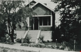
Isak & Lilly Gronning Residence
https://search.heritageburnaby.ca/link/landmark598
- Repository
- Burnaby Heritage Planning
- Description
- Residential building.
- Associated Dates
- c.1938
- Street View URL
- Google Maps Street View
- Repository
- Burnaby Heritage Planning
- Geographic Access
- Eton Street
- Associated Dates
- c.1938
- Description
- Residential building.
- Heritage Value
- This house was built for Isac Hartvig Peterson “Harry” Gronning (1880-1955), a Norwegian-born butcher, and his wife Lilly Geneva (née Hatton, 1889-1978). The Gronnings married in Vancouver in 1913, and lived in this home until at least Harry’s death in 1955. Designed to simulate a Norman-style cottage, the most distinctive feature of this eclectic bungalow is its round entry tower with a conical roof. Other distinctive features include its rolled roof edges that simulate a thatched roof, and its rounded arch windows surrounded with imitation voussoirs. It retains its original wooden-sash windows with leaded panes.
- Locality
- Vancouver Heights
- Historic Neighbourhood
- Vancouver Heights (Historic Neighbourhood)
- Planning Study Area
- Burnaby Heights Area
- Area
- 566.71
- Contributing Resource
- Building
- Ownership
- Private
- Street Address
- 3766 Eton Street
- Street View URL
- Google Maps Street View
Images


Vancouver Heights Presbyterian Church
https://search.heritageburnaby.ca/link/landmark649
- Repository
- Burnaby Heritage Planning
- Description
- Church building.
- Associated Dates
- 1930
- Street View URL
- Google Maps Street View
- Repository
- Burnaby Heritage Planning
- Geographic Access
- Esmond Avenue
- Associated Dates
- 1930
- Description
- Church building.
- Heritage Value
- This church replaced the first Vancouver Heights Presbyterian Church, which opened in 1911 and later became the Masonic Hall. This site was purchased in 1928, but the new church was not completed until 1930, due to the financial constraints of the Depression era. B.C. Lieutenant-Governor Bruce dedicated the church on Feb. 16, 1931. The building has retained its Classical Revival form and detailing, including its symmetrical design, columns flanking the recessed main entrance and arched windows with keystone detailing. The Vancouver Heights Presbyterian Church was designed by Australian-born architect H.H. Simmonds (1883-1954). After serving in the First World War, Simmonds resumed his local practice, and even during the Depression, his output remained prolific. In the 1920s and 30s, Simmonds was commissioned by the City of Vancouver to replace several pavilions at the Pacific National Exhibition with a consistent grouping of Art Deco buildings including the surviving Livestock Building (1929), Women and Fine Arts Building (1931) and Forum (1933).
- Locality
- Vancouver Heights
- Historic Neighbourhood
- Vancouver Heights (Historic Neighbourhood)
- Planning Study Area
- Burnaby Heights Area
- Architect
- H.H. Simmonds
- Area
- 566.79
- Contributing Resource
- Building
- Ownership
- Private
- Street Address
- 140 Esmond Avenue
- Street View URL
- Google Maps Street View
Images


![300 block of Esmonds, [between 1965 and 1970] thumbnail](/media/hpo/_Data/_Archives_Images/_Unrestricted/316/366-017.jpg?width=280)
300 block of Esmonds
https://search.heritageburnaby.ca/link/archivedescription37388
- Repository
- City of Burnaby Archives
- Date
- [between 1965 and 1970]
- Collection/Fonds
- Burnaby Historical Society fonds
- Description Level
- Item
- Physical Description
- 1 photograph : b&w negative
- Scope and Content
- Photograph taken looking south along the 300 block of Esmonds Avenue.
- Repository
- City of Burnaby Archives
- Date
- [between 1965 and 1970]
- Collection/Fonds
- Burnaby Historical Society fonds
- Subseries
- Municipal record subseries
- Physical Description
- 1 photograph : b&w negative
- Description Level
- Item
- Record No.
- 366-017
- Access Restriction
- No restrictions
- Reproduction Restriction
- Reproduce for fair dealing purposes only
- Accession Number
- BHS1998-12
- Scope and Content
- Photograph taken looking south along the 300 block of Esmonds Avenue.
- Subjects
- Geographic Features - Roads
- Media Type
- Photograph
- Notes
- Title based on contents of photograph
- Geographic Access
- Esmond Avenue
- Historic Neighbourhood
- Vancouver Heights (Historic Neighbourhood)
- Planning Study Area
- Burnaby Heights Area
Images
![300 block of Esmonds, [between 1965 and 1970] thumbnail](/media/hpo/_Data/_Archives_Images/_Unrestricted/316/366-017.jpg)
Cambell family home
https://search.heritageburnaby.ca/link/archivedescription35786
- Repository
- City of Burnaby Archives
- Date
- 1930 (date of original), copied 1986
- Collection/Fonds
- Burnaby Historical Society fonds
- Description Level
- Item
- Physical Description
- 1 photograph : b&w ; 12.7 x 17.8 cm print
- Scope and Content
- Photograph of the second Campbell family home at 4120 Eton Street. John Campbell, the family's father, and his friends built this larger house, and then razed the former one on the lot.
- Repository
- City of Burnaby Archives
- Date
- 1930 (date of original), copied 1986
- Collection/Fonds
- Burnaby Historical Society fonds
- Subseries
- Pioneer Tales subseries
- Physical Description
- 1 photograph : b&w ; 12.7 x 17.8 cm print
- Description Level
- Item
- Record No.
- 204-644
- Access Restriction
- No restrictions
- Reproduction Restriction
- No known restrictions
- Accession Number
- BHS1988-03
- Scope and Content
- Photograph of the second Campbell family home at 4120 Eton Street. John Campbell, the family's father, and his friends built this larger house, and then razed the former one on the lot.
- Subjects
- Buildings - Residential - Houses
- Media Type
- Photograph
- Notes
- Title based on contents of photograph
- The former home on this lot is photo 204-643
- Geographic Access
- Eton Street
- Street Address
- 4120 Eton Street
- Historic Neighbourhood
- Vancouver Heights (Historic Neighbourhood)
- Planning Study Area
- Burnaby Heights Area
Images


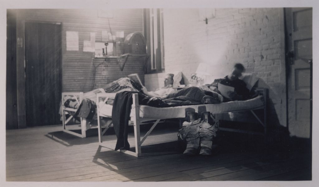
Firefighters Albert Killer and Fred Blake
https://search.heritageburnaby.ca/link/museumdescription1294
- Repository
- Burnaby Village Museum
- Date
- 1939 (date of original)
- Collection/Fonds
- Burnaby Village Museum Photograph collection
- Description Level
- Item
- Physical Description
- 1 photograph : b&w ; 8.5 x 15 cm print
- Scope and Content
- Photograph of Firefighters Albert Killer and Fred Blake lying down on their beds and reading (in the dormitory during the night shift) at No. 1 Burnaby Fire Hall at Carleton Avenue and Eton Street. Fire boots (with fire resistant pants gathered over them) are visible at the side of Fred Blake's bed.
- Repository
- Burnaby Village Museum
- Collection/Fonds
- Burnaby Village Museum Photograph collection
- Description Level
- Item
- Physical Description
- 1 photograph : b&w ; 8.5 x 15 cm print
- Material Details
- .
- Scope and Content
- Photograph of Firefighters Albert Killer and Fred Blake lying down on their beds and reading (in the dormitory during the night shift) at No. 1 Burnaby Fire Hall at Carleton Avenue and Eton Street. Fire boots (with fire resistant pants gathered over them) are visible at the side of Fred Blake's bed.
- Geographic Access
- Carleton Avenue
- Eton Street
- Accession Code
- BV998.31.3
- Access Restriction
- No restrictions
- Reproduction Restriction
- No known restrictions
- Date
- 1939 (date of original)
- Media Type
- Photograph
- Historic Neighbourhood
- Vancouver Heights (Historic Neighbourhood)
- Planning Study Area
- Burnaby Heights Area
- Scan Resolution
- 600
- Scan Date
- 02-Jun-09
- Scale
- 100
- Notes
- Title based on contents of photograph
- Typed sticker on verso of photograph reads: "Night shift at No.1 Hall/ Carleton Ave. and Eton St. (L) Albert Killer (R) Fred Blake 1939"
- Address sticker on verso of photograph reads: "MR & MRS F BLAKE 4165 PANDORA ST BURNABY BC V5C 2B2"
Images
![MacDonald house, [1930] thumbnail](/media/hpo/_Data/_Archives_Images/_Unrestricted/371/476-005.jpg?width=280)
MacDonald house
https://search.heritageburnaby.ca/link/archivedescription38662
- Repository
- City of Burnaby Archives
- Date
- [1930]
- Collection/Fonds
- Burnaby Historical Society fonds
- Description Level
- Item
- Physical Description
- 1 photograph : sepia ; 14.5 x 20.5 cm
- Scope and Content
- Photograph of the Angus and Margaret MacDonald house located at Oxford Street and Esmond Avenue. The MacDonald House is one of Burnaby’s landmark residential heritage buildings and was built in 1909 as part of the exclusive subdivision known as “Vancouver Heights.” The family came to Vancouver fro…
- Repository
- City of Burnaby Archives
- Date
- [1930]
- Collection/Fonds
- Burnaby Historical Society fonds
- Subseries
- North Burnaby Board of Trade subseries
- Physical Description
- 1 photograph : sepia ; 14.5 x 20.5 cm
- Description Level
- Item
- Record No.
- 476-005
- Access Restriction
- No restrictions
- Reproduction Restriction
- No known restrictions
- Accession Number
- BHS2005-8
- Scope and Content
- Photograph of the Angus and Margaret MacDonald house located at Oxford Street and Esmond Avenue. The MacDonald House is one of Burnaby’s landmark residential heritage buildings and was built in 1909 as part of the exclusive subdivision known as “Vancouver Heights.” The family came to Vancouver from Nova Scotia in 1891 and Angus MacDonald, an electrical contractor, served as a Councillor for the City of Vancouver from 1904-1908. Upon his retirement from the B.C. Electric Railway Company, he moved to Burnaby and was a prominent resident serving his North Burnaby ‘Ward’ as a Burnaby Councillor between 1911 and 1916. MacDonald Street in Burnaby was named in his honour. This house which cost $7,000 to construct is reputed to have been the second house built in the Vancouver Heights subdivision. After the death of Margaret MacDonald in 1939 and Angus MacDonald in 1941, the MacDonald family sold the house in 1944 to local grocer John R. and Anne Roane. In 1956, the property was purchased by the late Dr. John Alex MacDonald and his wife Violet E. MacDonald.
- Media Type
- Photograph
- Notes
- Title based on contents of photograph
- Geographic Access
- Oxford Street
- Esmond Avenue
- Street Address
- 3814 Oxford Street
- Historic Neighbourhood
- Vancouver Heights (Historic Neighbourhood)
- Planning Study Area
- Burnaby Heights Area
Images
![MacDonald house, [1930] thumbnail](/media/hpo/_Data/_Archives_Images/_Unrestricted/371/476-005.jpg)
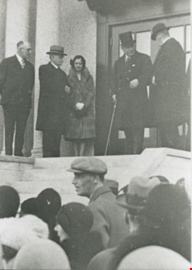
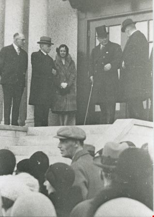
Opening of the Vancouver Heights Presbyterian Church
https://search.heritageburnaby.ca/link/archivedescription35556
- Repository
- City of Burnaby Archives
- Date
- 1931
- Collection/Fonds
- Burnaby Historical Society fonds
- Description Level
- Item
- Physical Description
- 1 photograph : b&w ; 12.7 x 17.8 cm print
- Scope and Content
- Photograph of the official opening of the Vancouver Heights Presbyterian Church at 140 Esmond Avenue at Pandora Street during the Great Depression. The opening followed years of financial difficulty and a breakaway from the Presbytery. The church was dedicated by the Lieutenant Governor of British …
- Repository
- City of Burnaby Archives
- Date
- 1931
- Collection/Fonds
- Burnaby Historical Society fonds
- Subseries
- Pioneer Tales subseries
- Physical Description
- 1 photograph : b&w ; 12.7 x 17.8 cm print
- Description Level
- Item
- Record No.
- 204-414
- Access Restriction
- No restrictions
- Reproduction Restriction
- No known restrictions
- Accession Number
- BHS1988-03
- Scope and Content
- Photograph of the official opening of the Vancouver Heights Presbyterian Church at 140 Esmond Avenue at Pandora Street during the Great Depression. The opening followed years of financial difficulty and a breakaway from the Presbytery. The church was dedicated by the Lieutenant Governor of British Columbia (in top hat).
- Media Type
- Photograph
- Notes
- Title based on contents of photograph
- Geographic Access
- Esmond Avenue
- Street Address
- 140 Esmond Avenue
- Historic Neighbourhood
- Vancouver Heights (Historic Neighbourhood)
- Planning Study Area
- Burnaby Heights Area
Images
Standard Oil
https://search.heritageburnaby.ca/link/archivedescription35189
- Repository
- City of Burnaby Archives
- Date
- 1936 (date of original), copied 1986
- Collection/Fonds
- Burnaby Historical Society fonds
- Description Level
- Item
- Physical Description
- 1 photograph : b&w ; 12.7 x 17.8 cm print
- Scope and Content
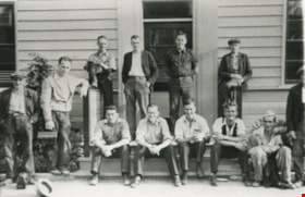
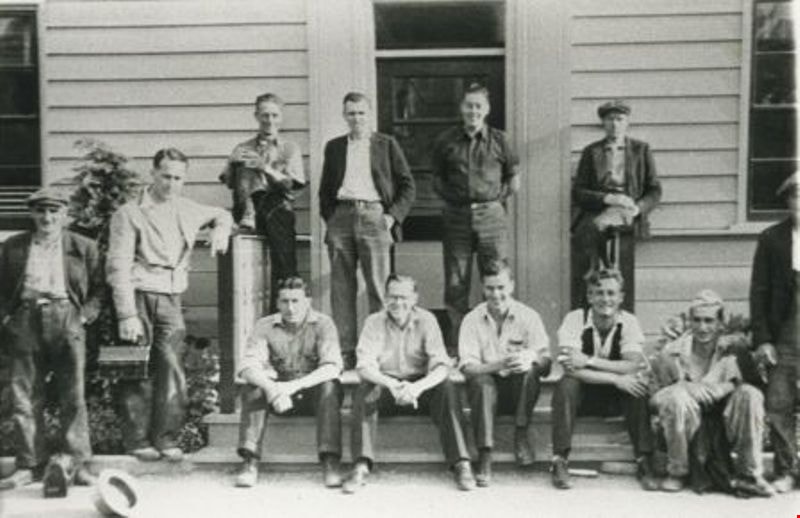
- Photograph of Standard Oil staff, office and refinery at the foot of Queen's Avenue (later renamed Willingdon Avenue). Manager, Mr. Donaldson, is to left; his son, Tommy, is second left. This later became the site of Chevron's Stanovan plant at 4403 Eton Street.
- Repository
- City of Burnaby Archives
- Date
- 1936 (date of original), copied 1986
- Collection/Fonds
- Burnaby Historical Society fonds
- Subseries
- Pioneer Tales subseries
- Physical Description
- 1 photograph : b&w ; 12.7 x 17.8 cm print
- Description Level
- Item
- Record No.
- 204-046
- Access Restriction
- No restrictions
- Reproduction Restriction
- No known restrictions
- Accession Number
- BHS1988-03
- Scope and Content
- Photograph of Standard Oil staff, office and refinery at the foot of Queen's Avenue (later renamed Willingdon Avenue). Manager, Mr. Donaldson, is to left; his son, Tommy, is second left. This later became the site of Chevron's Stanovan plant at 4403 Eton Street.
- Subjects
- Buildings - Industrial - Refineries
- Media Type
- Photograph
- Notes
- Title based on contents of photograph
- Geographic Access
- Eton Street
- Street Address
- 4403 Eton Street
- Historic Neighbourhood
- Vancouver Heights (Historic Neighbourhood)
- Planning Study Area
- Burnaby Heights Area
Images

Standard Oil Company
https://search.heritageburnaby.ca/link/archivedescription34565
- Repository
- City of Burnaby Archives
- Date
- 1936
- Collection/Fonds
- Burnaby Historical Society fonds
- Description Level
- Item
- Physical Description
- 1 photograph : b&w ; 27.2 x 35.0 cm
- Scope and Content
- Photograph of the Standard Oil Company Stanovan Refinery process area, at the Burrard Inlet.
- Repository
- City of Burnaby Archives
- Date
- 1936
- Collection/Fonds
- Burnaby Historical Society fonds
- Subseries
- Photographs subseries
- Physical Description
- 1 photograph : b&w ; 27.2 x 35.0 cm
- Description Level
- Item
- Record No.
- 052-001
- Access Restriction
- No restrictions
- Reproduction Restriction
- No known restrictions
- Accession Number
- BHS2007-04
- Scope and Content
- Photograph of the Standard Oil Company Stanovan Refinery process area, at the Burrard Inlet.
- Subjects
- Buildings - Industrial - Refineries
- Media Type
- Photograph
- Notes
- Title based on contents of photograph
- Geographic Access
- Eton Street
- Street Address
- 4403 Eton Street
- Historic Neighbourhood
- Vancouver Heights (Historic Neighbourhood)
- Planning Study Area
- Burnaby Heights Area
Images

![Standard Oil land clearing, [1935] (date of original), copied 1986 thumbnail](/media/hpo/_Data/_Archives_Images/_Unrestricted/204/204-043.jpg?width=280)
Standard Oil land clearing
https://search.heritageburnaby.ca/link/archivedescription35186
- Repository
- City of Burnaby Archives
- Date
- [1935] (date of original), copied 1986
- Collection/Fonds
- Burnaby Historical Society fonds
- Description Level
- Item
- Physical Description
- 1 photograph : b&w ; 12.7 x 17.8 cm print
- Scope and Content
- Photograph of land being cleared for the Standard Oil Refinery in North Burnaby. The refinery was commonly call Stanovan and was located at the foot of Queens Avenue (now Willingdon street). This later became the site of Chevron's Stanovan plant at 4403 Eton Street.
- Repository
- City of Burnaby Archives
- Date
- [1935] (date of original), copied 1986
- Collection/Fonds
- Burnaby Historical Society fonds
- Subseries
- Pioneer Tales subseries
- Physical Description
- 1 photograph : b&w ; 12.7 x 17.8 cm print
- Description Level
- Item
- Record No.
- 204-043
- Access Restriction
- No restrictions
- Reproduction Restriction
- No known restrictions
- Accession Number
- BHS1988-03
- Scope and Content
- Photograph of land being cleared for the Standard Oil Refinery in North Burnaby. The refinery was commonly call Stanovan and was located at the foot of Queens Avenue (now Willingdon street). This later became the site of Chevron's Stanovan plant at 4403 Eton Street.
- Subjects
- Land Clearing
- Media Type
- Photograph
- Notes
- Title based on contents of photograph
- Geographic Access
- Eton Street
- Street Address
- 4403 Eton Street
- Historic Neighbourhood
- Vancouver Heights (Historic Neighbourhood)
- Planning Study Area
- Burnaby Heights Area
Images
![Standard Oil land clearing, [1935] (date of original), copied 1986 thumbnail](/media/hpo/_Data/_Archives_Images/_Unrestricted/204/204-043.jpg)
![Stanovan Plant, [1936] (date of original), copied 1986 thumbnail](/media/hpo/_Data/_Archives_Images/_Unrestricted/204/204-044.jpg?width=280)
Stanovan Plant
https://search.heritageburnaby.ca/link/archivedescription35187
- Repository
- City of Burnaby Archives
- Date
- [1936] (date of original), copied 1986
- Collection/Fonds
- Burnaby Historical Society fonds
- Description Level
- Item
- Physical Description
- 1 photograph : b&w ; 12.7 x 17.8 cm print
- Scope and Content
- Photograph of two men taken at the foot of Queens Avenue (now Willingdon Avenue) of a Standard Oil refinery commonly called Stanovan. This later became the site of Chevron's Stanovan plant at 4403 Eton Street.
- Repository
- City of Burnaby Archives
- Date
- [1936] (date of original), copied 1986
- Collection/Fonds
- Burnaby Historical Society fonds
- Subseries
- Pioneer Tales subseries
- Physical Description
- 1 photograph : b&w ; 12.7 x 17.8 cm print
- Description Level
- Item
- Record No.
- 204-044
- Access Restriction
- No restrictions
- Reproduction Restriction
- No known restrictions
- Accession Number
- BHS1988-03
- Scope and Content
- Photograph of two men taken at the foot of Queens Avenue (now Willingdon Avenue) of a Standard Oil refinery commonly called Stanovan. This later became the site of Chevron's Stanovan plant at 4403 Eton Street.
- Subjects
- Buildings - Industrial - Refineries
- Media Type
- Photograph
- Notes
- Title based on contents of photograph
- Geographic Access
- Eton Street
- Street Address
- 4403 Eton Street
- Historic Neighbourhood
- Vancouver Heights (Historic Neighbourhood)
- Planning Study Area
- Burnaby Heights Area
Images
![Stanovan Plant, [1936] (date of original), copied 1986 thumbnail](/media/hpo/_Data/_Archives_Images/_Unrestricted/204/204-044.jpg)
![Stanovan Plant, [1936] (date of original), copied 1986 thumbnail](/media/hpo/_Data/_Archives_Images/_Unrestricted/204/204-045.jpg?width=280)
Stanovan Plant
https://search.heritageburnaby.ca/link/archivedescription35188
- Repository
- City of Burnaby Archives
- Date
- [1936] (date of original), copied 1986
- Collection/Fonds
- Burnaby Historical Society fonds
- Description Level
- Item
- Physical Description
- 1 photograph : b&w ; 12.7 x 17.8 cm print
- Scope and Content
- Photograph of two men taken at the foot of Queens Avenue (now Willingdon Avenue) of a Standard Oil refinery commonly called Stanovan. This later became the site of Chevron's Stanovan plant at 4403 Eton Street.
- Repository
- City of Burnaby Archives
- Date
- [1936] (date of original), copied 1986
- Collection/Fonds
- Burnaby Historical Society fonds
- Subseries
- Pioneer Tales subseries
- Physical Description
- 1 photograph : b&w ; 12.7 x 17.8 cm print
- Description Level
- Item
- Record No.
- 204-045
- Access Restriction
- No restrictions
- Reproduction Restriction
- No known restrictions
- Accession Number
- BHS1988-03
- Scope and Content
- Photograph of two men taken at the foot of Queens Avenue (now Willingdon Avenue) of a Standard Oil refinery commonly called Stanovan. This later became the site of Chevron's Stanovan plant at 4403 Eton Street.
- Subjects
- Buildings - Industrial - Refineries
- Media Type
- Photograph
- Notes
- Title based on contents of photograph
- Geographic Access
- Eton Street
- Street Address
- 4403 Eton Street
- Historic Neighbourhood
- Vancouver Heights (Historic Neighbourhood)
- Planning Study Area
- Burnaby Heights Area
Images
![Stanovan Plant, [1936] (date of original), copied 1986 thumbnail](/media/hpo/_Data/_Archives_Images/_Unrestricted/204/204-045.jpg)