Narrow Results By
Creator
- Bateman, Caroline Mary Wettenhall 1
- Brown, William Thomas 1
- Burnaby Art Gallery 1
- Burnaby Public Library 1
- Burnett & McGugan, Engineers and Surveyors 7
- Buxton, George Searby 1
- Buxton, Leopold George 1
- Cecil Croker Fox 1
- Challoner-Courtenay, E.J. 2
- Cooksley, William Thomas 5
- Cornish, New Westminster, BC 2
- Dalton & Eveleigh 1
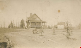
![Louis Claude Hill's Farm, Burnaby, BC, [1909] thumbnail](/media/hpo/_Data/_BVM_Images/1973/1973_0040_0004_001.jpg?width=280)
Louis Claude Hill's Farm, Burnaby, BC
https://search.heritageburnaby.ca/link/museumdescription3064
- Repository
- Burnaby Village Museum
- Date
- [1909]
- Collection/Fonds
- Burnaby Village Museum Photograph collection
- Description Level
- Item
- Physical Description
- 1 photograph : b&w ; 12.2 x 17.6 cm mounted on cardboard 22.7 x 27.4 cm
- Scope and Content
- Photograph of a farm with men, a horse and wagon, and children in a field. An annotation on the back of one of the photos reads, "The foreground farm property stood at the corner of Sperling Avenue (formerly known as the Pole Line Road) and Buckingham. The white house in the left centre was the …
- Repository
- Burnaby Village Museum
- Collection/Fonds
- Burnaby Village Museum Photograph collection
- Description Level
- Item
- Physical Description
- 1 photograph : b&w ; 12.2 x 17.6 cm mounted on cardboard 22.7 x 27.4 cm
- Scope and Content
- Photograph of a farm with men, a horse and wagon, and children in a field. An annotation on the back of one of the photos reads, "The foreground farm property stood at the corner of Sperling Avenue (formerly known as the Pole Line Road) and Buckingham. The white house in the left centre was the residence of Miss Woodward, her mother and sister. It was the first post office at 'Burnaby Lake' and the site of the kindergarten school of Miss Harriet Woodward. It later became the United Church. / The open field in the distance above the horse's head and people in the field is the field in front of the 'Manor House' which was built by Mr. Bateman in the 1920's. To the right of and beyond the white house partly hidden by the trees can be seen some of the buildings associated with the Hill farm on Deer Lake Ave. which by the date (1909) of this photo had been sold. The distant tall trees (center) stand on the site of the Municipal Buildings (DesBirsays Woods)." An annotation on the back of the other photograph reads, "Formerly belonging to Malcom Nicolson / App. 1908." Annotations at the bottom front of the photograph read, "L. Claude Hill's Farm, Burnaby, BC."
- Subjects
- Agriculture - Crops
- Agricultural Tools and Equipment
- Animals - Horses
- Occupations - Farmers
- Agriculture - Farms
- Geographic Access
- Buckingham Avenue
- Sperling Avenue
- Accession Code
- HV973.40.4
- Access Restriction
- No restrictions
- Reproduction Restriction
- No known restrictions
- Date
- [1909]
- Media Type
- Photograph
- Historic Neighbourhood
- Burnaby Lake (Historic Neighbourhood)
- Planning Study Area
- Morley-Buckingham Area
- Scan Resolution
- 600
- Scan Date
- 2023-05-09
- Scale
- 100
- Notes
- Title based on contents of photograph
- 1 b&w duplicate photograph accompanying
- Text on first image "L Claude Hill's Farm, Burnaby B C", incorporated into the image at the bottom edge of the photograph. "app 1909" pencilled in following above on the bottom edge of the image "L. Claude / Hill / Broadview", pencilled on the matt below the image. "The foreground farm property stood at the / Corner of Sperling Ave. (formerly known as Pole Line Road) / and Buckingham. The white house in the left / centre was the residence of Miss Woodward, her mother / and sister. It was the first post ofice at "Burnaby Lake" / and the site of the kindergarten school of Miss / Harriet Woodward. It later became the United / Church. / The open field in the distance above / the horses head and people in the field is / the field in front of the "Manse House" which / was built by Mr. Bateman in the 1920's. To the / right of and beyond the white house partly hidden / by the trees can be seen some of the buildings / associated with the Hill farm on Deer Lake Ave. / which by the date (1909) of this photo had been / sold. The distant tall trees (center) stand on the site of / the Municipal Buildings (DesBirsays Woods)", hand written in blue ink on the reverse side of the matt. It is not indicated who wrote the note. "OR MASTER / 973.40.4", pencilled in the lower right corner of reverse side of matt. "W. T. COOKSLEY / NEW WESTMINSTER, B.C."printed with very little contrast on the gray mattboard, below the lower right corner of the photograph Text on second image. "L Claude Hill's Farm, Burnaby B C", incorporated into the image at the bottom edge of the photograph. "Claude surveying the haying", pencilled on the reverse side of the matt. "Formerly belonging to Malcolm Nicholson / app 1908", hand writen in blue ink on the reverse side of the matt. "H.V.973.40.4. OR. MASTER", hand printed on the bottom left corner of the reverse side of the matt. "W. T. COOKSLEY / NEW WESTMINSTER, B.C."printed with very little contrast on the gray mattboard, below the lower right corner of the photograph
Images
![Louis Claude Hill's Farm, Burnaby, BC, [1909] thumbnail](/media/hpo/_Data/_BVM_Images/1973/1973_0040_0004_001.jpg)

Jim Wolf subseries
https://search.heritageburnaby.ca/link/archivedescription97451
- Repository
- City of Burnaby Archives
- Date
- 1909 (date of original)-1986
- Collection/Fonds
- Burnaby Historical Society fonds
- Description Level
- Subseries
- Physical Description
- Photographs
- Scope and Content
- Subseries consists of photographs compiled by Jim Wolf for the Burnaby Historical Society during his time working with the Society and as the Heritage Planner for the City of Burnaby. Photographs primarily depict notable Burnaby locations and buildings, including Barnet, Our Lady of Mercy Church M…
- Repository
- City of Burnaby Archives
- Date
- 1909 (date of original)-1986
- Collection/Fonds
- Burnaby Historical Society fonds
- Subseries
- Jim Wolf subseries
- Physical Description
- Photographs
- Description Level
- Subseries
- Accession Number
- BHS1986-39
- BHS1997-9
- BHS1998-13
- BHS2000-11
- BHS2004-9
- BHS2005-6
- Scope and Content
- Subseries consists of photographs compiled by Jim Wolf for the Burnaby Historical Society during his time working with the Society and as the Heritage Planner for the City of Burnaby. Photographs primarily depict notable Burnaby locations and buildings, including Barnet, Our Lady of Mercy Church Manse, and the D.C. Patterson house.
- Media Type
- Photograph
- Creator
- Wolf, Jim
- Notes
- Title based on creator of subseries
- PC188, PC349, PC350, PC363, PC410, PC401, PC474, PC466

Angus & Margaret MacDonald House
https://search.heritageburnaby.ca/link/landmark495
- Repository
- Burnaby Heritage Planning
- Description
- Set on a large corner lot at North Esmond Avenue and Oxford Street, the Angus & Margaret MacDonald House is a prominent, two and one-half storey Queen Anne Revival-style residence. The high hipped roof has open projecting gables. The house is a landmark within the Vancouver Heights neighbourhood of…
- Associated Dates
- 1909
- Formal Recognition
- Heritage Designation, Community Heritage Register
- Street View URL
- Google Maps Street View
- Repository
- Burnaby Heritage Planning
- Geographic Access
- Oxford Street
- Associated Dates
- 1909
- Formal Recognition
- Heritage Designation, Community Heritage Register
- Enactment Type
- Bylaw No. 12174
- Enactment Date
- 11/12/2006
- Description
- Set on a large corner lot at North Esmond Avenue and Oxford Street, the Angus & Margaret MacDonald House is a prominent, two and one-half storey Queen Anne Revival-style residence. The high hipped roof has open projecting gables. The house is a landmark within the Vancouver Heights neighbourhood of North Burnaby, on a high point of land overlooking Burrard Inlet and the North Shore Mountains.
- Heritage Value
- The MacDonald House is valued as one of Burnaby’s most elaborate examples of the Queen Anne Revival style. The house retains many of its original features, including a prominent front corner turret wrapped by a clamshell verandah. The eclectic and transitional nature of Edwardian-era architecture is demonstrated by the late persistence of these Queen Anne Revival details, combined with the use of newly-popular classical revival elements such as Ionic columns. The interior retains a number of original architectural elements, and the early garage at the rear originally housed Angus MacDonald’s Cadillac, one of the first known automobiles owned by a Burnaby resident. Constructed in 1909, this house was built for Angus MacDonald (1857-1943) and his wife, Margaret Isabella Thompson MacDonald (1862-1939). Angus MacDonald, an electrical contractor, relocated from Nova Scotia to Vancouver in 1891 and served on Vancouver Council from 1904-08. The MacDonald family moved to Burnaby upon his retirement from the B.C. Electric Railway Company, and he then served the North Burnaby Ward as a councillor from 1911-1916 and again in 1921. MacDonald Street in Burnaby was named in his honour. The MacDonald House has additional significance as one of the surviving landmark residences, built between 1909 and 1914, during the first development of Vancouver Heights. In 1909, C.J. Peter and his employer, G.F. and J. Galt Limited, initiated the development of this North Burnaby neighbourhood, promoting it as one of the most picturesque districts in the region and an alternative to the CPR’s prestigious Shaughnessy Heights development in Vancouver. Buyers were obligated to build houses worth $3,500 at a time when the average house price was $1,000. Reputed to be the second house built in the subdivision, this house cost $7,000 to build.
- Defining Elements
- Key elements that define the heritage character of the MacDonald House include its: - prominent corner location in the Vancouver Heights neighbourhood, with views to Burrard Inlet and the North Shore Mountains - residential form, scale and massing as exemplified by its two and one-half storey height, full basement, compound plan, and high hipped roof with gabled projections at the front and side - wood-frame construction including wooden lapped siding, trim and mouldings - rubble-stone granite foundation - Queen Anne Revival details such as scroll-cut modillions, octagonal corner turret, wraparound, clamshell verandah with classical columns, and projecting square and semi-octagonal bays - external red-brick chimney with corbelled top - original windows including double-hung, 1-over-1 wooden sash windows in single and double assembly, and arched-top casement windows in the gable peaks - original interior features such as the main staircase, a panelled dining room with a fireplace and built-in cabinets, a living room with a parquet floor, and a rear den with an oak mantle and tiled hearth - associated early wood-frame garage at the rear of the property - landscape features such as mature coniferous and deciduous trees surrounding the property
- Historic Neighbourhood
- Vancouver Heights (Historic Neighbourhood)
- Planning Study Area
- Burnaby Heights Area
- Organization
- British Columbia Mills Timber and Trading Company
- Function
- Primary Historic--Single Dwelling
- Primary Current--Single Dwelling
- Community
- Vancouver Heights
- Cadastral Identifier
- P.I.D.011-999-462
- Boundaries
- The MacDonald House is comprised of a single residential lot located at 3814 Oxford Street, Burnaby.
- Area
- 566.71
- Contributing Resource
- Building
- Ownership
- Private
- Documentation
- City of Burnaby Planning and Building Department, Heritage Site Files
- Street Address
- 3814 Oxford Street
- Street View URL
- Google Maps Street View
Images


Joseph Clarke House
https://search.heritageburnaby.ca/link/landmark505
- Repository
- Burnaby Heritage Planning
- Description
- The Joseph Clarke House is a two and one-half storey, wood-frame house, with shingle siding, a front-gabled roof and a full open front verandah. It is located on Jersey Avenue within the Central Park neighbourhood of Burnaby.
- Associated Dates
- 1909
- Formal Recognition
- Heritage Designation, Community Heritage Register
- Other Names
- Joseph & Ellen Clarke House, Clarke Residence
- Street View URL
- Google Maps Street View
- Repository
- Burnaby Heritage Planning
- Other Names
- Joseph & Ellen Clarke House, Clarke Residence
- Geographic Access
- Jersey Avenue
- Sandell Street
- Associated Dates
- 1909
- Formal Recognition
- Heritage Designation, Community Heritage Register
- Enactment Type
- By-law No. 11930
- Enactment Date
- 29/08/2005
- Description
- The Joseph Clarke House is a two and one-half storey, wood-frame house, with shingle siding, a front-gabled roof and a full open front verandah. It is located on Jersey Avenue within the Central Park neighbourhood of Burnaby.
- Heritage Value
- Built circa 1909 for Central Park farmer Joseph Clarke (1851-1936) and his wife, Ellen (1864-1938), this Edwardian-era farm house is valued for its vernacular design, which demonstrates the utilitarian nature of working-class housing during the boom years prior to the First World War. The Joseph Clarke House is additionally valued for its link with the development of the Central Park neighbourhood during the Edwardian era. The advent of the Central Park interurban rail line in 1892, operated by the B.C. Electric Company, connected the area to Vancouver and led to its suburban development. This is one of the oldest surviving houses in the Central Park neighbourhood. It was designated as a municipal heritage site in 2005 and rehabilitated as part of the adjacent multi-family townhouse and apartment redevelopment.
- Defining Elements
- Key elements that define the heritage character of the Joseph Clarke House include its: - location on Jersey Avenue in the Central Park neighbourhood - residential form, scale and massing as expressed by its two and one-half storey height with rectangular plan, front bay window and front-gabled roof - wood-frame construction - Edwardian era detailing such as the open front verandah, asymmetrical front entrance, glazed front door with sidelights and triangular eave brackets
- Historic Neighbourhood
- Central Park (Historic Neighbourhood)
- Planning Study Area
- Garden Village Area
- Function
- Primary Historic--Single Dwelling
- Primary Current--Single Dwelling
- Community
- Burnaby
- Cadastral Identifier
- P.I.D. 027-101-428
- Boundaries
- The Joseph Clarke House is comprised of a single residential lot located at 5575 Jersey Avenue, Burnaby.
- Area
- 2370
- Contributing Resource
- Building
- Ownership
- Private
- Documentation
- City of Burnaby Planning and Building Department, Heritage Site Files
- Names
- Clarke, Joseph
- Clarke, Ellen
- Street Address
- 5575 Jersey Avenue
- Street View URL
- Google Maps Street View
Images


Overlynn Mansion
https://search.heritageburnaby.ca/link/landmark520
- Repository
- Burnaby Heritage Planning
- Description
- Overlynn Mansion is a two and one-half storey British Arts and Crafts mansion, with an exterior composed of a massive native granite rubble-stone base surmounted by distinctive half-timbering, a hip hipped roof, a rare surviving intact interior, and elaborate landscape features including stone wall…
- Associated Dates
- 1909
- Formal Recognition
- Heritage Designation, Community Heritage Register
- Other Names
- Charles J. Peter Mansion
- Street View URL
- Google Maps Street View
- Repository
- Burnaby Heritage Planning
- Other Names
- Charles J. Peter Mansion
- Geographic Access
- McGill Street
- Associated Dates
- 1909
- Formal Recognition
- Heritage Designation, Community Heritage Register
- Enactment Type
- Bylaw No. 10211
- Enactment Date
- 18/09/1995
- Description
- Overlynn Mansion is a two and one-half storey British Arts and Crafts mansion, with an exterior composed of a massive native granite rubble-stone base surmounted by distinctive half-timbering, a hip hipped roof, a rare surviving intact interior, and elaborate landscape features including stone walls and planted terraces. It is situated in the residential neighbourhood of Vancouver Heights, on a high point of land overlooking Burrard Inlet to the west and the mouth of Lynn Creek to the east. This prominent residence is now part of a large senior citizens development known as Seton Villa.
- Heritage Value
- Overlynn Mansion is valued as a superb example of the work of the noted architectural firm of Maclure and Fox. The architecture of Samuel Maclure (1860-1929) was synonymous with high quality residential design for prominent citizens in both Vancouver and Victoria. Maclure was known for his British Arts and Crafts style with meticulous attention paid to functional and beautiful interiors that utilized native wood combined with luxurious imported fittings. He was a leading exponent of the Art and Crafts design movement in B.C., and established a sophisticated local variation of residential architecture. Maclure’s Vancouver office, in association with his partner Cecil Croker Fox (1879-1916), received some sixty residential commissions between 1909-1915 as a result of the booming local economy and subsequent development of new residential districts. Maclure’s practice in Victoria was equally prolific at the time. Overlynn Mansion is valued as one of Burnaby’s oldest upper-class estates and for its association with the development of Vancouver Heights. In 1909, C.J. Peter and his employer, G.F. and J. Galt Limited, pioneered the development of Vancouver Heights in North Burnaby, believing it to be one of the most picturesque districts in area and an alternative to the CPR’s prestigious Shaughnessy Heights development in Vancouver. Buyers were obligated to build houses worth $3,500 at a time when the average house price was $1,000. Overlynn Mansion, built in 1909 for $75,000, was one of the first houses constructed in Vancouver Heights and by far the most grandiose and impressive. Additionally, this landmark residence is significant and an intact and comprehensive representation of a grand Edwardian era estate home. The interior is notably intact, and retains many highly-refined original features, including substantive millwork of exotic woods, silver-plated and nickel-plated light fixtures, fine plasterwork, tiled fireplaces and exceptional hardware. Landscape features of Overlynn Mansion include the original layout for circulation paths, a porte-cochere, granite posts and stone walls, a sandstone and iron sundial, and mature trees and shrubbery. The house was designated by Burnaby Council in 1995 and was the first heritage building in B.C. to receive legal protection for its interior features.
- Defining Elements
- Key elements that define the heritage character of Overlynn Mansion include its: - prominent corner location on a steep sloping site in the Vancouver Heights neighbourhood - views to Burrard Inlet and the North Shore mountains - residential form, scale and massing as exemplified by its grand two-storey plus basement height and irregular plan - British Arts and Crafts elements such as the rubble-stone granite masonry on the ground floor and foundation level, and decorative half-timbering and rough-cast stucco on the upper storey - compound hipped bell-cast roof, clad with cedar shingles, with shed dormers at the rear - subtle battering of ground floor and foundation level stonework - porte-cochere with hipped roof and battered granite piers - wood-clad projecting bay extensions - irregular fenestration: double-hung 6-over-1 wooden-sash windows; multi-pane casement wooden windows with multi-pane transoms; diamond leaded casement windows; and banks of stained glass windows - five tall rubble-stone granite block stone chimneys - interior features such as the oak, cedar and Yaka (Australian mahogany) panelled walls, oak panelling and staircase walls inlaid with ebony, ivory and brass, stenciled canvas friezes, wooden dadoes and plaster walls, encaustic floor tiles, Australian gumwood floors, oak panelled doors with art glass, oak beamed ceiling with stucco panels, cast plaster vaulted hall and living room ceilings, sterling silver light fixtures including a chandelier and scones, nickel-plated newel light, brass Art Nouveau styled ceiling light, brass stair carpet poles and locks, built-in bookcases and buffet, fireplace with encaustic tiles and fire dogs, imported Medmenham fireplace tiles (the earliest known use outside of the United Kingdom), fireplace mantel with green tile and cast iron firebox, and inglenook fireplace with encaustic tiles and carved mantel and brass fireplace insert - landscape features such as the granite gate posts and iron entrance gate, granite posts and iron fence, granite garden wall, sandstone garden steps, sandstone and iron sundial, granite and concrete terraces adjacent to the house, configuration of pathways and sandstone steps including the front access road, mature deciduous and coniferous tree stock including a Monkey Puzzle Tree and pruned shrubbery throughout the site
- Historic Neighbourhood
- Vancouver Heights (Historic Neighbourhood)
- Planning Study Area
- Burnaby Heights Area
- Organization
- G.F. and J. Galt Limited
- Architect
- Samuel Maclure
- Cecil Croker Fox
- Function
- Primary Historic--Estate
- Primary Current--Multiple Dwelling
- Community
- Burnaby
- Cadastral Identifier
- 004-943-295
- Boundaries
- Overlynn Mansion is a part of a single institutional lot located at 3755 McGill Street, Burnaby.
- Area
- 7912.77
- Contributing Resource
- Building
- Ownership
- Private
- Street Address
- 3755 McGill Street
- Street View URL
- Google Maps Street View
Images


North Pacific Lumber Company Ruins
https://search.heritageburnaby.ca/link/landmark627
- Repository
- Burnaby Heritage Planning
- Geographic Access
- Barnet Road
- Associated Dates
- 1909
- Description
- Industrial building.
- Heritage Value
- Located on the shore of Burrard Inlet, these poured concrete piers of the smokestack burner and the former boiler and plant of the North Pacific Lumber Company are among the only remains of the once-thriving industrial site located on the waterfront on the south shore of Burrard Inlet. The sawmill and the Village of Barnet were initiated by David MacLaren, a wealthy lumberman from Buckingham, Quebec, who had previously established the Fraser Mills in Coquitlam in 1889. McLaren gambled that a sawmill on the main line of the C.P.R near Vancouver would serve the Canadian domestic market and be a profitable venture. The North Pacific Lumber Company established itself on this peninsula on Burrard Inlet and was fully operational in 1900. In 1909, the mill was completely burned out by a fire starting in the boiler room. Immediately the plant was rebuilt, modern in every respect and absolutely fireproof, as the entire power plant and boiler room was built of reinforced concrete and steel, of which these ruins are the last remains. The plant closed during the First World War and reopened as the Barnet Lumber Company in 1925 only to close forever in 1931 after a strike during the Great Depression.
- Locality
- Barnet
- Historic Neighbourhood
- Barnet (Historic Neighbourhood)
- Planning Study Area
- Burnaby Mountain Area
Images


St. Albans The Martyr Anglican Church
https://search.heritageburnaby.ca/link/landmark640
- Repository
- Burnaby Heritage Planning
- Description
- Church building.
- Associated Dates
- 1909
- Street View URL
- Google Maps Street View
- Repository
- Burnaby Heritage Planning
- Geographic Access
- 19th Avenue
- Associated Dates
- 1909
- Description
- Church building.
- Heritage Value
- St. Albans Anglican Church is one of the landmarks of the historic Edmonds district, and has many ties to its neighbourhood history and prominent families of Burnaby. The site was purchased in June 1907 and presented to the congregation by Mr. Walter James Walker that August. Walker, a real estate developer and former Surrey Reeve, donated money for the construction of a number of Anglican churches, including three in North Surrey in 1910. Construction on St. Albans began in November 1908 by contractors Wright & Tucker, and was completed in March 1909. The first vicar was Rev. D. Dunlop, who was also the rector of St. Mary’s in Sapperton. Pre-eminent Vancouver architects Dalton & Eveleigh provided the design. William Dalton (1854-1931) and Sydney Eveleigh (1879-1947) formed their partnership circa 1902, and the firm was highly regarded for the high quality of its commercial and institutional buildings.
- Locality
- Edmonds
- Historic Neighbourhood
- Edmonds (Historic Neighbourhood)
- Planning Study Area
- Edmonds Area
- Architect
- Dalton & Eveleigh
- Area
- 2132.24
- Contributing Resource
- Building
- Ownership
- Private
- Street Address
- 7717 19th Avenue
- Street View URL
- Google Maps Street View
Images


![Agricultural Exhibit, [1909] thumbnail](/media/hpo/_Data/_Archives_Images/_Unrestricted/001/041-001.jpg?width=280)
Agricultural Exhibit
https://search.heritageburnaby.ca/link/archivedescription34530
- Repository
- City of Burnaby Archives
- Date
- [1909]
- Collection/Fonds
- Burnaby Historical Society fonds
- Description Level
- Item
- Physical Description
- 1 photograph : b&w ; 20.4 x 25.2 cm
- Scope and Content
- Photograph of Burnaby's Agricultural Exhibit at New Westminster showing a display of vegetables, fruit, flowers, plants, and trees inside of a building.
- Repository
- City of Burnaby Archives
- Date
- [1909]
- Collection/Fonds
- Burnaby Historical Society fonds
- Subseries
- Photographs subseries
- Physical Description
- 1 photograph : b&w ; 20.4 x 25.2 cm
- Description Level
- Item
- Record No.
- 041-001
- Access Restriction
- No restrictions
- Reproduction Restriction
- No known restrictions
- Accession Number
- BHS2007-04
- Scope and Content
- Photograph of Burnaby's Agricultural Exhibit at New Westminster showing a display of vegetables, fruit, flowers, plants, and trees inside of a building.
- Subjects
- Agriculture - Crops
- Exhibitions - Agricultural
- Agriculture - Fruit and Berries
- Plants - Flowers
- Media Type
- Photograph
- Notes
- Title based on contents of photograph
Images
![Agricultural Exhibit, [1909] thumbnail](/media/hpo/_Data/_Archives_Images/_Unrestricted/001/041-001.jpg)
![St. Alban's Anglican Church, [1909] (date of original), copied 1986 thumbnail](/media/hpo/_Data/_Archives_Images/_Unrestricted/126/171-024.jpg?width=280)
St. Alban's Anglican Church
https://search.heritageburnaby.ca/link/archivedescription35003
- Repository
- City of Burnaby Archives
- Date
- [1909] (date of original), copied 1986
- Collection/Fonds
- Burnaby Historical Society fonds
- Description Level
- Item
- Physical Description
- 1 photograph : b&w postcard ; 8.5 x 11.8 cm
- Scope and Content
- Photograph on a postcard of the exterior of St. Alban's Anglican Church at 7717 19th Avenue, near Douglas Road (now Canada Way) and Edmonds Street.
- Repository
- City of Burnaby Archives
- Date
- [1909] (date of original), copied 1986
- Collection/Fonds
- Burnaby Historical Society fonds
- Subseries
- Patterson family subseries
- Physical Description
- 1 photograph : b&w postcard ; 8.5 x 11.8 cm
- Description Level
- Item
- Record No.
- 171-024
- Access Restriction
- No restrictions
- Reproduction Restriction
- No known restrictions
- Accession Number
- BHS1986-20
- Scope and Content
- Photograph on a postcard of the exterior of St. Alban's Anglican Church at 7717 19th Avenue, near Douglas Road (now Canada Way) and Edmonds Street.
- Media Type
- Photograph
- Notes
- Title based on contents of photograph
- Geographic Access
- 19th Avenue
- Street Address
- 7717 19th Avenue
- Historic Neighbourhood
- Edmonds (Historic Neighbourhood)
- Planning Study Area
- Edmonds Area
Images
![St. Alban's Anglican Church, [1909] (date of original), copied 1986 thumbnail](/media/hpo/_Data/_Archives_Images/_Unrestricted/126/171-024.jpg)
![Grace McGhee, [1909] (date of original), copied 1986 thumbnail](/media/hpo/_Data/_Archives_Images/_Unrestricted/204/204-010.jpg?width=280)
Grace McGhee
https://search.heritageburnaby.ca/link/archivedescription35153
- Repository
- City of Burnaby Archives
- Date
- [1909] (date of original), copied 1986
- Collection/Fonds
- Burnaby Historical Society fonds
- Description Level
- Item
- Physical Description
- 1 photograph : b&w ; 12.7 x 17.8 cm print
- Scope and Content
- Photograph of Grace McGhee (nee George) at McKay station along the Central Park Interurban line.
- Repository
- City of Burnaby Archives
- Date
- [1909] (date of original), copied 1986
- Collection/Fonds
- Burnaby Historical Society fonds
- Subseries
- Pioneer Tales subseries
- Physical Description
- 1 photograph : b&w ; 12.7 x 17.8 cm print
- Description Level
- Item
- Record No.
- 204-010
- Access Restriction
- No restrictions
- Reproduction Restriction
- No known restrictions
- Accession Number
- BHS1988-03
- Scope and Content
- Photograph of Grace McGhee (nee George) at McKay station along the Central Park Interurban line.
- Media Type
- Photograph
- Notes
- Title based on contents of photograph
- Geographic Access
- McKay Avenue
- Central Park Interurban line
- Historic Neighbourhood
- Central Park (Historic Neighbourhood)
- Planning Study Area
- Maywood Area
Images
![Grace McGhee, [1909] (date of original), copied 1986 thumbnail](/media/hpo/_Data/_Archives_Images/_Unrestricted/204/204-010.jpg)

Jubilee Methodist Church
https://search.heritageburnaby.ca/link/archivedescription36018
- Repository
- City of Burnaby Archives
- Date
- 1909
- Collection/Fonds
- Burnaby Historical Society fonds
- Description Level
- Item
- Physical Description
- 1 photograph : sepia postcard ; 8 x 13 cm
- Scope and Content
- Photographic postcard of the Jubilee Methodist Church.
- Repository
- City of Burnaby Archives
- Date
- 1909
- Collection/Fonds
- Burnaby Historical Society fonds
- Subseries
- Ephemera subseries
- Physical Description
- 1 photograph : sepia postcard ; 8 x 13 cm
- Description Level
- Item
- Record No.
- 212-001
- Access Restriction
- No restrictions
- Reproduction Restriction
- No known restrictions
- Accession Number
- BHS1988-12
- Scope and Content
- Photographic postcard of the Jubilee Methodist Church.
- Media Type
- Photograph
- Notes
- Title based on contents of photograph
- Geographic Access
- Sussex Avenue
- Street Address
- 6050 Sussex Avenue
- Historic Neighbourhood
- Central Park (Historic Neighbourhood)
- Planning Study Area
- Marlborough Area
Images

B.G. Walker house
https://search.heritageburnaby.ca/link/archivedescription36021
- Repository
- City of Burnaby Archives
- Date
- 1909
- Collection/Fonds
- Burnaby Historical Society fonds
- Description Level
- Item
- Physical Description
- 1 photograph : sepia postcard ; 8 x 14 cm
- Scope and Content
- Photographic postcard of the B.G. Walker House, at Edmonds & Kingsway.
- Repository
- City of Burnaby Archives
- Date
- 1909
- Collection/Fonds
- Burnaby Historical Society fonds
- Subseries
- Patterson family subseries
- Physical Description
- 1 photograph : sepia postcard ; 8 x 14 cm
- Description Level
- Item
- Record No.
- 213-003
- Access Restriction
- No restrictions
- Reproduction Restriction
- No known restrictions
- Accession Number
- BHS1988-13
- Scope and Content
- Photographic postcard of the B.G. Walker House, at Edmonds & Kingsway.
- Subjects
- Buildings - Residential - Houses
- Media Type
- Photograph
- Notes
- Title based on contents of photograph
- Geographic Access
- Edmonds Street
- Street Address
- 7328 Edmonds Street
- Historic Neighbourhood
- Edmonds (Historic Neighbourhood)
- Planning Study Area
- Richmond Park Area
Images

![Pengelly's logging shack, [1909] thumbnail](/media/hpo/_Data/_Archives_Images/_Unrestricted/205/222-005.jpg?width=280)
Pengelly's logging shack
https://search.heritageburnaby.ca/link/archivedescription36082
- Repository
- City of Burnaby Archives
- Date
- [1909]
- Collection/Fonds
- Burnaby Historical Society fonds
- Description Level
- Item
- Physical Description
- 1 photograph : b&w ; 9 x 11.5 cm
- Scope and Content
- Photograph of Pengelly's logging shack, believed to be at Union Street and Duthie Avenue. One lumberjack is standing just outside the shack with an axe in his hand, while another is wiping his face with a cloth and a third is standing with one foot bracing a felled log with a saw in his hand.
- Repository
- City of Burnaby Archives
- Date
- [1909]
- Collection/Fonds
- Burnaby Historical Society fonds
- Subseries
- Columbian Newspaper subseries
- Physical Description
- 1 photograph : b&w ; 9 x 11.5 cm
- Description Level
- Item
- Record No.
- 222-005
- Access Restriction
- No restrictions
- Reproduction Restriction
- No known restrictions
- Accession Number
- BHS1989-19
- Scope and Content
- Photograph of Pengelly's logging shack, believed to be at Union Street and Duthie Avenue. One lumberjack is standing just outside the shack with an axe in his hand, while another is wiping his face with a cloth and a third is standing with one foot bracing a felled log with a saw in his hand.
- Media Type
- Photograph
- Notes
- Title based on contents of photograph
- 2 b&w copy negatives accompanying
- Geographic Access
- Duthie Avenue
- Union Street
- Historic Neighbourhood
- Lochdale (Historic Neighbourhood)
- Planning Study Area
- Lochdale Area
Images
![Pengelly's logging shack, [1909] thumbnail](/media/hpo/_Data/_Archives_Images/_Unrestricted/205/222-005.jpg)
![Barnet Mill being rebuilt, [1909] (date of original), copied [1998] thumbnail](/media/hpo/_Data/_Archives_Images/_Unrestricted/316/363-002.jpg?width=280)
Barnet Mill being rebuilt
https://search.heritageburnaby.ca/link/archivedescription37363
- Repository
- City of Burnaby Archives
- Date
- [1909] (date of original), copied [1998]
- Collection/Fonds
- Burnaby Historical Society fonds
- Description Level
- Item
- Physical Description
- 1 photograph : b&w ; 10 x 15 cm print
- Scope and Content
- Photograph of lumber piled up and the skeleton of a building being framed during the rebuilding of the Barnet Mill after the fire of 1909. The Barnet Mill was called the North Pacific Lumber Company from 1889 to 1914.
- Repository
- City of Burnaby Archives
- Date
- [1909] (date of original), copied [1998]
- Collection/Fonds
- Burnaby Historical Society fonds
- Subseries
- Jim Wolf subseries
- Physical Description
- 1 photograph : b&w ; 10 x 15 cm print
- Description Level
- Item
- Record No.
- 363-002
- Access Restriction
- No restrictions
- Reproduction Restriction
- No known restrictions
- Accession Number
- BHS1998-13
- Scope and Content
- Photograph of lumber piled up and the skeleton of a building being framed during the rebuilding of the Barnet Mill after the fire of 1909. The Barnet Mill was called the North Pacific Lumber Company from 1889 to 1914.
- Names
- Barnet Mill
- Media Type
- Photograph
- Notes
- Title based on contents of photograph
- Geographic Access
- Barnet Village
- Texaco Drive
- Street Address
- 8059 Texaco Drive
- Historic Neighbourhood
- Barnet (Historic Neighbourhood)
- Planning Study Area
- Burnaby Mountain Area
Images
![Barnet Mill being rebuilt, [1909] (date of original), copied [1998] thumbnail](/media/hpo/_Data/_Archives_Images/_Unrestricted/316/363-002.jpg)

Mills Burning at Barnet
https://search.heritageburnaby.ca/link/archivedescription38342
- Repository
- City of Burnaby Archives
- Date
- May 6, 1909
- Collection/Fonds
- Burnaby Historical Society fonds
- Description Level
- Item
- Physical Description
- 1 photograph : sepia postcard ; 8 x 13.4 cm
- Scope and Content
- Photographic postcard of the line of buildings burning at the North Pacific Lumber Company, with flames and smoke visible rising from the structures. A caption stamped at the top of the postcard reads: "Mills burning at Barnet BC. 1:30a.m. May 6th, 1909."
- Repository
- City of Burnaby Archives
- Date
- May 6, 1909
- Collection/Fonds
- Burnaby Historical Society fonds
- Subseries
- Charles Lee subseries
- Physical Description
- 1 photograph : sepia postcard ; 8 x 13.4 cm
- Description Level
- Item
- Record No.
- 411-001
- Access Restriction
- No restrictions
- Reproduction Restriction
- No known restrictions
- Accession Number
- BHS2000-13
- Scope and Content
- Photographic postcard of the line of buildings burning at the North Pacific Lumber Company, with flames and smoke visible rising from the structures. A caption stamped at the top of the postcard reads: "Mills burning at Barnet BC. 1:30a.m. May 6th, 1909."
- Names
- Barnet Mill
- Media Type
- Photograph
- Geographic Access
- Barnet Village
- Texaco Drive
- Street Address
- 8059 Texaco Drive
- Historic Neighbourhood
- Barnet (Historic Neighbourhood)
- Planning Study Area
- Burnaby Mountain Area
Images

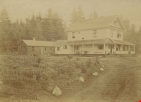
Broadview
https://search.heritageburnaby.ca/link/archivedescription39426
- Repository
- City of Burnaby Archives
- Date
- 1909
- Collection/Fonds
- Peers Family and Hill Family fonds
- Description Level
- Item
- Physical Description
- 1 photograph : sepia ; 7.4 x 10 cm
- Scope and Content
- Photograph of the Hill family home, Broadview, in the Burnaby Lake district.
- Repository
- City of Burnaby Archives
- Date
- 1909
- Collection/Fonds
- Peers Family and Hill Family fonds
- Physical Description
- 1 photograph : sepia ; 7.4 x 10 cm
- Description Level
- Item
- Record No.
- 477-745
- Access Restriction
- No restrictions
- Reproduction Restriction
- No known restrictions
- Accession Number
- 2007-12
- Scope and Content
- Photograph of the Hill family home, Broadview, in the Burnaby Lake district.
- Subjects
- Buildings - Residential - Houses
- Media Type
- Photograph
- Notes
- Title based on caption accompanying photograph
- Geographic Access
- Buckingham Avenue
- Street Address
- 5730 Buckingham Avenue
- Historic Neighbourhood
- Burnaby Lake (Historic Neighbourhood)
- Planning Study Area
- Morley-Buckingham Area
Images
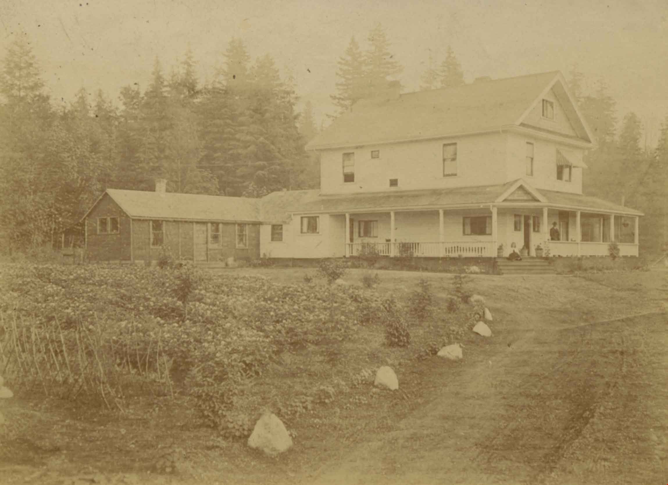

First School at Burnaby Lake
https://search.heritageburnaby.ca/link/archivedescription39549
- Repository
- City of Burnaby Archives
- Date
- 1909
- Collection/Fonds
- Peers Family and Hill Family fonds
- Description Level
- Item
- Physical Description
- 1 photograph : b&w ; 12.5 x 17 cm on page 21.5 x 28 cm (pasted in album)
- Scope and Content
- Photograph of Harriet Woodward and her class of students outside the Woodward home near Deer Lake which served as the first school and post office in the Burnaby Lake area; (l to r): Harriet Woodward (Miss Harry), Bob Peers, Melvin Mawhinney, Muriel Sprott, Kitty Hill, Beatrice Clayton and Arthur P…
- Repository
- City of Burnaby Archives
- Date
- 1909
- Collection/Fonds
- Peers Family and Hill Family fonds
- Physical Description
- 1 photograph : b&w ; 12.5 x 17 cm on page 21.5 x 28 cm (pasted in album)
- Description Level
- Item
- Record No.
- 477-868
- Access Restriction
- No restrictions
- Reproduction Restriction
- No known restrictions
- Accession Number
- 2007-12
- Scope and Content
- Photograph of Harriet Woodward and her class of students outside the Woodward home near Deer Lake which served as the first school and post office in the Burnaby Lake area; (l to r): Harriet Woodward (Miss Harry), Bob Peers, Melvin Mawhinney, Muriel Sprott, Kitty Hill, Beatrice Clayton and Arthur Peers. The cottage was a prefabricated building designed by J.J. Mahoney and architect Joseph Bowman and was manufactured in Vancouver by the B.C. Mills Timber and Trading Company and erected here is 1904. The cottage was enlarged with several additions until 1912 when the Woodwards built a new house.
- Subjects
- Buildings - Residential - Houses
- Buildings - Public - Post Offices
- Buildings - Schools
- Occupations - Teachers
- Names
- Clayton, Beatrice
- Mawhinney, Melvin
- Peers, Arthur Francis "Mike"
- Peers, Katherine Maude Hill "Kitty"
- Peers, William John "Bob"
- Sprott, Muriel
- Woodward, Harriet
- Media Type
- Photograph
- Notes
- Title based on caption accompanying photograph
- Geographic Access
- Sperling Avenue
- Street Address
- 5141 Sperling Avenue
- Historic Neighbourhood
- Burnaby Lake (Historic Neighbourhood)
- Planning Study Area
- Morley-Buckingham Area
Images

![On the steps of the Love family house, [between 1908 and 1910] thumbnail](/media/hpo/_Data/_BVM_Images/1990/199200340001.jpg?width=280)
On the steps of the Love family house
https://search.heritageburnaby.ca/link/museumdescription1133
- Repository
- Burnaby Village Museum
- Date
- [between 1908 and 1910]
- Collection/Fonds
- Love family fonds
- Description Level
- Item
- Physical Description
- 1 photograph : sepia; 11.5 x 16.5 cm mounted on card 20 x 25 cm
- Scope and Content
- Photograph of Martha Dorothy (Dot) Love Brandrith (at the front) and Sarah Love Parker (on the far left) standing on the steps of Love Family house with two other unidentified women.
- Repository
- Burnaby Village Museum
- Collection/Fonds
- Love family fonds
- Description Level
- Item
- Physical Description
- 1 photograph : sepia; 11.5 x 16.5 cm mounted on card 20 x 25 cm
- Scope and Content
- Photograph of Martha Dorothy (Dot) Love Brandrith (at the front) and Sarah Love Parker (on the far left) standing on the steps of Love Family house with two other unidentified women.
- Subjects
- Buildings - Residential - Houses
- Geographic Access
- Cumberland Street
- Accession Code
- BV992.34.1
- Access Restriction
- No restrictions
- Date
- [between 1908 and 1910]
- Media Type
- Photograph
- Historic Neighbourhood
- East Burnaby (Historic Neighbourhood)
- Planning Study Area
- Second Street Area
- Related Material
- For a copy print of the same image, see BV000.45.3
- Scan Resolution
- 600
- Scan Date
- 01-Jun-09
- Scale
- 100
- Photographer
- Stenton, Harry Royal
- Notes
- Title based on contents of photograph
- Note on verso of photograph reads: "Jessie Heath/ [mailing address]"
- Stamp on verso of photograph reads: "H. R. STENTON./ COMMERCIAL PHOTOGRAPHER/ 1550 WILLIAMS ST. - HIGH. 353L./ VANCOUVER, B.C."
Images
![On the steps of the Love family house, [between 1908 and 1910] thumbnail](/media/hpo/_Data/_BVM_Images/1990/199200340001.jpg)
Way Sang Yuen Wat Kee & Co.
https://search.heritageburnaby.ca/link/museumdescription4648
- Repository
- Burnaby Village Museum
- Date
- 1908-1975
- Collection/Fonds
- Way Sang Yuen Wat Kee & Co. fonds
- Description Level
- Fonds
- Physical Description
- 3 folders of textual records + 180 photographs + ephemera + 1 map + 1 architectural drawing
- Scope and Content
- Fonds consists of records acquired from the Chinese Herbalist shop “Way Sang Yuen Wat Kee & Co” operating in Victoria from 1905 until 1968. Textual records include a few pieces of correspondence, receipts and ephemera addressed to "Way Sang Yuen Wat Kee & Co.", Lim You and Lim Yau (Yew Long Lum) wh…
- Repository
- Burnaby Village Museum
- Collection/Fonds
- Way Sang Yuen Wat Kee & Co. fonds
- Description Level
- Fonds
- Physical Description
- 3 folders of textual records + 180 photographs + ephemera + 1 map + 1 architectural drawing
- Scope and Content
- Fonds consists of records acquired from the Chinese Herbalist shop “Way Sang Yuen Wat Kee & Co” operating in Victoria from 1905 until 1968. Textual records include a few pieces of correspondence, receipts and ephemera addressed to "Way Sang Yuen Wat Kee & Co.", Lim You and Lim Yau (Yew Long Lum) while the shop was in operation at 1620 Government Street in the 1940s. Some of the records are written in English while a portion are written in Cantonese and haven't been translated. Most of the photographs document the content of the original shop at the time of aquistion in 1975. Some photographs of unidentified people may be related to the owner or proprietor of the shop. A collection of other photographs document various Chinese Canadian organizations that were in operation in Victoria. Records are arranged into the following series: 1) Way Sang Yuen Wat Kee & Co. photographs series 2) Way Sang Yuen Wat Kee & Co. documents series
- History
- The Chinese Herbalist shop "Way Sang Yuen Wat Kee & Co" operated in Victoria, BC from about 1905 until [1968]. The meaning of "Way Sang Yuen Wat Kee & Co" can be translated as "Collection, Life, Source, Alive, Shop" although many interpretations can be taken since each Chinese character can have several meanings. Contents of the shop were purchased by the Burnaby Village Museum in 1975 and reassembled as a permanent display in the Burnaby Village Museum. The shop’s original owner was Ng Chee Fong who opened the shop ca.1905. In 1921, Ng returned to Hong Kong and sold the business to Lam Yuen and Wong Ying who were from Vancouver. Lam Yuen and Wong Ying employed Lum Chuck Yue to operate the shop. Lum Chuck Yue had formerly operated a small herbal counter in a Chinese apothecary store on the south side of Fisgard Street, Victoria. In 1924 Lam Yuen and Wong Ying purchased Wah Sun & Co. from Lee S. Yew and Way Sang Yuen Wat Kee & Co. moved into the Wah Sun premises at 1620 Government Street in the Lee Block . The furnishings and fixtures of both stores were combined, with the more elaborate fixtures from WSYWK remaining as part of the public part of the shop and the plainer fixtures of Wah Sun moved into the workroom and basement. In the 1930s Lum Chuck Yue took over the business and became the proprietor. In about 1934, Tan Yi Tang purchased the business and the shop reopened as Way Sang Yuen Wat Kee & Co. following renovations with Lum Yew Jong as the shop's proprietor. Lum Yew Jong continued to operate the shop until his death in 1967 at the age of 68 years. Following Lum’s death, the property and contents of the shop were purchased by Mr. J. Watson Marles, a local owner operator of an antique store at 1714 Government Street. The shop and contents went through a few more private owners including Rodney Pain before it was purchased by the Heritage Village Museum in 1975 with funds made available by the Vancouver Foundation and the Province of British Columbia. Contents of the original shop were reasembled in a reconstructed building as a permanent display on site at the Burnaby Village Museum.
- Creator
- Way Sang Yuen Wat Kee & Company
- Accession Code
- HV975.5
- BV985.5331
- BV017.7
- Access Restriction
- Restricted access
- Reproduction Restriction
- May be restricted by third party rights
- Date
- 1908-1975
- Related Material
- See also Artifacts under Accessions HV975.5; BV985.5331 and BV017.7
- Notes
- Title based on contents of fonds

O.G. Naud House
https://search.heritageburnaby.ca/link/landmark509
- Repository
- Burnaby Heritage Planning
- Description
- The O.G. Naud House is a south facing, two-storey house with a bellcast hipped roof, set on a high basement. It features a double-height front verandah supported by classical columns. It is located on Victory Street in the Alta Vista neighbourhood of South Burnaby, and is one of the oldest houses i…
- Associated Dates
- 1908
- Formal Recognition
- Heritage Designation, Community Heritage Register
- Other Names
- Onezime & Charlsie Naud House
- Street View URL
- Google Maps Street View
- Repository
- Burnaby Heritage Planning
- Other Names
- Onezime & Charlsie Naud House
- Geographic Access
- Victory Street
- Associated Dates
- 1908
- Formal Recognition
- Heritage Designation, Community Heritage Register
- Enactment Type
- By-law No. 12316
- Enactment Date
- 26/05/2008
- Description
- The O.G. Naud House is a south facing, two-storey house with a bellcast hipped roof, set on a high basement. It features a double-height front verandah supported by classical columns. It is located on Victory Street in the Alta Vista neighbourhood of South Burnaby, and is one of the oldest houses in the area.
- Heritage Value
- Built in 1908, the O.G. Naud House is valued as one of the first houses to be built in the Alta Vista neighbourhood and is a direct link to the first settlement of the area. Close proximity to the B.C. Electric Railway streetcar line, at Royal Oak and Highland Park, permitted easy access to New Westminster and Vancouver. These transportation links, combined with spectacular views of the Fraser Valley, encouraged the early development of this South Burnaby neighbourhood. The O.G. Naud House is architecturally significant as an example of the influence of the Classical Revival style that had been popularized in Eastern Canada. The basic form of the house is a Foursquare, with a double-height verandah that dominates the symmetrically balanced façade, supported on lathe-turned columns. A central entry and regular fenestration further unify the façade composition. Construction employed locally available materials. The rough-cut foundation stone was harvested from boulders from the G. Ledingham property on the south side of Victory Street. The builder and first owner, Onezime George Naud (1858-1951), was originally from St. Albans, Quebec. He worked on railway construction in Alabama, where he met his wife, Charlsie Elizabeth Sims (1869-1974). He later took part in the 1898 Gold Rush in Atlin, then worked as a stonemason on CPR culverts and bridges across B.C. An accomplished stonemason, Naud also worked on the original Vancouver and New Westminster post offices, the Parliament buildings in Victoria, and the Capitol building in Olympia, Washington.
- Defining Elements
- The key characteristics that define the heritage character of the O.G. Naud House include its: - south-facing location, with generous set back from the street, in the Alta Vista neighbourhood of South Burnaby - residential form, scale and massing as expressed by its two-storey height plus full basement, bellcast hipped roof, rectangular plan and front projecting double-height verandah - masonry construction materials such as the rough-cut granite foundation - wood-frame construction, including lapped wooden siding and shingle siding extant under later cladding - Edwardian era features including lathe-turned columns, balustrades of dimensional lumber, scroll-cut bargeboards in front gable, and scroll-cut eave brackets - associated landscape features including lane access to the east, large cedar trees and perimeter plantings
- Historic Neighbourhood
- Alta Vista (Historic Neighbourhood)
- Planning Study Area
- Sussex-Nelson Area
- Function
- Primary Historic--Single Dwelling
- Community
- Alta Vista
- Cadastral Identifier
- P.I.D.003-100-375
- Boundaries
- The O.G. Naud House is comprised of a single residential lot located at 4737 Victory Street, Burnaby.
- Area
- 1099.47
- Contributing Resource
- Building
- Ownership
- Private
- Documentation
- City of Burnaby Planning and Building Department, Heritage Site Files
- Street Address
- 4737 Victory Street
- Street View URL
- Google Maps Street View
Images


