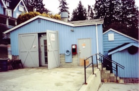
Buildings at New Haven
https://search.heritageburnaby.ca/link/museumdescription13536
- Repository
- Burnaby Village Museum
- Date
- Jan. 2001
- Collection/Fonds
- Burnaby Village Museum Photograph collection
- Description Level
- Item
- Physical Description
- 1 photograph : col. ; 5.3 x 10 cm
- Scope and Content
- Photograph of workshop and main house at New Haven Correctional Centre. The workshop has two large double doors with a concrete driveway in front.
- Repository
- Burnaby Village Museum
- Collection/Fonds
- Burnaby Village Museum Photograph collection
- Description Level
- Item
- Physical Description
- 1 photograph : col. ; 5.3 x 10 cm
- Scope and Content
- Photograph of workshop and main house at New Haven Correctional Centre. The workshop has two large double doors with a concrete driveway in front.
- History
- In 1937 New Haven Correctional Centre was established as the British Columbia Training School on the southeast side of Marine Drive in Burnaby (4250 Marine Drive). Sections of Sussex and Patterson Avenues bordered the estate. Originally, the facility housed nineteen inmates with two staff and was one of the first initiatives in Canada to segregate young adult inmates into a separate institution apart from adults. This was part of the Borstal system that started in England whereby young male offenders between the ages of sixteen and twenty one were trained to earn an honest living. Alterations and additions to the estate took place between December 1937 and October 1939 so that more inmates could be accomodated. Five new cottages were built that could hold up to forty people. Except for the plastering and lighting, all work on the new cottages was done by the inmates. On October 29, 1939, the Lieutenant-Governor Eric Hamber formally opened the New Haven Borstal School. World War II interrupted full development of the intstitution and it was closed in 1941 when the inmates were were conscripted into the army. Between 1941 and 1947 the Deaf and Blind Institute were housed at New Haven. In 1947, the New Haven Borstal School returned to the estate. New additions were added to old buildings and new additional buildings were erected on the site over the years including a warden's house on the east grounds and a barn and gymnasium. In the 1970s an equipment shed was added along with another dormitory and a variety of small sheds and storage buildings. The correctional centre officially closed in March 2001.
- Subjects
- Public Services - Correctional
- Geographic Access
- Marine Drive
- Street Address
- 4250 Marine Drive
- Accession Code
- BV020.5.879
- Access Restriction
- No restrictions
- Reproduction Restriction
- No known restrictions
- Date
- Jan. 2001
- Media Type
- Photograph
- Historic Neighbourhood
- Fraser Arm (Historic Neighbourhood)
- Planning Study Area
- Suncrest Area
- Scan Resolution
- 600
- Scan Date
- 25-Aug-2020
- Scale
- 100
- Notes
- Title based on contents of photograph
- Photograph processing stamp on front of photograph reads: "'01_1_13"
- Historical information based on notes from Mary Forsyth's research notes "New Haven" MSS185-018
Images
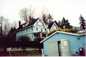
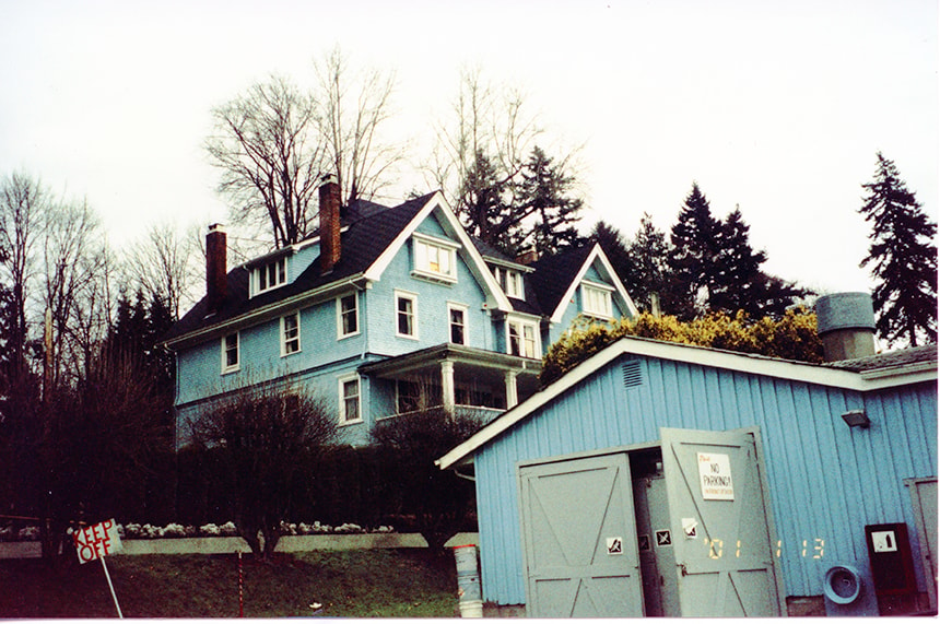
New Haven buildings
https://search.heritageburnaby.ca/link/museumdescription13527
- Repository
- Burnaby Village Museum
- Date
- Jan. 2001
- Collection/Fonds
- Burnaby Village Museum Photograph collection
- Description Level
- Item
- Physical Description
- 1 photograph : col. ; 5.3 x 10 cm
- Scope and Content
- Photograph of the main building and workshop building inside of New Haven Correctional Centre located on Marine Drive in Burnaby.
- Repository
- Burnaby Village Museum
- Collection/Fonds
- Burnaby Village Museum Photograph collection
- Description Level
- Item
- Physical Description
- 1 photograph : col. ; 5.3 x 10 cm
- Scope and Content
- Photograph of the main building and workshop building inside of New Haven Correctional Centre located on Marine Drive in Burnaby.
- History
- In 1937 New Haven Correctional Centre was established as the British Columbia Training School on the southeast side of Marine Drive in Burnaby (4250 Marine Drive). Sections of Sussex and Patterson Avenues bordered the estate. Originally, the facility housed nineteen inmates with two staff and was one of the first initiatives in Canada to segregate young adult inmates into a separate institution apart from adults. This was part of the Borstal system that started in England whereby young male offenders between the ages of sixteen and twenty one were trained to earn an honest living. Alterations and additions to the estate took place between December 1937 and October 1939 so that more inmates could be accomodated. Five new cottages were built that could hold up to forty people. Except for the plastering and lighting, all work on the new cottages was done by the inmates. On October 29, 1939, the Lieutenant-Governor Eric Hamber formally opened the New Haven Borstal School. World War II interrupted full development of the intstitution and it was closed in 1941 when the inmates were were conscripted into the army. Between 1941 and 1947 the Deaf and Blind Institute were housed at New Haven. In 1947, the New Haven Borstal School returned to the estate. New additions were added to old buildings and new additional buildings were erected on the site over the years including a warden's house on the east grounds and a barn and gymnasium. In the 1970s an equipment shed was added along with another dormitory and a variety of small sheds and storage buildings. The correctional centre officially closed in March 2001.
- Subjects
- Public Services - Correctional
- Geographic Access
- Marine Drive
- Street Address
- 4250 Marine Drive
- Accession Code
- BV020.5.871
- Access Restriction
- No restrictions
- Reproduction Restriction
- No known restrictions
- Date
- Jan. 2001
- Media Type
- Photograph
- Historic Neighbourhood
- Fraser Arm (Historic Neighbourhood)
- Planning Study Area
- Suncrest Area
- Scan Resolution
- 600
- Scan Date
- 25-Aug-2020
- Scale
- 100
- Notes
- Title based on contents of photograph
- Photograph processing stamp on front of photograph reads: "'01_1_13"
- Historical information based on notes from Mary Forsyth's research notes "New Haven" MSS185-018
Images
![Oakalla Prison Farm buildings and grounds, [198-] thumbnail](/media/hpo/_Data/_BVM_Images/1991/1991_0045_0505_001.jpg?width=280)
Oakalla Prison Farm buildings and grounds
https://search.heritageburnaby.ca/link/museumdescription3126
- Repository
- Burnaby Village Museum
- Date
- [198-]
- Collection/Fonds
- Oakalla Prison collection
- Description Level
- Item
- Physical Description
- 1 photograph : b&w negative ; 10 x 12.5 cm
- Scope and Content
- Photograph of the grounds and buildings of Oakalla Prison Farm looking north towards Deer Lake. An open field is visible in the foreground with a barn and other other farm buildings located down the slope towards the lake.
- Repository
- Burnaby Village Museum
- Collection/Fonds
- Oakalla Prison collection
- Description Level
- Item
- Physical Description
- 1 photograph : b&w negative ; 10 x 12.5 cm
- Scope and Content
- Photograph of the grounds and buildings of Oakalla Prison Farm looking north towards Deer Lake. An open field is visible in the foreground with a barn and other other farm buildings located down the slope towards the lake.
- History
- Salvaged from Oakalla Prison Farm site in October, 1991
- Subjects
- Public Services - Correctional
- Geographic Access
- Oakmount Crescent
- Street Address
- 5220 Oakmount Crescent
- Accession Code
- BV991.45.505
- Access Restriction
- No restrictions
- Reproduction Restriction
- May be restricted by third party rights
- Date
- [198-]
- Media Type
- Photograph
- Historic Neighbourhood
- Burnaby Lake (Historic Neighbourhood)
- Planning Study Area
- Oakalla Area
- Scan Resolution
- 1200
- Scan Date
- 2022-01-10
- Notes
- Title based on contents of photograph
Images
![Oakalla Prison Farm buildings and grounds, [198-] thumbnail](/media/hpo/_Data/_BVM_Images/1991/1991_0045_0505_001.jpg)
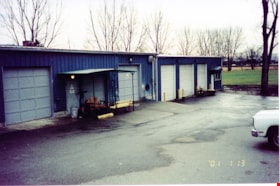
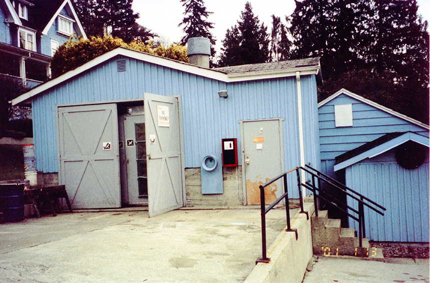
Workshop buildings at New Haven
https://search.heritageburnaby.ca/link/museumdescription13535
- Repository
- Burnaby Village Museum
- Date
- Jan. 2001
- Collection/Fonds
- Burnaby Village Museum Photograph collection
- Description Level
- Item
- Physical Description
- 1 photograph : col. ; 5.3 x 10 cm
- Scope and Content
- Photograph of workshop buildings with five bay doors at New Haven Correctional Centre.
- Repository
- Burnaby Village Museum
- Collection/Fonds
- Burnaby Village Museum Photograph collection
- Description Level
- Item
- Physical Description
- 1 photograph : col. ; 5.3 x 10 cm
- Scope and Content
- Photograph of workshop buildings with five bay doors at New Haven Correctional Centre.
- History
- In 1937 New Haven Correctional Centre was established as the British Columbia Training School on the southeast side of Marine Drive in Burnaby (4250 Marine Drive). Sections of Sussex and Patterson Avenues bordered the estate. Originally, the facility housed nineteen inmates with two staff and was one of the first initiatives in Canada to segregate young adult inmates into a separate institution apart from adults. This was part of the Borstal system that started in England whereby young male offenders between the ages of sixteen and twenty one were trained to earn an honest living. Alterations and additions to the estate took place between December 1937 and October 1939 so that more inmates could be accomodated. Five new cottages were built that could hold up to forty people. Except for the plastering and lighting, all work on the new cottages was done by the inmates. On October 29, 1939, the Lieutenant-Governor Eric Hamber formally opened the New Haven Borstal School. World War II interrupted full development of the intstitution and it was closed in 1941 when the inmates were were conscripted into the army. Between 1941 and 1947 the Deaf and Blind Institute were housed at New Haven. In 1947, the New Haven Borstal School returned to the estate. New additions were added to old buildings and new additional buildings were erected on the site over the years including a warden's house on the east grounds and a barn and gymnasium. In the 1970s an equipment shed was added along with another dormitory and a variety of small sheds and storage buildings. The correctional centre officially closed in March 2001.
- Subjects
- Public Services - Correctional
- Geographic Access
- Marine Drive
- Street Address
- 4250 Marine Drive
- Accession Code
- BV020.5.878
- Access Restriction
- No restrictions
- Reproduction Restriction
- No known restrictions
- Date
- Jan. 2001
- Media Type
- Photograph
- Historic Neighbourhood
- Fraser Arm (Historic Neighbourhood)
- Planning Study Area
- Suncrest Area
- Scan Resolution
- 600
- Scan Date
- 25-Aug-2020
- Scale
- 100
- Notes
- Title based on contents of photograph
- Photograph processing stamp on front of photograph reads: "'01_1_13"
- Historical information based on notes from Mary Forsyth's research notes "New Haven" MSS185-018
Images

![3700 block of Hastings Street, [2000] thumbnail](/media/hpo/_Data/_Archives_Images/_Unrestricted/535/535-3066.jpg?width=280)
3700 block of Hastings Street
https://search.heritageburnaby.ca/link/archivedescription97940
- Repository
- City of Burnaby Archives
- Date
- [2000]
- Collection/Fonds
- Burnaby NewsLeader photograph collection
- Description Level
- Item
- Physical Description
- 1 photograph (tiff) : b&w
- Scope and Content
- Photograph of the 3700 block of Hastings Street in North Burnaby, looking southeast. Kato Japanese Chinese Restaurant is one of the visible businesses and some snow is on the ground.
- Repository
- City of Burnaby Archives
- Date
- [2000]
- Collection/Fonds
- Burnaby NewsLeader photograph collection
- Physical Description
- 1 photograph (tiff) : b&w
- Description Level
- Item
- Record No.
- 535-3066
- Access Restriction
- No restrictions
- Reproduction Restriction
- No restrictions
- Accession Number
- 2018-12
- Scope and Content
- Photograph of the 3700 block of Hastings Street in North Burnaby, looking southeast. Kato Japanese Chinese Restaurant is one of the visible businesses and some snow is on the ground.
- Subjects
- Geographic Features - Roads
- Buildings - Commercial
- Buildings - Commercial - Restaurants
- Buildings - Residential
- Media Type
- Photograph
- Notes
- Title based on contents of photograph
- Collected by editorial for use in a January 2000 issue of the Burnaby NewsLeader
- Geographic Access
- Hastings Street
- Street Address
- 3700 Hastings Street
- Historic Neighbourhood
- Vancouver Heights (Historic Neighbourhood)
- Planning Study Area
- Burnaby Heights Area
Images
![3700 block of Hastings Street, [2000] thumbnail](/media/hpo/_Data/_Archives_Images/_Unrestricted/535/535-3066.jpg)
![Cranberry Commons, [2002] thumbnail](/media/hpo/_Data/_Archives_Images/_Unrestricted/535/535-2517-1.jpg?width=280)
Cranberry Commons
https://search.heritageburnaby.ca/link/archivedescription96962
- Repository
- City of Burnaby Archives
- Date
- [2002]
- Collection/Fonds
- Burnaby NewsLeader photograph collection
- Description Level
- File
- Physical Description
- 2 photographs (tiff) : b&w and col.
- Scope and Content
- File contains photographs of Ronaye Mathew at Cranberry Commons, a cohousing development in North Burnaby that received an Environment Award from the City of Burnaby. Photographs depict Mathew in the development's courtyard and posing in the communal kitchen.
- Repository
- City of Burnaby Archives
- Date
- [2002]
- Collection/Fonds
- Burnaby NewsLeader photograph collection
- Physical Description
- 2 photographs (tiff) : b&w and col.
- Description Level
- File
- Record No.
- 535-2517
- Access Restriction
- No restrictions
- Reproduction Restriction
- No restrictions
- Accession Number
- 2018-12
- Scope and Content
- File contains photographs of Ronaye Mathew at Cranberry Commons, a cohousing development in North Burnaby that received an Environment Award from the City of Burnaby. Photographs depict Mathew in the development's courtyard and posing in the communal kitchen.
- Subjects
- Buildings - Residential - Apartments
- Buildings - Residential
- Buildings - Residential - Townhouses
- Media Type
- Photograph
- Photographer
- Bartel, Mario
- Notes
- Title based on caption
- Collected by editorial for use in a June 2002 issue of the Burnaby NewsLeader
- Caption from metadata for 535-2517-1: "Ronaye Mathew relaxes in the central courtyard at Cranberry Commons, a cohousing development in North Burnaby that's been honoured by the city with an Environment Award."
- Caption from metadata for 535-2517-2: "Ronaye Mathew enjoys a rare moment of peace in the communal kitchen at Cranberry Commons, a cohousing development in North Burnaby. At least three times a week, the kitchen is crowded for communal dinners. The development has been honored by the City with an Environment Award."
- Geographic Access
- Albert Street
- Street Address
- 4272 Albert Street
- Historic Neighbourhood
- Vancouver Heights (Historic Neighbourhood)
- Planning Study Area
- Burnaby Heights Area
Images
![Cranberry Commons, [2002] thumbnail](/media/hpo/_Data/_Archives_Images/_Unrestricted/535/535-2517-1.jpg)

First School at Burnaby Lake
https://search.heritageburnaby.ca/link/archivedescription39549
- Repository
- City of Burnaby Archives
- Date
- 1909
- Collection/Fonds
- Peers Family and Hill Family fonds
- Description Level
- Item
- Physical Description
- 1 photograph : b&w ; 12.5 x 17 cm on page 21.5 x 28 cm (pasted in album)
- Scope and Content
- Photograph of Harriet Woodward and her class of students outside the Woodward home near Deer Lake which served as the first school and post office in the Burnaby Lake area; (l to r): Harriet Woodward (Miss Harry), Bob Peers, Melvin Mawhinney, Muriel Sprott, Kitty Hill, Beatrice Clayton and Arthur P…
- Repository
- City of Burnaby Archives
- Date
- 1909
- Collection/Fonds
- Peers Family and Hill Family fonds
- Physical Description
- 1 photograph : b&w ; 12.5 x 17 cm on page 21.5 x 28 cm (pasted in album)
- Description Level
- Item
- Record No.
- 477-868
- Access Restriction
- No restrictions
- Reproduction Restriction
- No known restrictions
- Accession Number
- 2007-12
- Scope and Content
- Photograph of Harriet Woodward and her class of students outside the Woodward home near Deer Lake which served as the first school and post office in the Burnaby Lake area; (l to r): Harriet Woodward (Miss Harry), Bob Peers, Melvin Mawhinney, Muriel Sprott, Kitty Hill, Beatrice Clayton and Arthur Peers. The cottage was a prefabricated building designed by J.J. Mahoney and architect Joseph Bowman and was manufactured in Vancouver by the B.C. Mills Timber and Trading Company and erected here is 1904. The cottage was enlarged with several additions until 1912 when the Woodwards built a new house.
- Subjects
- Buildings - Residential - Houses
- Buildings - Public - Post Offices
- Buildings - Schools
- Occupations - Teachers
- Names
- Clayton, Beatrice
- Mawhinney, Melvin
- Peers, Arthur Francis "Mike"
- Peers, Katherine Maude Hill "Kitty"
- Peers, William John "Bob"
- Sprott, Muriel
- Woodward, Harriet
- Media Type
- Photograph
- Notes
- Title based on caption accompanying photograph
- Geographic Access
- Sperling Avenue
- Street Address
- 5141 Sperling Avenue
- Historic Neighbourhood
- Burnaby Lake (Historic Neighbourhood)
- Planning Study Area
- Morley-Buckingham Area
Images


Maude and Harriet Woodward Cottage
https://search.heritageburnaby.ca/link/archivedescription39571
- Repository
- City of Burnaby Archives
- Date
- 1904
- Collection/Fonds
- Peers Family and Hill Family fonds
- Description Level
- Item
- Physical Description
- 1 photograph : b&w ; 5 x 7.5 cm on page 21.5 x 28 cm (pasted in album)
- Scope and Content
- Photograph of an unidentified person sitting on the porch of the Maude and Harriet Woodward cottage. This house was a prefabricated cottage erected in 1904. The cottages were designed by J.J. Mahoney and architect Joseph Bowman and were manufactured in Vancouver by the B.C. Mills Timber and Tradi…
- Repository
- City of Burnaby Archives
- Date
- 1904
- Collection/Fonds
- Peers Family and Hill Family fonds
- Physical Description
- 1 photograph : b&w ; 5 x 7.5 cm on page 21.5 x 28 cm (pasted in album)
- Description Level
- Item
- Record No.
- 477-890
- Access Restriction
- No restrictions
- Reproduction Restriction
- No known restrictions
- Accession Number
- 2007-12
- Scope and Content
- Photograph of an unidentified person sitting on the porch of the Maude and Harriet Woodward cottage. This house was a prefabricated cottage erected in 1904. The cottages were designed by J.J. Mahoney and architect Joseph Bowman and were manufactured in Vancouver by the B.C. Mills Timber and Trading Company. Maude Woodward established a post-office here which was operated by her sister, Harriet. Harriet also began a small private school here, the first in Burnaby Lake. The cottage was enlarged with several additions until 1912 when the Woodwards built a new house.
- Media Type
- Photograph
- Notes
- Title based on contents of photograph
- Geographic Access
- Sperling Avenue
- Street Address
- 5141 Sperling Avenue
- Historic Neighbourhood
- Burnaby Lake (Historic Neighbourhood)
- Planning Study Area
- Morley-Buckingham Area
Images

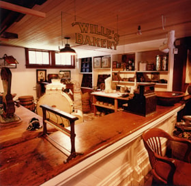
Willie's bakery
https://search.heritageburnaby.ca/link/museumdescription12951
- Repository
- Burnaby Village Museum
- Date
- 1984
- Collection/Fonds
- Century Park Museum Association fonds
- Description Level
- Item
- Physical Description
- 1 photograph : col. ; 12.5 x 12.5 cm
- Scope and Content
- Photograph of "Willie's Bakery" inside the Burnaby Village Museum General Store building. A long wooden counter divides the public from the work area. Shelving and work tables behind the counter hold various baking supplies and equipment.
- Repository
- Burnaby Village Museum
- Collection/Fonds
- Century Park Museum Association fonds
- Description Level
- Item
- Physical Description
- 1 photograph : col. ; 12.5 x 12.5 cm
- Scope and Content
- Photograph of "Willie's Bakery" inside the Burnaby Village Museum General Store building. A long wooden counter divides the public from the work area. Shelving and work tables behind the counter hold various baking supplies and equipment.
- Subjects
- Buildings - Commercial - General Stores
- Buildings - Commercial - Bakeries
- Buildings - Civic - Museums
- Names
- Burnaby Village Museum
- Accession Code
- BV020.5.666
- Access Restriction
- No restrictions
- Reproduction Restriction
- No known restrictions
- Date
- 1984
- Media Type
- Photograph
- Related Material
- See b&w photograph: BV020.5.699
- Scan Resolution
- 600
- Scan Date
- 9-Apr-20
- Scale
- 100
- Notes
- Title based on contents of photograph
Images

3051-75 Underhill Ave
https://search.heritageburnaby.ca/link/archivedescription93744
- Repository
- City of Burnaby Archives
- Date
- 1989
- Collection/Fonds
- Grover, Elliott & Co. Ltd. fonds
- Description Level
- File
- Physical Description
- 11 photographs : col. negatives ; 35 mm
- Scope and Content
- Photographs of two industrial buildings and a residential building in Burnaby, BC.
- Repository
- City of Burnaby Archives
- Date
- 1989
- Collection/Fonds
- Grover, Elliott & Co. Ltd. fonds
- Physical Description
- 11 photographs : col. negatives ; 35 mm
- Description Level
- File
- Record No.
- 622-029
- Access Restriction
- No restrictions
- Reproduction Restriction
- No restrictions
- Accession Number
- 2017-39
- Scope and Content
- Photographs of two industrial buildings and a residential building in Burnaby, BC.
- Media Type
- Photograph
- Notes
- Transcribed title
- Title transcribed from print envelope photographs were originally housed in
- File no. 89-394-B
- Geographic Access
- Underhill Avenue
- Planning Study Area
- Lake City Area
6622 Willingdon
https://search.heritageburnaby.ca/link/archivedescription93741
- Repository
- City of Burnaby Archives
- Date
- 1989
- Collection/Fonds
- Grover, Elliott & Co. Ltd. fonds
- Description Level
- File
- Physical Description
- 14 photographs : col. negatives ; 35 mm + 3 photographs : col. ; 10 cm x 15 cm
- Scope and Content
- Photographs of the exterior of a three-storey apartment complex located at 6622 Willingdon Avenue, an unidentified industrial complex (Norland), and Heywood Park Place.
- Repository
- City of Burnaby Archives
- Date
- 1989
- Collection/Fonds
- Grover, Elliott & Co. Ltd. fonds
- Physical Description
- 14 photographs : col. negatives ; 35 mm + 3 photographs : col. ; 10 cm x 15 cm
- Description Level
- File
- Record No.
- 622-026
- Access Restriction
- No restrictions
- Reproduction Restriction
- No restrictions
- Accession Number
- 2017-39
- Scope and Content
- Photographs of the exterior of a three-storey apartment complex located at 6622 Willingdon Avenue, an unidentified industrial complex (Norland), and Heywood Park Place.
- Media Type
- Photograph
- Notes
- Transcribed title
- Title transcribed from print envelope photographs were originally housed in
- File no. 89-235-B
- Photographs 622-026-15 : 622-026-17 depict 6622 Willingdon Avenue
- Geographic Access
- Willingdon Avenue
- Street Address
- 6622 Willingdon Avenue
- Historic Neighbourhood
- Central Park (Historic Neighbourhood)
- Planning Study Area
- Maywood Area
![Alan Emmott outside the Alan Emmott Centre, [2002] thumbnail](/media/hpo/_Data/_Archives_Images/_Unrestricted/535/535-2835.jpg?width=280)
Alan Emmott outside the Alan Emmott Centre
https://search.heritageburnaby.ca/link/archivedescription97496
- Repository
- City of Burnaby Archives
- Date
- [2002]
- Collection/Fonds
- Burnaby NewsLeader photograph collection
- Description Level
- Item
- Physical Description
- 1 photograph (tiff) : col.
- Scope and Content
- Photograph of Alan Emmott, former reeve and freeman of the City of Burnaby, posing with his arms outstretched outside of the new Alan Emmott Centre community hall, located in the restored former Burnaby South Secondary building, before its official opening.
- Repository
- City of Burnaby Archives
- Date
- [2002]
- Collection/Fonds
- Burnaby NewsLeader photograph collection
- Physical Description
- 1 photograph (tiff) : col.
- Description Level
- Item
- Record No.
- 535-2835
- Access Restriction
- No restrictions
- Reproduction Restriction
- No restrictions
- Accession Number
- 2018-12
- Scope and Content
- Photograph of Alan Emmott, former reeve and freeman of the City of Burnaby, posing with his arms outstretched outside of the new Alan Emmott Centre community hall, located in the restored former Burnaby South Secondary building, before its official opening.
- Subjects
- Officials - Mayors and Reeves
- Buildings - Recreational - Community Halls
- Buildings - Civic - Community Centres
- Names
- Emmott, Alan H.
- Media Type
- Photograph
- Photographer
- Bartel, Mario
- Notes
- Title based on caption
- Collected by editorial for use in a November 2002 issue of the Burnaby NewsLeader
- Caption from metadata: "Alan Emmott, a former mayor of Burnaby and now a Freeman of the City, welcomes visitors to the new community centre that bears his name. The Alan Emmott Centre, in the old Burnaby South Secondary building, officially opens on Saturday."
- Geographic Access
- Southoaks Crescent
- Street Address
- 6650 Southoaks Crescent
- Historic Neighbourhood
- Edmonds (Historic Neighbourhood)
- Planning Study Area
- Kingsway-Beresford Area
Images
![Alan Emmott outside the Alan Emmott Centre, [2002] thumbnail](/media/hpo/_Data/_Archives_Images/_Unrestricted/535/535-2835.jpg)
![Ann Greensill in Ming Wo, [2001] thumbnail](/media/hpo/_Data/_Archives_Images/_Unrestricted/535/535-2969.jpg?width=280)
Ann Greensill in Ming Wo
https://search.heritageburnaby.ca/link/archivedescription97686
- Repository
- City of Burnaby Archives
- Date
- [2001]
- Collection/Fonds
- Burnaby NewsLeader photograph collection
- Description Level
- Item
- Physical Description
- 1 photograph (tiff) : col.
- Scope and Content
- Photograph of Ann Greensill, the manager of Ming Wo Cookware in Lougheed Mall, holding up three Cuisipro whisks.
- Repository
- City of Burnaby Archives
- Date
- [2001]
- Collection/Fonds
- Burnaby NewsLeader photograph collection
- Physical Description
- 1 photograph (tiff) : col.
- Description Level
- Item
- Record No.
- 535-2969
- Access Restriction
- No restrictions
- Reproduction Restriction
- No restrictions
- Accession Number
- 2018-12
- Scope and Content
- Photograph of Ann Greensill, the manager of Ming Wo Cookware in Lougheed Mall, holding up three Cuisipro whisks.
- Names
- Lougheed Town Centre
- Media Type
- Photograph
- Photographer
- Bartel, Mario
- Notes
- Title based on caption
- Collected by editorial for use in a December 2001 issue of the Burnaby NewsLeader
- Caption from metadata: "Ann Greensill, the manager of Ming Wo in Lougheed Mall, shows off a set of Cuisipro whisks, made of heat-resistant silicon and soft enough to be used in non-stick pans."
- Geographic Access
- Austin Road
- Lougheed Highway
- Street Address
- 9855 Austin Avenue
- Historic Neighbourhood
- Burquitlam (Historic Neighbourhood)
- Planning Study Area
- Cameron Area
Images
![Ann Greensill in Ming Wo, [2001] thumbnail](/media/hpo/_Data/_Archives_Images/_Unrestricted/535/535-2969.jpg)
![Baldwin House, [2002] thumbnail](/media/hpo/_Data/_Archives_Images/_Unrestricted/535/535-2830-2.jpg?width=280)
Baldwin House
https://search.heritageburnaby.ca/link/archivedescription97491
- Repository
- City of Burnaby Archives
- Date
- [2002]
- Collection/Fonds
- Burnaby NewsLeader photograph collection
- Description Level
- File
- Physical Description
- 4 photographs (tiff) : col.
- Scope and Content
- File contains of photographs of Baldwin House on Deer Lake, the home designed for the Baldwins by Arthur Erickson, prior to its heritage designation by the City of Burnaby. Photographs depict Ruth Baldwin posing on the house's deck by Deer Lake; an exterior view of the home; the home's dock; and a …
- Repository
- City of Burnaby Archives
- Date
- [2002]
- Collection/Fonds
- Burnaby NewsLeader photograph collection
- Physical Description
- 4 photographs (tiff) : col.
- Description Level
- File
- Record No.
- 535-2830
- Access Restriction
- No restrictions
- Reproduction Restriction
- No restrictions
- Accession Number
- 2018-12
- Scope and Content
- File contains of photographs of Baldwin House on Deer Lake, the home designed for the Baldwins by Arthur Erickson, prior to its heritage designation by the City of Burnaby. Photographs depict Ruth Baldwin posing on the house's deck by Deer Lake; an exterior view of the home; the home's dock; and a view of the interior living room with its original drapes and Scandinavian furniture.
- Subjects
- Buildings - Heritage
- Buildings - Residential - Houses
- Geographic Features - Lakes and Ponds
- Names
- Baldwin, Ruth
- Media Type
- Photograph
- Photographer
- Bartel, Mario
- Notes
- Title based on caption
- Collected by editorial for use in an October 2002 issue of the Burnaby NewsLeader
- Caption from metadata for 535-2830-1: "Ruth Baldwin enjoys the view of Deer Lake from the lower level of the house designed for her and her husband by Arthur Erickson, an old school chum. The house is now owned by the City of Burnaby, which wants to give it a heritage designation."
- Caption from metadata for 535-2830-2: "Architect Arthur Erickson designed Baldwin House to complement its surroundings, on the southern shore of Deer Lake. But there were technical challenges, like supporting the house in the swampy soil."
- Caption from metadata for 535-2830-4: "The living room of Baldwin House is like a time capsule to the 1960's, with the original drapes and contemporary Scandanavian furniture that was in style at the time."
- Geographic Access
- Deer Lake Drive
- Deer Lake
- Street Address
- 6543 Deer Lake Drive
- Historic Neighbourhood
- Burnaby Lake (Historic Neighbourhood)
- Planning Study Area
- Morley-Buckingham Area
Images
![Baldwin House, [2002] thumbnail](/media/hpo/_Data/_Archives_Images/_Unrestricted/535/535-2830-2.jpg)
![Burnaby Art Gallery, [1980] thumbnail](/media/hpo/_Data/_Archives_Images/_Unrestricted/316/349-002.jpg?width=280)
Burnaby Art Gallery
https://search.heritageburnaby.ca/link/archivedescription37306
- Repository
- City of Burnaby Archives
- Date
- [1980]
- Collection/Fonds
- Burnaby Historical Society fonds
- Description Level
- Item
- Physical Description
- 1 photograph : b&w ; 10 x 15 cm
- Scope and Content
- Photograph of the exterior of the Burnaby Art Gallery and parking lot. This building was formerly the H. Ceperley family's Fairacres estate, built in 1911.
- Repository
- City of Burnaby Archives
- Date
- [1980]
- Collection/Fonds
- Burnaby Historical Society fonds
- Subseries
- Jim Wolf subseries
- Physical Description
- 1 photograph : b&w ; 10 x 15 cm
- Description Level
- Item
- Record No.
- 349-002
- Access Restriction
- No restrictions
- Reproduction Restriction
- Reproduce for fair dealing purposes only
- Accession Number
- BHS1997-09
- Scope and Content
- Photograph of the exterior of the Burnaby Art Gallery and parking lot. This building was formerly the H. Ceperley family's Fairacres estate, built in 1911.
- Names
- Burnaby Art Gallery
- Media Type
- Photograph
- Photographer
- Houghtaling, Kim
- Notes
- Title based on contents of photograph
- Geographic Access
- Deer Lake Avenue
- Street Address
- 6344 Deer Lake Avenue
- Historic Neighbourhood
- Burnaby Lake (Historic Neighbourhood)
- Planning Study Area
- Douglas-Gilpin Area
Images
![Burnaby Art Gallery, [1980] thumbnail](/media/hpo/_Data/_Archives_Images/_Unrestricted/316/349-002.jpg)
![Camping out for new Star Wars, [2002] thumbnail](/media/hpo/_Data/_Archives_Images/_Unrestricted/535/535-2353.jpg?width=280)
Camping out for new Star Wars
https://search.heritageburnaby.ca/link/archivedescription96795
- Repository
- City of Burnaby Archives
- Date
- [2002]
- Collection/Fonds
- Burnaby NewsLeader photograph collection
- Description Level
- Item
- Physical Description
- 1 photograph (tiff) : col.
- Scope and Content
- Photograph of Hanson Lok, Brent Morning-Smith, Stephen Lee, and Iku Yeh in line for the new Star Wars movie at Metropolis. They are camping out in a tent and have plastic light sabers.
- Repository
- City of Burnaby Archives
- Date
- [2002]
- Collection/Fonds
- Burnaby NewsLeader photograph collection
- Physical Description
- 1 photograph (tiff) : col.
- Description Level
- Item
- Record No.
- 535-2353
- Access Restriction
- No restrictions
- Reproduction Restriction
- No restrictions
- Accession Number
- 2018-12
- Scope and Content
- Photograph of Hanson Lok, Brent Morning-Smith, Stephen Lee, and Iku Yeh in line for the new Star Wars movie at Metropolis. They are camping out in a tent and have plastic light sabers.
- Names
- Metrotown
- Media Type
- Photograph
- Photographer
- Bartel, Mario
- Notes
- Title based on caption
- Collected by editorial for use in a May 2002 issue of the Burnaby NewsLeader
- Caption from metadata: "Hanson Lok, Brent Morning-Smith, Stephen Lee and Iku Yeh make sure the force will be with them to get prime seats for the premiere of the latest Star Wars movie, early Thursday morning. They started camping out in front of Metropolis on Monday afternoon."
- Geographic Access
- Kingsway
- Street Address
- 4700 Kingsway
- Historic Neighbourhood
- Central Park (Historic Neighbourhood)
- Planning Study Area
- Maywood Area
Images
![Camping out for new Star Wars, [2002] thumbnail](/media/hpo/_Data/_Archives_Images/_Unrestricted/535/535-2353.jpg)
![Central Park pool, [2001] thumbnail](/media/hpo/_Data/_Archives_Images/_Unrestricted/535/535-2722.jpg?width=280)
Central Park pool
https://search.heritageburnaby.ca/link/archivedescription97331
- Repository
- City of Burnaby Archives
- Date
- [2001]
- Collection/Fonds
- Burnaby NewsLeader photograph collection
- Description Level
- Item
- Physical Description
- 1 photograph (tiff) : col.
- Scope and Content
- Photograph of lifeguard Janine Smith cleaning the empty Central Park outdoor pool in the rain.
- Repository
- City of Burnaby Archives
- Date
- [2001]
- Collection/Fonds
- Burnaby NewsLeader photograph collection
- Physical Description
- 1 photograph (tiff) : col.
- Description Level
- Item
- Record No.
- 535-2722
- Access Restriction
- No restrictions
- Reproduction Restriction
- No restrictions
- Accession Number
- 2018-12
- Scope and Content
- Photograph of lifeguard Janine Smith cleaning the empty Central Park outdoor pool in the rain.
- Subjects
- Buildings - Recreational - Swimming Pools
- Buildings - Recreational - Outdoor Swimming Pools
- Names
- Central Park
- Media Type
- Photograph
- Photographer
- Bartel, Mario
- Notes
- Title based on caption
- Collected by editorial for use in an August 2001 issue of the Burnaby NewsLeader
- Caption from metadata: "Janine Smith cleans the pool at Central Park in the middle of another shower Thursday morning. All the rain this week has made her lifeguarding duties kinda lonely. "There's no people," she says. "But the algae keeps coming.""
- Geographic Access
- Central Park
- Imperial Street
- Street Address
- 3883 Imperial Street
- Historic Neighbourhood
- Central Park (Historic Neighbourhood)
- Planning Study Area
- Maywood Area
Images
![Central Park pool, [2001] thumbnail](/media/hpo/_Data/_Archives_Images/_Unrestricted/535/535-2722.jpg)
![Commercial realtor Scott Brown, [2002] thumbnail](/media/hpo/_Data/_Archives_Images/_Unrestricted/535/535-1970.jpg?width=280)
Commercial realtor Scott Brown
https://search.heritageburnaby.ca/link/archivedescription96287
- Repository
- City of Burnaby Archives
- Date
- [2002]
- Collection/Fonds
- Burnaby NewsLeader photograph collection
- Description Level
- Item
- Physical Description
- 1 photograph (tiff) : col.
- Scope and Content
- Photograph of commercial real estate broker Scott Brown. Brown is standing in front of the Madison Centre on Lougheed Highway with his arms wide open. A sign in the window of the office tower reads: "For Lease."
- Repository
- City of Burnaby Archives
- Date
- [2002]
- Collection/Fonds
- Burnaby NewsLeader photograph collection
- Physical Description
- 1 photograph (tiff) : col.
- Description Level
- Item
- Record No.
- 535-1970
- Access Restriction
- No restrictions
- Reproduction Restriction
- No restrictions
- Accession Number
- 2018-12
- Scope and Content
- Photograph of commercial real estate broker Scott Brown. Brown is standing in front of the Madison Centre on Lougheed Highway with his arms wide open. A sign in the window of the office tower reads: "For Lease."
- Media Type
- Photograph
- Photographer
- Bartel, Mario
- Notes
- Title based on caption
- Collected by editorial for use in a February 2002 issue of the Burnaby NewsLeader
- Caption from metadata: "Scott Brown, a commercial real estate broker, says things are looking up for businesses looking for office space in Burnaby, as new space in buildings like the Madison Centre have increased the vacancy rates."
- Geographic Access
- Lougheed Highway
- Planning Study Area
- Brentwood Area
Images
![Commercial realtor Scott Brown, [2002] thumbnail](/media/hpo/_Data/_Archives_Images/_Unrestricted/535/535-1970.jpg)
![Community Centred College for the Retired, [2003] thumbnail](/media/hpo/_Data/_Archives_Images/_Unrestricted/535/535-2031-1.jpg?width=280)
Community Centred College for the Retired
https://search.heritageburnaby.ca/link/archivedescription96350
- Repository
- City of Burnaby Archives
- Date
- [2003]
- Collection/Fonds
- Burnaby NewsLeader photograph collection
- Description Level
- File
- Physical Description
- 2 photographs (tiff) : col.
- Scope and Content
- File contains photographs of the Community Centred College for the Retired just before the grand opening of its home at the Alan Emmott Centre. Photographs depict Mac Robinson, Delphine Lupis, Babe Diwell, and Pat Wilson in an organ class, and Krystyna Clarke viewing a schedule board with an uniden…
- Repository
- City of Burnaby Archives
- Date
- [2003]
- Collection/Fonds
- Burnaby NewsLeader photograph collection
- Physical Description
- 2 photographs (tiff) : col.
- Description Level
- File
- Record No.
- 535-2031
- Access Restriction
- No restrictions
- Reproduction Restriction
- No restrictions
- Accession Number
- 2018-12
- Scope and Content
- File contains photographs of the Community Centred College for the Retired just before the grand opening of its home at the Alan Emmott Centre. Photographs depict Mac Robinson, Delphine Lupis, Babe Diwell, and Pat Wilson in an organ class, and Krystyna Clarke viewing a schedule board with an unidentified man seated in the background.
- Subjects
- Persons - Seniors
- Buildings - Civic - Community Centres
- Buildings - Civic - Seniors Centres
- Media Type
- Photograph
- Photographer
- Bartel, Mario
- Notes
- Title based on caption
- Collected by editorial for use in a February 2003 issue of the Burnaby NewsLeader
- Caption from metadata for 535-2031-1: "Mac Robinson, Delphine Lupis and Babe Diwell enjoy Pat Wilson's (standing) organ class, at the Community College for the Retired. The College will celebrate its 30th anniversary next Friday by officially opening their new home in the Alan Emmett [sic] Centre."
- Caption from metadata for 535-2031-2: "Krystyna Clarke checks the schedule board at the Community College for the Retired. The College will be celebrating its 30th anniversary next Friday with the grand opening of its new home in the Alan Emmett [sic] Centre."
Images
![Community Centred College for the Retired, [2003] thumbnail](/media/hpo/_Data/_Archives_Images/_Unrestricted/535/535-2031-1.jpg)
![Condominiums, [2000] thumbnail](/media/hpo/_Data/_Archives_Images/_Unrestricted/535/535-2869-1.jpg?width=280)
Condominiums
https://search.heritageburnaby.ca/link/archivedescription97530
- Repository
- City of Burnaby Archives
- Date
- [2000]
- Collection/Fonds
- Burnaby NewsLeader photograph collection
- Description Level
- File
- Physical Description
- 2 photographs (tiff) : col.
- Scope and Content
- File contains photographs of two condominium buildings. One building has a sign that reads: "Final Sell Out," and towers are visible behind the complex in the other photograph.
- Repository
- City of Burnaby Archives
- Date
- [2000]
- Collection/Fonds
- Burnaby NewsLeader photograph collection
- Physical Description
- 2 photographs (tiff) : col.
- Description Level
- File
- Record No.
- 535-2869
- Access Restriction
- No restrictions
- Reproduction Restriction
- No restrictions
- Accession Number
- 2018-12
- Scope and Content
- File contains photographs of two condominium buildings. One building has a sign that reads: "Final Sell Out," and towers are visible behind the complex in the other photograph.
- Subjects
- Buildings - Residential - Condominiums
- Buildings - Residential
- Advertising Medium - Signs and Signboards
- Media Type
- Photograph
- Notes
- Title based on contents of file
- Collected by editorial for use in an October 2000 issue of the Burnaby NewsLeader
Images
![Condominiums, [2000] thumbnail](/media/hpo/_Data/_Archives_Images/_Unrestricted/535/535-2869-1.jpg)