Narrow Results By
Subject
- Advertising Medium - Signs and Signboards 9
- Agricultural Tools and Equipment 1
- Agricultural Tools and Equipment - Plows 3
- Agriculture - Crops 5
- Agriculture - Farms 18
- Agriculture - Fruit and Berries 8
- Animals - Birds 1
- Animals - Cats 4
- Animals - Cows 1
- Animals - Dogs 14
- Animals - Fowl 1
- Animals - Horses 6
Creator
- Barrowclough, G.A. 1
- Bateman, Caroline Mary Wettenhall 1
- BC Photo Card Company 1
- Bingham, Alfred "Alf" 1
- Bolton, Richard 1
- Brown, William Thomas 2
- Burnaby Art Gallery 1
- Burnaby Public Library 1
- Burnett and McGugan B.C. Land Surveyors, New Westminster 5
- Burnett, Geoffrey K. 3
- Burnett & McGugan, Engineers and Surveyors 21
- Buxton, George Searby 1

Edmonds Triangle Block
https://search.heritageburnaby.ca/link/archivedescription38508
- Repository
- City of Burnaby Archives
- Date
- 1911
- Collection/Fonds
- Burnaby Historical Society fonds
- Description Level
- Item
- Physical Description
- 1 photograph: b&w postcard ; 8.5 x 14 cm
- Scope and Content
- Photographic postcard of the "triangle block" at Kingsway and Edmonds. The building housed stores, the post office, and Doctor Watson's apartment. Although the postcard bears no postmark, a note is written on the reverse which reads: "This is the new store at Edmonds. The shop at the end (before…
- Repository
- City of Burnaby Archives
- Date
- 1911
- Collection/Fonds
- Burnaby Historical Society fonds
- Subseries
- Photographs subseries
- Physical Description
- 1 photograph: b&w postcard ; 8.5 x 14 cm
- Description Level
- Item
- Record No.
- 449-003
- Access Restriction
- No restrictions
- Reproduction Restriction
- No known restrictions
- Accession Number
- BHS2007-04
- Scope and Content
- Photographic postcard of the "triangle block" at Kingsway and Edmonds. The building housed stores, the post office, and Doctor Watson's apartment. Although the postcard bears no postmark, a note is written on the reverse which reads: "This is the new store at Edmonds. The shop at the end (before it was opened) where the man is outside is the Post Office. Round the other side is a cafe, and upstairs we a Doctor living." A sign on the building reads "Edmonds General Store Co." and three unidentified people can be seen standing on the steps. In the foreground, the streetcar lines can be seen.
- Media Type
- Photograph
- Notes
- Title based on contents of photograph
- Geographic Access
- Edmonds Street
- Kingsway
- Street Address
- 7338 Kingsway
- Historic Neighbourhood
- Edmonds (Historic Neighbourhood)
- Planning Study Area
- Edmonds Area
Images


Edmonds Triangle Block
https://search.heritageburnaby.ca/link/archivedescription38511
- Repository
- City of Burnaby Archives
- Date
- 1911
- Collection/Fonds
- Burnaby Historical Society fonds
- Description Level
- Item
- Physical Description
- 1 photograph: b&w postcard ; 8.5 x 14 cm
- Scope and Content
- Photographic postcard of a car driving across the railway crossing in front of the Edmonds Block at Edmonds and Kingsway. The building on this block housed a store, a doctor's office, and a post office. Visible in this picture are the interurban tracks and Dr. Watson's apartment. The postcard be…
- Repository
- City of Burnaby Archives
- Date
- 1911
- Collection/Fonds
- Burnaby Historical Society fonds
- Subseries
- Photographs subseries
- Physical Description
- 1 photograph: b&w postcard ; 8.5 x 14 cm
- Description Level
- Item
- Record No.
- 449-006
- Access Restriction
- No restrictions
- Reproduction Restriction
- No known restrictions
- Accession Number
- BHS2007-04
- Scope and Content
- Photographic postcard of a car driving across the railway crossing in front of the Edmonds Block at Edmonds and Kingsway. The building on this block housed a store, a doctor's office, and a post office. Visible in this picture are the interurban tracks and Dr. Watson's apartment. The postcard bears a postmark dated October 19, 1911 and a note written by Dr. Watson to a Miss Watson, of Cheshire, England. The note reads: "This is a picture of our block. We occupy the rooms on the left side of the first floor including the end one facing which is one of the windows in my waiting room. The entrance is seen to the right. The photo has been taken from Edmonds Station. Both car lines run into New Westminster, that on the right is the most direct one. The one on the left goes round via East Burnaby and at present its terminus is below our window. Your letter of the 14th [illegible] will answer more fully soon. We are well. So sorry to hear of that terrible motor accident. Yours, G."
- Media Type
- Photograph
- Geographic Access
- Edmonds Street
- Kingsway
- Street Address
- 7338 Kingsway
- Historic Neighbourhood
- Edmonds (Historic Neighbourhood)
- Planning Study Area
- Edmonds Area
Images

![Esmond and Hastings Vicinity, [1915] (date of original), copied 1986 thumbnail](/media/hpo/_Data/_Archives_Images/_Unrestricted/204/204-306.jpg?width=280)
Esmond and Hastings Vicinity
https://search.heritageburnaby.ca/link/archivedescription35448
- Repository
- City of Burnaby Archives
- Date
- [1915] (date of original), copied 1986
- Collection/Fonds
- Burnaby Historical Society fonds
- Description Level
- Item
- Physical Description
- 1 photograph : b&w ; 12.7 x 17.8 cm print
- Scope and Content
- Photograph of the Arthur Wall Block (right), 3722 Hastings Street, at the corner of Hastings Street and Boundary Road, and the Matheson Block (left), 3730 Hastings Street. The British Columbia Electric Railway (BCER) Hastings car can be seen.
- Repository
- City of Burnaby Archives
- Date
- [1915] (date of original), copied 1986
- Collection/Fonds
- Burnaby Historical Society fonds
- Subseries
- Pioneer Tales subseries
- Physical Description
- 1 photograph : b&w ; 12.7 x 17.8 cm print
- Description Level
- Item
- Record No.
- 204-306
- Access Restriction
- No restrictions
- Reproduction Restriction
- No restrictions
- Accession Number
- BHS1988-03
- Scope and Content
- Photograph of the Arthur Wall Block (right), 3722 Hastings Street, at the corner of Hastings Street and Boundary Road, and the Matheson Block (left), 3730 Hastings Street. The British Columbia Electric Railway (BCER) Hastings car can be seen.
- Media Type
- Photograph
- Photographer
- Eaton, Dr. Carl
- Notes
- Title based on contents of photograph
- Geographic Access
- Hastings Street
- Street Address
- 3722 Hastings Street
- 3730 Hastings Street
- Historic Neighbourhood
- Vancouver Heights (Historic Neighbourhood)
- Planning Study Area
- Willingdon Heights Area
Images
![Esmond and Hastings Vicinity, [1915] (date of original), copied 1986 thumbnail](/media/hpo/_Data/_Archives_Images/_Unrestricted/204/204-306.jpg)
![Fairacres, [1913] thumbnail](/media/hpo/_Data/_Archives_Images/_Unrestricted/205/241-011.jpg?width=280)
Fairacres
https://search.heritageburnaby.ca/link/archivedescription36233
- Repository
- City of Burnaby Archives
- Date
- [1913]
- Collection/Fonds
- Burnaby Historical Society fonds
- Description Level
- Item
- Physical Description
- 1 photograph : b&w copy negative ; 4.5 x 8 cm
- Scope and Content
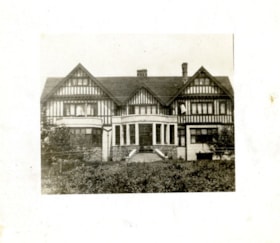
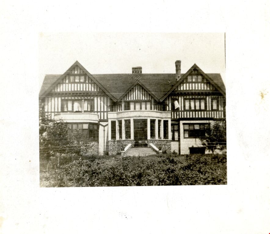
- Photograph of the Fairacres Mansion and its surrounding grounds.
- Repository
- City of Burnaby Archives
- Date
- [1913]
- Collection/Fonds
- Burnaby Historical Society fonds
- Subseries
- Burnaby Art Gallery subseries
- Physical Description
- 1 photograph : b&w copy negative ; 4.5 x 8 cm
- Description Level
- Item
- Record No.
- 241-011
- Access Restriction
- No restrictions
- Reproduction Restriction
- No known restrictions
- Accession Number
- BHS1990-05
- Scope and Content
- Photograph of the Fairacres Mansion and its surrounding grounds.
- Media Type
- Photograph
- Notes
- Title based on contents of photograph 1 b&w copy print accompanying
- Geographic Access
- Deer Lake Avenue
- Street Address
- 6344 Deer Lake Avenue
- Historic Neighbourhood
- Burnaby Lake (Historic Neighbourhood)
- Planning Study Area
- Douglas-Gilpin Area
Images
![Fairacres, [1913] thumbnail](/media/hpo/_Data/_Archives_Images/_Unrestricted/205/241-011.jpg)
![Fairacres Estate, [1913] thumbnail](/media/hpo/_Data/_Archives_Images/_Unrestricted/205/241-008.jpg?width=280)
Fairacres Estate
https://search.heritageburnaby.ca/link/archivedescription36230
- Repository
- City of Burnaby Archives
- Date
- [1913]
- Collection/Fonds
- Burnaby Historical Society fonds
- Description Level
- Item
- Physical Description
- 1 photograph : b&w copy negative ; 4.5 x 8 cm
- Scope and Content
- Photograph of the Fairacres' Estate, including the Mansion, a well groomed garden and a foot path winding through the lawn. Two men, a woman and three young children can be seen standing near the foot path, a few feet from the river's edge. One man is standing next to them on a small bridge that cr…
- Repository
- City of Burnaby Archives
- Date
- [1913]
- Collection/Fonds
- Burnaby Historical Society fonds
- Subseries
- Burnaby Art Gallery subseries
- Physical Description
- 1 photograph : b&w copy negative ; 4.5 x 8 cm
- Description Level
- Item
- Record No.
- 241-008
- Access Restriction
- No restrictions
- Reproduction Restriction
- No known restrictions
- Accession Number
- BHS1990-05
- Scope and Content
- Photograph of the Fairacres' Estate, including the Mansion, a well groomed garden and a foot path winding through the lawn. Two men, a woman and three young children can be seen standing near the foot path, a few feet from the river's edge. One man is standing next to them on a small bridge that crosses an ornamental pond, holding on to the bridge's wooden railing.
- Media Type
- Photograph
- Notes
- Title based on contents of photograph 1 b&w copy print accompanying
- Geographic Access
- Deer Lake Avenue
- Street Address
- 6344 Deer Lake Avenue
- Historic Neighbourhood
- Burnaby Lake (Historic Neighbourhood)
- Planning Study Area
- Douglas-Gilpin Area
Images
![Fairacres Estate, [1913] thumbnail](/media/hpo/_Data/_Archives_Images/_Unrestricted/205/241-008.jpg)
![Fairacres Gazebo and Mansion, [1914] thumbnail](/media/hpo/_Data/_Archives_Images/_Unrestricted/205/241-024.jpg?width=280)
Fairacres Gazebo and Mansion
https://search.heritageburnaby.ca/link/archivedescription36246
- Repository
- City of Burnaby Archives
- Date
- [1914]
- Collection/Fonds
- Burnaby Historical Society fonds
- Description Level
- Item
- Physical Description
- 1 photograph : b&w copy negative ; 7 x 10.5 cm
- Scope and Content
- Photograph of the Fairacres Gazebo and Mansion covered in snow.
- Repository
- City of Burnaby Archives
- Date
- [1914]
- Collection/Fonds
- Burnaby Historical Society fonds
- Subseries
- Burnaby Art Gallery subseries
- Physical Description
- 1 photograph : b&w copy negative ; 7 x 10.5 cm
- Description Level
- Item
- Record No.
- 241-024
- Access Restriction
- No restrictions
- Reproduction Restriction
- No known restrictions
- Accession Number
- BHS1990-05
- Scope and Content
- Photograph of the Fairacres Gazebo and Mansion covered in snow.
- Media Type
- Photograph
- Notes
- Title based on contents of photograph 1 b&w copy print accompanying
- Geographic Access
- Deer Lake Avenue
- Street Address
- 6344 Deer Lake Avenue
- Historic Neighbourhood
- Burnaby Lake (Historic Neighbourhood)
- Planning Study Area
- Douglas-Gilpin Area
Images
![Fairacres Gazebo and Mansion, [1914] thumbnail](/media/hpo/_Data/_Archives_Images/_Unrestricted/205/241-024.jpg)

Family at Fairacres
https://search.heritageburnaby.ca/link/archivedescription36231
- Repository
- City of Burnaby Archives
- Date
- 1915
- Collection/Fonds
- Burnaby Historical Society fonds
- Description Level
- Item
- Physical Description
- 1 photograph : b&w copy negative ; 4.5 x 8 cm
- Scope and Content
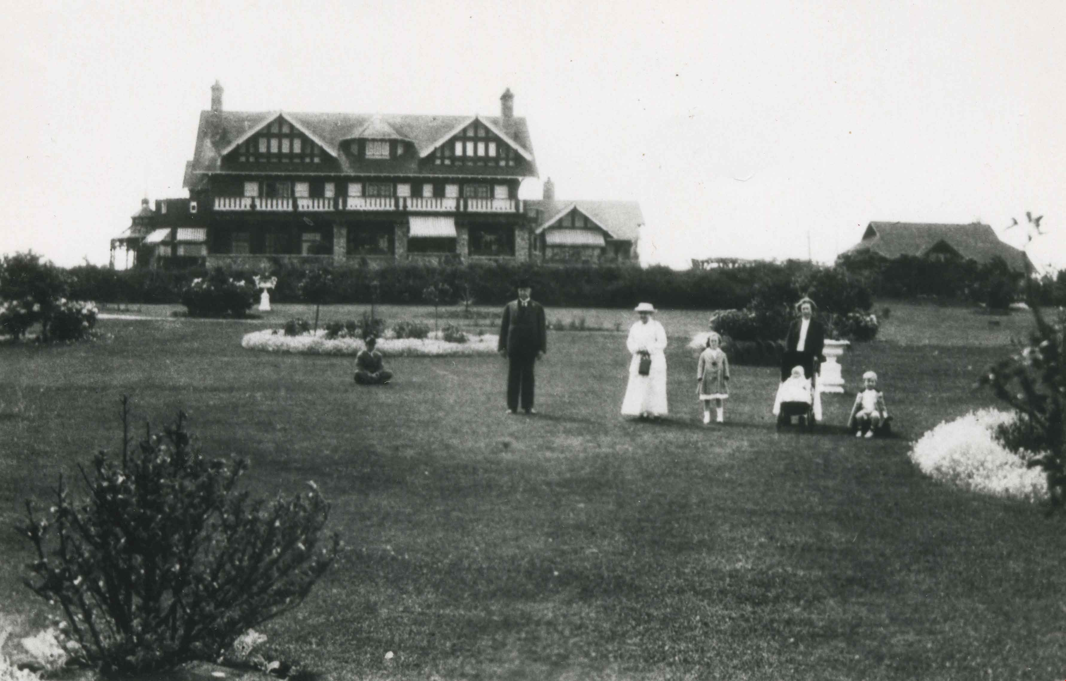
- Photograph of Fairacres Mansion, which later became the site of the Burnaby Art Gallery. The mansion was built in 1911 by Grace and Henry T. Ceperley as their retirement home. Three generations of the Ceperley family can be seen on the lawn; H.T. Ceperley, Grace Ceperley and their daughter Ethelwy…
- Repository
- City of Burnaby Archives
- Date
- 1915
- Collection/Fonds
- Burnaby Historical Society fonds
- Subseries
- Burnaby Art Gallery subseries
- Physical Description
- 1 photograph : b&w copy negative ; 4.5 x 8 cm
- Description Level
- Item
- Record No.
- 241-009
- Access Restriction
- No restrictions
- Reproduction Restriction
- No known restrictions
- Accession Number
- BHS1990-05
- Scope and Content
- Photograph of Fairacres Mansion, which later became the site of the Burnaby Art Gallery. The mansion was built in 1911 by Grace and Henry T. Ceperley as their retirement home. Three generations of the Ceperley family can be seen on the lawn; H.T. Ceperley, Grace Ceperley and their daughter Ethelwyn standing and Ethelwyn's three children; Edith Ceperley (standing), James Edward "Junior" (sitting) and Florence Renn (in carriage).The man seen seated on the left in the photograph could be James Edward Hall (Ethelwyn's husband).
- Media Type
- Photograph
- Notes
- Title based on contents of photograph 1 b&w copy print accompanying
- Geographic Access
- Deer Lake Avenue
- Street Address
- 6344 Deer Lake Avenue
- Historic Neighbourhood
- Burnaby Lake (Historic Neighbourhood)
- Planning Study Area
- Douglas-Gilpin Area
Images
![George Searby Buxton in front of house, [1911] (date of original), digitized 2010 thumbnail](/media/hpo/_Data/_Archives_Images/_Unrestricted/513/513-002.JPG?width=280)
George Searby Buxton in front of house
https://search.heritageburnaby.ca/link/archivedescription64600
- Repository
- City of Burnaby Archives
- Date
- [1911] (date of original), digitized 2010
- Collection/Fonds
- Buxton Family collection
- Description Level
- Item
- Physical Description
- 1 photograph (jpeg) : sepia ; 96 dpi
- Scope and Content
- Photograph of Burnaby pioneer George Searby Buxton in front of the house he was building in Burnaby. George Buxton was born in England and was a carpenter by trade. He and his wife Mary Isabel (nee Nattriss) moved to Canada between 1911 and 1913 and had five children: Clara Violet (1910-1913), Ma…
- Repository
- City of Burnaby Archives
- Date
- [1911] (date of original), digitized 2010
- Collection/Fonds
- Buxton Family collection
- Physical Description
- 1 photograph (jpeg) : sepia ; 96 dpi
- Description Level
- Item
- Record No.
- 513-002
- Access Restriction
- No restrictions
- Reproduction Restriction
- No known restrictions
- Accession Number
- 2010-05
- Scope and Content
- Photograph of Burnaby pioneer George Searby Buxton in front of the house he was building in Burnaby. George Buxton was born in England and was a carpenter by trade. He and his wife Mary Isabel (nee Nattriss) moved to Canada between 1911 and 1913 and had five children: Clara Violet (1910-1913), Mary (1900-?), Alice Clarissa (Clissie) (1902-?), Bernard (1897-1972) and Leopold (1893-1951). The Buxton house remains a heritage landmark in Burnaby to this day.
- Names
- Buxton, George Searby
- Media Type
- Photograph
- Geographic Access
- Buxton Street
- Street Address
- 4807 Buxton Street
- Historic Neighbourhood
- Central Park (Historic Neighbourhood)
- Planning Study Area
- Marlborough Area
Images
![George Searby Buxton in front of house, [1911] (date of original), digitized 2010 thumbnail](/media/hpo/_Data/_Archives_Images/_Unrestricted/513/513-002.JPG)
![Hart House, [191-] thumbnail](/media/hpo/_Data/_Archives_Images/_Unrestricted/204/204-787.jpg?width=280)
Hart House
https://search.heritageburnaby.ca/link/archivedescription35927
- Repository
- City of Burnaby Archives
- Date
- [191-]
- Collection/Fonds
- Burnaby Historical Society fonds
- Description Level
- Item
- Physical Description
- 1 photograph : b&w ; 12.7 x 17.8 cm print
- Scope and Content
- Photograph of Hart House, also called "Avalon," the Hart family home on Deer Lake.
- Repository
- City of Burnaby Archives
- Date
- [191-]
- Collection/Fonds
- Burnaby Historical Society fonds
- Subseries
- Pioneer Tales subseries
- Physical Description
- 1 photograph : b&w ; 12.7 x 17.8 cm print
- Description Level
- Item
- Record No.
- 204-787
- Access Restriction
- No restrictions
- Reproduction Restriction
- No restrictions
- Accession Number
- BHS1988-03
- Scope and Content
- Photograph of Hart House, also called "Avalon," the Hart family home on Deer Lake.
- Media Type
- Photograph
- Notes
- Title based on contents of photograph
- Geographic Access
- Deer Lake Avenue
- Street Address
- 6664 Deer Lake Avenue
- Historic Neighbourhood
- Burnaby Lake (Historic Neighbourhood)
- Planning Study Area
- Morley-Buckingham Area
Images
![Hart House, [191-] thumbnail](/media/hpo/_Data/_Archives_Images/_Unrestricted/204/204-787.jpg)
Hart House
https://search.heritageburnaby.ca/link/archivedescription74181
- Repository
- City of Burnaby Archives
- Date
- 1914
- Collection/Fonds
- Elizabeth Hart Bird collection
- Description Level
- Item
- Physical Description
- 1 photograph : sepia ; 4.5 x 5.5 cm
- Scope and Content
- Photograph of the Hart House taken during Elizabeth Cross Hart (later Bird)'s time as a nanny for the Frederick Hart family.
- Repository
- City of Burnaby Archives
- Date
- 1914
- Collection/Fonds
- Elizabeth Hart Bird collection
- Physical Description
- 1 photograph : sepia ; 4.5 x 5.5 cm
- Description Level
- Item
- Record No.
- 541-002
- Access Restriction
- No restrictions
- Reproduction Restriction
- No known restrictions
- Accession Number
- 2012-19
- Scope and Content
- Photograph of the Hart House taken during Elizabeth Cross Hart (later Bird)'s time as a nanny for the Frederick Hart family.
- Media Type
- Photograph
- Notes
- Title based on contents of photograph
- Geographic Access
- Deer Lake Avenue
- Street Address
- 6664 Deer Lake Avenue
- Historic Neighbourhood
- Burnaby Lake (Historic Neighbourhood)
- Planning Study Area
- Morley-Buckingham Area
Images

Kingsway
https://search.heritageburnaby.ca/link/archivedescription35874
- Repository
- City of Burnaby Archives
- Date
- 1900 (date of original), copied 1986
- Collection/Fonds
- Burnaby Historical Society fonds
- Description Level
- Item
- Physical Description
- 1 photograph : b&w ; 12.7 x 17.8 cm print
- Scope and Content
- Photograph of Kingsway (then Westminster Road), looking east from Boundary Road near Central Park. Included in the photograph; Central Park Presbyterian Church, Masonic Hall and Reid's Hall.
- Repository
- City of Burnaby Archives
- Date
- 1900 (date of original), copied 1986
- Collection/Fonds
- Burnaby Historical Society fonds
- Subseries
- Pioneer Tales subseries
- Physical Description
- 1 photograph : b&w ; 12.7 x 17.8 cm print
- Description Level
- Item
- Record No.
- 204-733
- Access Restriction
- No restrictions
- Reproduction Restriction
- No known restrictions
- Accession Number
- BHS1988-03
- Scope and Content
- Photograph of Kingsway (then Westminster Road), looking east from Boundary Road near Central Park. Included in the photograph; Central Park Presbyterian Church, Masonic Hall and Reid's Hall.
- Subjects
- Buildings - Recreational - Community Halls
- Buildings - Religious - Churches
- Geographic Features - Roads
- Media Type
- Photograph
- Notes
- Title based on contents of photograph
- Geographic Access
- Westminster Avenue
- Kingsway
- Street Address
- 3777 Kingsway
- Historic Neighbourhood
- Central Park (Historic Neighbourhood)
- Planning Study Area
- Garden Village Area
Images


Nicholson Farm
https://search.heritageburnaby.ca/link/archivedescription38255
- Repository
- City of Burnaby Archives
- Date
- 1910
- Collection/Fonds
- Burnaby Historical Society fonds
- Description Level
- Item
- Physical Description
- 1 photograph : b&w ; 10.2 x 15.2 cm
- Scope and Content
- Photograph of the home and barns at the farm of E.W. Nicholson and Elsie Nicholson.
- Repository
- City of Burnaby Archives
- Date
- 1910
- Collection/Fonds
- Burnaby Historical Society fonds
- Subseries
- Margaret McCallum subseries
- Physical Description
- 1 photograph : b&w ; 10.2 x 15.2 cm
- Description Level
- Item
- Record No.
- 375-017
- Access Restriction
- No restrictions
- Reproduction Restriction
- No known restrictions
- Accession Number
- BHS1986-42
- Scope and Content
- Photograph of the home and barns at the farm of E.W. Nicholson and Elsie Nicholson.
- Media Type
- Photograph
- Notes
- Title based on contents of photograph
- A note on the back of the photograph reads: "Home of E.W. Nicholson 1900-1951 and Elsie Nicholson 1934-1951. Boundary Road and Great Northern Railway. Property sold to Link-Belt Co. in 1951."
- Geographic Access
- Boundary Road
- Street Address
- 2550 Boundary Road
- Historic Neighbourhood
- Broadview (Historic Neighbourhood)
- Planning Study Area
- West Central Valley Area
Images

![Patterson house, 1912 (date of original), copied [1997] thumbnail](/media/hpo/_Data/_Archives_Images/_Unrestricted/316/350-002.jpg?width=280)
Patterson house
https://search.heritageburnaby.ca/link/archivedescription37308
- Repository
- City of Burnaby Archives
- Date
- 1912 (date of original), copied [1997]
- Collection/Fonds
- Burnaby Historical Society fonds
- Description Level
- Item
- Physical Description
- 1 photograph : b&w ; 9 x 12.5 cm print
- Scope and Content
- Photograph of the home built by D.C. Patterson. The house was originally located at 7260 Edmonds Street (near Kingsway). It was relocated in 1955 to 7106 18th Avenue and is a city heritage site..
- Repository
- City of Burnaby Archives
- Date
- 1912 (date of original), copied [1997]
- Collection/Fonds
- Burnaby Historical Society fonds
- Subseries
- Jim Wolf subseries
- Physical Description
- 1 photograph : b&w ; 9 x 12.5 cm print
- Description Level
- Item
- Record No.
- 350-002
- Access Restriction
- No restrictions
- Reproduction Restriction
- No known restrictions
- Accession Number
- BHS1997-09
- Scope and Content
- Photograph of the home built by D.C. Patterson. The house was originally located at 7260 Edmonds Street (near Kingsway). It was relocated in 1955 to 7106 18th Avenue and is a city heritage site..
- Media Type
- Photograph
- Notes
- Title based on contents of photograph
- Geographic Access
- Edmonds Street
- 18th Avenue
- Street Address
- 7260 Edmonds Street
- 7106 18th Avenue
- Historic Neighbourhood
- Edmonds (Historic Neighbourhood)
- Planning Study Area
- Stride Avenue Area
Images
![Patterson house, 1912 (date of original), copied [1997] thumbnail](/media/hpo/_Data/_Archives_Images/_Unrestricted/316/350-002.jpg)
![Patterson house, 1912 (date of original), copied [1997] thumbnail](/media/hpo/_Data/_Archives_Images/_Unrestricted/316/350-005.jpg?width=280)
Patterson house
https://search.heritageburnaby.ca/link/archivedescription37311
- Repository
- City of Burnaby Archives
- Date
- 1912 (date of original), copied [1997]
- Collection/Fonds
- Burnaby Historical Society fonds
- Description Level
- Item
- Physical Description
- 1 photograph : b&w ; 9 x 12.5 cm print
- Scope and Content
- Photograph of the exterior of the D.C. Patterson home in the Edmonds district of Burnaby. The house was originally located at 7260 Edmonds Street (near Kingsway). It was relocated in 1955 to 7106 18th Avenue and is a city heritage site.
- Repository
- City of Burnaby Archives
- Date
- 1912 (date of original), copied [1997]
- Collection/Fonds
- Burnaby Historical Society fonds
- Subseries
- Jim Wolf subseries
- Physical Description
- 1 photograph : b&w ; 9 x 12.5 cm print
- Description Level
- Item
- Record No.
- 350-005
- Access Restriction
- No restrictions
- Reproduction Restriction
- No known restrictions
- Accession Number
- BHS1997-09
- Scope and Content
- Photograph of the exterior of the D.C. Patterson home in the Edmonds district of Burnaby. The house was originally located at 7260 Edmonds Street (near Kingsway). It was relocated in 1955 to 7106 18th Avenue and is a city heritage site.
- Media Type
- Photograph
- Notes
- Title based on contents of photograph
- Geographic Access
- Edmonds Street
- 18th Avenue
- Street Address
- 7260 Edmonds Street
- 7106 18th Avenue
- Historic Neighbourhood
- Edmonds (Historic Neighbourhood)
- Planning Study Area
- Stride Avenue Area
Images
![Patterson house, 1912 (date of original), copied [1997] thumbnail](/media/hpo/_Data/_Archives_Images/_Unrestricted/316/350-005.jpg)
![Riverway East School and Dundonald Church, [between 1911 and 1919] thumbnail](/media/hpo/_Data/_Archives_Images/_Unrestricted/316/325-024.jpg?width=280)
Riverway East School and Dundonald Church
https://search.heritageburnaby.ca/link/archivedescription37152
- Repository
- City of Burnaby Archives
- Date
- [between 1911 and 1919]
- Collection/Fonds
- Burnaby Historical Society fonds
- Description Level
- Item
- Physical Description
- 1 photograph : b&w ; 8 x 12.5 cm print
- Scope and Content
- Photograph of Riverway East (renamed Dundonald) School and Dundonald Untied Church taken from River Road (now Marine Drive). A large pile of cordwood is visible alongside the school.
- Repository
- City of Burnaby Archives
- Date
- [between 1911 and 1919]
- Collection/Fonds
- Burnaby Historical Society fonds
- Subseries
- Disney family subseries
- Physical Description
- 1 photograph : b&w ; 8 x 12.5 cm print
- Description Level
- Item
- Record No.
- 325-024
- Access Restriction
- No restrictions
- Reproduction Restriction
- No known restrictions
- Accession Number
- BHS1996-04
- Scope and Content
- Photograph of Riverway East (renamed Dundonald) School and Dundonald Untied Church taken from River Road (now Marine Drive). A large pile of cordwood is visible alongside the school.
- Media Type
- Photograph
- Photographer
- Disney, John Harold "Jack"
- Notes
- Title based on contents of photograph
- Geographic Access
- Gilley Avenue
- Marine Drive
- Street Address
- 5787 Marine Drive
- Historic Neighbourhood
- Alta-Vista (Historic Neighbourhood)
- Planning Study Area
- Clinton-Glenwood Area
Images
![Riverway East School and Dundonald Church, [between 1911 and 1919] thumbnail](/media/hpo/_Data/_Archives_Images/_Unrestricted/316/325-024.jpg)
![Some of our homes, [1907] thumbnail](/media/hpo/_Data/_Archives_Images/_Unrestricted/371/411-006.jpg?width=280)
Some of our homes
https://search.heritageburnaby.ca/link/archivedescription38347
- Repository
- City of Burnaby Archives
- Date
- [1907]
- Collection/Fonds
- Burnaby Historical Society fonds
- Description Level
- Item
- Physical Description
- 1 photograph : b&w postcard ; 8.5 x 14 cm
- Scope and Content
- Photographic postcard of three houses at Barnet as well as the railway station. A caption on the card reads: "Some of our homes / Barnet B.C."
- Repository
- City of Burnaby Archives
- Date
- [1907]
- Collection/Fonds
- Burnaby Historical Society fonds
- Subseries
- Charles Lee subseries
- Physical Description
- 1 photograph : b&w postcard ; 8.5 x 14 cm
- Description Level
- Item
- Record No.
- 411-006
- Access Restriction
- No restrictions
- Reproduction Restriction
- No known restrictions
- Accession Number
- BHS2000-13
- Scope and Content
- Photographic postcard of three houses at Barnet as well as the railway station. A caption on the card reads: "Some of our homes / Barnet B.C."
- Subjects
- Buildings - Residential - Houses
- Documentary Artifacts - Postcards
- Buildings - Commercial - Train Stations
- Media Type
- Photograph
- Notes
- Title taken from caption
- Geographic Access
- Barnet Village
- Barnet Road
- Street Address
- 8181 Barnet Road
- Historic Neighbourhood
- Barnet (Historic Neighbourhood)
- Planning Study Area
- Burnaby Mountain Area
Images
![Some of our homes, [1907] thumbnail](/media/hpo/_Data/_Archives_Images/_Unrestricted/371/411-006.jpg)
![Townley Mansion, Deerholme, [1913] (date of original), copied 2003 thumbnail](/media/hpo/_Data/_Archives_Images/_Unrestricted/371/454-001.jpg?width=280)
Townley Mansion, Deerholme
https://search.heritageburnaby.ca/link/archivedescription38529
- Repository
- City of Burnaby Archives
- Date
- [1913] (date of original), copied 2003
- Collection/Fonds
- Burnaby Historical Society fonds
- Description Level
- Item
- Physical Description
- 1 photograph : b&w ; 20.5 x 25.5 cm print
- Scope and Content
- Photograph of the Thomas O. and Frances Townley mansion known as Deerholme built in 1913 at Deer Lake by Vancouver's pioneer and 1901 Mayor, Colonel Thomas Owen Townley, and his wife Frances. The home was designed by their son Fred Laughton Townley, who had just returned from the University of Penn…
- Repository
- City of Burnaby Archives
- Date
- [1913] (date of original), copied 2003
- Collection/Fonds
- Burnaby Historical Society fonds
- Subseries
- Municipal record subseries
- Physical Description
- 1 photograph : b&w ; 20.5 x 25.5 cm print
- Description Level
- Item
- Record No.
- 454-001
- Access Restriction
- No restrictions
- Reproduction Restriction
- No known restrictions
- Accession Number
- BHS2003-9
- Scope and Content
- Photograph of the Thomas O. and Frances Townley mansion known as Deerholme built in 1913 at Deer Lake by Vancouver's pioneer and 1901 Mayor, Colonel Thomas Owen Townley, and his wife Frances. The home was designed by their son Fred Laughton Townley, who had just returned from the University of Pennsylvania where he had received a degree in architecture. The Townley's enjoyed their estate until 1920 when they rented the house to the Cunningham family before selling the property to the Vancouver Anglican College.The college held the building until 1940, when it was again sold and was owned by various owners who came and went. Finally, the Loftus family sold the property to the City of Burnaby in 1979. The house remains leased as a private residence and was dedicated as a civic heritage site in 1992.
- Media Type
- Photograph
- Notes
- Title based on contents of photograph
- Geographic Access
- Price Street
- Street Address
- 6110 Price Street
- Historic Neighbourhood
- Burnaby Lake (Historic Neighbourhood)
- Planning Study Area
- Douglas-Gilpin Area
Images
![Townley Mansion, Deerholme, [1913] (date of original), copied 2003 thumbnail](/media/hpo/_Data/_Archives_Images/_Unrestricted/371/454-001.jpg)

Yorston family home
https://search.heritageburnaby.ca/link/archivedescription35479
- Repository
- City of Burnaby Archives
- Date
- 1910 (date of original), copied 1986
- Collection/Fonds
- Burnaby Historical Society fonds
- Description Level
- Item
- Physical Description
- 1 photograph : b&w ; 12.7 x 17.8 cm print
- Scope and Content
- Photograph of the Yorston family home and Yorston real estate office at 4080 East Hastings (later 4050 Hastings Street), built in 1909. This was one of the first structures in Vancouver Heights on Hastings Street east of Boundary Road It was the home of Ernest A. Yorston, his wife Florence L. Yors…
- Repository
- City of Burnaby Archives
- Date
- 1910 (date of original), copied 1986
- Collection/Fonds
- Burnaby Historical Society fonds
- Subseries
- Pioneer Tales subseries
- Physical Description
- 1 photograph : b&w ; 12.7 x 17.8 cm print
- Description Level
- Item
- Record No.
- 204-337
- Access Restriction
- No restrictions
- Reproduction Restriction
- No known restrictions
- Accession Number
- BHS1988-03
- Scope and Content
- Photograph of the Yorston family home and Yorston real estate office at 4080 East Hastings (later 4050 Hastings Street), built in 1909. This was one of the first structures in Vancouver Heights on Hastings Street east of Boundary Road It was the home of Ernest A. Yorston, his wife Florence L. Yorston (nee Marston) and their children. The L.C. Tull furniture store can be seen in the background.
- Subjects
- Buildings - Residential - Houses
- Businesses - Real Estate Agencies
- Buildings - Commercial - Stores
- Names
- Yorston Real Estate
- Media Type
- Photograph
- Notes
- Title based on contents of photograph
- Geographic Access
- Hastings Street
- Street Address
- 4050 Hastings Street
- Historic Neighbourhood
- Vancouver Heights (Historic Neighbourhood)
- Planning Study Area
- Willingdon Heights Area
Images

![Andrew Johnson house and surrounding property, [1913] thumbnail](/media/hpo/_Data/_BVM_Images/1994/1994_0015_0003_002.jpg?width=280)
Andrew Johnson house and surrounding property
https://search.heritageburnaby.ca/link/museumdescription1189
- Repository
- Burnaby Village Museum
- Date
- [1913]
- Collection/Fonds
- Burnaby Village Museum Photograph collection
- Description Level
- Item
- Physical Description
- 1 photograph : b&w panorama ; 13.5 x 34.5 cm mounted on mattboard 20 x 38 cm
- Scope and Content
- Photograph of the Andrew M. Johnson house "Glenedward" and surrounding property at Kingsway and Royal Oak Avenue. Andrew Johnson built the house around 1911, then occupied the residence until his death in 1934. His wife sold the property in 1943, after which, the place operated as a funeral home un…
- Repository
- Burnaby Village Museum
- Collection/Fonds
- Burnaby Village Museum Photograph collection
- Description Level
- Item
- Physical Description
- 1 photograph : b&w panorama ; 13.5 x 34.5 cm mounted on mattboard 20 x 38 cm
- Material Details
- Panorama was created by printing two negatives and joining them together
- Scope and Content
- Photograph of the Andrew M. Johnson house "Glenedward" and surrounding property at Kingsway and Royal Oak Avenue. Andrew Johnson built the house around 1911, then occupied the residence until his death in 1934. His wife sold the property in 1943, after which, the place operated as a funeral home until 1980 or 1981. The building was then purchased by Wales McLelland development company, then went through a series of restaurant owners' hands.
- Geographic Access
- Kingsway
- Royal Oak Avenue
- Street Address
- 5152 Kingsway
- Accession Code
- BV994.15.3
- Access Restriction
- No restrictions
- Reproduction Restriction
- No known restrictions
- Date
- [1913]
- Media Type
- Photograph
- Historic Neighbourhood
- Central Park (Historic Neighbourhood)
- Planning Study Area
- Marlborough Area
- Scan Resolution
- 600
- Scan Date
- 2024-04-23
- Notes
- Title based on contents of photograph
Images
![Andrew Johnson house and surrounding property, [1913] thumbnail](/media/hpo/_Data/_BVM_Images/1994/1994_0015_0003_002.jpg)
![Cars lined up in front of BC Auto Company store, [1907] thumbnail](/media/hpo/_Data/_BVM_Images/1973/1973_0022_0005_001.jpg?width=280)
Cars lined up in front of BC Auto Company store
https://search.heritageburnaby.ca/link/museumdescription983
- Repository
- Burnaby Village Museum
- Date
- [1907]
- Collection/Fonds
- Burnaby Village Museum Photograph collection
- Description Level
- Item
- Physical Description
- 1 photograph : b&w ; 9.9 x 24.2 cm mounted on cardboard 21.4 x 34.2 cm
- Scope and Content
- Photograph of twelve cars lined up on the street in front of the BC Auto Company store depicted in photography HV973.22.3. There are mostly men in suits looking at the cars, but there is at least one woman and few children who are among the men. The auto store is flanked on both sides by various c…
- Repository
- Burnaby Village Museum
- Collection/Fonds
- Burnaby Village Museum Photograph collection
- Description Level
- Item
- Physical Description
- 1 photograph : b&w ; 9.9 x 24.2 cm mounted on cardboard 21.4 x 34.2 cm
- Scope and Content
- Photograph of twelve cars lined up on the street in front of the BC Auto Company store depicted in photography HV973.22.3. There are mostly men in suits looking at the cars, but there is at least one woman and few children who are among the men. The auto store is flanked on both sides by various commercial stores. The annotation on the back of the card (onto which the photograph is mounted) partially identifies the people and cars in the photo. 1st car (from the right): 4-cylinder Buick, "C.A. Ross at wheel." 4th car : 2-cylinder Buick, "Chief Carlisle at wheel." 5th car: 2-cylinder Buick, Mr. & Mrs. Guinett. 7th car: 4-cylinder Buick, Mr. Brown and W.W.B. McInnis. 9th car: 4-cylinder Wayne, G. Mitchell and G. Corineau Jr. standing in front. Last car: "Russel Sight seeing car sold to Mr. Sterton for trips around Stanley Park." Also annotated on the back of the card: "1907 / 4 Cyl Buick CA Ross at wheel / 5- 2 Cyl Buicks / 2- 4 Cyl Buicks / 1- Wayne 4 Cyl / 2- Pierce Racine 7 Pass 4 Cyl / 1- Beeston Humber 4 Cyl / 1- Russell Sight Seeing Car." The acquisition record identifies the street as the 900 block, Granville Street. Printed in white on the front lower left of the card: Wadds Bros, Vancouver BC."
- Subjects
- Buildings - Commercial - Automobile Dealerships
- Transportation - Automobiles
- Buildings - Commercial - Stores
- Geographic Access
- Vancouver
- Accession Code
- HV973.22.5
- Access Restriction
- No restrictions
- Reproduction Restriction
- No known restrictions
- Date
- [1907]
- Media Type
- Photograph
- Scan Resolution
- 600
- Scan Date
- 2023-05-09
- Photographer
- Wadds Brothers
- Notes
- Title based on contents of photograph
Images
![Cars lined up in front of BC Auto Company store, [1907] thumbnail](/media/hpo/_Data/_BVM_Images/1973/1973_0022_0005_001.jpg)
