Narrow Results By
Creator
- Bekins Moving and Storage Company Limited 1
- Burnaby Village Museum 1
- Burnett and McGugan B.C. Land Surveyors, New Westminster 5
- Burnett, Geoffrey K. 3
- Burnett & McGugan, Engineers and Surveyors 21
- Digney, Andy 5
- Digney family 1
- Frame, Norvie Leggett 1
- Geoffrey K. Burnett 1
- Green, Susan 1
- Hill, Albert James 1
- Leibly & Blumer Realty Co. Incorporated 1
Person / Organization
- All Saints Anglican Church 1
- Armstrong Avenue School 1
- Barnet School 1
- Broadview Presbyterian Church 1
- Digney, Andy 2
- Douglas Road School 1
- Dundonald United Church 1
- Edmonds Community School 2
- Elizabeth, Queen, consort of George VI, King of Great Britain, 1900-2002 1
- George VI, King of Great Britain, 1895-1952 1
- Gilmore Avenue School 1
- Gordon Presbyterian Church 1

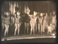
Children's theatrical performance at the Oak Theatre
https://search.heritageburnaby.ca/link/archivedescription85469
- Repository
- City of Burnaby Archives
- Date
- 1939
- Collection/Fonds
- Digney Family fonds
- Description Level
- Item
- Physical Description
- 1 film clip (1 min., 36 sec.) : digital, b&w ; si.
- Scope and Content
- Item is a digitized copy of a black and white film segment of an unidentified theatrical production at the Oak Theatre with children as the performers. Children appear in costume with some dressed as mice or rats and cats dancing and performing on the stage while others are dressed as townsfolk. Th…
- Repository
- City of Burnaby Archives
- Date
- 1939
- Collection/Fonds
- Digney Family fonds
- Physical Description
- 1 film clip (1 min., 36 sec.) : digital, b&w ; si.
- Description Level
- Item
- Record No.
- 562-002-5
- Access Restriction
- No restrictions
- Reproduction Restriction
- May be restricted by third party rights
- Accession Number
- 2012-15
- Scope and Content
- Item is a digitized copy of a black and white film segment of an unidentified theatrical production at the Oak Theatre with children as the performers. Children appear in costume with some dressed as mice or rats and cats dancing and performing on the stage while others are dressed as townsfolk. The play closely resembles the folk tale 'The Pied Piper of Hamelin' (also known as The Pan Piper, the Rat Catcher of Hamelin).
- Names
- Oak Theatre
- Media Type
- Moving Images
- Photographer
- Digney, Andy
- Creator
- Digney, Andy
- Notes
- Title based on contents of film
- Film clip originates from digitized version of original 16 mm film footage (item 562-002). This segment was part of digitized portion titled 'Royal Visit'
- Storage location refers to location of DVD containing this clip. See 562-002 notes for more information. Additional copies of video file stored in Permanent drive accession folder.
- Geographic Access
- Kingsway
- Central Park
- Historic Neighbourhood
- Central Park (Historic Neighbourhood)
- Planning Study Area
- Sussex-Nelson Area
Images
Video
Children's theatrical performance at the Oak Theatre, 1939
Children's theatrical performance at the Oak Theatre, 1939
https://search.heritageburnaby.ca/media/hpo/_Data/_Archives_Moving_Images/_Unrestricted/562-002-5.m4v![Oak Theatre, [between 1937 and 1936] thumbnail](/media/Hpo/_Data/_Archives_Moving_Images/_Unrestricted/562-002-1.jpg?width=280)
Oak Theatre
https://search.heritageburnaby.ca/link/archivedescription85202
- Repository
- City of Burnaby Archives
- Date
- [between 1937 and 1936]
- Collection/Fonds
- Digney Family fonds
- Description Level
- Item
- Physical Description
- 1 film clip (9 min., 26 sec.) : digital, col., si.
- Scope and Content
- Item is a digitized copy of a silent colour film segment with footage of the construction of the Oak Theatre in 1936, the opening of the theatre held on August 4, 1937, the theatre with snow in the winter and the Digney family home and neighborhood . Andy Digney moved with his family from Manitoba …
- Repository
- City of Burnaby Archives
- Date
- [between 1937 and 1936]
- Collection/Fonds
- Digney Family fonds
- Physical Description
- 1 film clip (9 min., 26 sec.) : digital, col., si.
- Description Level
- Item
- Record No.
- 562-002-1
- Access Restriction
- No restrictions
- Reproduction Restriction
- May be restricted by third party rights
- Accession Number
- 2012-15
- Scope and Content
- Item is a digitized copy of a silent colour film segment with footage of the construction of the Oak Theatre in 1936, the opening of the theatre held on August 4, 1937, the theatre with snow in the winter and the Digney family home and neighborhood . Andy Digney moved with his family from Manitoba to Burnaby in 1936 and purchased 2 acres of land where he settled with his family and built the Oak Theatre which was located at 5000 Kingsway (Marlborough & Kingsway). The theatre was located on a 2 acre parcel of land and had a 350 seat capacity and offered valet parking. Construction crews with men and horses can be seen laying the foundation and erecting the walls of the theatre and crowds of people and cars are seen arriving outside the theatre on opening day.
- Subjects
- Events - Openings
- Buildings - Commercial - Theatres
- Recreational Activities - Theatre
- Animals - Horses
- Names
- Oak Theatre
- Digney, Andy
- Media Type
- Moving Images
- Photographer
- Digney, Andy
- Creator
- Digney, Andy
- Notes
- Title based on contents of film
- Film clip originates from digitized version of original 16 mm film footage (item 562-002). This segment was part of digitized portion titled 'Oak Theatre'
- Historic Neighbourhood
- Central Park (Historic Neighbourhood)
- Planning Study Area
- Sussex-Nelson Area
Images
![Oak Theatre, [between 1937 and 1936] thumbnail](/media/Hpo/_Data/_Archives_Moving_Images/_Unrestricted/562-002-1.jpg)
Video
Oak Theatre, [between 1937 and 1936]
Oak Theatre, [between 1937 and 1936]
https://search.heritageburnaby.ca/media/hpo/_Data/_Archives_Moving_Images/_Unrestricted/562-002-1.m4v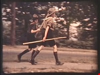
Royal Visit
https://search.heritageburnaby.ca/link/archivedescription85203
- Repository
- City of Burnaby Archives
- Date
- 1939
- Collection/Fonds
- Digney Family fonds
- Description Level
- Item
- Physical Description
- 1 film clip (1 min., 52 sec.) : digital, col., si.
- Scope and Content
- Item is a digitized copy of a silent colour film segment with footage of the Royal Visit from King George VI and Queen consort, Elizabeth. Boy Scouts and members of the community can be seen preparing for a roadside view of the motorcade and Mr. Digney can be seen pacing in his gardens at the Oak T…
- Repository
- City of Burnaby Archives
- Date
- 1939
- Collection/Fonds
- Digney Family fonds
- Physical Description
- 1 film clip (1 min., 52 sec.) : digital, col., si.
- Description Level
- Item
- Record No.
- 562-002-2
- Access Restriction
- No restrictions
- Reproduction Restriction
- No known restrictions
- Accession Number
- 2012-15
- Scope and Content
- Item is a digitized copy of a silent colour film segment with footage of the Royal Visit from King George VI and Queen consort, Elizabeth. Boy Scouts and members of the community can be seen preparing for a roadside view of the motorcade and Mr. Digney can be seen pacing in his gardens at the Oak Theatre. As the royal couple (King George VI and Queen Elizabeth) drive by the crowd on Kingsway, they can be seen in a automobile identified as a McLaughlin model 45 Extra Special series, with Queen Elizabeth holding a white umbrella. RCMP officers are seen on a motorcycle with a side car, while dignitaries and officials in automobiles accompany the royal couple as the crowd waves red flags and looks on as the cars drive off.
- Subjects
- Events - May Day
- Events - Royal Visits
- Buildings - Commercial - Theatres
- Recreational Activities - Theatre
- Names
- Oak Theatre
- Digney, Andy
- Elizabeth, Queen, consort of George VI, King of Great Britain, 1900-2002
- George VI, King of Great Britain, 1895-1952
- Media Type
- Moving Images
- Photographer
- Digney, Andy
- Creator
- Digney, Andy
- Notes
- Title based on contents of film
- Film clip originates from digitized version of original 16 mm film footage (item 562-002). This segment was part of digitized portion titled 'Royal Visit'
- Geographic Access
- Kingsway
- Central Park
- Historic Neighbourhood
- Central Park (Historic Neighbourhood)
- Planning Study Area
- Sussex-Nelson Area
Images

Video
Royal Visit, 1939
![All Saints Church, [ca.1910] thumbnail](/media/hpo/_Data/_BVM_Cartographic_Material/2003/2003_0083_0046_001.jpg?width=280)
All Saints Church
https://search.heritageburnaby.ca/link/museumdescription11924
- Repository
- Burnaby Village Museum
- Date
- [ca.1910]
- Collection/Fonds
- Ronald G. Scobbie collection
- Description Level
- Item
- Physical Description
- 1 plan : black ink and watercol. on paper ; 30.45 x 30.5 cm
- Scope and Content
- Item consists of building insurance plan of "All Saints Church / Lot "A" BK 29 DL 98 GP1 N.W.D.". Watling Street is idenfied to the north of the church building and Royal Oak Avenue to the west.
- Repository
- Burnaby Village Museum
- Collection/Fonds
- Ronald G. Scobbie collection
- Description Level
- Item
- Physical Description
- 1 plan : black ink and watercol. on paper ; 30.45 x 30.5 cm
- Material Details
- Scale 1 inch = 20 feet
- Scope and Content
- Item consists of building insurance plan of "All Saints Church / Lot "A" BK 29 DL 98 GP1 N.W.D.". Watling Street is idenfied to the north of the church building and Royal Oak Avenue to the west.
- Subjects
- Buildings - Religious - Churches
- Accession Code
- BV003.83.46
- Access Restriction
- No restrictions
- Reproduction Restriction
- No known restrictions
- Date
- [ca.1910]
- Media Type
- Cartographic Material
- Scan Resolution
- 600
- Scan Date
- 15-Jan-2021
- Scale
- 100
- Notes
- Transcribed title
- Note in pencil on verso reads: ""All Saints Church / Lot "A" BK 29 DL 98 / Scale 1 inch = 20 feet"
- Note in balck in on verso reads: "3704"
Images
![All Saints Church, [ca.1910] thumbnail](/media/hpo/_Data/_BVM_Cartographic_Material/2003/2003_0083_0046_001.jpg)
![Anglican Church, [ca.1910] thumbnail](/media/hpo/_Data/_BVM_Cartographic_Material/2003/2003_0083_0043_001.jpg?width=280)
Anglican Church
https://search.heritageburnaby.ca/link/museumdescription11921
- Repository
- Burnaby Village Museum
- Date
- [ca.1910]
- Collection/Fonds
- Ronald G. Scobbie collection
- Description Level
- Item
- Physical Description
- 1 plan : black ink and watercol. on paper ; 30.45 x 30.5 cm
- Scope and Content
- Item consists of building insurance plan of "Anglican Church / Lot 2 BK 37 DL69, GP.1, N.W.D. (15th Ave. (Dominion) is identified to the north of Lots 1, 2 and 3).
- Repository
- Burnaby Village Museum
- Collection/Fonds
- Ronald G. Scobbie collection
- Description Level
- Item
- Physical Description
- 1 plan : black ink and watercol. on paper ; 30.45 x 30.5 cm
- Material Details
- Scale 1 inch = 20 feet
- Scope and Content
- Item consists of building insurance plan of "Anglican Church / Lot 2 BK 37 DL69, GP.1, N.W.D. (15th Ave. (Dominion) is identified to the north of Lots 1, 2 and 3).
- Subjects
- Buildings - Religious - Churches
- Accession Code
- BV003.83.43
- Access Restriction
- No restrictions
- Reproduction Restriction
- No known restrictions
- Date
- [ca.1910]
- Media Type
- Cartographic Material
- Scan Resolution
- 600
- Scan Date
- 15-Jan-2021
- Scale
- 100
- Notes
- Transcribed title
- Note in pencil on verso reads: "Anglican Church / Lot 2 Bk 37 DL69 / 1"=20' "
- Note in balck in on verso reads: "3704"
Images
![Anglican Church, [ca.1910] thumbnail](/media/hpo/_Data/_BVM_Cartographic_Material/2003/2003_0083_0043_001.jpg)

Armstrong Street School site
https://search.heritageburnaby.ca/link/museumdescription11133
- Repository
- Burnaby Village Museum
- Date
- 1915
- Collection/Fonds
- Ronald G. Scobbie collection
- Description Level
- Item
- Physical Description
- 1 survey plan : blueprint on paper ; 56 x 54 cm
- Scope and Content
- Survey plan of "Armstrong Street School Site / Burnaby Municipality" "Being a 2 acre portion of Lot 13 Group 1, & according to map 1722 which shows this as Lot E. Block 2 of subdivision of a portion, of Lot 13, Group 1, New Westminster District".
- Repository
- Burnaby Village Museum
- Collection/Fonds
- Ronald G. Scobbie collection
- Description Level
- Item
- Physical Description
- 1 survey plan : blueprint on paper ; 56 x 54 cm
- Material Details
- Scale 40 feet = 1 inch
- Scope and Content
- Survey plan of "Armstrong Street School Site / Burnaby Municipality" "Being a 2 acre portion of Lot 13 Group 1, & according to map 1722 which shows this as Lot E. Block 2 of subdivision of a portion, of Lot 13, Group 1, New Westminster District".
- Creator
- Burnett, Geoffrey K.
- Subjects
- Buildings - Schools
- Names
- Armstrong Avenue School
- Responsibility
- Burnett & McGugan, Engineers and Surveyors
- Geographic Access
- Armstrong Avenue
- Street Address
- 8757 Armstrong Avenue
- Accession Code
- BV003.83.12
- Access Restriction
- No restrictions
- Reproduction Restriction
- No known restrictions
- Date
- 1915
- Media Type
- Cartographic Material
- Historic Neighbourhood
- East Burnaby (Historic Neighbourhood)
- Planning Study Area
- Cariboo-Armstrong Area
- Scan Resolution
- 440
- Scan Date
- 22-Dec-2020
- Scale
- 100
- Notes
- Title based on contents of plan
- Note in black ink on verso of plan reads: "1746"
- Oath on plan reads: "I, Geoffrey K. Burnett...and did personally superintend the survey represented..." "Completed on the 18th day of March 1915"; signed by Geoffrey K. Burnett and notarized by "K.A. Eastman", sworn "...19th day of April 1915"; "Burnett and McGugan., B.C. Land Surveyors. Etc.. New Westminster, B.C.."
Zoomable Images


Barnet School site
https://search.heritageburnaby.ca/link/museumdescription11140
- Repository
- Burnaby Village Museum
- Date
- May 27, 1915
- Collection/Fonds
- Ronald G. Scobbie collection
- Description Level
- Item
- Physical Description
- 1 survey plan : blueprint on paper ; 56 x 54 cm
- Scope and Content
- Survey plan of "Barnet School Site / Burnaby Municipality" "Being a portion of the west half of lot / 214, Group 1 / New Westminster District”.
- Repository
- Burnaby Village Museum
- Collection/Fonds
- Ronald G. Scobbie collection
- Description Level
- Item
- Physical Description
- 1 survey plan : blueprint on paper ; 56 x 54 cm
- Material Details
- Scale 40 feet = 1 inch
- Scope and Content
- Survey plan of "Barnet School Site / Burnaby Municipality" "Being a portion of the west half of lot / 214, Group 1 / New Westminster District”.
- Creator
- McGugan, Donald Johnston
- Subjects
- Buildings - Schools
- Names
- Barnet School
- Responsibility
- Burnett & McGugan, Engineers and Surveyors
- Geographic Access
- Barnet Road
- Street Address
- 7820 Barnet Road
- Accession Code
- BV003.83.19
- Access Restriction
- No restrictions
- Reproduction Restriction
- No known restrictions
- Date
- May 27, 1915
- Media Type
- Cartographic Material
- Historic Neighbourhood
- Barnet (Historic Neighbourhood)
- Planning Study Area
- Burnaby Mountain Area
- Scan Resolution
- 440
- Scan Date
- 22-Dec-2020
- Scale
- 100
- Notes
- Title based on contents of plan
- handwritten on back "Burnaby Schools" "23R" twice, "1783"
- Oath on plan reads: "I, D.J. McGugan...and did personally superintend the survey..." "completed on the 27th day of May 1915"; signed by D.J. McGugan, notarized by "Walter Edmonds" "sworn "...29th day of May 1915" "Burnett and McGugan" "B.C. Land Surveyors Etc. New Westminster, B.C.";
Zoomable Images

![Broadview Presbyterian Church, [ca.1910] thumbnail](/media/hpo/_Data/_BVM_Cartographic_Material/2003/2003_0083_0049_001.jpg?width=280)
Broadview Presbyterian Church
https://search.heritageburnaby.ca/link/museumdescription11927
- Repository
- Burnaby Village Museum
- Date
- [ca.1910]
- Collection/Fonds
- Ronald G. Scobbie collection
- Description Level
- Item
- Physical Description
- 1 plan : black ink and watercol. on paper ; 30.45 x 30.5 cm
- Scope and Content
- Item consists of building insurance plan of "Broadview Presbyterian Church / Lot 6, BK 31, DL 69 / GP1 N.W.D." . Fourteenth Avenue (Manor) is identified to the north and Douglas Ave. to the east.
- Repository
- Burnaby Village Museum
- Collection/Fonds
- Ronald G. Scobbie collection
- Description Level
- Item
- Physical Description
- 1 plan : black ink and watercol. on paper ; 30.45 x 30.5 cm
- Material Details
- Scale 1 inch = 20 feet
- Scope and Content
- Item consists of building insurance plan of "Broadview Presbyterian Church / Lot 6, BK 31, DL 69 / GP1 N.W.D." . Fourteenth Avenue (Manor) is identified to the north and Douglas Ave. to the east.
- Subjects
- Buildings - Religious - Churches
- Accession Code
- BV003.83.49
- Access Restriction
- No restrictions
- Reproduction Restriction
- No known restrictions
- Date
- [ca.1910]
- Media Type
- Cartographic Material
- Scan Resolution
- 600
- Scan Date
- 15-Jan-2021
- Scale
- 100
- Notes
- Transcribed title
- Note in pencil on verso reads: "Broadview Presbyterian Church / Lot 6, BK 31, DL 69 / 1" = 20' "
- Note in balck in on verso reads: "3704"
Images
![Broadview Presbyterian Church, [ca.1910] thumbnail](/media/hpo/_Data/_BVM_Cartographic_Material/2003/2003_0083_0049_001.jpg)

Douglas Road School site
https://search.heritageburnaby.ca/link/museumdescription11136
- Repository
- Burnaby Village Museum
- Date
- April 19, 1915
- Collection/Fonds
- Ronald G. Scobbie collection
- Description Level
- Item
- Physical Description
- 1 survey plan : blueprint on paper ; 56 x 54 cm
- Scope and Content
- Survey plan of "Douglas Road School Site / Burnaby Municipality" "Being Lot 21, of Blocks 1-5 inc. 11 & 12 of the subd. of north half of Lot 80, Group 1, New Westminster District".
- Repository
- Burnaby Village Museum
- Collection/Fonds
- Ronald G. Scobbie collection
- Description Level
- Item
- Physical Description
- 1 survey plan : blueprint on paper ; 56 x 54 cm
- Material Details
- Scale 40 feet = 1 inch
- Scope and Content
- Survey plan of "Douglas Road School Site / Burnaby Municipality" "Being Lot 21, of Blocks 1-5 inc. 11 & 12 of the subd. of north half of Lot 80, Group 1, New Westminster District".
- Creator
- McGugan, Donald Johnston
- Subjects
- Buildings - Schools
- Names
- Douglas Road School
- Responsibility
- Burnett & McGugan, Engineers and Surveyors
- Geographic Access
- Canada Way
- Street Address
- 4861 Canada Way
- Accession Code
- BV003.83.15
- Access Restriction
- No restrictions
- Reproduction Restriction
- No known restrictions
- Date
- April 19, 1915
- Media Type
- Cartographic Material
- Historic Neighbourhood
- Burnaby Lake (Historic Neighbourhood)
- Planning Study Area
- Douglas-Gilpin Area
- Scan Resolution
- 440
- Scan Date
- 22-Dec-2020
- Scale
- 100
- Notes
- Title based on contents of plan
- Note in black ink on verso of plan reads: "1747"
- Oath on plan reads: "I, D.G. McGugan..." "...and did person- ally superintend the survey..." "...completed on the 3rd day of April 1915"; signed by D.J. McGugan, notarized by "H.A. Eastman", sworn "...19th day of April 1915" "Burnett and McGugan" "B.C. Land Surveyors Etc. New Westminster, B.C.."
Images

![Dundonald United Church, [ca.1910] thumbnail](/media/hpo/_Data/_BVM_Cartographic_Material/2003/2003_0083_0052_001.jpg?width=280)
Dundonald United Church
https://search.heritageburnaby.ca/link/museumdescription11930
- Repository
- Burnaby Village Museum
- Date
- [ca.1910]
- Collection/Fonds
- Ronald G. Scobbie collection
- Description Level
- Item
- Physical Description
- 1 plan : black ink and watercol. on paper ; 30.45 x 30.5 cm
- Scope and Content
- Item consists of a building insurance plan of "Dundonald United Church / Lots 9, 10 BK 28 DL 159 GP 1 / N.W.D.". Clinton Street is identified to the north of Lots nine and ten.
- Repository
- Burnaby Village Museum
- Collection/Fonds
- Ronald G. Scobbie collection
- Description Level
- Item
- Physical Description
- 1 plan : black ink and watercol. on paper ; 30.45 x 30.5 cm
- Material Details
- Scale 1 inch = 20 feet
- Scope and Content
- Item consists of a building insurance plan of "Dundonald United Church / Lots 9, 10 BK 28 DL 159 GP 1 / N.W.D.". Clinton Street is identified to the north of Lots nine and ten.
- Subjects
- Buildings - Religious - Churches
- Names
- Dundonald United Church
- Accession Code
- BV003.83.52
- Access Restriction
- No restrictions
- Reproduction Restriction
- No known restrictions
- Date
- [ca.1910]
- Media Type
- Cartographic Material
- Scan Resolution
- 600
- Scan Date
- 15-Jan-2021
- Scale
- 100
- Notes
- Transcribed title
- Note in pencil on verso reads: "_ _Church / Lots 9 & 10 BK 28 DL 159 / 1" = 20' "
- Note in black ink on verso reads: "3704"
Images
![Dundonald United Church, [ca.1910] thumbnail](/media/hpo/_Data/_BVM_Cartographic_Material/2003/2003_0083_0052_001.jpg)

Edmonds Street School site
https://search.heritageburnaby.ca/link/museumdescription11125
- Repository
- Burnaby Village Museum
- Date
- March 8, 1915
- Collection/Fonds
- Ronald G. Scobbie collection
- Description Level
- Item
- Physical Description
- 1 survey plan : blueprint on paper ; 56 x 54 cm
- Scope and Content
- Survey plan of "Edmonds Street School Site" "Burnaby Municipality" "Being Lots 28 and 29 of the Subdivision of Lot 30, Group 1, New Westminster District";
- Repository
- Burnaby Village Museum
- Collection/Fonds
- Ronald G. Scobbie collection
- Description Level
- Item
- Physical Description
- 1 survey plan : blueprint on paper ; 56 x 54 cm
- Material Details
- Scale: 4 feet = 1 inch
- Scope and Content
- Survey plan of "Edmonds Street School Site" "Burnaby Municipality" "Being Lots 28 and 29 of the Subdivision of Lot 30, Group 1, New Westminster District";
- Subjects
- Buildings - Schools
- Names
- Edmonds Community School
- Responsibility
- Burnett and McGugan B.C. Land Surveyors, New Westminster
- Geographic Access
- Edmonds Street
- Street Address
- 7641 Edmonds Street
- Accession Code
- BV003.83.5
- Access Restriction
- No restrictions
- Reproduction Restriction
- No known restrictions
- Date
- March 8, 1915
- Media Type
- Cartographic Material
- Historic Neighbourhood
- Edmonds (Historic Neighbourhood)
- Planning Study Area
- Edmonds Area
- Scan Resolution
- 440
- Scan Date
- 22-Dec-2020
- Scale
- 100
- Notes
- Title based on contents of plan
- Oath in bottom left corner reads: "I, D.J. McGugan...and did personally superintend the survey..." "...completed on the 8th day of March 1915"; signed "D.J. McGugan", notarized by "S.F. Mark" "sworn...12th Day of April 1915"
- handwritten on back, "1756"
Zoomable Images


Gilmour Avenue School site
https://search.heritageburnaby.ca/link/museumdescription11129
- Repository
- Burnaby Village Museum
- Date
- May 27, 1915
- Collection/Fonds
- Ronald G. Scobbie collection
- Description Level
- Item
- Physical Description
- 1 survey plan : blueprint on paper ; 56 x 54 cm
- Scope and Content
- Survey plan of Gilmore Avenue School site. Title on plan reads: "Gilmour Avenue School Site / Burnaby Municipality / Being Lots 1-10 inc. & Lots 27-36 inc. of Block 9 / of Subdivision of a Portion of Lot 187, GP.1 / New Westminster District". "Note. School site is as shown below, the original...am…
- Repository
- Burnaby Village Museum
- Collection/Fonds
- Ronald G. Scobbie collection
- Description Level
- Item
- Physical Description
- 1 survey plan : blueprint on paper ; 56 x 54 cm
- Material Details
- Scale: 40 feet = 1 inch
- Scope and Content
- Survey plan of Gilmore Avenue School site. Title on plan reads: "Gilmour Avenue School Site / Burnaby Municipality / Being Lots 1-10 inc. & Lots 27-36 inc. of Block 9 / of Subdivision of a Portion of Lot 187, GP.1 / New Westminster District". "Note. School site is as shown below, the original...amended" "by cancelling Lots 1-10 & 27-30 inc....order of court filed No.4938".
- History
- The school was named after Hugh B. Gilmour, but an error by a municipal clerk in the Street Naming Bylaw in 1912 (Bylaw Number 135) changed the spelling to "Gilmore" Avenue and the school name was spelled "Gilmore" Avenue School hereafter.
- Creator
- McGugan, Donald Johnston
- Subjects
- Buildings - Schools
- Names
- Gilmore Avenue School
- Responsibility
- Burnett & McGugan, Engineers and Surveyors
- Geographic Access
- Gilmore Avenue
- Accession Code
- BV003.83.8
- Access Restriction
- No restrictions
- Reproduction Restriction
- No known restrictions
- Date
- May 27, 1915
- Media Type
- Cartographic Material
- Historic Neighbourhood
- Vancouver Heights (Historic Neighbourhood)
- Planning Study Area
- Willingdon Heights Area
- Scan Resolution
- 440
- Scan Date
- 22-Dec-2020
- Scale
- 100
- Notes
- Transcribed title taken from plan
- Oath in bottom left corner reads: "I, D.J. McGugan...did superintend the survey", "...completed on the 27th day of May 1915" and noterized by Walter Edmonds" "sworn...29th Day of May 1915"; "Burnett and McGugan. B.C. Land Surveyors Etc. New Westminster. B.C."
- Note in black ink on verso of plan reads: "1782"
Zoomable Images

![Gordon Presbyterian Church, [ca.1912] thumbnail](/media/hpo/_Data/_BVM_Cartographic_Material/2003/2003_0083_0045_001.jpg?width=280)
Gordon Presbyterian Church
https://search.heritageburnaby.ca/link/museumdescription11923
- Repository
- Burnaby Village Museum
- Date
- [ca.1912]
- Collection/Fonds
- Ronald G. Scobbie collection
- Description Level
- Item
- Physical Description
- 1 plan : black ink and watercol. on paper ; 30.45 x 30.5 cm
- Scope and Content
- Item consists of building insurance plan of "Gordon Presbyterian Church / Blocks 1-2 BK 7 DL 30 GP1 N.W.D.". Arbutus Street is identified to the north of Lots 1, 2, & 3 and Humphries Avenue to the east.
- Repository
- Burnaby Village Museum
- Collection/Fonds
- Ronald G. Scobbie collection
- Description Level
- Item
- Physical Description
- 1 plan : black ink and watercol. on paper ; 30.45 x 30.5 cm
- Material Details
- Scale 1 inch = 20 feet
- Scope and Content
- Item consists of building insurance plan of "Gordon Presbyterian Church / Blocks 1-2 BK 7 DL 30 GP1 N.W.D.". Arbutus Street is identified to the north of Lots 1, 2, & 3 and Humphries Avenue to the east.
- Subjects
- Buildings - Religious - Churches
- Accession Code
- BV003.83.45
- Access Restriction
- No restrictions
- Reproduction Restriction
- No known restrictions
- Date
- [ca.1912]
- Media Type
- Cartographic Material
- Scan Resolution
- 600
- Scan Date
- 15-Jan-2021
- Scale
- 100
- Notes
- Transcribed title
- Note in pencil on verso reads: "Gordon Presbyterian Church / Blocks 1-2 BK 7 DL 30 / Scale 1 inch = 20 feet" "Total area Lot 1 / Portion exempted / Total area Lot 2 / Portion exempted"
- Note in balck in on verso reads: "3704"
Images
![Gordon Presbyterian Church, [ca.1912] thumbnail](/media/hpo/_Data/_BVM_Cartographic_Material/2003/2003_0083_0045_001.jpg)

Hamilton Road School site
https://search.heritageburnaby.ca/link/museumdescription11139
- Repository
- Burnaby Village Museum
- Date
- April 27, 1915
- Collection/Fonds
- Ronald G. Scobbie collection
- Description Level
- Item
- Physical Description
- 1 survey plan : blueprint on paper ; 56 x 54 cm
- Scope and Content
- Survey plan of "Hamilton Road School Site / Burnaby Municipality" "Being the westerly 2 acres of Block 2 of the subd. of a portion of Lot 8, Group 1"; "New Westminster District”.
- Repository
- Burnaby Village Museum
- Collection/Fonds
- Ronald G. Scobbie collection
- Description Level
- Item
- Physical Description
- 1 survey plan : blueprint on paper ; 56 x 54 cm
- Material Details
- Scale 40 feet = 1 inch
- Scope and Content
- Survey plan of "Hamilton Road School Site / Burnaby Municipality" "Being the westerly 2 acres of Block 2 of the subd. of a portion of Lot 8, Group 1"; "New Westminster District”.
- Creator
- Burnett, Geoffrey K.
- Subjects
- Buildings - Schools
- Names
- Hamilton Road School
- Responsibility
- Burnett & McGugan, Engineers and Surveyors
- Geographic Access
- Lyndhurst Street
- Accession Code
- BV003.83.18
- Access Restriction
- No restrictions
- Reproduction Restriction
- No known restrictions
- Date
- April 27, 1915
- Media Type
- Cartographic Material
- Historic Neighbourhood
- Burquitlam (Historic Neighbourhood)
- Planning Study Area
- Sperling-Broadway Area
- Scan Resolution
- 440
- Scan Date
- 22-Dec-2020
- Scale
- 100
- Notes
- Title based on contents of plan
- handwritten on back, "1752" and mathematical calculations
- Oath on plan reads: "I, Geoffrey K. Burnett...and did person- ally superintend the survey..." "...completed on the 27th day of April 1915"; signed by Geoffrey K. Burnett, notary illegible, sworn "...27th day of April 1915" "Burnett and McGugan" "B.C. Land Surveyors Etc. New Westminster, B.C."
Images


Howard Avenue School site
https://search.heritageburnaby.ca/link/museumdescription11124
- Repository
- Burnaby Village Museum
- Date
- March 24, 1915
- Collection/Fonds
- Ronald G. Scobbie collection
- Description Level
- Item
- Physical Description
- 1 survey plan : blueprint on paper ; 56 x 54 cm
- Scope and Content
- Survey plan of "Howard Avenue School Site" "Burnaby Municipality", "Being Lots 1-5 and 14-18 Inc. Block 5 of the Subd. of Easterly 3/4 of Lot 127. Group 1, New Westminster District";
- Repository
- Burnaby Village Museum
- Collection/Fonds
- Ronald G. Scobbie collection
- Description Level
- Item
- Physical Description
- 1 survey plan : blueprint on paper ; 56 x 54 cm
- Material Details
- Scale: 40 feet = 1 inch
- Scope and Content
- Survey plan of "Howard Avenue School Site" "Burnaby Municipality", "Being Lots 1-5 and 14-18 Inc. Block 5 of the Subd. of Easterly 3/4 of Lot 127. Group 1, New Westminster District";
- Creator
- McGugan, Donald Johnston
- Subjects
- Buildings - Schools
- Names
- Howard Avenue School
- Responsibility
- Burnett and McGugan B.C. Land Surveyors, New Westminster
- Geographic Access
- Howard Avenue
- Georgia Street
- Accession Code
- BV003.83.4
- Access Restriction
- No restrictions
- Reproduction Restriction
- No known restrictions
- Date
- March 24, 1915
- Media Type
- Cartographic Material
- Historic Neighbourhood
- Capitol Hill (Historic Neighbourhood)
- Planning Study Area
- Capitol Hill Area
- Scan Resolution
- 440
- Scan Date
- 22-Dec-2020
- Scale
- 100
- Notes
- Title based on contents of plan
- Oath in bottom left corner reads: "I, D.J. McGugan...and did personally superintend the survey..." "...completed on the 24th day of March 1915"; signed "D.J. McGugan", notarized on April 12th, 1915 by "R. Chapman"
- handwritten on back, "1754"
Zoomable Images


Inman Avenue School site
https://search.heritageburnaby.ca/link/museumdescription11128
- Repository
- Burnaby Village Museum
- Date
- May 3, 1915
- Collection/Fonds
- Ronald G. Scobbie collection
- Description Level
- Item
- Physical Description
- 1 survey plan : blueprint on paper ; 56 x 54 cm
- Scope and Content
- Survey plan of "Inman Avenue School Site" "Burnaby Municipality" "Being Lots 3 -12 inc. Blk. C. of Subd. of Blks.5" "13-19 inc. & 21-28 inc. of Subd. of Westerly 80 Acres of, and portion of D.L. 34, Group One. New Westminster District".
- Repository
- Burnaby Village Museum
- Collection/Fonds
- Ronald G. Scobbie collection
- Description Level
- Item
- Physical Description
- 1 survey plan : blueprint on paper ; 56 x 54 cm
- Material Details
- Scale: 40 feet = 1 inch
- Scope and Content
- Survey plan of "Inman Avenue School Site" "Burnaby Municipality" "Being Lots 3 -12 inc. Blk. C. of Subd. of Blks.5" "13-19 inc. & 21-28 inc. of Subd. of Westerly 80 Acres of, and portion of D.L. 34, Group One. New Westminster District".
- Creator
- McGugan, Donald Johnston
- Subjects
- Buildings - Schools
- Names
- Inman Avenue School
- Responsibility
- Burnett & McGugan, Engineers and Surveyors
- Geographic Access
- Brandon Street
- Street Address
- 3963 Brandon Street
- Accession Code
- BV003.83.7
- Access Restriction
- No restrictions
- Reproduction Restriction
- No known restrictions
- Date
- May 3, 1915
- Media Type
- Cartographic Material
- Historic Neighbourhood
- Central Park (Historic Neighbourhood)
- Planning Study Area
- Garden Village Area
- Scan Resolution
- 440
- Scan Date
- 22-Dec-2020
- Scale
- 100
- Notes
- Title based on contents of plan
- Oath in bottom left corner reads: "I, D.J. McGugan...did...superintend the survey...", "...completed on the 3rd day of May 1915"; signed "D.J. McGugan", notariz- ed by "Walter Edmonds" "sworn...22nd Day of May 1915"; "Burnett and McGugan. B.C. Land Surveyors. Etc. New Westminster. B.C.";
- handwritten note reads: "Note: Before using this Mon. see plan / of resubdivision of Lots 5 & 6 / of Block 'B' D.L. 34 / June 1945"
- handwritten twice on back, "1776"
Zoomable Images


Interviews with Bill and Albert Parker by Colin Stevens January 17, 1992
https://search.heritageburnaby.ca/link/museumdescription9840
- Repository
- Burnaby Village Museum
- Date
- 1920-1930 (interview content), interviewed January 17, 1992 (date of original), digitized 2020
- Collection/Fonds
- Burnaby Village Museum fonds
- Description Level
- Item
- Physical Description
- 1 videocassette (53 min., 14 sec.) : col. , sd.
- Scope and Content
- Film footage documenting informal interviews with brothers William “Bill” and Albert Parker conducted by Burnaby Village Museum curator, Colin Stevens. The footage opens in the administration building of the Burnaby Village Museum where Bill Parker describes a pair of cross country skis that he is …
- Repository
- Burnaby Village Museum
- Collection/Fonds
- Burnaby Village Museum fonds
- Series
- Jesse Love farmhouse series
- Description Level
- Item
- Physical Description
- 1 videocassette (53 min., 14 sec.) : col. , sd.
- Material Details
- Interviewer: Colin Stevens
- Interviewee:William (Bill) Parker; Albert Parker; Mrs. William Parker
- Location of Interview: Jesse Love farmhouse at the Burnaby Village Museum
- Camera: Susan Green and Colin Stevens
- Scope and Content
- Film footage documenting informal interviews with brothers William “Bill” and Albert Parker conducted by Burnaby Village Museum curator, Colin Stevens. The footage opens in the administration building of the Burnaby Village Museum where Bill Parker describes a pair of cross country skis that he is donating to the museum. Bill recollects how he constructed the skis out of cedar in the late 1920s when he was about 9 or 10 years old. Bill tells of how he skied in the neighbourhood of the Jesse Love farmhouse on Cumberland Road, using the skis until the mid to late 1930s. The film continues with a tour of the Jesse Love farmhouse which is under restoration on site of the Burnaby Village Museum. Curator Colin Stevens takes Albert and Bill Parker through various rooms inside of the house sharing details of what staff have discovered during the restoration process and gathers informative details by interviewing them. During the interviews, the brothers recollect what it was like living in the house in the 1920s. They provide details on the house’s construction, fixtures, heating and water systems along with particulars regarding furnishings and décor. Information that was gathered through interviews such as this, supported the restoration to be completed as accurately as possible.
- History
- Albert and William Charles “Bill” Parker are the sons of Sarah Parker (nee Love) and William Parker. Sarah Parker was the daughter of Jesse and Martha Love and grew up in the Love farmhouse located at 1390 Cumberland Road in Burnaby. Sarah and William Parker and their three children (Albert, Bill and Elsie) moved into the Love farmhouse in about 1925, eventually buying it in 1928 following the death of Sarah’s father Jesse Love. Sarah continued to live in the house until after her husband William died and eventually sold the house to her daughter Elsie Hughes and her husband John Hughes in 1966.
- Creator
- Burnaby Village Museum
- Subjects
- Sports - Skiing
- Buildings - Heritage
- Accession Code
- BV018.41.50
- Access Restriction
- Restricted access
- Reproduction Restriction
- May be restricted by third party rights
- Date
- 1920-1930 (interview content), interviewed January 17, 1992 (date of original), digitized 2020
- Media Type
- Moving Images
- Photographer
- Green, Susan
- Stevens, Colin
- Notes
- Title based on contents of video
- Video was digitized to mp4 in March 2020 from original VHS tape
Images

Video
Interviews with Bill and Albert Parker by Colin Stevens January 17, 1992, 1920-1930 (interview content), interviewed January 17, 1992 (date of original), digitized 2020
Interviews with Bill and Albert Parker by Colin Stevens January 17, 1992, 1920-1930 (interview content), interviewed January 17, 1992 (date of original), digitized 2020
https://search.heritageburnaby.ca/media/hpo/_Data/_BVM_Moving_Images/2018_0041_0050_001.mp4
Kingsway East School
https://search.heritageburnaby.ca/link/museumdescription11121
- Repository
- Burnaby Village Museum
- Date
- April 27, 1915
- Collection/Fonds
- Ronald G. Scobbie collection
- Description Level
- Item
- Physical Description
- 1 survey plan : blueprint on paper ; 56 x 54 cm
- Scope and Content
- Survey plan of "Kingsway East School Site" "Burnaby Municipality" / "Lot 10, of the Subdivision of Lot "D" of... Lot 96, Group 1, New Westminster District"
- Repository
- Burnaby Village Museum
- Collection/Fonds
- Ronald G. Scobbie collection
- Description Level
- Item
- Physical Description
- 1 survey plan : blueprint on paper ; 56 x 54 cm
- Material Details
- Scale: 40 feet = 1 inch
- Scope and Content
- Survey plan of "Kingsway East School Site" "Burnaby Municipality" / "Lot 10, of the Subdivision of Lot "D" of... Lot 96, Group 1, New Westminster District"
- Subjects
- Buildings - Schools
- Names
- Kingsway East School
- Geographic Access
- Kingsway
- Mission Avenue
- Street Address
- 6650 Southoaks Crescent
- Accession Code
- BV003.83.1
- Access Restriction
- No restrictions
- Reproduction Restriction
- No known restrictions
- Date
- April 27, 1915
- Media Type
- Cartographic Material
- Historic Neighbourhood
- Edmonds (Historic Neighbourhood)
- Planning Study Area
- Kingsway-Beresford Area
- Scan Resolution
- 440
- Scan Date
- 22-Dec-2020
- Scale
- 100
- Notes
- Title based on contents of plan
- handwritten on back, "1753"
- signed "Geoffrey Burnett"; notarized, signature illegible
- "Oath of I, Geoffrey K. Burnett...did personally superintend the survey..." "Survey was completed on the 27th day of April 1915.
Zoomable Images


Kingsway West School site
https://search.heritageburnaby.ca/link/museumdescription11122
- Repository
- Burnaby Village Museum
- Date
- March 16, 1915
- Collection/Fonds
- Ronald G. Scobbie collection
- Description Level
- Item
- Physical Description
- 1 survey plan : blueprint on paper with pencil notations ; 56 x 54 cm
- Scope and Content
- Survey plan of "Kingsway West School Site" "Burnaby Municipality" "being Lot 1, D.L.32, Lot 1 of Lot 21, Portion of Lot 21 and Portion of Lot 20, of subdivision of D.L.152, 153 & Portion of Lot 151, Group 1, New Westminster District". Notations in pencil extend along the south boundary line of Dist…
- Repository
- Burnaby Village Museum
- Collection/Fonds
- Ronald G. Scobbie collection
- Description Level
- Item
- Physical Description
- 1 survey plan : blueprint on paper with pencil notations ; 56 x 54 cm
- Material Details
- Scale: 40 feet = 1 inch
- Scope and Content
- Survey plan of "Kingsway West School Site" "Burnaby Municipality" "being Lot 1, D.L.32, Lot 1 of Lot 21, Portion of Lot 21 and Portion of Lot 20, of subdivision of D.L.152, 153 & Portion of Lot 151, Group 1, New Westminster District". Notations in pencil extend along the south boundary line of District Lot 32.
- Creator
- McGugan, Donald Johnston
- Subjects
- Buildings - Schools
- Names
- Kingsway West School
- Responsibility
- Burnett and McGugan B.C. Land Surveyors, New Westminster
- Geographic Access
- Kingsway
- Sussex Avenue
- Accession Code
- BV003.83.2
- Access Restriction
- No restrictions
- Reproduction Restriction
- No known restrictions
- Date
- March 16, 1915
- Media Type
- Cartographic Material
- Historic Neighbourhood
- Central Park (Historic Neighbourhood)
- Planning Study Area
- Maywood Area
- Scan Resolution
- 440
- Scan Date
- 22-Dec-2020
- Scale
- 100
- Notes
- Transcribed title
- Oath in bottom left corner reads: "I, D.J. McGugan...did personally superintend the survey ..." "...completed on the 16th day of March 1915", signed "D.J. McGugan" and is notarized on March 19th, 1915 by "S.F. Frank" with a seal
- handwritten on back, "1753";
- See also BV003.83.9 - duplicate blueprint plan without annotations
- See also BV003.83.3 for original plan on waxed linen
Zoomable Images

Kingsway West School site
https://search.heritageburnaby.ca/link/museumdescription11123
- Repository
- Burnaby Village Museum
- Date
- March 16, 1915
- Collection/Fonds
- Ronald G. Scobbie collection
- Description Level
- Item
- Physical Description
- 1 survey plan : blackline print on waxed linen ; 59 x 59 cm
- Scope and Content
- Survey plan titled “Kingsway West School Site" "Burnaby Municipality" / being Lot 1, D.L.32, Lot 1 of Lot 21, Portion of / Lot 21 and Portion of Lot 20, of subdivision / of D.L.152, 153 & Portion of Lot 151, Group 1 / New Westminster District".
- Repository
- Burnaby Village Museum
- Collection/Fonds
- Ronald G. Scobbie collection
- Description Level
- Item
- Physical Description
- 1 survey plan : blackline print on waxed linen ; 59 x 59 cm
- Material Details
- Scale [1:480]
- Scope and Content
- Survey plan titled “Kingsway West School Site" "Burnaby Municipality" / being Lot 1, D.L.32, Lot 1 of Lot 21, Portion of / Lot 21 and Portion of Lot 20, of subdivision / of D.L.152, 153 & Portion of Lot 151, Group 1 / New Westminster District".
- Subjects
- Buildings - Schools
- Names
- Kingsway West School
- Geographic Access
- Kingsway
- Sussex Avenue
- Accession Code
- BV003.83.3
- Access Restriction
- No restrictions
- Reproduction Restriction
- No known restrictions
- Date
- March 16, 1915
- Media Type
- Cartographic Material
- Historic Neighbourhood
- Central Park (Historic Neighbourhood)
- Planning Study Area
- Maywood Area
- Notes
- Transcribed title
- Scale on plan reads" 40 feet = 1 inch"
- Oath on plan reads: "I, D.J. McGugan...did personally superintend the survey ..." "...completed on the 16th day of March 1915", signed "D.J. McGugan", and notarized by "S.F. Mark
- See also BV0003.83.2 for digitized blueprint