Narrow Results By
Decade
- 2020s 267
- 2010s 391
- 2000s 897
- 1990s 987
- 1980s 962
- 1970s 1704
- 1960s 693
- 1950s 907
- 1940s 787
- 1930s 677
- 1920s
- 1910s 760
- 1900s 271
- 1890s 76
- 1880s 58
- 1870s 9
- 1860s
- 1850s 4
- 1840s 1
- 1830s 1
- 1820s 1
- 1810s 1
- 1800s 1
- 1790s 1
- 1780s 1
- 1770s 1
- 1760s 1
- 1750s 1
- 1740s 1
- 1730s 1
- 1720s 1
- 1710s 1
- 1700s 1
- 1690s 1
- 1680s 1
- 1670s 1
- 1660s 1
- 1650s 1
- 1640s 1
- 1630s 1
- 1620s 1
- 1610s 1
- 1600s 1
- 1520s 1
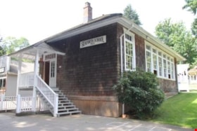
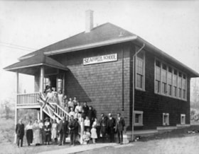
Seaforth Schoolhouse
https://search.heritageburnaby.ca/link/landmark541
- Repository
- Burnaby Heritage Planning
- Description
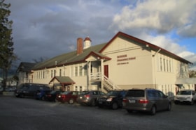
- The Seaforth Schoolhouse is a one-storey wood-frame rectangular plan building with a projecting entry porch, located in the Burnaby Village Museum.
- Associated Dates
- 1922
- Formal Recognition
- Heritage Designation, Community Heritage Register
- Repository
- Burnaby Heritage Planning
- Geographic Access
- Deer Lake Avenue
- Associated Dates
- 1922
- Formal Recognition
- Heritage Designation, Community Heritage Register
- Enactment Type
- Bylaw No. 8148
- Enactment Date
- 03/01/1984
- Description
- The Seaforth Schoolhouse is a one-storey wood-frame rectangular plan building with a projecting entry porch, located in the Burnaby Village Museum.
- Heritage Value
- The heritage value of the Seaforth Schoolhouse lies in its representation of a one-room school once located in one of the city’s rural districts. The school was constructed due to the demand of increasing population after the First World War, in what was then known as the Lozells District, so isolated at the time that parents were concerned about the danger to their children from wild bears and cougars that roamed the area. The school was named after its sponsor, the Seaforth Chapter of the Imperial Order of Daughters of the Empire. Bowman and Cullerne, the architects for the Burnaby School Board, designed the one room schoolhouse. It was constructed by local contractor, Alphonse J. Toebaert, following the standards of British Columbia public school architecture, which specified the plan and orientation of the building. It indicates the values and the design control of school boards of the time, and the central role of the provincial government in setting educational standards. The heritage value of this school also lies in its interpretive value within the Burnaby Village Museum. The site is an important cultural feature for the interpretation of Burnaby’s heritage to the public, illustrating the changes in the local school system over time. The school was moved to Burnaby Village Museum in 1983, and was opened to the public after extensive restoration in 1987. Both the interior and exterior have been restored and interpreted to the date of original construction. The North Vancouver School Board donated most of the early desks, and the remainder of the interior artifacts are from the museum’s own collection.
- Defining Elements
- Key elements that define the heritage character of the Seaforth Schoolhouse include its: - rectangular plan - hipped roof with cedar shingle cladding - hipped-roof entry porch - typical school fenestration of the era, with a bank of double-hung 6-over-6 wooden-sash windows on one facade - cedar shingle cladding - original and authentic interior elements such as interior mouldings, blackboards and desks
- Locality
- Deer Lake Park
- Historic Neighbourhood
- Burnaby Lake (Historic Neighbourhood)
- Planning Study Area
- Morley-Buckingham Area
- Organization
- Seaforth Chapter of the Imperial Order of Daughters of the Empire
- Burnaby School Board
- Burnaby Village Museum
- Architect
- Bowman and Cullerne
- Builder
- Alphonse J. Toebaert
- Function
- Primary Historic--One-Room School
- Primary Current--Museum
- Community
- Burnaby
- Cadastral Identifier
- P.I.D. No. 011-030-356 Legal Description: Parcel 1, District Lot 79 and District Lot 85, Group 1, New Westminster District, Reference Plan 77594
- Boundaries
- Burnaby Village Museum is comprised of a single municipally-owned property located at 6501 Deer Lake Avenue, Burnaby.
- Area
- 38,488.63
- Contributing Resource
- Building
- Landscape Feature
- Structure
- Ownership
- Public (local)
- Documentation
- Heritage Site Files: PC77000 20. City of Burnaby Planning and Building Department, 4949 Canada Way, Burnaby, B.C., V5G 1M2
- Street Address
- 6501 Deer Lake Avenue
Images
Crabtown
https://search.heritageburnaby.ca/link/landmark674
- Repository
- Burnaby Heritage Planning
- Associated Dates
- 1912-1957
- Heritage Value
- North Burnaby's waterfront was the location of a unique squatter's community known as Crabtown. Although its origins are obscure, it is believed that the first shacks were built before 1912. When the depression of 1913-1917 began, the shacks became permanent homes for impoverished workers. During the Great Depression of the 1930s, the community grew larger. Crabtown was not a slum, but a neighbourhood - the community even rallied together to build a water supply system and trails up the steep bluff with steps and banisters so children could go to school safely. In 1957, the National Harbours Board decided that Crabtown was encroaching on Federal property and evicted all 130 residents. Within a few months, residents were relocated and 114 homes were levelled.
- Historic Neighbourhood
- Vancouver Heights (Historic Neighbourhood)
- Planning Study Area
- Burnaby Heights Area
Images
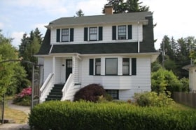
Floden House
https://search.heritageburnaby.ca/link/landmark524
- Repository
- Burnaby Heritage Planning
- Description
- The Floden House is a gambrel roofed, one and one-half storey plus basement wood-frame Dutch Colonial Revival residence, located at the head of the T-intersection of Fourth Street and Edmonds Street in a residential area of East Burnaby.
- Associated Dates
- 1929
- Formal Recognition
- Heritage Designation, Community Heritage Register
- Other Names
- Eric B. & Carrie Floden House
- Street View URL
- Google Maps Street View
- Repository
- Burnaby Heritage Planning
- Other Names
- Eric B. & Carrie Floden House
- Geographic Access
- 4th Street
- Associated Dates
- 1929
- Formal Recognition
- Heritage Designation, Community Heritage Register
- Enactment Type
- Bylaw No. 11358
- Enactment Date
- 27/05/2002
- Description
- The Floden House is a gambrel roofed, one and one-half storey plus basement wood-frame Dutch Colonial Revival residence, located at the head of the T-intersection of Fourth Street and Edmonds Street in a residential area of East Burnaby.
- Heritage Value
- Built in 1929 for Swedish emigrant Eric Birger Floden (1896-1971) and his Norwegian wife, Carrie (1899-1943), the Floden House is a valued representation of local middle-class housing from the 1920s, at a time of increasing prosperity just prior to the onset of the Great Depression. Eric Birger Floden was the head sawyer at Shook Mills in New Westminster, and his family occupied the house until 1964. Additionally, the Floden House is significant as an example of a residential pattern book design from the 1920s. With a reviving economy after the First World War, pattern books were widely used to expedite residential design and construction. It was built by Floden's brother in-law, Nels Olund, a talented contractor of the Fraser Valley who was experienced in building gambrel roof barns. The Floden House is also valued as an example of the Dutch Colonial Revival style, and is typical of period revival houses built in the 1920s that reflected the modern ideals of economy and good design as well as an ongoing pride in past traditions. It was presumed at the time that a well-built house would display a traditional and readily-identifiable style as a hallmark of good taste. The use of the various Colonial Revival styles had gained new popularity during the late 1920s at the time of the American Sesquicentennial. A local landmark, the house originally stood at 7997 18th Avenue and was moved two blocks to its current location by the City of Burnaby when it purchased and rehabilitated the house to save it from demolition, indicating the City's commitment to heritage conservation.
- Defining Elements
- Key elements that define the heritage character of the Floden House include its: - residential form, scale and massing as expressed by its one and one-half storey plus basement height, rectangular plan and distinctive roof form - Dutch Colonial Revival style details such as its side gambrel roof, front and rear shed dormers, attic fanlights, decorative shutters and regular fenestration - roof configuration, with overhanging eaves on the front facade with returns on the side facades, and clipped eaves on the side facades - asymmetrical front entry with small entry porch with lattice surrounds - front projecting bay window - wide lapped horizontal cedar siding - irregular fenestration, with original double-hung 6-over-1 wooden-sash windows - secondary side entry with balcony over - internal red brick chimney with concrete chimney caps
- Historic Neighbourhood
- East Burnaby (Historic Neighbourhood)
- Planning Study Area
- Edmonds Area
- Builder
- Nels Olund
- Function
- Primary Historic--Single Dwelling
- Primary Current--Single Dwelling
- Community
- Burnaby
- Cadastral Identifier
- 009-931-490
- Boundaries
- The Floden House is comprised of a single residential lot located at 7244 Fourth Street, Burnaby.
- Area
- 804.13
- Contributing Resource
- Building
- Ownership
- Private
- Street Address
- 7244 4th Street
- Street View URL
- Google Maps Street View
Images
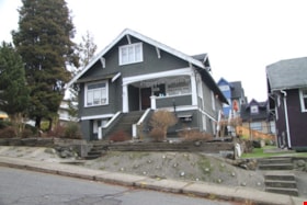
François & Cezarie Comeau Residence
https://search.heritageburnaby.ca/link/landmark580
- Repository
- Burnaby Heritage Planning
- Description
- Residential building.
- Associated Dates
- c.1925
- Street View URL
- Google Maps Street View
- Repository
- Burnaby Heritage Planning
- Geographic Access
- Esmond Avenue
- Associated Dates
- c.1925
- Description
- Residential building.
- Heritage Value
- This home was built for Francois Xavier “Frank” Comeau (1863-1943), a blacksmith who moved from Quebec to Vancouver in about 1890, and his wife Cezarie Marie (née Fortin, 1860-1950), also from Quebec, whom he married in 1903. Featuring a front gabled roof with decorative triangular eave brackets, this comfortable Craftsman bungalow displays other characteristics typical of the style such as lapped siding at the foundation, a shingle-clad main floor, casement windows and stained glass transoms on the front elevation. The most notable feature of the plan is the inset verandah with subtle segmental-arched openings and tapered square columns.
- Locality
- Vancouver Heights
- Historic Neighbourhood
- Vancouver Heights (Historic Neighbourhood)
- Planning Study Area
- Burnaby Heights Area
- Area
- 566.71
- Contributing Resource
- Building
- Ownership
- Private
- Street Address
- 306 Esmond Avenue
- Street View URL
- Google Maps Street View
Images
George & Rose Nuttall Residence
https://search.heritageburnaby.ca/link/landmark585
- Repository
- Burnaby Heritage Planning
- Description
- Residential building.
- Associated Dates
- 1921
- Other Names
- HILLCREST
- Street View URL
- Google Maps Street View
- Repository
- Burnaby Heritage Planning
- Other Names
- HILLCREST
- Geographic Access
- McGill Street
- Associated Dates
- 1921
- Description
- Residential building.
- Heritage Value
- This house was built for local plumber contractor George Nuttall (1883-1970) and his wife Rose Ann Nuttall (née Clagg, 1881-1955). George continued to live in the house after Rose’s death, until his own death in 1970. Although typical of the Craftsman style and form with its side-gabled roof, triangular eave brackets and front gabled dormer, this house has a number of special details, such as its beautiful art glass transom windows. The front verandah supports are massive stucco columns that contain stained glass lanterns with the house name, Hillcrest, and address.
- Locality
- Vancouver Heights
- Historic Neighbourhood
- Vancouver Heights (Historic Neighbourhood)
- Planning Study Area
- Burnaby Heights Area
- Area
- 566.71
- Contributing Resource
- Building
- Ownership
- Private
- Street Address
- 3756 McGill Street
- Street View URL
- Google Maps Street View
Images
Hastings Grove Neighbourhood
https://search.heritageburnaby.ca/link/landmark746
- Repository
- Burnaby Heritage Planning
- Associated Dates
- 1905-1924
- Heritage Value
- During the height of the real estate boom between 1909 and 1913, Vancouver developer Frederick Munson plotted the subdivision of more than 150 acres of land on Curtis Street east of Sperling Avenue, on the newly logged slopes of remote Burnaby Mountain. Burnaby opened up Curtis Street to facilitate access to Hastings Grove and Munson agreed to pay one-third of the cost but never did. He also paid only $1000.00 down on the agreed price of the land. When he failed to make further payments, the mortgage holders foreclosed and re-sold the properties. People who had bought lots from Munson lost not only the land they though they owned, but also the money they had paid for it. Hastings Grove was a disaster. The converted automobile - which served as the bus - stopped running. The few houses and most of the lots reverted to the Municipality because of non-payment of taxes and are now part of Burnaby Mountain Park. The only remaining building is the old Hastings Grove Store which still stands as an apartment building.
- Historic Neighbourhood
- Lochdale (Historic Neighbourhood)
- Planning Study Area
- Lochdale Area
Images
John & Jessie MacLean Residence
https://search.heritageburnaby.ca/link/landmark608
- Repository
- Burnaby Heritage Planning
- Description
- Residential building.
- Associated Dates
- c.1926
- Street View URL
- Google Maps Street View
- Repository
- Burnaby Heritage Planning
- Geographic Access
- Pandora Street
- Associated Dates
- c.1926
- Description
- Residential building.
- Heritage Value
- This cottage illustrates the traditionalism of the interwar years, when domestic ideals were expressed through modest homes displaying period revival influences. Reflecting the influence of the British Arts and Crafts movement, it features a symmetrical plan, a side jerkin-headed roof, a gabled front dormer and twin-coursed shingle siding, and retains its original wooden-sash windows with unusual multi-paned upper sash. It was built for John R. and Jessie MacLean. The house was recently restored by the owners.
- Locality
- Vancouver Heights
- Historic Neighbourhood
- Vancouver Heights (Historic Neighbourhood)
- Planning Study Area
- Burnaby Heights Area
- Area
- 566.71
- Contributing Resource
- Building
- Ownership
- Private
- Street Address
- 3827 Pandora Street
- Street View URL
- Google Maps Street View
Images
Lochdale Neighbourhood
https://search.heritageburnaby.ca/link/landmark668
- Repository
- Burnaby Heritage Planning
- Associated Dates
- 1925-1954
- Heritage Value
- In the 1931 "Burnaby Year Book" the Lochdale neighbourhood is described as follows: "Lochdale…is situated at the intersection of the Hastings-Barnet road at the point where Sperling Avenue crosses…Situated at the intersection…there are an up to date service station and a general store, at which the Lochdale Post Office is situated. Immediately north of this is the seventy acres on which the Shell Oil Co. are to build an up-to-date refinery...On going south on Sperling Avenue can be found some lovely homes of the residents, all of which possess the most beautiful flower gardens, some of which are hobbies, and some being in the nature of a business. Others are engaged in chicken farming...while others find employment at the Barnet Mill about two miles east on the Hastings-Barnet Road."
- Historic Neighbourhood
- Lochdale (Historic Neighbourhood)
- Planning Study Area
- Lochdale Area
Images
Newhoven Residence
https://search.heritageburnaby.ca/link/landmark626
- Repository
- Burnaby Heritage Planning
- Description
- Residential building.
- Associated Dates
- 1923
- Street View URL
- Google Maps Street View
- Repository
- Burnaby Heritage Planning
- Geographic Access
- Smith Avenue
- Associated Dates
- 1923
- Description
- Residential building.
- Heritage Value
- This large house was built in 1923 and first owned by Casper Newhoven, who managed the Empire Transfer & Storage Co. from this address. It would appear his parents, Cornelius (1879-1959), a barber at Joe’s Place on Granville Street, and Catherina (1883-1981) and his brother Martin (1905-1935), a taxi driver for Main Taxis, also lived here. It is a well-maintained example of a Late Craftsman bungalow, and typical of the style it features a gabled roof, tapered verandah piers, multi-paned windows and stained glass sidelights. The round verandah columns are an unusual feature. The Newhovens had left this address by the time of Martin’s death in 1935.
- Locality
- Central Park
- Historic Neighbourhood
- Central Park (Historic Neighbourhood)
- Planning Study Area
- Garden Village Area
- Area
- 675.80
- Contributing Resource
- Building
- Ownership
- Private
- Street Address
- 5488 Smith Avenue
- Street View URL
- Google Maps Street View
Images
Rev. James Black Residence
https://search.heritageburnaby.ca/link/landmark632
- Repository
- Burnaby Heritage Planning
- Description
- Residential building.
- Associated Dates
- 1925
- Street View URL
- Google Maps Street View
- Repository
- Burnaby Heritage Planning
- Geographic Access
- Sussex Avenue
- Associated Dates
- 1925
- Description
- Residential building.
- Heritage Value
- This home was built as a retirement home for Baptist Missionary Reverend James Black and his family in 1925; the Black family resided in the home until the early 1970s. The Black Residence is a good example of the Period Revival movement that occurred between the two World Wars. At the time, it was considered good taste for a house to have an identifiable historical style. The Black Residence was likely designed by a local architect or built by a contractor using a pattern book plan, and the British Arts and Crafts influence was typical of many middle class homes of the period built in Burnaby. The house was originally located facing Sardis Street with a beautiful garden landscape that was lost when the house was relocated in 2005.
- Locality
- Central Park
- Historic Neighbourhood
- Central Park (Historic Neighbourhood)
- Planning Study Area
- Marlborough Area
- Area
- 639.00
- Contributing Resource
- Building
- Ownership
- Private
- Street Address
- 5688 Sussex Avenue
- Street View URL
- Google Maps Street View
Images
Rosser Elementary School
https://search.heritageburnaby.ca/link/landmark636
- Repository
- Burnaby Heritage Planning
- Description
- School building.
- Associated Dates
- 1923
- Other Names
- NORTH BURNABY HIGH SCHOOL
- Street View URL
- Google Maps Street View
- Repository
- Burnaby Heritage Planning
- Other Names
- NORTH BURNABY HIGH SCHOOL
- Geographic Access
- Pandora Street
- Associated Dates
- 1923
- Description
- School building.
- Heritage Value
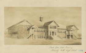
- Originally built as North Burnaby High School, this eight-room school became Rosser Avenue School in 1945. It has been altered with replacement windows, the application of stucco over the original siding and an addition, but has retained its historical form, including a hipped roof with half-timbered gables and a domed roof ventilator. The Rosser Elementary School was designed by the architectural firm of Bowman & Cullerne, who specialized in school design. The firm’s projects include Seaforth School (1922, now relocated to Burnaby Village Museum), Windsor Street School (1923), and Nelson Avenue School (1927).
- Locality
- Vancouver Heights
- Historic Neighbourhood
- Vancouver Heights (Historic Neighbourhood)
- Planning Study Area
- Burnaby Heights Area
- Architect
- Bowman and Cullerne
- Area
- 10579.94
- Contributing Resource
- Building
- Street Address
- 4375 Pandora Street
- Street View URL
- Google Maps Street View
Images
William & Annie Mawhinney Residence
https://search.heritageburnaby.ca/link/landmark654
- Repository
- Burnaby Heritage Planning
- Description
- Residential building.
- Associated Dates
- 1923
- Street View URL
- Google Maps Street View
- Repository
- Burnaby Heritage Planning
- Geographic Access
- Burris Street
- Associated Dates
- 1923
- Description
- Residential building.
- Heritage Value
- This bungalow was built by local farmer William Alexander Mawhinney (1870-1953) and Annie J. Mawhinney (1871-1956). This was one of several houses built in the immediate vicinity by members of the Mawhinney family between 1909 and 1930. William Mawhinney first came to Burnaby to help his brother Isaiah establish his fruit farm. In about 1930, William and Annie Mawhinney built a new house at 6011 Buckingham Avenue. This home is architecturally notable for its unusual front-gabled dormer, which is divided into parallel ridges at its peak. Though the original exterior wall siding has been covered by a later coat of stucco, it otherwise remains in largely original condition including double-hung windows with multi-paned upper sashes, front door with full-length sidelights and a decorative built-in window box.
- Locality
- Burnaby Lake
- Historic Neighbourhood
- Burnaby Lake (Historic Neighbourhood)
- Planning Study Area
- Morley-Buckingham Area
- Area
- 891.70
- Contributing Resource
- Building
- Ownership
- Private
- Street Address
- 7616 Burris Street
- Street View URL
- Google Maps Street View
Images
William & Edith Blott Residence
https://search.heritageburnaby.ca/link/landmark655
- Repository
- Burnaby Heritage Planning
- Description
- Residential building.
- Associated Dates
- 1923
- Street View URL
- Google Maps Street View
- Repository
- Burnaby Heritage Planning
- Geographic Access
- Laurel Street
- Associated Dates
- 1923
- Description
- Residential building.
- Heritage Value
- This elegant house is a prominent local landmark, with a bellcast hipped roof, deep bracketed eaves and Doric porch columns. The use of the various Colonial Revival styles had gained new popularity during the 1920s at the time of the American Sesquicentennial, as is evident in the symmetrical façade composition and detailing. It was the home of William Alexander Blott (1878-1962), a shipper at the Broder Canning Company and later a real estate agent, and his wife Edith Carruthers Blott (née Shaw, 1890-1972), who were married in 1913. It is one of the few remaining larger estate homes along the formerly rural Douglas Road.
- Locality
- Burnaby Lake
- Historic Neighbourhood
- Burnaby Lake (Historic Neighbourhood)
- Planning Study Area
- Douglas-Gilpin Area
- Area
- 1023.73
- Contributing Resource
- Building
- Ownership
- Private
- Street Address
- 5558 Laurel Street
- Street View URL
- Google Maps Street View
Images
William & Esther Burdick Residence
https://search.heritageburnaby.ca/link/landmark656
- Repository
- Burnaby Heritage Planning
- Description
- Residential building.
- Associated Dates
- 1925
- Other Names
- RYVERBRAE
- Street View URL
- Google Maps Street View
- Repository
- Burnaby Heritage Planning
- Other Names
- RYVERBRAE
- Geographic Access
- Buller Avenue
- Associated Dates
- 1925
- Description
- Residential building.
- Heritage Value
- This home was built in 1925 by William Leslie Burdick (1878-1937) and Esther Robina Burdick (née Armstrong, 1875-1964) who came to Burnaby from Manitoba to retire. Burdick was a prominent Winnipeg real estate agent; he retired in 1923, and contracted “Sleeping Sickness” the following year, which likely prompted a move to the more temperate west coast. Burdick became Reeve of Burnaby in 1929 and pressed for the development of the Deer Lake area as a great park featuring such amenities as a racetrack and water sports. During his tenure, this Craftsman-style home was regarded as a Burnaby showplace. He died in 1937 and Esther lived in this house until her own death in 1964. While the exterior of the house has been altered by a later coat of stucco over the original siding, it retains many original features such as its full-width verandah with tapered granite columns and piers, and stone-clad foundations and chimney.
- Locality
- Alta Vista
- Historic Neighbourhood
- Alta Vista (Historic Neighbourhood)
- Planning Study Area
- Clinton-Glenwood Area
- Area
- 1136.25
- Contributing Resource
- Building
- Ownership
- Private
- Street Address
- 7530 Buller Avenue
- Street View URL
- Google Maps Street View
Images
Windsor Street School
https://search.heritageburnaby.ca/link/landmark659
- Repository
- Burnaby Heritage Planning
- Description
- School building.
- Associated Dates
- 1924
- Street View URL
- Google Maps Street View
- Repository
- Burnaby Heritage Planning
- Geographic Access
- Imperial Street
- Associated Dates
- 1924
- Description
- School building.
- Heritage Value
- This school was built to replace Kingsway East School, which became part of Burnaby South High School. Architects Bowman & Cullerne designed the school in 1924; additions were made in 1927. The school features a distinctive double-height gabled entrance, a broad hipped roof and an octagonal rooftop ventilator. The Windsor Street School was designed by the architectural firm of Bowman & Cullerne, who specialized in school design. The firm’s projects include Seaforth School (1922, now relocated to Burnaby Village Museum), Burnaby North High School (1923), and Nelson Avenue School (1927).
- Locality
- Edmonds
- Historic Neighbourhood
- Edmonds (Historic Neighbourhood)
- Planning Study Area
- Windsor Area
- Architect
- Bowman & Cullerne
- Area
- 3716.12
- Contributing Resource
- Building
- Street Address
- 6166 Imperial Street
- Street View URL
- Google Maps Street View
Images
A.E. Brown Residence
https://search.heritageburnaby.ca/link/landmark553
- Repository
- Burnaby Heritage Planning
- Description
- Residential building.
- Associated Dates
- 1924
- Street View URL
- Google Maps Street View
- Repository
- Burnaby Heritage Planning
- Geographic Access
- Sperling Avenue
- Associated Dates
- 1924
- Description
- Residential building.
- Heritage Value
- Built after the end of the First World War, this house features an eclectic blend of Arts and Crafts elements. Constructed for A.E. Brown and a full two storeys in height, it has a front jerkin-headed roof with a jerkin-headed side projection, and a corner wraparound verandah with tapered columns. The house has been maintained in near original condition, with original lapped wooden siding, multi-paned windows and square balusters.
- Locality
- Edmonds
- Historic Neighbourhood
- Edmonds (Historic Neighbourhood)
- Planning Study Area
- Kingsway-Beresford Area
- Ownership
- Private
- Street Address
- 6830 Sperling Avenue
- Street View URL
- Google Maps Street View
Images
Burnaby Civic Employees Union Memorial Fountain
https://search.heritageburnaby.ca/link/landmark539
- Repository
- Burnaby Heritage Planning
- Description
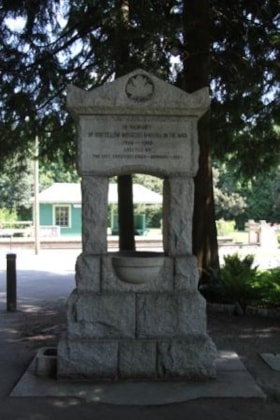
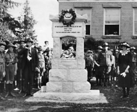
- This memorial granite drinking fountain is a monument to Burnaby’s municipal employees who lost their lives in the First World War. It has been relocated from its original setting to a shaded arterial pathway within the Burnaby Village Museum.
- Associated Dates
- 1923
- Formal Recognition
- Heritage Designation, Community Heritage Register
- Repository
- Burnaby Heritage Planning
- Geographic Access
- Deer Lake Avenue
- Associated Dates
- 1923
- Formal Recognition
- Heritage Designation, Community Heritage Register
- Enactment Type
- Bylaw No. 9807
- Enactment Date
- 23/11/1992
- Description
- This memorial granite drinking fountain is a monument to Burnaby’s municipal employees who lost their lives in the First World War. It has been relocated from its original setting to a shaded arterial pathway within the Burnaby Village Museum.
- Heritage Value
- The fountain is an early civic monument with superior massing and detail, constructed of local materials by local stonemason William Williamson. It was erected by the Burnaby Civic Employees Union (now CUPE Local 23) in 1923, on Burnaby’s original Municipal Hall grounds located at Kingsway and Edmonds Street, to honour their members who lost their lives in the First World War, commemorated by an engraved memorial at the top of the fountain. It signifies an important connection with the early strength and prominence of the civic labour union in Burnaby, as this was a memorial erected by the union members themselves, rather than by the civic government. Many war memorials were constructed across Canada after the end of the First World War, however, most are static, inviting passive contemplation. This memorial is unusual in its combination of functions; its use as a drinking fountain invites active participation. The memorial also includes a stone drinking bowl for dogs at the bottom left of the memorial, further illustrating the daily functional use of the fountain. The heritage value for this fountain also lies in its interpretive value within the Burnaby Village Museum. The site is an important cultural feature for the interpretation of Burnaby’s heritage to the public. The fountain was moved to the Burnaby Village Museum in 1974.
- Defining Elements
- The character defining features of the Burnaby Civic Employees Union Memorial Fountain include its: - distinctive form with central water fountain - construction of rough-dressed local B.C. granite - engraved memorial at the top - carved emblematic maple leaf - drinking fountain function - dog drinking bowl
- Locality
- Deer Lake Park
- Historic Neighbourhood
- Burnaby Lake (Historic Neighbourhood)
- Planning Study Area
- Morley-Buckingham Area
- Builder
- William Williamson
- Function
- Primary Current--Monument
- Primary Historic--Monument
- Secondary Current--Museum
- Community
- Burnaby
- Cadastral Identifier
- P.I.D. No. 011-030-356 Legal Description: Parcel 1, District Lot 79 and District Lot 85, Group 1, New Westminster District, Reference Plan 77594
- Boundaries
- Burnaby Village Museum is comprised of a single municipally-owned property located at 6501 Deer Lake Avenue, Burnaby.
- Area
- 38,488.63
- Contributing Resource
- Building
- Structure
- Landscape Feature
- Ownership
- Public (local)
- Documentation
- Heritage Site Files: PC77000 20. City of Burnaby Planning and Building Department, 4949 Canada Way, Burnaby, B.C., V5G 1M2
- Street Address
- 6501 Deer Lake Avenue
Images
Burnaby North High School
https://search.heritageburnaby.ca/link/landmark745
- Repository
- Burnaby Heritage Planning
- Associated Dates
- 1923-1982
- Street View URL
- Google Maps Street View
- Repository
- Burnaby Heritage Planning
- Geographic Access
- Willingdon Avenue
- Associated Dates
- 1923-1982
- Heritage Value
- Burnaby North and Burnaby South were the first high schools built in the City. Before the high school opened, Burnaby students had to travel to Vancouver if they wished to pursue education beyond an elementary level. In 1921, arrangements were made to use the basement of the Presbyterian Church for instruction of local students. By 1922 the Burnaby North High School opened at its first permanent location (4375 Pandora Street - which is now Rosser Elementary). In 1945, the Willingdon Avenue site was built and was used until a new building was constructed in 1961 on Hammarskjold Drive. From 1962, the school was used as Burnaby Heights Junior High school, but it closed in 1982 and the junior high students went to the new Burnaby North on Hammarskjold.
- Historic Neighbourhood
- Capitol Hill (Historic Neighbourhood)
- Planning Study Area
- Capitol Hill Area
- Street Address
- 250 Willingdon Avenue
- Street View URL
- Google Maps Street View
Images
Drs. Blythe and Violet Eagles Estate
https://search.heritageburnaby.ca/link/landmark535
- Repository
- Burnaby Heritage Planning
- Description
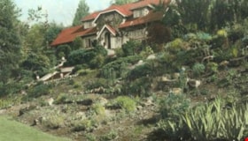
- The Drs. Blythe and Violet Eagles Estate is a one hectare property located within Deer Lake Park in Burnaby. The property encompasses a carefully conceived garden of local, non-conventional, and exotic plantings. Conceived as a series of rockeries and terraces, the garden cascades from the house do…
- Associated Dates
- 1929
- Formal Recognition
- Heritage Designation, Community Heritage Register
- Other Names
- Eagles Estate Heritage Garden
- Street View URL
- Google Maps Street View
- Repository
- Burnaby Heritage Planning
- Other Names
- Eagles Estate Heritage Garden
- Geographic Access
- Sperling Avenue
- Associated Dates
- 1929
- Formal Recognition
- Heritage Designation, Community Heritage Register
- Enactment Type
- Bylaw No. 11592
- Enactment Date
- 15/09/2003
- Description
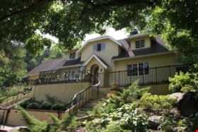
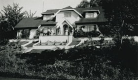
- The Drs. Blythe and Violet Eagles Estate is a one hectare property located within Deer Lake Park in Burnaby. The property encompasses a carefully conceived garden of local, non-conventional, and exotic plantings. Conceived as a series of rockeries and terraces, the garden cascades from the house down towards the waterfront, divided by paths and strips of plantings.
- Heritage Value
- The Eagles Estate is significant because of its unique character within Burnaby’s Deer Lake Park heritage precinct, and the people who were its creators and residents. The garden is a unique expression of the talents and tastes of both the Eagles and Frank Ebenezer Buck (1875-1970). Buck served as the Assistant Dominion Horticulturist in charge of landscape horticulture and floriculture in Ottawa from 1912. In 1920, he was head of the Horticultural Department and the Campus Landscape Architect at the University of British Columbia. He established the plan for the Eagles garden while Dr. Blythe Alfred Eagles (1902-1990), the long-time Dean of the Faculty of Agriculture at UBC, selected many of the plantings. The Eagles themselves designed the house as a romantic cottage inspired by the British Arts and Crafts style. Trained in enzyme chemistry, Dr. Violet Evelyn (Dunbar) Eagles (1899-1994) was an enthusiastic amateur gardener, and was perhaps the driving force behind the maintenance and continued development of the garden. The Eagles were also well known in Burnaby for their active volunteerism in the local community as well as at UBC. When Simon Fraser University opened in Burnaby as the Greater Vancouver’s second university, the Eagles, in particular Violet, became well-known for entertaining dignitaries and special guests of the university in their lavish garden. Drs. Blythe and Violet Eagles were recognized for their good citizenship and the ongoing use of their garden for charitable Burnaby-based functions and celebrations.
- Defining Elements
- Due to the extensive and varied nature of the garden, the character-defining elements of the Eagles Estate are many and complex. The elements that encompass the character of the site include its: - British Arts and Crafts-inspired house with original exterior features such as a picturesque roofline, stucco cladding and six- and eight-paned steel-frame casement windows, and original interior features such as the central fireplace, wood floors and kitchen cabinetry - formal staircase leading to the north (formal entry) side of the house - carefully planned yet informal garden design, with 'garden rooms' used to create intimacy - terraced landscape cascading from the house down to the garden - incorporation of local, exotic, flowering and non-flowering plants. - contrast of manicured versus freely growing landscape elements - use of wood lattice fencing gates, arbors and trellis
- Historic Neighbourhood
- Burnaby Lake (Historic Neighbourhood)
- Planning Study Area
- Morley-Buckingham Area
- Community
- Burnaby
- Cadastral Identifier
- P.I.D. No. 007-302-801 Legal Description: Lot 143, District Lot 85, Group 1, New Westminster District, Plan 36335
- Boundaries
- The Eagles Estate is comprised of a single municipally-owned property located at 5655 Sperling Avenue, Burnaby.
- Area
- 6,403.91
- Contributing Resource
- Building
- Landscape Feature
- Documentation
- Heritage Site Files: PC77000 20. City of Burnaby Planning and Building Department, 4949 Canada Way, Burnaby, B.C., V5G 1M2
- Street Address
- 5655 Sperling Avenue
- Street View URL
- Google Maps Street View
Images
East Burnaby Neighbourhood
https://search.heritageburnaby.ca/link/landmark773
- Repository
- Burnaby Heritage Planning
- Associated Dates
- 1905-1924
- Heritage Value
- According to the 1911 December 26 edition of The British Columbian: Optimism is the word that applies to the whole community of East Burnaby. The many improvements carried out by the council during the past two years had been the means of making East Burnaby a thriving settlement, and hence one and all are optimistic as to its future. In the clearing and building line, many fine new homes are being erected...Real estate values have advanced with the times, and a notable feature is the number of better-class houses that are being built in this locality, which proves that East Burnaby is becoming very much alive and elevated.
- Historic Neighbourhood
- East Burnaby (Historic Neighbourhood)
- Planning Study Area
- Edmonds Area
