Narrow Results By
Subject
- Advertising Medium - Signs and Signboards 4
- Agriculture - Farms 5
- Agriculture - Poultry 1
- Animals - Cats 1
- Animals - Dogs 5
- Animals - Goats 1
- Animals - Poultry 1
- Buildings - Agricultural 1
- Buildings - Agricultural - Barns 2
- Buildings - Civic - Museums 1
- Buildings - Commercial - Restaurants 1
- Buildings - Commercial - Stores 2
![311 Madison Avenue, [1925] (date of original), copied 1991 thumbnail](/media/hpo/_Data/_Archives_Images/_Unrestricted/370/370-210.jpg?width=280)
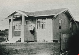
311 Madison Avenue
https://search.heritageburnaby.ca/link/archivedescription37622
- Repository
- City of Burnaby Archives
- Date
- [1925] (date of original), copied 1991
- Collection/Fonds
- Burnaby Historical Society fonds
- Description Level
- Item
- Physical Description
- 1 photograph : b&w ; 2.9 x 4.5 cm print on contact sheet 20.2 x 25.3 cm
- Scope and Content
- Photograph of the exterior of 311 Madison Avenue.
- Repository
- City of Burnaby Archives
- Date
- [1925] (date of original), copied 1991
- Collection/Fonds
- Burnaby Historical Society fonds
- Subseries
- Burnaby Image Bank subseries
- Physical Description
- 1 photograph : b&w ; 2.9 x 4.5 cm print on contact sheet 20.2 x 25.3 cm
- Description Level
- Item
- Record No.
- 370-210
- Access Restriction
- No restrictions
- Reproduction Restriction
- No known restrictions
- Accession Number
- BHS1999-03
- Scope and Content
- Photograph of the exterior of 311 Madison Avenue.
- Subjects
- Buildings - Residential - Houses
- Media Type
- Photograph
- Notes
- Title based on contents of photograph
- 1 b&w copy negative accompanying
- Geographic Access
- Madison Avenue
- Street Address
- 311 Madison Avenue
- Historic Neighbourhood
- Vancouver Heights (Historic Neighbourhood)
- Planning Study Area
- Burnaby Heights Area
Images
![311 Madison Avenue, [1925] (date of original), copied 1991 thumbnail](/media/hpo/_Data/_Archives_Images/_Unrestricted/370/370-210.jpg)
![805 Grove Avenue, [1925] (date of original), copied 1991 thumbnail](/media/hpo/_Data/_Archives_Images/_Unrestricted/370/370-274.jpg?width=280)
805 Grove Avenue
https://search.heritageburnaby.ca/link/archivedescription37686
- Repository
- City of Burnaby Archives
- Date
- [1925] (date of original), copied 1991
- Collection/Fonds
- Burnaby Historical Society fonds
- Description Level
- Item
- Physical Description
- 1 photograph : b&w ; 2.9 x 5.0 cm print on contact sheet 20.2 x 25.3 cm
- Scope and Content
- Photograph of the exterior of the house at 805 Grove Avenue.
- Repository
- City of Burnaby Archives
- Date
- [1925] (date of original), copied 1991
- Collection/Fonds
- Burnaby Historical Society fonds
- Subseries
- Burnaby Image Bank subseries
- Physical Description
- 1 photograph : b&w ; 2.9 x 5.0 cm print on contact sheet 20.2 x 25.3 cm
- Description Level
- Item
- Record No.
- 370-274
- Access Restriction
- No restrictions
- Reproduction Restriction
- No known restrictions
- Accession Number
- BHS1999-03
- Scope and Content
- Photograph of the exterior of the house at 805 Grove Avenue.
- Subjects
- Buildings - Residential - Houses
- Media Type
- Photograph
- Notes
- Title based on contents of photograph
- 1 b&w copy negative accompanying
- Negative has a pink cast
- Geographic Access
- Grove Avenue
- Street Address
- 805 Grove Avenue
- Historic Neighbourhood
- Lochdale (Historic Neighbourhood)
- Planning Study Area
- Lochdale Area
Images
![805 Grove Avenue, [1925] (date of original), copied 1991 thumbnail](/media/hpo/_Data/_Archives_Images/_Unrestricted/370/370-274.jpg)
![2700 Block Willingdon Avenue, [1928] (date of original), copied 1991 thumbnail](/media/hpo/_Data/_Archives_Images/_Unrestricted/370/370-105.jpg?width=280)
2700 Block Willingdon Avenue
https://search.heritageburnaby.ca/link/archivedescription37517
- Repository
- City of Burnaby Archives
- Date
- [1928] (date of original), copied 1991
- Collection/Fonds
- Burnaby Historical Society fonds
- Description Level
- Item
- Physical Description
- 1 photograph : b&w ; 4.5 x 2.6 cm print on contact sheet 20.3 x 25.3 cm
- Scope and Content
- Photograph of neighbours of the Murley family on the 2700 block of Willingdon Avenue (later renumbered as the 6300 block of Willingdon Avenue). A woman and two children are standing in front of a house.
- Repository
- City of Burnaby Archives
- Date
- [1928] (date of original), copied 1991
- Collection/Fonds
- Burnaby Historical Society fonds
- Subseries
- Burnaby Image Bank subseries
- Physical Description
- 1 photograph : b&w ; 4.5 x 2.6 cm print on contact sheet 20.3 x 25.3 cm
- Description Level
- Item
- Record No.
- 370-105
- Access Restriction
- No restrictions
- Reproduction Restriction
- No known restrictions
- Accession Number
- BHS1999-03
- Scope and Content
- Photograph of neighbours of the Murley family on the 2700 block of Willingdon Avenue (later renumbered as the 6300 block of Willingdon Avenue). A woman and two children are standing in front of a house.
- Subjects
- Buildings - Residential - Houses
- Media Type
- Photograph
- Notes
- Title based on contents of photograph
- 1 b&w copy negative accompanying
- Geographic Access
- Willingdon Avenue
- Historic Neighbourhood
- Central Park (Historic Neighbourhood)
- Planning Study Area
- Maywood Area
Images
![2700 Block Willingdon Avenue, [1928] (date of original), copied 1991 thumbnail](/media/hpo/_Data/_Archives_Images/_Unrestricted/370/370-105.jpg)

3955 Moscrop Street
https://search.heritageburnaby.ca/link/archivedescription98654
- Repository
- City of Burnaby Archives
- Date
- 2021
- Collection/Fonds
- Disappearing Burnaby collection
- Description Level
- Item
- Physical Description
- 1 photograph (jpeg) : col.
- Scope and Content
- Photograph of the exterior of a house located at 3955 Moscrop Street. The house was constructed in 1954. The photograph depicts the house at night, with the house's porch light on, and a car is in the driveway in front of the house.
- Repository
- City of Burnaby Archives
- Date
- 2021
- Collection/Fonds
- Disappearing Burnaby collection
- Physical Description
- 1 photograph (jpeg) : col.
- Description Level
- Item
- Record No.
- 634-001
- Access Restriction
- No restrictions
- Reproduction Restriction
- No restrictions
- Accession Number
- 2022-14
- Scope and Content
- Photograph of the exterior of a house located at 3955 Moscrop Street. The house was constructed in 1954. The photograph depicts the house at night, with the house's porch light on, and a car is in the driveway in front of the house.
- Media Type
- Photograph
- Photographer
- Cheung, Nakita
- Notes
- Title taken from the associated blog post
- Associated blog post: https://disappearingburnaby.wordpress.com/2022/02/24/moscrop-house/
- Geographic Access
- Moscrop Street
- Street Address
- 3955 Moscrop Street
- Historic Neighbourhood
- Broadview (Historic Neighbourhood)
- Planning Study Area
- Cascade-Schou Area
Images


5130 Irving Street
https://search.heritageburnaby.ca/link/archivedescription98671
- Repository
- City of Burnaby Archives
- Date
- 2022
- Collection/Fonds
- Disappearing Burnaby collection
- Description Level
- Item
- Physical Description
- 1 photograph (jpeg) : col.
- Scope and Content
- Photograph of the front steps and the entrance of a three-storey apartment building located at 5130 Irving Street. The photograph depicts the building at night, with the lobby and some of the apartments' windows illuminated from inside. The building was constructed in 1971.
- Repository
- City of Burnaby Archives
- Date
- 2022
- Collection/Fonds
- Disappearing Burnaby collection
- Physical Description
- 1 photograph (jpeg) : col.
- Description Level
- Item
- Record No.
- 634-018
- Access Restriction
- No restrictions
- Reproduction Restriction
- No restrictions
- Accession Number
- 2022-14
- Scope and Content
- Photograph of the front steps and the entrance of a three-storey apartment building located at 5130 Irving Street. The photograph depicts the building at night, with the lobby and some of the apartments' windows illuminated from inside. The building was constructed in 1971.
- Media Type
- Photograph
- Photographer
- Cheung, Nakita
- Notes
- Title taken from the associated blog post
- Associated blog post: https://disappearingburnaby.wordpress.com/2022/05/04/e-just-e/
- Geographic Access
- Irving Street
- Street Address
- 5130 Irving Street
- Historic Neighbourhood
- Central Park (Historic Neighbourhood)
- Planning Study Area
- Marlborough Area
Images


5130 Irving Street lobby
https://search.heritageburnaby.ca/link/archivedescription98672
- Repository
- City of Burnaby Archives
- Date
- 2022
- Collection/Fonds
- Disappearing Burnaby collection
- Description Level
- Item
- Physical Description
- 1 photograph (jpeg) : col.
- Scope and Content
- Photograph of the entrance of an apartment building located at 5130 Irving Street. The building was constructed in 1971. The photograph depicts the entrance and the lobby from the exterior at night. The lobby is illuminated and a crest featuring an "E" is on the entrance window.
- Repository
- City of Burnaby Archives
- Date
- 2022
- Collection/Fonds
- Disappearing Burnaby collection
- Physical Description
- 1 photograph (jpeg) : col.
- Description Level
- Item
- Record No.
- 634-019
- Access Restriction
- No restrictions
- Reproduction Restriction
- No restrictions
- Accession Number
- 2022-14
- Scope and Content
- Photograph of the entrance of an apartment building located at 5130 Irving Street. The building was constructed in 1971. The photograph depicts the entrance and the lobby from the exterior at night. The lobby is illuminated and a crest featuring an "E" is on the entrance window.
- Media Type
- Photograph
- Photographer
- Cheung, Nakita
- Notes
- Title taken from the associated blog post
- Associated blog post: https://disappearingburnaby.wordpress.com/2022/05/04/e-just-e/
- Geographic Access
- Irving Street
- Street Address
- 5130 Irving Street
- Historic Neighbourhood
- Central Park (Historic Neighbourhood)
- Planning Study Area
- Marlborough Area
Images


5990 Irmin Street
https://search.heritageburnaby.ca/link/archivedescription98685
- Repository
- City of Burnaby Archives
- Date
- 2022
- Collection/Fonds
- Disappearing Burnaby collection
- Description Level
- Item
- Physical Description
- 1 photograph (jpeg) : col.
- Scope and Content
- Photograph of a multi-storey house located at 5990 Irmin Street. The photograph depicts of the exterior of the house at dusk; a light is on in one of the house's rooms and a vehicle is parked in the house's driveway next to a portable garage. A "For Sale" sign on the edge of the property reads: "Fu…
- Repository
- City of Burnaby Archives
- Date
- 2022
- Collection/Fonds
- Disappearing Burnaby collection
- Physical Description
- 1 photograph (jpeg) : col.
- Description Level
- Item
- Record No.
- 634-032
- Access Restriction
- No restrictions
- Reproduction Restriction
- No restrictions
- Accession Number
- 2022-14
- Scope and Content
- Photograph of a multi-storey house located at 5990 Irmin Street. The photograph depicts of the exterior of the house at dusk; a light is on in one of the house's rooms and a vehicle is parked in the house's driveway next to a portable garage. A "For Sale" sign on the edge of the property reads: "Future Development Land." Another house is visible in the background. The house was constructed in 1923 and is nearby to 7530 Buller Avenue.
- Media Type
- Photograph
- Photographer
- Cheung, Nakita
- Notes
- Title taken from the associated blog post
- Associated blog post: https://disappearingburnaby.wordpress.com/2022/06/30/william-esther-burdick-residence/
- Geographic Access
- Irmin Street
- Street Address
- 5990 Irmin Street
- Historic Neighbourhood
- Alta Vista (Historic Neighbourhood)
- Planning Study Area
- Clinton-Glenwood Area
Images


6280 Marlborough Avenue
https://search.heritageburnaby.ca/link/archivedescription98673
- Repository
- City of Burnaby Archives
- Date
- 2022
- Collection/Fonds
- Disappearing Burnaby collection
- Description Level
- Item
- Physical Description
- 1 photograph (jpeg) : col.
- Scope and Content
- Photograph of the front steps and entry to a three-storey apartment building, located at 6280 Marlborough Avenue. The photograph depicts the building at night and shows the brick building's details, including its lion statues and busts along the stair railings and the curved arches in front of the …
- Repository
- City of Burnaby Archives
- Date
- 2022
- Collection/Fonds
- Disappearing Burnaby collection
- Physical Description
- 1 photograph (jpeg) : col.
- Description Level
- Item
- Record No.
- 634-020
- Access Restriction
- No restrictions
- Reproduction Restriction
- No restrictions
- Accession Number
- 2022-14
- Scope and Content
- Photograph of the front steps and entry to a three-storey apartment building, located at 6280 Marlborough Avenue. The photograph depicts the building at night and shows the brick building's details, including its lion statues and busts along the stair railings and the curved arches in front of the front windows and door. The building was constructed in 1973.
- Media Type
- Photograph
- Photographer
- Cheung, Nakita
- Notes
- Title taken from the associated blog post
- Associated blog post: https://disappearingburnaby.wordpress.com/2022/05/12/marlborough-ave/
- Geographic Access
- Marlborough Avenue
- Street Address
- 6280 Marlborough Avenue
- Historic Neighbourhood
- Central Park (Historic Neighbourhood)
- Planning Study Area
- Marlborough Area
Images


6410 Denbigh Avenue
https://search.heritageburnaby.ca/link/archivedescription98667
- Repository
- City of Burnaby Archives
- Date
- 2022
- Collection/Fonds
- Disappearing Burnaby collection
- Description Level
- Item
- Physical Description
- 1 photograph (jpeg) : col.
- Scope and Content
- Photograph of the exterior of a single-storey house located at 6410 Denbigh Avenue, taken from across the street at dusk. The house was constructed in 1949. Lights illuminate the front porch and the interior of one of the house's windows and there is a small amount of snow on the lawn in front of t…
- Repository
- City of Burnaby Archives
- Date
- 2022
- Collection/Fonds
- Disappearing Burnaby collection
- Physical Description
- 1 photograph (jpeg) : col.
- Description Level
- Item
- Record No.
- 634-014
- Access Restriction
- No restrictions
- Reproduction Restriction
- No restrictions
- Accession Number
- 2022-14
- Scope and Content
- Photograph of the exterior of a single-storey house located at 6410 Denbigh Avenue, taken from across the street at dusk. The house was constructed in 1949. Lights illuminate the front porch and the interior of one of the house's windows and there is a small amount of snow on the lawn in front of the house.
- Media Type
- Photograph
- Photographer
- Cheung, Nakita
- Notes
- Title taken from the associated blog post
- Associated blog post: https://disappearingburnaby.wordpress.com/2022/05/15/denbigh-ave/
- Geographic Access
- Denbigh Avenue
- Street Address
- 6410 Denbigh Avenue
- Historic Neighbourhood
- Central Park (Historic Neighbourhood)
- Planning Study Area
- Windsor Area
Images


6508 Silver Avenue
https://search.heritageburnaby.ca/link/archivedescription98678
- Repository
- City of Burnaby Archives
- Date
- 2022
- Collection/Fonds
- Disappearing Burnaby collection
- Description Level
- Item
- Physical Description
- 1 photograph (jpeg) : col.
- Scope and Content
- Photograph of the corner and side of the exterior of a concrete low-rise apartment building located at 6508 Silver Avenue. The photograph depicts the building at dusk. Some of the apartment windows are lit up from inside, and plant pots are lined up along the third-floor balcony. A chain link fence…
- Repository
- City of Burnaby Archives
- Date
- 2022
- Collection/Fonds
- Disappearing Burnaby collection
- Physical Description
- 1 photograph (jpeg) : col.
- Description Level
- Item
- Record No.
- 634-025
- Access Restriction
- No restrictions
- Reproduction Restriction
- No restrictions
- Accession Number
- 2022-14
- Scope and Content
- Photograph of the corner and side of the exterior of a concrete low-rise apartment building located at 6508 Silver Avenue. The photograph depicts the building at dusk. Some of the apartment windows are lit up from inside, and plant pots are lined up along the third-floor balcony. A chain link fence surrounds the backyard. The building was constructed in 1966.
- Media Type
- Photograph
- Photographer
- Cheung, Nakita
- Notes
- Title taken from the associated blog post
- Associated blog post: https://disappearingburnaby.wordpress.com/2022/06/30/brutalist/
- Geographic Access
- Silver Avenue
- Street Address
- 6508 Silver Avenue
- Historic Neighbourhood
- Central Park (Historic Neighbourhood)
- Planning Study Area
- Maywood Area
Images


6615 Telford Avenue
https://search.heritageburnaby.ca/link/archivedescription98674
- Repository
- City of Burnaby Archives
- Date
- 2022
- Collection/Fonds
- Disappearing Burnaby collection
- Description Level
- Item
- Physical Description
- 1 photograph (jpeg) : col.
- Scope and Content
- Photograph of the entrance, including the front steps and ramp, to a low-rise apartment building located at 6615 Telford Avenue. The building was constructed in 1964. The photograph depicts the building at night, and trees and bushes partially obscure the entrance. The building's lobby is illuminat…
- Repository
- City of Burnaby Archives
- Date
- 2022
- Collection/Fonds
- Disappearing Burnaby collection
- Physical Description
- 1 photograph (jpeg) : col.
- Description Level
- Item
- Record No.
- 634-021
- Access Restriction
- No restrictions
- Reproduction Restriction
- No restrictions
- Accession Number
- 2022-14
- Scope and Content
- Photograph of the entrance, including the front steps and ramp, to a low-rise apartment building located at 6615 Telford Avenue. The building was constructed in 1964. The photograph depicts the building at night, and trees and bushes partially obscure the entrance. The building's lobby is illuminated and the apartments' mailboxes are visible through the window.
- Media Type
- Photograph
- Photographer
- Cheung, Nakita
- Notes
- Title taken from the associated blog post
- Associated blog post: https://disappearingburnaby.wordpress.com/2022/06/09/martello-group/
- Geographic Access
- Telford Avenue
- Street Address
- 6615 Telford Avenue
- Historic Neighbourhood
- Central Park (Historic Neighbourhood)
- Planning Study Area
- Maywood Area
Images


6692 Dow Avenue
https://search.heritageburnaby.ca/link/archivedescription98662
- Repository
- City of Burnaby Archives
- Date
- 2022
- Collection/Fonds
- Disappearing Burnaby collection
- Description Level
- Item
- Physical Description
- 1 photograph (jpeg) : col.
- Scope and Content
- Photograph of the exterior of a two-storey apartment building located at 6692 Dow Avenue. The photograph depicts the building from across the street at night; the lobby and some of the apartment windows are lit up, with a bunch of balloons in one window, and a car is parked on the street in front o…
- Repository
- City of Burnaby Archives
- Date
- 2022
- Collection/Fonds
- Disappearing Burnaby collection
- Physical Description
- 1 photograph (jpeg) : col.
- Description Level
- Item
- Record No.
- 634-009
- Access Restriction
- No restrictions
- Reproduction Restriction
- No restrictions
- Accession Number
- 2022-14
- Scope and Content
- Photograph of the exterior of a two-storey apartment building located at 6692 Dow Avenue. The photograph depicts the building from across the street at night; the lobby and some of the apartment windows are lit up, with a bunch of balloons in one window, and a car is parked on the street in front of the building. The building was constructed in 1959.
- Media Type
- Photograph
- Photographer
- Cheung, Nakita
- Notes
- Title taken from the associated blog post
- Associated blog post: https://disappearingburnaby.wordpress.com/2022/03/01/dow-ave/
- Geographic Access
- Dow Avenue
- Street Address
- 6692 Dow Avenue
- Historic Neighbourhood
- Central Park (Historic Neighbourhood)
- Planning Study Area
- Maywood Area
Images


6700 Dow Avenue
https://search.heritageburnaby.ca/link/archivedescription98663
- Repository
- City of Burnaby Archives
- Date
- 2022
- Collection/Fonds
- Disappearing Burnaby collection
- Description Level
- Item
- Physical Description
- 1 photograph (jpeg) : col.
- Scope and Content
- Photograph of the entrance to an apartment building located at 6700 Dow Avenue. The photograph depicts the building at night; the lobby and stairs are illuminated by exterior and interior lights. The building was constructed in 1968.
- Repository
- City of Burnaby Archives
- Date
- 2022
- Collection/Fonds
- Disappearing Burnaby collection
- Physical Description
- 1 photograph (jpeg) : col.
- Description Level
- Item
- Record No.
- 634-010
- Access Restriction
- No restrictions
- Reproduction Restriction
- No restrictions
- Accession Number
- 2022-14
- Scope and Content
- Photograph of the entrance to an apartment building located at 6700 Dow Avenue. The photograph depicts the building at night; the lobby and stairs are illuminated by exterior and interior lights. The building was constructed in 1968.
- Media Type
- Photograph
- Photographer
- Cheung, Nakita
- Notes
- Title taken from the associated blog post
- Associated blog post: https://disappearingburnaby.wordpress.com/2022/03/29/no-pes/
- Geographic Access
- Dow Avenue
- Street Address
- 6700 Dow Avenue
- Historic Neighbourhood
- Central Park (Historic Neighbourhood)
- Planning Study Area
- Maywood Area
Images


7530 Buller Avenue
https://search.heritageburnaby.ca/link/archivedescription98686
- Repository
- City of Burnaby Archives
- Date
- 2022
- Collection/Fonds
- Disappearing Burnaby collection
- Description Level
- Item
- Physical Description
- 1 photograph (jpeg) : col.
- Scope and Content
- Photograph of the exterior of a two-storey house located at 7530 Buller Avenue. The photograph depicts the house at dusk; the house stands behind a wooden fence and is surrounded by trees. The house was constructed in 1924 and was formerly known as "Ryverbrae," the William & Esther Burdick Residenc…
- Repository
- City of Burnaby Archives
- Date
- 2022
- Collection/Fonds
- Disappearing Burnaby collection
- Physical Description
- 1 photograph (jpeg) : col.
- Description Level
- Item
- Record No.
- 634-033
- Access Restriction
- No restrictions
- Reproduction Restriction
- No restrictions
- Accession Number
- 2022-14
- Scope and Content
- Photograph of the exterior of a two-storey house located at 7530 Buller Avenue. The photograph depicts the house at dusk; the house stands behind a wooden fence and is surrounded by trees. The house was constructed in 1924 and was formerly known as "Ryverbrae," the William & Esther Burdick Residence.
- Media Type
- Photograph
- Photographer
- Cheung, Nakita
- Notes
- Title taken from the associated blog post
- Associated blog post: https://disappearingburnaby.wordpress.com/2022/06/30/william-esther-burdick-residence/
- Geographic Access
- Buller Avenue
- Street Address
- 7530 Buller Avenue
- Historic Neighbourhood
- Alta Vista (Historic Neighbourhood)
- Planning Study Area
- Clinton-Glenwood Area
Images

![Allanson family home, [192-] (date of original), copied 1986 thumbnail](/media/hpo/_Data/_Archives_Images/_Unrestricted/204/204-652.jpg?width=280)
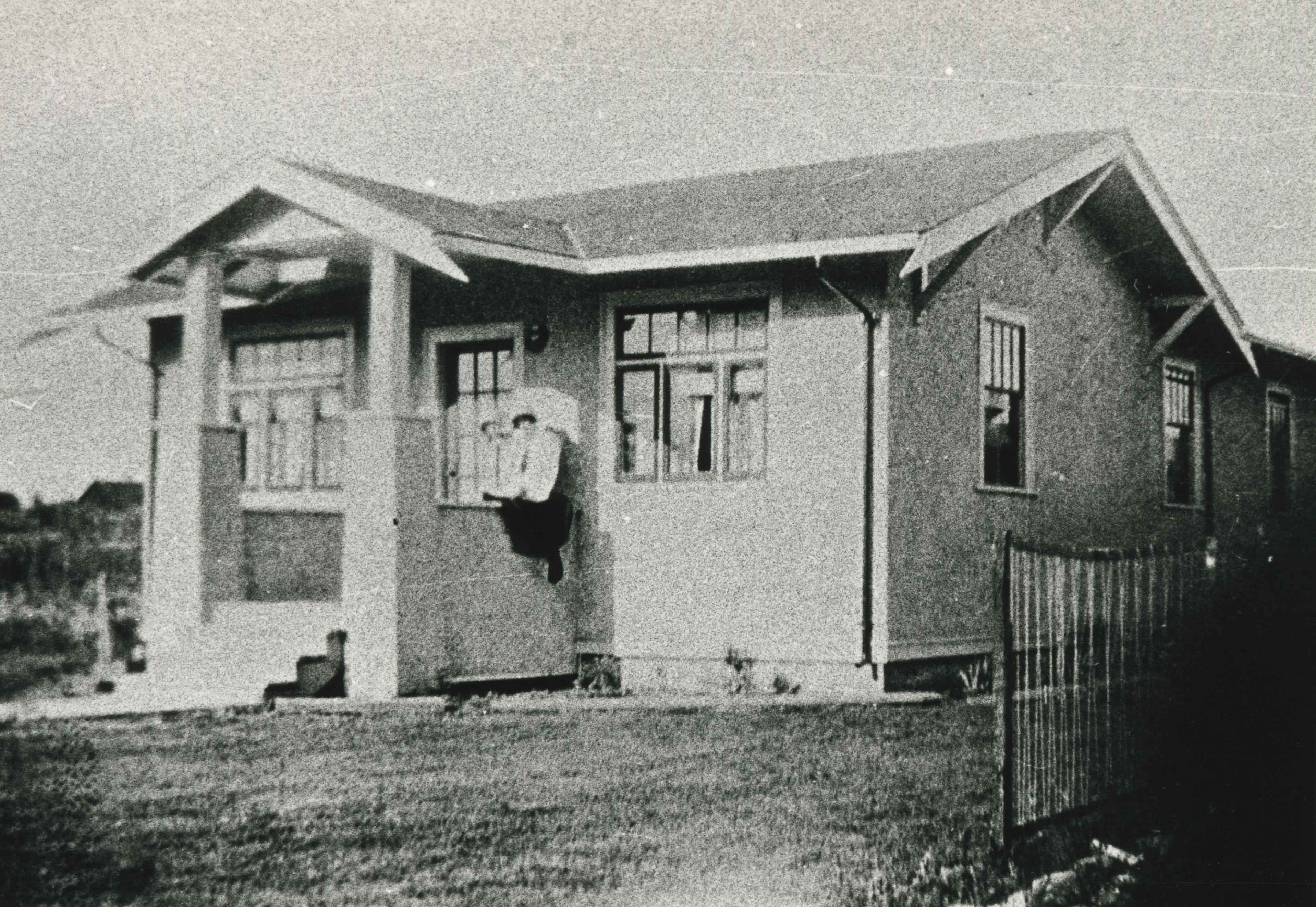
Allanson family home
https://search.heritageburnaby.ca/link/archivedescription35794
- Repository
- City of Burnaby Archives
- Date
- [192-] (date of original), copied 1986
- Collection/Fonds
- Burnaby Historical Society fonds
- Description Level
- Item
- Physical Description
- 1 photograph : b&w ; 12.7 x 17.8 cm print
- Scope and Content
- Photograph of the Allanson family home, 12 Warwick Avenue, Capitol Hill, North Burnaby.
- Repository
- City of Burnaby Archives
- Date
- [192-] (date of original), copied 1986
- Collection/Fonds
- Burnaby Historical Society fonds
- Subseries
- Pioneer Tales subseries
- Physical Description
- 1 photograph : b&w ; 12.7 x 17.8 cm print
- Description Level
- Item
- Record No.
- 204-652
- Access Restriction
- No restrictions
- Reproduction Restriction
- No known restrictions
- Accession Number
- BHS1988-03
- Scope and Content
- Photograph of the Allanson family home, 12 Warwick Avenue, Capitol Hill, North Burnaby.
- Media Type
- Photograph
- Notes
- Title based on contents of photograph
- Geographic Access
- Warwick Avenue
- Street Address
- 12 Warwick Avenue
- Historic Neighbourhood
- Capitol Hill (Historic Neighbourhood)
- Planning Study Area
- Capitol Hill Area
Images
![Allanson family home, [192-] (date of original), copied 1986 thumbnail](/media/hpo/_Data/_Archives_Images/_Unrestricted/204/204-652.jpg)

Armitage family home
https://search.heritageburnaby.ca/link/archivedescription35775
- Repository
- City of Burnaby Archives
- Date
- 1920 (date of original), copied 1986
- Collection/Fonds
- Burnaby Historical Society fonds
- Description Level
- Item
- Physical Description
- 1 photograph : b&w ; 12.7 x 17.8 cm print
- Scope and Content
- Photograph of the Armitage family home at 3276 Grimmer Street (later renumbered 5496 Grimmer Street), on the corner of Grimmer and Kingsway in South Burnaby. This was the second Armitage home and the second house built on this lot, the first having burned down.
- Repository
- City of Burnaby Archives
- Date
- 1920 (date of original), copied 1986
- Collection/Fonds
- Burnaby Historical Society fonds
- Subseries
- Pioneer Tales subseries
- Physical Description
- 1 photograph : b&w ; 12.7 x 17.8 cm print
- Description Level
- Item
- Record No.
- 204-633
- Access Restriction
- No restrictions
- Reproduction Restriction
- No known restrictions
- Accession Number
- BHS1988-03
- Scope and Content
- Photograph of the Armitage family home at 3276 Grimmer Street (later renumbered 5496 Grimmer Street), on the corner of Grimmer and Kingsway in South Burnaby. This was the second Armitage home and the second house built on this lot, the first having burned down.
- Subjects
- Buildings - Residential - Houses
- Media Type
- Photograph
- Notes
- Title based on contents of photograph
- Geographic Access
- Grimmer Street
- Street Address
- 5496 Grimmer Street
- Historic Neighbourhood
- Central Park (Historic Neighbourhood)
- Planning Study Area
- Windsor Area
Images

Armitage family home
https://search.heritageburnaby.ca/link/archivedescription35776
- Repository
- City of Burnaby Archives
- Date
- 1924 (date of original), copied 1986
- Collection/Fonds
- Burnaby Historical Society fonds
- Description Level
- Item
- Physical Description
- 1 photograph : b&w ; 12.7 x 17.8 cm print
- Scope and Content
- Photograph of the Armitage family home at 1925 Buller Avenue (later renumbered 7342 Buller Avenue) in the Highland Park area. This was the third Armitage home. Edna Armitage and Joe Rigby held their wedding reception here in 1931.
- Repository
- City of Burnaby Archives
- Date
- 1924 (date of original), copied 1986
- Collection/Fonds
- Burnaby Historical Society fonds
- Subseries
- Pioneer Tales subseries
- Physical Description
- 1 photograph : b&w ; 12.7 x 17.8 cm print
- Description Level
- Item
- Record No.
- 204-634
- Access Restriction
- No restrictions
- Reproduction Restriction
- No known restrictions
- Accession Number
- BHS1988-03
- Scope and Content
- Photograph of the Armitage family home at 1925 Buller Avenue (later renumbered 7342 Buller Avenue) in the Highland Park area. This was the third Armitage home. Edna Armitage and Joe Rigby held their wedding reception here in 1931.
- Subjects
- Buildings - Residential - Houses
- Media Type
- Photograph
- Notes
- Title based on contents of photograph
- Geographic Access
- Buller Avenue
- Street Address
- 7342 Buller Avenue
- Planning Study Area
- Clinton-Glenwood Area
Images
![Armitage family home, [192-] (date of original), copied 1986 thumbnail](/media/hpo/_Data/_Archives_Images/_Unrestricted/204/204-635.jpg?width=280)
Armitage family home
https://search.heritageburnaby.ca/link/archivedescription35777
- Repository
- City of Burnaby Archives
- Date
- [192-] (date of original), copied 1986
- Collection/Fonds
- Burnaby Historical Society fonds
- Description Level
- Item
- Physical Description
- 1 photograph : b&w ; 12.7 x 17.8 cm print
- Scope and Content
- Photograph of the Armitage family home at 3276 Buller Avenue (later renumbered 7342 Buller Avenue) in the Highland Park Area. This fourth Armitage family home was built by Albert Armitage and his brother. It was a much larger house than its predecessor on the same lot.
- Repository
- City of Burnaby Archives
- Date
- [192-] (date of original), copied 1986
- Collection/Fonds
- Burnaby Historical Society fonds
- Subseries
- Pioneer Tales subseries
- Physical Description
- 1 photograph : b&w ; 12.7 x 17.8 cm print
- Description Level
- Item
- Record No.
- 204-635
- Access Restriction
- No restrictions
- Reproduction Restriction
- No known restrictions
- Accession Number
- BHS1988-03
- Scope and Content
- Photograph of the Armitage family home at 3276 Buller Avenue (later renumbered 7342 Buller Avenue) in the Highland Park Area. This fourth Armitage family home was built by Albert Armitage and his brother. It was a much larger house than its predecessor on the same lot.
- Subjects
- Buildings - Residential - Houses
- Media Type
- Photograph
- Notes
- Title based on contents of photograph
- Geographic Access
- Buller Avenue
- Street Address
- 7342 Buller Avenue
- Planning Study Area
- Clinton-Glenwood Area
Images
![Armitage family home, [192-] (date of original), copied 1986 thumbnail](/media/hpo/_Data/_Archives_Images/_Unrestricted/204/204-635.jpg)

Barnet Lumber Company House
https://search.heritageburnaby.ca/link/landmark662
- Repository
- Burnaby Heritage Planning
- Description
- Residential building.
- Associated Dates
- 1925
- Street View URL
- Google Maps Street View
- Repository
- Burnaby Heritage Planning
- Geographic Access
- Texaco Drive
- Associated Dates
- 1925
- Description
- Residential building.
- Heritage Value
- This house is one of two surviving houses built as a “Model Home” for the manager of the Barnet Lumber Company, which was the successor to the North Pacific Lumber Company. It was used as a combined home and office. It was constructed with framing lumber and millwork sawn at the mill. Typical of the Craftsman style, the house has a front gabled roof with triangular eave brackets. It has been altered with the addition of asbestos shingles over the original siding, but retains its form, scale and massing. This house was designed by the firm of Townley & Matheson. The partnership of Fred Laughton Townley (1887-1966) and Robert Michael Matheson began in 1919, and the firm left a rich legacy of sophisticated work, including schools, commercial structures, many fine residences and the landmark Vancouver City Hall.
- Historic Neighbourhood
- Barnet (Historic Neighbourhood)
- Planning Study Area
- Burnaby Mountain Area
- Architect
- Townley & Matheson
- Area
- 2225.77
- Contributing Resource
- Building
- Ownership
- Public (local)
- Street Address
- 8007 Texaco Drive
- Street View URL
- Google Maps Street View
Images


Barnet Lumber Company House
https://search.heritageburnaby.ca/link/landmark663
- Repository
- Burnaby Heritage Planning
- Description
- Residential building.
- Associated Dates
- 1925
- Street View URL
- Google Maps Street View
- Repository
- Burnaby Heritage Planning
- Geographic Access
- Texaco Drive
- Associated Dates
- 1925
- Description
- Residential building.
- Heritage Value
- This house is one of two surviving houses built as a “Model Home” for one of the assistant managers of the Barnet Lumber Company, using framing lumber and millwork sawn at the mill. This house was also designed by the firm of Townley & Matheson. The house was raised and renovated in 1997, resulting in alterations such as new dormers and elongated porch piers.
- Historic Neighbourhood
- Barnet (Historic Neighbourhood)
- Planning Study Area
- Burnaby Mountain Area
- Architect
- Townley & Matheson
- Contributing Resource
- Building
- Ownership
- Private
- Street Address
- 8039 Texaco Drive
- Street View URL
- Google Maps Street View
Images
