Narrow Results By
Person / Organization
- Allard, Nancy Davis 1
- Brandrith, Martha Dorothy “Dot” Love 1
- Houldsworth, Fred 1
- Houldsworth, Mrs. Fred 1
- Johnson, Andrew Martin "Andy" 1
- Lobley, Arthur 1
- Lobley, Mrs. Arthur "Dolly" 1
- Love, Jesse, 1849-1928 1
- Love, Martha Leonard, 1858-1920 1
- Madill Family 1
- Madill, Reverend W. H. 1
- Parker, Sarah Maria Love 1
![Andrew Johnson house and surrounding property, [1913] thumbnail](/media/hpo/_Data/_BVM_Images/1994/1994_0015_0003_002.jpg?width=280)
Andrew Johnson house and surrounding property
https://search.heritageburnaby.ca/link/museumdescription1189
- Repository
- Burnaby Village Museum
- Date
- [1913]
- Collection/Fonds
- Burnaby Village Museum Photograph collection
- Description Level
- Item
- Physical Description
- 1 photograph : b&w panorama ; 13.5 x 34.5 cm mounted on mattboard 20 x 38 cm
- Scope and Content
- Photograph of the Andrew M. Johnson house "Glenedward" and surrounding property at Kingsway and Royal Oak Avenue. Andrew Johnson built the house around 1911, then occupied the residence until his death in 1934. His wife sold the property in 1943, after which, the place operated as a funeral home un…
- Repository
- Burnaby Village Museum
- Collection/Fonds
- Burnaby Village Museum Photograph collection
- Description Level
- Item
- Physical Description
- 1 photograph : b&w panorama ; 13.5 x 34.5 cm mounted on mattboard 20 x 38 cm
- Material Details
- Panorama was created by printing two negatives and joining them together
- Scope and Content
- Photograph of the Andrew M. Johnson house "Glenedward" and surrounding property at Kingsway and Royal Oak Avenue. Andrew Johnson built the house around 1911, then occupied the residence until his death in 1934. His wife sold the property in 1943, after which, the place operated as a funeral home until 1980 or 1981. The building was then purchased by Wales McLelland development company, then went through a series of restaurant owners' hands.
- Geographic Access
- Kingsway
- Royal Oak Avenue
- Street Address
- 5152 Kingsway
- Accession Code
- BV994.15.3
- Access Restriction
- No restrictions
- Reproduction Restriction
- No known restrictions
- Date
- [1913]
- Media Type
- Photograph
- Historic Neighbourhood
- Central Park (Historic Neighbourhood)
- Planning Study Area
- Marlborough Area
- Scan Resolution
- 600
- Scan Date
- 2024-04-23
- Notes
- Title based on contents of photograph
Images
![Andrew Johnson house and surrounding property, [1913] thumbnail](/media/hpo/_Data/_BVM_Images/1994/1994_0015_0003_002.jpg)
![Boy and his dog in front of a house, [1915] thumbnail](/media/hpo/_Data/_BVM_Images/1985/1985_5822_0001_001.jpg?width=280)
Boy and his dog in front of a house
https://search.heritageburnaby.ca/link/museumdescription1447
- Repository
- Burnaby Village Museum
- Date
- [1915]
- Collection/Fonds
- Burnaby Village Museum Photograph collection
- Description Level
- Item
- Physical Description
- 1 photograph : sepia
- Scope and Content
- Photograph of an unidentified boy and a large dog standing in front of a two storey house with a wire fence around the property. The child is wearing a winter coat and a cap over his head. There are four other houses visible in the background.
- Repository
- Burnaby Village Museum
- Collection/Fonds
- Burnaby Village Museum Photograph collection
- Description Level
- Item
- Physical Description
- 1 photograph : sepia
- Material Details
- inscribed in pencil, verso, c. "185"
- Scope and Content
- Photograph of an unidentified boy and a large dog standing in front of a two storey house with a wire fence around the property. The child is wearing a winter coat and a cap over his head. There are four other houses visible in the background.
- Accession Code
- BV985.5822.1
- Access Restriction
- No restrictions
- Reproduction Restriction
- No known restrictions
- Date
- [1915]
- Media Type
- Photograph
- Related Material
- The boy and the fence in the photograph resembles the boy depicted in front of wire fence gate in photograph BV985.5813.1
- Scan Resolution
- 600
- Scan Date
- 2024-02-27
- Notes
- Title based on contents of photograph
Images
![Boy and his dog in front of a house, [1915] thumbnail](/media/hpo/_Data/_BVM_Images/1985/1985_5822_0001_001.jpg)
![B.R. Hill house, [1910] thumbnail](/media/hpo/_Data/_BVM_Images/1976/1976_0051_0001_001.jpg?width=280)
B.R. Hill house
https://search.heritageburnaby.ca/link/museumdescription740
- Repository
- Burnaby Village Museum
- Date
- [1910]
- Collection/Fonds
- Burnaby Village Museum Photograph collection
- Description Level
- Item
- Physical Description
- 1 photograph : b&w photogravure ; 8.1 x 10.7 cm
- Scope and Content
- Photograph is photogravure printed on paper of a house on the side of a path. The area appears wooded. The inscription and the accession register identify the house as the residence of Mr. and Mrs. B.R. Hill on Douglas Road, built about 1892, with an addition to the house built about 1905.
- Repository
- Burnaby Village Museum
- Collection/Fonds
- Burnaby Village Museum Photograph collection
- Description Level
- Item
- Physical Description
- 1 photograph : b&w photogravure ; 8.1 x 10.7 cm
- Material Details
- An annotation in pencil is written on the back of the photograph
- Scope and Content
- Photograph is photogravure printed on paper of a house on the side of a path. The area appears wooded. The inscription and the accession register identify the house as the residence of Mr. and Mrs. B.R. Hill on Douglas Road, built about 1892, with an addition to the house built about 1905.
- Subjects
- Buildings - Residential - Houses
- Geographic Access
- Canada Way
- Douglas Road
- Street Address
- 4990 Canada Way
- Accession Code
- HV976.51.1
- Access Restriction
- No restrictions
- Reproduction Restriction
- May be restricted by third party rights
- Date
- [1910]
- Media Type
- Photograph
- Historic Neighbourhood
- Burnaby Lake (Historic Neighbourhood)
- Planning Study Area
- Douglas-Gilpin Area
- Scan Resolution
- 600
- Scan Date
- 2023-06-20
- Notes
- Title based on contents of photograph
Images
![B.R. Hill house, [1910] thumbnail](/media/hpo/_Data/_BVM_Images/1976/1976_0051_0001_001.jpg)
![Calgary house, [1917] thumbnail](/media/hpo/_Data/_BVM_Images/1996/1996_0006_0286_001.jpg?width=280)
Calgary house
https://search.heritageburnaby.ca/link/museumdescription2811
- Repository
- Burnaby Village Museum
- Date
- [1917]
- Collection/Fonds
- Hawkshaw family fonds
- Description Level
- Item
- Physical Description
- 1 photograph : b&w ; 6.5 x 12 cm, mounted to card ; 10 x 15 cm
- Scope and Content
- Photograph of what looks to be 2239 14th Street West, Calgary Alberta.
- Repository
- Burnaby Village Museum
- Collection/Fonds
- Hawkshaw family fonds
- Description Level
- Item
- Physical Description
- 1 photograph : b&w ; 6.5 x 12 cm, mounted to card ; 10 x 15 cm
- Scope and Content
- Photograph of what looks to be 2239 14th Street West, Calgary Alberta.
- Subjects
- Buildings - Residential - Houses
- Accession Code
- BV996.6.286
- Access Restriction
- No restrictions
- Reproduction Restriction
- No known restrictions
- Date
- [1917]
- Media Type
- Photograph
- Scan Resolution
- 600
- Scan Date
- 2/24/2011
- Scale
- 100
- Notes
- Title based on contents of photograph
Images
![Calgary house, [1917] thumbnail](/media/hpo/_Data/_BVM_Images/1996/1996_0006_0286_001.jpg)
![Deer Lake Drive, [1918] thumbnail](/media/hpo/_Data/_BVM_Images/1972/1972_0051_0012_001.jpg?width=280)
Deer Lake Drive
https://search.heritageburnaby.ca/link/museumdescription1085
- Repository
- Burnaby Village Museum
- Date
- [1918]
- Collection/Fonds
- Burnaby Village Museum Photograph collection
- Description Level
- Item
- Physical Description
- 1 photograph : b&w ; 12.9 x 32.9 cm
- Scope and Content
- Photograph is a panorama of Deer Lake Drive, including the Ceperley mansion and the surrounding grounds of the home to the left of the picture. The photograph, taken from the water tower, with Burnaby Lake in the background. In the midground, following the horizon line, power poles can be seen. Far…
- Repository
- Burnaby Village Museum
- Collection/Fonds
- Burnaby Village Museum Photograph collection
- Description Level
- Item
- Physical Description
- 1 photograph : b&w ; 12.9 x 32.9 cm
- Scope and Content
- Photograph is a panorama of Deer Lake Drive, including the Ceperley mansion and the surrounding grounds of the home to the left of the picture. The photograph, taken from the water tower, with Burnaby Lake in the background. In the midground, following the horizon line, power poles can be seen. Farm lands are visible leading down to the homes of the Andersons. An annotation on the back of the photo in pencil reads, "Deer Lake Dr." and an annotation in blue pen reads, "1918."
- Geographic Access
- Deer Lake Drive
- Deer Lake Avenue
- Street Address
- 6344 Deer Lake Avenue
- Accession Code
- HV972.51.12
- Access Restriction
- No restrictions
- Reproduction Restriction
- No known restrictions
- Date
- [1918]
- Media Type
- Photograph
- Historic Neighbourhood
- Burnaby Lake (Historic Neighbourhood)
- Planning Study Area
- Douglas-Gilpin Area
- Scan Resolution
- 600
- Scan Date
- 2023-04-04
Images
![Deer Lake Drive, [1918] thumbnail](/media/hpo/_Data/_BVM_Images/1972/1972_0051_0012_001.jpg)
![Fred Holdsworth and his wife in front of their house, [1912] thumbnail](/media/hpo/_Data/_BVM_Images/1977/198000120001.jpg?width=280)
Fred Holdsworth and his wife in front of their house
https://search.heritageburnaby.ca/link/museumdescription3029
- Repository
- Burnaby Village Museum
- Date
- [1912]
- Collection/Fonds
- Burnaby Village Museum Photograph collection
- Description Level
- Item
- Physical Description
- 1 photograph : b&w postcard ; 13.9 x 8.5 cm
- Scope and Content
- Photographic postcard of Fred Holdsworth and his wife standing outside their Neville Street Home. The house is two storeys with an attic with windows. The porch is elevated with steep stairs leading to the front door, which is on the second floor. They are both standing with their hands on their hi…
- Repository
- Burnaby Village Museum
- Collection/Fonds
- Burnaby Village Museum Photograph collection
- Description Level
- Item
- Physical Description
- 1 photograph : b&w postcard ; 13.9 x 8.5 cm
- Scope and Content
- Photographic postcard of Fred Holdsworth and his wife standing outside their Neville Street Home. The house is two storeys with an attic with windows. The porch is elevated with steep stairs leading to the front door, which is on the second floor. They are both standing with their hands on their hips. There are variant spellings of "Holdsworth" used in the notes in the accession file. They are "Houldsworth" and "Hallsworth." The 1937 British Columbia directory lists a Fred Houldsworth at 3345 Neville Street, Burnaby. The address was later renumbered 5249 Neville Street.
- Geographic Access
- Neville Street
- Street Address
- 5249 Neville Street
- Accession Code
- HV980.12.1
- Access Restriction
- No restrictions
- Reproduction Restriction
- May be restricted by third party rights
- Date
- [1912]
- Media Type
- Photograph
- Historic Neighbourhood
- Alta-Vista (Historic Neighbourhood)
- Planning Study Area
- Clinton-Glenwood Area
- Scan Resolution
- 600
- Scan Date
- 2023-09-12
- Notes
- Title based on contents of photograph
Images
![Fred Holdsworth and his wife in front of their house, [1912] thumbnail](/media/hpo/_Data/_BVM_Images/1977/198000120001.jpg)
![Holdsworth House on Neville Street, [1912] thumbnail](/media/hpo/_Data/_BVM_Images/1977/198000120002.jpg?width=280)
Holdsworth House on Neville Street
https://search.heritageburnaby.ca/link/museumdescription3030
- Repository
- Burnaby Village Museum
- Date
- [1912]
- Collection/Fonds
- Burnaby Village Museum Photograph collection
- Description Level
- Item
- Physical Description
- 1 photograph : sepia postcard ; 8.8 x 13.8 cm
- Scope and Content
- Photographic postcard of the Holdsworth house on Neville Street. The house is two storeys with an attic with windows. The porch is elevated with steep stairs leading to the front door, which is on the second floor. There is a woman standing in the porch, looking towards the photographer. Another ho…
- Repository
- Burnaby Village Museum
- Collection/Fonds
- Burnaby Village Museum Photograph collection
- Description Level
- Item
- Physical Description
- 1 photograph : sepia postcard ; 8.8 x 13.8 cm
- Scope and Content
- Photographic postcard of the Holdsworth house on Neville Street. The house is two storeys with an attic with windows. The porch is elevated with steep stairs leading to the front door, which is on the second floor. There is a woman standing in the porch, looking towards the photographer. Another house is visible right beside the Holdsworth house. There are variant spellings of "Holdsworth" used in the notes in the accession file. They are "Houldsworth" and "Hallsworth." The 1937 British Columbia directory lists a Fred Houldsworth at 3345 Neville Street, Burnaby. The address was later renumbered 5249 Neville Street.
- Geographic Access
- Neville Street
- Street Address
- 5249 Neville Street
- Accession Code
- HV980.12.2
- Access Restriction
- No restrictions
- Reproduction Restriction
- May be restricted by third party rights
- Date
- [1912]
- Media Type
- Photograph
- Historic Neighbourhood
- Alta-Vista (Historic Neighbourhood)
- Planning Study Area
- Clinton-Glenwood Area
- Scan Resolution
- 600
- Scan Date
- 2023-09-12
- Notes
- Title based on contents of photograph
Images
![Holdsworth House on Neville Street, [1912] thumbnail](/media/hpo/_Data/_BVM_Images/1977/198000120002.jpg)
![Home of Arthur Lobley and his wife, [1915] thumbnail](/media/hpo/_Data/_BVM_Images/1976/1976_0236_0001_001.jpg?width=280)
Home of Arthur Lobley and his wife
https://search.heritageburnaby.ca/link/museumdescription893
- Repository
- Burnaby Village Museum
- Date
- [1915]
- Collection/Fonds
- Burnaby Village Museum Photograph collection
- Description Level
- Item
- Physical Description
- 1 photograph : b&w postcard ; 9.0 x 13.9 cm
- Scope and Content
- Photographic postcard of a large three storey house with brick chimney and front balcony, with steps leading up to it. There are vegetable gardens around the house and a small tool shed on the left. There is an "x" marked on the left side of the photograph, with an annotation on the back reading: "…
- Repository
- Burnaby Village Museum
- Collection/Fonds
- Burnaby Village Museum Photograph collection
- Description Level
- Item
- Physical Description
- 1 photograph : b&w postcard ; 9.0 x 13.9 cm
- Scope and Content
- Photographic postcard of a large three storey house with brick chimney and front balcony, with steps leading up to it. There are vegetable gardens around the house and a small tool shed on the left. There is an "x" marked on the left side of the photograph, with an annotation on the back reading: "This is one side of house; x where front baclony is." Another annotation on the back of the photograph reads: "Home of Mr. and Mrs. Arthur Lobley on Marlborough Ave. S. Burnaby (just off Kingsway). Lobley Park named after Mr. Lobley." Arthur Lobley is credited for opening the Royal Oak Road to the tram station at Royal Oak in 1897, in George Green's book, "History of Burnaby," pg. 134.
- Geographic Access
- Marlborough Avenue
- Kingsway
- Accession Code
- HV976.236.1
- Access Restriction
- No restrictions
- Reproduction Restriction
- No known restrictions
- Date
- [1915]
- Media Type
- Photograph
- Historic Neighbourhood
- Central Park (Historic Neighbourhood)
- Planning Study Area
- Marlborough Area
- Scan Resolution
- 600
- Scan Date
- 2023-06-27
- Notes
- Title based on contents of photograph
Images
![Home of Arthur Lobley and his wife, [1915] thumbnail](/media/hpo/_Data/_BVM_Images/1976/1976_0236_0001_001.jpg)
![Home of Richard and Clara Thorpe, [1911] thumbnail](/media/hpo/_Data/_BVM_Images/1990/199900610001.jpg?width=280)
Home of Richard and Clara Thorpe
https://search.heritageburnaby.ca/link/museumdescription1507
- Repository
- Burnaby Village Museum
- Date
- [1911]
- Collection/Fonds
- Burnaby Village Museum Photograph collection
- Description Level
- Item
- Physical Description
- 1 photograph : b&w ; 10x 14 cm, mounted on card 15 x 22.5 cm
- Scope and Content
- Photograph of the home of Richard and Clara Thorpe. Nancy Davis Allard is standing, holding baby Dorothy Thorp (later Spain) upright in a buggy at the foot of the stairs. Two unidentified woman are also visible sitting at the top of the stairs.
- Repository
- Burnaby Village Museum
- Collection/Fonds
- Burnaby Village Museum Photograph collection
- Description Level
- Item
- Physical Description
- 1 photograph : b&w ; 10x 14 cm, mounted on card 15 x 22.5 cm
- Scope and Content
- Photograph of the home of Richard and Clara Thorpe. Nancy Davis Allard is standing, holding baby Dorothy Thorp (later Spain) upright in a buggy at the foot of the stairs. Two unidentified woman are also visible sitting at the top of the stairs.
- Subjects
- Buildings - Residential - Houses
- Geographic Access
- Boundary Road
- Burke Street
- Accession Code
- BV999.61.1
- Access Restriction
- No restrictions
- Date
- [1911]
- Media Type
- Photograph
- Historic Neighbourhood
- Central Park (Historic Neighbourhood)
- Planning Study Area
- Garden Village Area
- Scan Resolution
- 600
- Scan Date
- 09-Jun-09
- Scale
- 100
- Notes
- Title based on contents of photograph
- Note in blue ink on verso of photograph reads: "Home of Richard and/ Clara Thorp - about 1911./ Built in 1907. Boundary/ & Burke St. - Burnaby/ I'm in the buggy, held upright by my/ dear friend Nance -"
Images
![Home of Richard and Clara Thorpe, [1911] thumbnail](/media/hpo/_Data/_BVM_Images/1990/199900610001.jpg)
![House at Buena Vista, [between 1912 and 1925] thumbnail](/media/hpo/_Data/_BVM_Images/1984/1984_0051_0017_001.jpg?width=280)
House at Buena Vista
https://search.heritageburnaby.ca/link/museumdescription245
- Repository
- Burnaby Village Museum
- Date
- [between 1912 and 1925]
- Collection/Fonds
- Burnaby Village Museum Photograph collection
- Description Level
- Item
- Physical Description
- 1 photograph : b&w ; 7.2 x 9.7 cm
- Scope and Content
- Photograph of a house with a large porch and a log fence with a gateway in the centre. There is a cobblestone pathway, and two women and a man, standing on the porch. According to the accession register, the location of the house is at Buena Vista, Burnaby, between 1912 and 1925.
- Repository
- Burnaby Village Museum
- Collection/Fonds
- Burnaby Village Museum Photograph collection
- Description Level
- Item
- Physical Description
- 1 photograph : b&w ; 7.2 x 9.7 cm
- Scope and Content
- Photograph of a house with a large porch and a log fence with a gateway in the centre. There is a cobblestone pathway, and two women and a man, standing on the porch. According to the accession register, the location of the house is at Buena Vista, Burnaby, between 1912 and 1925.
- Subjects
- Buildings - Residential - Houses
- Accession Code
- HV984.51.17
- Access Restriction
- No restrictions
- Reproduction Restriction
- May be restricted by third party rights
- Date
- [between 1912 and 1925]
- Media Type
- Photograph
- Historic Neighbourhood
- East Burnaby (Historic Neighbourhood)
- Planning Study Area
- Cariboo-Armstrong Area
- Related Material
- To see another photograph of the house, see HV984.51.19 and .29
- Scan Resolution
- 600
- Scan Date
- 2023-10-10
- Notes
- Title based on contents of photograph
Images
![House at Buena Vista, [between 1912 and 1925] thumbnail](/media/hpo/_Data/_BVM_Images/1984/1984_0051_0017_001.jpg)
![House at Buena Vista, Burnaby, [between 1912 and 1925] thumbnail](/media/hpo/_Data/_BVM_Images/1984/1984_0051_0019_001.jpg?width=280)
House at Buena Vista, Burnaby
https://search.heritageburnaby.ca/link/museumdescription247
- Repository
- Burnaby Village Museum
- Date
- [between 1912 and 1925]
- Collection/Fonds
- Burnaby Village Museum Photograph collection
- Description Level
- Item
- Physical Description
- 1 photograph : sepia ; 11.4 x 7.0 cm
- Scope and Content
- Photograph of a house with a large porch area. The house looks like it was renovated with a window put in on the second floor, The stairs, patio and the lawn in front are covered in snow. According to the accession register, the location of the house is at Buena Vista, Burnaby, between 1912 and 192…
- Repository
- Burnaby Village Museum
- Collection/Fonds
- Burnaby Village Museum Photograph collection
- Description Level
- Item
- Physical Description
- 1 photograph : sepia ; 11.4 x 7.0 cm
- Scope and Content
- Photograph of a house with a large porch area. The house looks like it was renovated with a window put in on the second floor, The stairs, patio and the lawn in front are covered in snow. According to the accession register, the location of the house is at Buena Vista, Burnaby, between 1912 and 1925.
- Accession Code
- HV984.51.19
- Access Restriction
- No restrictions
- Reproduction Restriction
- No known restrictions
- Date
- [between 1912 and 1925]
- Media Type
- Photograph
- Historic Neighbourhood
- East Burnaby (Historic Neighbourhood)
- Planning Study Area
- Cariboo-Armstrong Area
- Related Material
- To see another photograph of the house, see HV984.51.17 and .29
- Scan Resolution
- 600
- Scan Date
- 2023-10-10
- Notes
- Title based on contents of photograph
Images
![House at Buena Vista, Burnaby, [between 1912 and 1925] thumbnail](/media/hpo/_Data/_BVM_Images/1984/1984_0051_0019_001.jpg)
![House at Buena Vista, Burnaby, [between 1912 and 1925] thumbnail](/media/hpo/_Data/_BVM_Images/1984/1984_0051_0029_001.jpg?width=280)
House at Buena Vista, Burnaby
https://search.heritageburnaby.ca/link/museumdescription257
- Repository
- Burnaby Village Museum
- Date
- [between 1912 and 1925]
- Collection/Fonds
- Burnaby Village Museum Photograph collection
- Description Level
- Item
- Physical Description
- 1 photograph : b&w ; 7.0 x 9.0 cm
- Scope and Content
- Photograph of a house with a large porch and a log fence with a gateway in the centre. There is a cobblestone pathway leading to the porch. According to the accession register, the location of the house is at Buena Vista, Burnaby, between 1912 and 1925.
- Repository
- Burnaby Village Museum
- Collection/Fonds
- Burnaby Village Museum Photograph collection
- Description Level
- Item
- Physical Description
- 1 photograph : b&w ; 7.0 x 9.0 cm
- Scope and Content
- Photograph of a house with a large porch and a log fence with a gateway in the centre. There is a cobblestone pathway leading to the porch. According to the accession register, the location of the house is at Buena Vista, Burnaby, between 1912 and 1925.
- Accession Code
- HV984.51.29
- Access Restriction
- No restrictions
- Reproduction Restriction
- No known restrictions
- Date
- [between 1912 and 1925]
- Media Type
- Photograph
- Historic Neighbourhood
- East Burnaby (Historic Neighbourhood)
- Planning Study Area
- Cariboo-Armstrong Area
- Related Material
- To see another photograph of the house, see HV984.51.17 and .19
- Scan Resolution
- 600
- Scan Date
- 2023-10-10
- Notes
- Title based on contents of photograph
Images
![House at Buena Vista, Burnaby, [between 1912 and 1925] thumbnail](/media/hpo/_Data/_BVM_Images/1984/1984_0051_0029_001.jpg)
![Houses built by Dad [Ernie Winch] at White Rock, 1914 thumbnail](/media/hpo/_Data/_BVM_Images/2013/2013_0012_0036_001.jpg?width=280)
Houses built by Dad [Ernie Winch] at White Rock
https://search.heritageburnaby.ca/link/museumdescription3679
- Repository
- Burnaby Village Museum
- Date
- 1914
- Collection/Fonds
- Harold Edward Winch collection
- Description Level
- Item
- Physical Description
- 1 photograph : b&w ; 9 x 14 cm
- Scope and Content
- Item is a photograph of houses built by Ernest "Ernie" Winch in White Rock.
- Repository
- Burnaby Village Museum
- Collection/Fonds
- Harold Edward Winch collection
- Description Level
- Item
- Physical Description
- 1 photograph : b&w ; 9 x 14 cm
- Scope and Content
- Item is a photograph of houses built by Ernest "Ernie" Winch in White Rock.
- Subjects
- Buildings - Residential - Houses
- Names
- Winch, Ernest "Ernie"
- Accession Code
- BV013.12.36
- Date
- 1914
- Media Type
- Photograph
- Notes
- Title based on contents of photograph
- Photograph is a part of original scrapbook Item BV013.12.11
Images
![Houses built by Dad [Ernie Winch] at White Rock, 1914 thumbnail](/media/hpo/_Data/_BVM_Images/2013/2013_0012_0036_001.jpg)
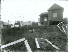
House with a broken wire fence
https://search.heritageburnaby.ca/link/museumdescription3079
- Repository
- Burnaby Village Museum
- Date
- [between 1900 and 1910
- Collection/Fonds
- Burnaby Village Museum Photograph collection
- Description Level
- Item
- Physical Description
- 1 photograph : b&w glass negative
- Scope and Content
- Photograph of an unidentified house with a broken wire fence in its front lawn. There are a couple of houses seen nearby the house and power poles running along a road behind the houses.
- Repository
- Burnaby Village Museum
- Collection/Fonds
- Burnaby Village Museum Photograph collection
- Description Level
- Item
- Physical Description
- 1 photograph : b&w glass negative
- Material Details
- inscribed in the negative, printed on the photograph, c. "no.2"
- Scope and Content
- Photograph of an unidentified house with a broken wire fence in its front lawn. There are a couple of houses seen nearby the house and power poles running along a road behind the houses.
- Accession Code
- HV973.110.10
- Access Restriction
- No restrictions
- Reproduction Restriction
- No known restrictions
- Date
- [between 1900 and 1910
- Media Type
- Photograph
- Scan Resolution
- 300
- Scan Date
- 16/8/2006
- Scale
- 100
- Notes
- Title based on contents of photograph
- 1 b&w contact print accompanying negative
Images

![Island Shore, [between 1908 and 1911] thumbnail](/media/hpo/_Data/_BVM_Images/1972/1972_0050_0015_001.jpg?width=280)
Island Shore
https://search.heritageburnaby.ca/link/museumdescription1076
- Repository
- Burnaby Village Museum
- Date
- [between 1908 and 1911]
- Collection/Fonds
- Burnaby Village Museum Photograph collection
- Description Level
- Item
- Physical Description
- 1 photograph : b&w ; 7.4 x 9.8 cm mounted on paper 13.6 x 18.3 cm
- Scope and Content
- Photograph of an unidentified shoreline as seen from the water. Houses and a church with a steeple are visible.
- Repository
- Burnaby Village Museum
- Collection/Fonds
- Burnaby Village Museum Photograph collection
- Description Level
- Item
- Physical Description
- 1 photograph : b&w ; 7.4 x 9.8 cm mounted on paper 13.6 x 18.3 cm
- Scope and Content
- Photograph of an unidentified shoreline as seen from the water. Houses and a church with a steeple are visible.
- Accession Code
- HV972.50.15
- Access Restriction
- No restrictions
- Reproduction Restriction
- No known restrictions
- Date
- [between 1908 and 1911]
- Media Type
- Photograph
- Scan Resolution
- 600
- Scan Date
- 2023-04-04
- Photographer
- Dean, H.M.
- Notes
- Title based on contents of photograph
Images
![Island Shore, [between 1908 and 1911] thumbnail](/media/hpo/_Data/_BVM_Images/1972/1972_0050_0015_001.jpg)
![Laundry and firewood, [between 1912 and 1925] thumbnail](/media/hpo/_Data/_BVM_Images/1984/1984_0051_0031_001.jpg?width=280)
Laundry and firewood
https://search.heritageburnaby.ca/link/museumdescription259
- Repository
- Burnaby Village Museum
- Date
- [between 1912 and 1925]
- Collection/Fonds
- Burnaby Village Museum Photograph collection
- Description Level
- Item
- Physical Description
- 1 photograph : sepia ; 7.62 x 10.16 cm
- Scope and Content
- Photograph of two women and a man standing at the back of a house. The women are standing by a large metal basin filled with laundry. One of the women is resting the basin on top of a barrel. The man is standing by and holding a large saw, the kind used in logging, that is half dug into a log on …
- Repository
- Burnaby Village Museum
- Collection/Fonds
- Burnaby Village Museum Photograph collection
- Description Level
- Item
- Physical Description
- 1 photograph : sepia ; 7.62 x 10.16 cm
- Scope and Content
- Photograph of two women and a man standing at the back of a house. The women are standing by a large metal basin filled with laundry. One of the women is resting the basin on top of a barrel. The man is standing by and holding a large saw, the kind used in logging, that is half dug into a log on a holder. The house may be the same house as the one depicted in photographs HV984.51.17, .19 and .29. According to the accession register, the location of the house is at Buena Vista, Burnaby, between 1912 and 1925.
- Subjects
- Buildings - Residential - Houses
- Accession Code
- HV984.51.31
- Access Restriction
- No restrictions
- Reproduction Restriction
- No known restrictions
- Date
- [between 1912 and 1925]
- Media Type
- Photograph
- Historic Neighbourhood
- East Burnaby (Historic Neighbourhood)
- Planning Study Area
- Cariboo-Armstrong Area
- Scan Resolution
- 600
- Scan Date
- 2023-10-10
- Notes
- Title based on contents of photograph
Images
![Laundry and firewood, [between 1912 and 1925] thumbnail](/media/hpo/_Data/_BVM_Images/1984/1984_0051_0031_001.jpg)
![Love family at their farmhouse, [1910] (date of original), copied 1998 thumbnail](/media/hpo/_Data/_BVM_Images/2000/200000450004.jpg?width=280)
Love family at their farmhouse
https://search.heritageburnaby.ca/link/museumdescription1553
- Repository
- Burnaby Village Museum
- Date
- [1910] (date of original), copied 1998
- Collection/Fonds
- Love family fonds
- Description Level
- Item
- Physical Description
- 1 photograph : b&w ; 25 x 16.5 cm print
- Scope and Content
- Photograph of Jesse and Martha Love with two of their daughters in front of their farmhouse. Martha is wearing an apron and Jesse is holding his neck with his left hand. The Love farmhouse was located at 1390 Cumberland Road (after 1960- address was changed to 7651 Cumberland Street). The Love far…
- Repository
- Burnaby Village Museum
- Collection/Fonds
- Love family fonds
- Description Level
- Item
- Physical Description
- 1 photograph : b&w ; 25 x 16.5 cm print
- Scope and Content
- Photograph of Jesse and Martha Love with two of their daughters in front of their farmhouse. Martha is wearing an apron and Jesse is holding his neck with his left hand. The Love farmhouse was located at 1390 Cumberland Road (after 1960- address was changed to 7651 Cumberland Street). The Love farmhouse was relocated to the site of the Burnaby Village Museum in 1988 where it was restored to the 1920s era.
- Subjects
- Buildings - Residential - Houses
- Geographic Access
- Cumberland Street
- Street Address
- 7651 Cumberland Street
- Accession Code
- BV000.45.4
- Access Restriction
- No restrictions
- Date
- [1910] (date of original), copied 1998
- Media Type
- Photograph
- Historic Neighbourhood
- East Burnaby (Historic Neighbourhood)
- Planning Study Area
- Cariboo-Armstrong Area
- Scan Resolution
- 600
- Scan Date
- 09-Jun-09
- Scale
- 100
- Notes
- Title based on contents of photograph
- 1 b&w copy negative accompanying
- Note in pencil on verso of photograph reads: "Jesse and Martha Love and 2 daughters Jesse Love Farmhouse"
Images
![Love family at their farmhouse, [1910] (date of original), copied 1998 thumbnail](/media/hpo/_Data/_BVM_Images/2000/200000450004.jpg)
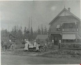
Madill family and house
https://search.heritageburnaby.ca/link/museumdescription832
- Repository
- Burnaby Village Museum
- Date
- 1911 (date of original), copied 1976
- Collection/Fonds
- Burnaby Village Museum Photograph collection
- Description Level
- Item
- Physical Description
- 1 photograph : b&w ; 20 x 25 cm print
- Scope and Content
- Photograph of a large two storey brick house, with a balcony on the second floor, and striped awnings over the windows. There is a wire fence around the property. In front of the house is Madill family in and around a car; six children of various ages and a couple. A horse drawn wagon is on the lef…
- Repository
- Burnaby Village Museum
- Collection/Fonds
- Burnaby Village Museum Photograph collection
- Description Level
- Item
- Physical Description
- 1 photograph : b&w ; 20 x 25 cm print
- Scope and Content
- Photograph of a large two storey brick house, with a balcony on the second floor, and striped awnings over the windows. There is a wire fence around the property. In front of the house is Madill family in and around a car; six children of various ages and a couple. A horse drawn wagon is on the left side of the photograph.
- Subjects
- Buildings - Residential - Houses
- Geographic Access
- Canada Way
- Imperial Street
- Accession Code
- HV976.146.1
- Access Restriction
- No restrictions
- Reproduction Restriction
- No known restrictions
- Date
- 1911 (date of original), copied 1976
- Media Type
- Photograph
- Historic Neighbourhood
- Edmonds (Historic Neighbourhood)
- Scan Resolution
- 600
- Scan Date
- 2023-06-27
- Notes
- Title based on contents of photograph
- An annotation on the back of the photo reads, "Home of Rev. Madill at Canada Way + Imperial 1911."
Images

![Mathers house, [1912] (date of original), copied 1985 thumbnail](/media/hpo/_Data/_BVM_Images/1985/1985_0057_0001_001.jpg?width=280)
Mathers house
https://search.heritageburnaby.ca/link/museumdescription166
- Repository
- Burnaby Village Museum
- Date
- [1912] (date of original), copied 1985
- Collection/Fonds
- Burnaby Village Museum Photograph collection
- Description Level
- Item
- Physical Description
- 1 photograph : b&w ; 20.2 x 25.2 cm print
- Scope and Content
- Photograph of the Mathers house in 1912. There is a family (perhaps the W.J. Mathers family) sitting on the stone-walled patio. Note the electric power pole to the right side of the photograph located close to the house. The house is now part of the Deer Lake Park Complex and is used for various ar…
- Repository
- Burnaby Village Museum
- Collection/Fonds
- Burnaby Village Museum Photograph collection
- Description Level
- Item
- Physical Description
- 1 photograph : b&w ; 20.2 x 25.2 cm print
- Scope and Content
- Photograph of the Mathers house in 1912. There is a family (perhaps the W.J. Mathers family) sitting on the stone-walled patio. Note the electric power pole to the right side of the photograph located close to the house. The house is now part of the Deer Lake Park Complex and is used for various artistic and cultural activities. According to a note prepared by Kathleen and Eileen Mather, the house otherwise known as "Altnadene" was built in 1911-1912 for Mr. and Mrs. W.J. Mathers of New Westminster by architect F.W. Macey who lived on Douglas Road. The house was occupied by the family from late-1912 until mid-1935. The original photographs have been taken by professional photographers.
- Subjects
- Buildings - Residential - Houses
- Geographic Access
- Deer Lake Avenue
- Street Address
- 6490 Deer Lake Avenue
- Accession Code
- BV985.57.1
- Access Restriction
- No restrictions
- Reproduction Restriction
- No known restrictions
- Date
- [1912] (date of original), copied 1985
- Media Type
- Photograph
- Historic Neighbourhood
- Burnaby Lake (Historic Neighbourhood)
- Planning Study Area
- Douglas-Gilpin Area
- Scan Resolution
- 600
- Scan Date
- 2023-12-19
- Notes
- Title based on contents of photograph
Images
![Mathers house, [1912] (date of original), copied 1985 thumbnail](/media/hpo/_Data/_BVM_Images/1985/1985_0057_0001_001.jpg)
![Mathers house, [1913 or 1916] (date of original), copied 1985 thumbnail](/media/hpo/_Data/_BVM_Images/1985/1985_0057_0002_001.jpg?width=280)
Mathers house
https://search.heritageburnaby.ca/link/museumdescription167
- Repository
- Burnaby Village Museum
- Date
- [1913 or 1916] (date of original), copied 1985
- Collection/Fonds
- Burnaby Village Museum Photograph collection
- Description Level
- Item
- Physical Description
- 1 photograph : b&w ; 20.2 x 25.2 cm print
- Scope and Content
- Photograph of the Mathers house with two children on the stone-walled patio and a girl on the lawn. The house is now part of the Deer Lake Park Complex and is used for various artistic and cultural activities. According to a note prepared by Kathleen and Eileen Mathers, the house otherwise known as…
- Repository
- Burnaby Village Museum
- Collection/Fonds
- Burnaby Village Museum Photograph collection
- Description Level
- Item
- Physical Description
- 1 photograph : b&w ; 20.2 x 25.2 cm print
- Scope and Content
- Photograph of the Mathers house with two children on the stone-walled patio and a girl on the lawn. The house is now part of the Deer Lake Park Complex and is used for various artistic and cultural activities. According to a note prepared by Kathleen and Eileen Mathers, the house otherwise known as "Altnadene" was built in 1911-1912 for Mr. and Mrs. W.J. Mathers of New Westminster by architect F.W. Macey who lived on Douglas Road. The house was occupied by the family from late-1912 until mid-1935. he original photographs have been taken by professional photographers. The accession register dates the photograph ca. 1913 while the inscription dates it 1916. An annotation on the back of the photograph reads: "Altnadara [sic] 1916."
- Subjects
- Buildings - Residential - Houses
- Geographic Access
- Deer Lake Avenue
- Street Address
- 6490 Deer Lake Avenue
- Accession Code
- BV985.57.2
- Access Restriction
- No restrictions
- Reproduction Restriction
- No known restrictions
- Date
- [1913 or 1916] (date of original), copied 1985
- Media Type
- Photograph
- Historic Neighbourhood
- Burnaby Lake (Historic Neighbourhood)
- Planning Study Area
- Douglas-Gilpin Area
- Scan Resolution
- 600
- Scan Date
- 2023-12-19
- Notes
- Title based on contents of photograph
Images
![Mathers house, [1913 or 1916] (date of original), copied 1985 thumbnail](/media/hpo/_Data/_BVM_Images/1985/1985_0057_0002_001.jpg)