Narrow Results By

Burnaby Place
https://search.heritageburnaby.ca/link/archivedescription93691
- Repository
- City of Burnaby Archives
- Date
- June 4, 1978
- Collection/Fonds
- Burnaby Public Library Contemporary Visual Archive Project
- Description Level
- Item
- Physical Description
- 1 photograph : b&w ; 12.5 x 17.5 cm
- Scope and Content
- Photograph of a commercial mid-rise building at Patterson Avenue and Kingsway, near Central Park. A Shell gas station is next to the building and a Bank of Nova Scotia occupies the first floor. The photograph is taken from Patterson, facing east on Kingsway. Pedestrians are crossing at the intersec…
- Repository
- City of Burnaby Archives
- Date
- June 4, 1978
- Collection/Fonds
- Burnaby Public Library Contemporary Visual Archive Project
- Physical Description
- 1 photograph : b&w ; 12.5 x 17.5 cm
- Description Level
- Item
- Record No.
- 556-648
- Access Restriction
- No restrictions
- Reproduction Restriction
- Reproduce for fair dealing purposes only
- Accession Number
- 2017-57
- Scope and Content
- Photograph of a commercial mid-rise building at Patterson Avenue and Kingsway, near Central Park. A Shell gas station is next to the building and a Bank of Nova Scotia occupies the first floor. The photograph is taken from Patterson, facing east on Kingsway. Pedestrians are crossing at the intersection.
- Subjects
- Buildings - Commercial
- Buildings - Commercial - Service Stations
- Buildings - Commercial - Banks
- Media Type
- Photograph
- Photographer
- Chapman, Fred
- Notes
- Title taken from project information form
- Accompanied by a project information form and 1 photograph (b&w negative ; 9.5 x 12.5 cm)
- BPL no. 96
- Geographic Access
- Kingsway
- Central Park
- Patterson Avenue
- Historic Neighbourhood
- Central Park (Historic Neighbourhood)
- Planning Study Area
- Maywood Area
Images


Closed Gas Station
https://search.heritageburnaby.ca/link/archivedescription79271
- Repository
- City of Burnaby Archives
- Date
- February 7, 1977
- Collection/Fonds
- Burnaby Public Library Contemporary Visual Archive Project
- Description Level
- Item
- Physical Description
- 1 photograph : b&w ; 11 x 16 cm mounted on cardboard
- Scope and Content
- Photograph shows a closed gas station on Kingsway near McKercher Avenue.
- Repository
- City of Burnaby Archives
- Date
- February 7, 1977
- Collection/Fonds
- Burnaby Public Library Contemporary Visual Archive Project
- Physical Description
- 1 photograph : b&w ; 11 x 16 cm mounted on cardboard
- Description Level
- Item
- Record No.
- 556-233
- Access Restriction
- No restrictions
- Reproduction Restriction
- Reproduce for fair dealing purposes only
- Accession Number
- 2013-13
- Scope and Content
- Photograph shows a closed gas station on Kingsway near McKercher Avenue.
- Media Type
- Photograph
- Notes
- Scope note taken directly from BPL photograph description.
- 1 b&w copy negative : 10 x 12.5 cm accompanying
- Photographers identified by surnames only: Carr and Vardeman
- Geographic Access
- McKercher Avenue
- Kingsway
- Historic Neighbourhood
- Central Park (Historic Neighbourhood)
- Planning Study Area
- Marlborough Area
Images


Crossing Royal Oak & Rumble Street
https://search.heritageburnaby.ca/link/archivedescription93686
- Repository
- City of Burnaby Archives
- Date
- May 19, 1978
- Collection/Fonds
- Burnaby Public Library Contemporary Visual Archive Project
- Description Level
- Item
- Physical Description
- 1 photograph : b&w ; 12.5 x 17.5 cm
- Scope and Content
- Photograph of the intersection of Royal Oak Avenue and Rumble Street. Cars and pedestrians are crossing the intersection, and the signs for businesses TD Bank, Standard Oil/Chevron gas station, Gulf gas station, and Baxter's Market are visible. The photograph is taken from a corner of the intersect…
- Repository
- City of Burnaby Archives
- Date
- May 19, 1978
- Collection/Fonds
- Burnaby Public Library Contemporary Visual Archive Project
- Physical Description
- 1 photograph : b&w ; 12.5 x 17.5 cm
- Description Level
- Item
- Record No.
- 556-643
- Access Restriction
- No restrictions
- Reproduction Restriction
- Reproduce for fair dealing purposes only
- Accession Number
- 2017-57
- Scope and Content
- Photograph of the intersection of Royal Oak Avenue and Rumble Street. Cars and pedestrians are crossing the intersection, and the signs for businesses TD Bank, Standard Oil/Chevron gas station, Gulf gas station, and Baxter's Market are visible. The photograph is taken from a corner of the intersection, facing southeast.
- Subjects
- Geographic Features - Roads
- Advertising Medium - Signs and Signboards
- Buildings - Commercial - Service Stations
- Transportation - Automobiles
- Buildings - Commercial
- Media Type
- Photograph
- Photographer
- van Mannen, Mark
- Notes
- Title taken from project information form
- Accompanied by a project information form and 1 photograph (b&w negative ; 9.5 x 12.5 cm)
- BPL no. 91
- Geographic Access
- Royal Oak Avenue
- Rumble Street
- Historic Neighbourhood
- Alta Vista (Historic Neighbourhood)
- Planning Study Area
- Sussex-Nelson Area
Images


Crossing Royal Oak & Rumble Street
https://search.heritageburnaby.ca/link/archivedescription93687
- Repository
- City of Burnaby Archives
- Date
- May 19, 1978
- Collection/Fonds
- Burnaby Public Library Contemporary Visual Archive Project
- Description Level
- Item
- Physical Description
- 1 photograph : b&w ; 12.5 x 17.5 cm
- Scope and Content
- Photograph of the intersection of Royal Oak Avenue and Rumble Street. Cars and pedestrians are crossing the intersection, and the signs for businesses Grace United Pharmacy, Standard Oil/Chevron gas station, Gulf gas station, and Royal Meats are visible. The photograph is taken from the Gulf gas st…
- Repository
- City of Burnaby Archives
- Date
- May 19, 1978
- Collection/Fonds
- Burnaby Public Library Contemporary Visual Archive Project
- Physical Description
- 1 photograph : b&w ; 12.5 x 17.5 cm
- Description Level
- Item
- Record No.
- 556-644
- Access Restriction
- No restrictions
- Reproduction Restriction
- Reproduce for fair dealing purposes only
- Accession Number
- 2017-57
- Scope and Content
- Photograph of the intersection of Royal Oak Avenue and Rumble Street. Cars and pedestrians are crossing the intersection, and the signs for businesses Grace United Pharmacy, Standard Oil/Chevron gas station, Gulf gas station, and Royal Meats are visible. The photograph is taken from the Gulf gas station parking lot, facing northwest.
- Subjects
- Advertising Medium - Signs and Signboards
- Geographic Features - Roads
- Transportation - Automobiles
- Buildings - Commercial
- Buildings - Commercial - Service Stations
- Media Type
- Photograph
- Photographer
- van Mannen, Mark
- Notes
- Title taken from project information form
- Accompanied by a project information form and 1 photograph (b&w negative ; 9.5 x 12.5 cm)
- BPL no. 92
- Geographic Access
- Royal Oak Avenue
- Rumble Street
- Historic Neighbourhood
- Alta Vista (Historic Neighbourhood)
- Planning Study Area
- Sussex-Nelson Area
Images


Glenwood Service Station
https://search.heritageburnaby.ca/link/archivedescription79264
- Repository
- City of Burnaby Archives
- Date
- November 14, 1976
- Collection/Fonds
- Burnaby Public Library Contemporary Visual Archive Project
- Description Level
- Item
- Physical Description
- 1 photograph : b&w ; 11 x 16 cm mounted on cardboard
- Scope and Content
- Photograph shows a view from Gilley Avenue of the Glenwood Service Station at 5894 Marine Drive.
- Repository
- City of Burnaby Archives
- Date
- November 14, 1976
- Collection/Fonds
- Burnaby Public Library Contemporary Visual Archive Project
- Physical Description
- 1 photograph : b&w ; 11 x 16 cm mounted on cardboard
- Description Level
- Item
- Record No.
- 556-228
- Access Restriction
- No restrictions
- Reproduction Restriction
- Reproduce for fair dealing purposes only
- Accession Number
- 2013-13
- Scope and Content
- Photograph shows a view from Gilley Avenue of the Glenwood Service Station at 5894 Marine Drive.
- Names
- Glenwood Service Station
- Media Type
- Photograph
- Photographer
- Campbell, Peg
- Notes
- Scope note taken directly from BPL photograph description.
- 1 b&w copy negative : 10 x 12.5 cm accompanying
- Geographic Access
- Marine Drive
- Street Address
- 5894 Marine Drive
- Historic Neighbourhood
- Fraser Arm (Historic Neighbourhood)
- Planning Study Area
- Big Bend Area
Images


Highrises on Kingsway
https://search.heritageburnaby.ca/link/archivedescription93692
- Repository
- City of Burnaby Archives
- Date
- June 4, 1978
- Collection/Fonds
- Burnaby Public Library Contemporary Visual Archive Project
- Description Level
- Item
- Physical Description
- 1 photograph : b&w ; 12.5 x 17.5 cm
- Scope and Content
- Photograph of high-rises apartment buildings and the neighbourhood along Kingsway by Central Park. The photograph is taken from a high point, facing east down Kingsway. The Central Park Veterinary Hospital, Central Park Place, a railway crossing, a gas station, and the Central Park Gate are visible…
- Repository
- City of Burnaby Archives
- Date
- June 4, 1978
- Collection/Fonds
- Burnaby Public Library Contemporary Visual Archive Project
- Physical Description
- 1 photograph : b&w ; 12.5 x 17.5 cm
- Description Level
- Item
- Record No.
- 556-649
- Access Restriction
- No restrictions
- Reproduction Restriction
- Reproduce for fair dealing purposes only
- Accession Number
- 2017-57
- Scope and Content
- Photograph of high-rises apartment buildings and the neighbourhood along Kingsway by Central Park. The photograph is taken from a high point, facing east down Kingsway. The Central Park Veterinary Hospital, Central Park Place, a railway crossing, a gas station, and the Central Park Gate are visible in the photograph.
- Subjects
- Buildings - Commercial
- Buildings - Residential - Apartments
- Buildings - Commercial - Service Stations
- Geographic Features - Parks
- Monuments
- Media Type
- Photograph
- Photographer
- Chapman, Fred
- Notes
- Title taken from project information form
- Accompanied by a project information form and 1 photograph (b&w negative ; 9.5 x 12.5 cm)
- BPL no. 97
- Geographic Access
- Kingsway
- Central Park
- Historic Neighbourhood
- Central Park (Historic Neighbourhood)
- Planning Study Area
- Maywood Area
Images

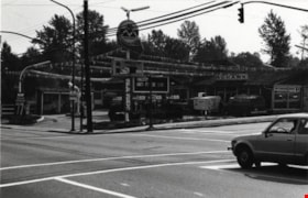
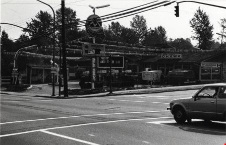
Mohawk Cascade Service Station
https://search.heritageburnaby.ca/link/archivedescription79263
- Repository
- City of Burnaby Archives
- Date
- September 27, 1976
- Collection/Fonds
- Burnaby Public Library Contemporary Visual Archive Project
- Description Level
- Item
- Physical Description
- 1 photograph : b&w ; 11 x 16 cm mounted on cardboard
- Scope and Content
- Photograph shows Mohawk Cascade Service Station at the corner of Canada Way and Smith Avenue.
- Repository
- City of Burnaby Archives
- Date
- September 27, 1976
- Collection/Fonds
- Burnaby Public Library Contemporary Visual Archive Project
- Physical Description
- 1 photograph : b&w ; 11 x 16 cm mounted on cardboard
- Description Level
- Item
- Record No.
- 556-227
- Access Restriction
- No restrictions
- Reproduction Restriction
- Reproduce for fair dealing purposes only
- Accession Number
- 2013-13
- Scope and Content
- Photograph shows Mohawk Cascade Service Station at the corner of Canada Way and Smith Avenue.
- Media Type
- Photograph
- Photographer
- Norton, Paul
- Notes
- Scope note taken directly from BPL photograph description.
- 1 b&w copy negative : 10 x 12.5 cm accompanying
- Geographic Access
- Canada Way
- Smith Avenue
- Historic Neighbourhood
- Broadview (Historic Neighbourhood)
- Planning Study Area
- Cascade-Schou Area
Images
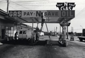
Pay-N-Save Gas Station
https://search.heritageburnaby.ca/link/archivedescription79265
- Repository
- City of Burnaby Archives
- Date
- September 10, 1976
- Collection/Fonds
- Burnaby Public Library Contemporary Visual Archive Project
- Description Level
- Item
- Physical Description
- 1 photograph : b&w ; 11 x 16 cm mounted on cardboard
- Scope and Content
- Photograph shows the Pay-N-Save Gas Station at 6105 Kingsway.
- Repository
- City of Burnaby Archives
- Date
- September 10, 1976
- Collection/Fonds
- Burnaby Public Library Contemporary Visual Archive Project
- Physical Description
- 1 photograph : b&w ; 11 x 16 cm mounted on cardboard
- Description Level
- Item
- Record No.
- 556-229
- Access Restriction
- No restrictions
- Reproduction Restriction
- Reproduce for fair dealing purposes only
- Accession Number
- 2013-13
- Scope and Content
- Photograph shows the Pay-N-Save Gas Station at 6105 Kingsway.
- Names
- Pay-N-Save Gas Station
- Media Type
- Photograph
- Photographer
- Norton, Paul
- Notes
- Scope note taken directly from BPL photograph description.
- 1 b&w copy negative : 10 x 12.5 cm accompanying
- Geographic Access
- Kingsway
- Street Address
- 6105 Kingsway
- Planning Study Area
- Windsor Area
Images

Sali-King Service Station
https://search.heritageburnaby.ca/link/archivedescription79267
- Repository
- City of Burnaby Archives
- Date
- September 22, 1976
- Collection/Fonds
- Burnaby Public Library Contemporary Visual Archive Project
- Description Level
- Item
- Physical Description
- 1 photograph : b&w ; 11 x 16 cm mounted on cardboard
- Scope and Content
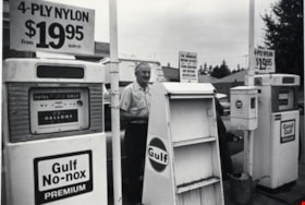
- Photograph shows an attendent at gas pump at Sali-King Service Station on Kingsway near Salisbury Avenue.
- Repository
- City of Burnaby Archives
- Date
- September 22, 1976
- Collection/Fonds
- Burnaby Public Library Contemporary Visual Archive Project
- Physical Description
- 1 photograph : b&w ; 11 x 16 cm mounted on cardboard
- Description Level
- Item
- Record No.
- 556-230
- Access Restriction
- No restrictions
- Reproduction Restriction
- Reproduce for fair dealing purposes only
- Accession Number
- 2013-13
- Scope and Content
- Photograph shows an attendent at gas pump at Sali-King Service Station on Kingsway near Salisbury Avenue.
- Media Type
- Photograph
- Photographer
- Ross, Martha
- Notes
- Scope note taken directly from BPL photograph description.
- 1 b&w copy negative : 10 x 12.5 cm accompanying
- Geographic Access
- Kingsway
- Salisbury Avenue
- Historic Neighbourhood
- Edmonds (Historic Neighbourhood)
- Planning Study Area
- Stride Avenue Area
Images

Shell Self Service
https://search.heritageburnaby.ca/link/archivedescription79270
- Repository
- City of Burnaby Archives
- Date
- September, 1976
- Collection/Fonds
- Burnaby Public Library Contemporary Visual Archive Project
- Description Level
- Item
- Physical Description
- 1 photograph : b&w ; 11 x 16 cm mounted on cardboard
- Scope and Content
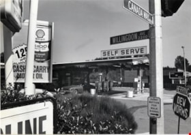
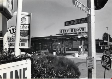
- Photograph shows Freeway Shell Self Service gas station on Canada Way at the corner of Willingdon Avenue.
- Repository
- City of Burnaby Archives
- Date
- September, 1976
- Collection/Fonds
- Burnaby Public Library Contemporary Visual Archive Project
- Physical Description
- 1 photograph : b&w ; 11 x 16 cm mounted on cardboard
- Description Level
- Item
- Record No.
- 556-232
- Access Restriction
- No restrictions
- Reproduction Restriction
- Reproduce for fair dealing purposes only
- Accession Number
- 2013-13
- Scope and Content
- Photograph shows Freeway Shell Self Service gas station on Canada Way at the corner of Willingdon Avenue.
- Names
- Shell Oil Company
- Media Type
- Photograph
- Photographer
- Cook, Alan
- Notes
- Scope note taken directly from BPL photograph description.
- 1 b&w copy negative : 10 x 12.5 cm accompanying
- Geographic Access
- Canada Way
- Willingdon Avenue
- Planning Study Area
- Douglas-Gilpin Area
Images
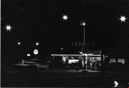
Texaco Gas Station
https://search.heritageburnaby.ca/link/archivedescription79269
- Repository
- City of Burnaby Archives
- Date
- September 24, 1976
- Collection/Fonds
- Burnaby Public Library Contemporary Visual Archive Project
- Description Level
- Item
- Physical Description
- 1 photograph : b&w ; 11 x 16 cm mounted on cardboard
- Scope and Content
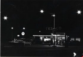
- Photograph shows Texaco Gas Station located on the southwest corner of Kingsway and Merritt Avenue. The station was slated for removal in October 1976.
- Repository
- City of Burnaby Archives
- Date
- September 24, 1976
- Collection/Fonds
- Burnaby Public Library Contemporary Visual Archive Project
- Physical Description
- 1 photograph : b&w ; 11 x 16 cm mounted on cardboard
- Description Level
- Item
- Record No.
- 556-231
- Access Restriction
- No restrictions
- Reproduction Restriction
- Reproduce for fair dealing purposes only
- Accession Number
- 2013-13
- Scope and Content
- Photograph shows Texaco Gas Station located on the southwest corner of Kingsway and Merritt Avenue. The station was slated for removal in October 1976.
- Media Type
- Photograph
- Photographer
- Norton, Paul
- Notes
- Scope note taken directly from BPL photograph description.
- 1 b&w copy negative : 10 x 12.5 cm accompanying
- Geographic Access
- Kingsway
- Merritt Avenue
- Historic Neighbourhood
- Edmonds (Historic Neighbourhood)
- Planning Study Area
- Windsor Area
Images