Narrow Results By
Subject
- Agriculture - Crops 2
- Agriculture - Farms 5
- Animals - Cows 1
- Animals - Dogs 2
- Animals - Horses 1
- Buildings - Agricultural - Barns 2
- Buildings - Industrial - Powerhouses 1
- Buildings - Religious - Churches 2
- Buildings - Residential - Houses 6
- Buildings - Schools 7
- Clothing - Costumes 1
- Clothing - Military Uniforms 1

Broadview Neighbourhood
https://search.heritageburnaby.ca/link/landmark687
- Repository
- Burnaby Heritage Planning
- Associated Dates
- 1925-1954
- Heritage Value
- Development in the Broadview area slowed during World War Two, but after the war, the area became home to a number of industrial sites. The first major plant to be built here was the Dominion Bridge Company which opened in 1930.
- Historic Neighbourhood
- Broadview (Historic Neighbourhood)
- Planning Study Area
- Cascade-Schou Area
Images


Broadview Neighbourhood
https://search.heritageburnaby.ca/link/landmark750
- Repository
- Burnaby Heritage Planning
- Associated Dates
- 1905-1924
- Heritage Value
- Between 1905 and 1924, the Broadview neighbourhood in Burnaby was settled by almost 100 families who saw the advantage of living in an area that was served by two railway lines - the B.C. Electric Railway and the Great Northern Railway. Touted as being only a 20 minute car ride to the city centre, this neighbourhood expanded during the early 1920s with the promise of a new direct access road to the city being built by the Great Northern Railway company and new blocks being opened up on two government reserves adjoining it.
- Historic Neighbourhood
- Broadview (Historic Neighbourhood)
- Planning Study Area
- Cascade-Schou Area
Images


Hugh & Mary McCallum Residence
https://search.heritageburnaby.ca/link/landmark595
- Repository
- Burnaby Heritage Planning
- Description
- Residential building.
- Associated Dates
- c.1912
- Street View URL
- Google Maps Street View
- Repository
- Burnaby Heritage Planning
- Geographic Access
- Regent Street
- Associated Dates
- c.1912
- Description
- Residential building.
- Heritage Value
- Typical of the Arts and Crafts style, the house has its original front gabled roof, triangular eave brackets, full open front verandah and pointed bargeboards. The house has received some alterations, including the addition of asbestos shingles over the original siding. It is one of the few surviving early homes of the Broadview subdivision which was established in 1911. This was the long-term home of Hugh McCallum Senior (1873-1960), a steam engineer from Scotland, and his wife Mary (née Baxter, 1875-1958). Hugh continued to live in the house after Mary’s death.
- Locality
- Broadview
- Historic Neighbourhood
- Broadview (Historic Neighbourhood)
- Planning Study Area
- West Central Valley Area
- Area
- 623.09
- Contributing Resource
- Building
- Ownership
- Private
- Street Address
- 3838 Regent Street
- Street View URL
- Google Maps Street View
Images


Schou Street School
https://search.heritageburnaby.ca/link/landmark637
- Repository
- Burnaby Heritage Planning
- Description
- School building.
- Associated Dates
- 1914
- Street View URL
- Google Maps Street View
- Repository
- Burnaby Heritage Planning
- Geographic Access
- Norfolk Street
- Associated Dates
- 1914
- Description
- School building.
- Heritage Value
- This school was built to replace tents and temporary buildings that had previously been used for the local children of the Broadview neighbourhood. The site was donated to the School Board in 1911 by the real estate firm of Leibly & Blumer in anticipation of increased settlement in the district. The school was named after the street, which had been named after Nicolai Schou, Burnaby’s second Reeve. Originally designed in the Arts and Crafts style, the character of the school was altered in 1964 when its original siding was covered in stucco and the windows were replaced, but has retained its original form and massing, including its front gabled entrance with recessed doorway and twinned square columns. Of special note is the name of the school above the front entry.This school was designed by Joseph H. Bowman (1864-1943), a specialist in school buildings, who was retained as the school board architect for South Vancouver and Burnaby. One of his first designs for Burnaby was a utilitarian two-storey school that could be built with two classrooms and later expanded to eight rooms as the district’s school population grew; five schools from this design were built in 1908, and then four others in modified versions between 1910-16, including this school.
- Locality
- Broadview
- Historic Neighbourhood
- Broadview (Historic Neighbourhood)
- Planning Study Area
- Cascade-Schou Area
- Architect
- Joseph H. Bowman
- Area
- 7660.46
- Contributing Resource
- Building
- Street Address
- 4054 Norfolk Street
- Street View URL
- Google Maps Street View
Images


Altar at St. Andrew's Anglican Church
https://search.heritageburnaby.ca/link/archivedescription38248
- Repository
- City of Burnaby Archives
- Date
- 1924
- Collection/Fonds
- Burnaby Historical Society fonds
- Description Level
- Item
- Physical Description
- 1 photograph : b&w ; 9 x 12.5 cm
- Scope and Content
- Photograph of the altar at St. Andrew's Anglican Church, prepared for Easter Sunday.
- Repository
- City of Burnaby Archives
- Date
- 1924
- Collection/Fonds
- Burnaby Historical Society fonds
- Subseries
- Margaret McCallum subseries
- Physical Description
- 1 photograph : b&w ; 9 x 12.5 cm
- Description Level
- Item
- Record No.
- 375-009
- Access Restriction
- No restrictions
- Reproduction Restriction
- No known restrictions
- Accession Number
- BHS1986-42
- Scope and Content
- Photograph of the altar at St. Andrew's Anglican Church, prepared for Easter Sunday.
- Media Type
- Photograph
- Notes
- Title based on contents of photograph.
- Geographic Access
- Gilmore Avenue
- Norfolk Street
- Historic Neighbourhood
- Broadview (Historic Neighbourhood)
- Planning Study Area
- Cascade-Schou Area
Images


Bob and Olive Urquhart beside Boundary Road
https://search.heritageburnaby.ca/link/archivedescription36759
- Repository
- City of Burnaby Archives
- Date
- March 19, 1913 (date of original), copied 1992
- Collection/Fonds
- Burnaby Historical Society fonds
- Description Level
- Item
- Physical Description
- 1 photograph : b&w ; 10 x 8 cm print
- Scope and Content
- Photograph of Bob and Olive Urquhart soon after their marriage, (they were married March 15). Note the new wood planking on Boundary Road and the train track crossing sign past the house in the distance for the Burnaby Lake Interurban tram line. This photograph was taken looking north on Boundary…
- Repository
- City of Burnaby Archives
- Date
- March 19, 1913 (date of original), copied 1992
- Collection/Fonds
- Burnaby Historical Society fonds
- Subseries
- Burnaby Centennial Anthology subseries
- Physical Description
- 1 photograph : b&w ; 10 x 8 cm print
- Description Level
- Item
- Record No.
- 315-114
- Access Restriction
- No restrictions
- Reproduction Restriction
- No known restrictions
- Accession Number
- BHS1994-04
- Scope and Content
- Photograph of Bob and Olive Urquhart soon after their marriage, (they were married March 15). Note the new wood planking on Boundary Road and the train track crossing sign past the house in the distance for the Burnaby Lake Interurban tram line. This photograph was taken looking north on Boundary Road just south of the railway tracks.
- Subjects
- Geographic Features - Roads
- Media Type
- Photograph
- Notes
- Title based on contents of photograph
- Geographic Access
- Boundary Road
- Myrtle Street
- Historic Neighbourhood
- Broadview (Historic Neighbourhood)
- Planning Study Area
- West Central Valley Area
Images

![Broadview District, [1916] (date of original), copied 1992 thumbnail](/media/hpo/_Data/_Archives_Images/_Unrestricted/315/315-117.jpg?width=280)
Broadview District
https://search.heritageburnaby.ca/link/archivedescription36762
- Repository
- City of Burnaby Archives
- Date
- [1916] (date of original), copied 1992
- Collection/Fonds
- Burnaby Historical Society fonds
- Description Level
- Item
- Physical Description
- 1 photograph : b&w ; 7.8 x 12.5 cm print
- Scope and Content
- Photograph of 3300 block of Clydesdale Street (old street numbering) in the Broadview District neighbourhood, looking east toward Gilmore Avenue. Snake Hill (Burnaby Mountain) can be seen in the background. The homes belong to the Singers, the Urquharts, the Esplins, the Strangs, and the Boggusts.…
- Repository
- City of Burnaby Archives
- Date
- [1916] (date of original), copied 1992
- Collection/Fonds
- Burnaby Historical Society fonds
- Subseries
- Burnaby Centennial Anthology subseries
- Physical Description
- 1 photograph : b&w ; 7.8 x 12.5 cm print
- Description Level
- Item
- Record No.
- 315-117
- Access Restriction
- No restrictions
- Reproduction Restriction
- No known restrictions
- Accession Number
- BHS1994-04
- Scope and Content
- Photograph of 3300 block of Clydesdale Street (old street numbering) in the Broadview District neighbourhood, looking east toward Gilmore Avenue. Snake Hill (Burnaby Mountain) can be seen in the background. The homes belong to the Singers, the Urquharts, the Esplins, the Strangs, and the Boggusts. The people are Ken Muir, Eva Swift and Bob Laird (married after the war), and Olivia and Olive Urquhart (daughter and mother).
- Subjects
- Buildings - Residential - Houses
- Occupations - Military Personnel
- Clothing - Military Uniforms
- Media Type
- Photograph
- Notes
- Title based on contents of photograph
- Geographic Access
- Grandview Highway
- Historic Neighbourhood
- Broadview (Historic Neighbourhood)
- Planning Study Area
- Cascade-Schou Area
Images
![Broadview District, [1916] (date of original), copied 1992 thumbnail](/media/hpo/_Data/_Archives_Images/_Unrestricted/315/315-117.jpg)
![Broadview district covered in snow, [192-?] (date of original), copied 1992 thumbnail](/media/hpo/_Data/_Archives_Images/_Unrestricted/315/315-490.jpg?width=280)
Broadview district covered in snow
https://search.heritageburnaby.ca/link/archivedescription37027
- Repository
- City of Burnaby Archives
- Date
- [192-?] (date of original), copied 1992
- Collection/Fonds
- Burnaby Historical Society fonds
- Description Level
- Item
- Physical Description
- 1 photograph : b&w ; 10.1 x 14.9 cm print
- Scope and Content
- Photograph the Broadview district covered in snow. Annotation under photograph reads, "Backyard of Roma's [Richards] House / House in background is Alex Smith's"
- Repository
- City of Burnaby Archives
- Date
- [192-?] (date of original), copied 1992
- Collection/Fonds
- Burnaby Historical Society fonds
- Subseries
- Burnaby Centennial Anthology subseries
- Physical Description
- 1 photograph : b&w ; 10.1 x 14.9 cm print
- Description Level
- Item
- Record No.
- 315-490
- Access Restriction
- No restrictions
- Reproduction Restriction
- No known restrictions
- Accession Number
- BHS1994-04
- Scope and Content
- Photograph the Broadview district covered in snow. Annotation under photograph reads, "Backyard of Roma's [Richards] House / House in background is Alex Smith's"
- Subjects
- Natural Phenomena - Snow
- Media Type
- Photograph
- Notes
- Title based on contents of photograph
- Historic Neighbourhood
- Broadview (Historic Neighbourhood)
Images
![Broadview district covered in snow, [192-?] (date of original), copied 1992 thumbnail](/media/hpo/_Data/_Archives_Images/_Unrestricted/315/315-490.jpg)

Broadview School
https://search.heritageburnaby.ca/link/archivedescription38237
- Repository
- City of Burnaby Archives
- Date
- 1912
- Collection/Fonds
- Burnaby Historical Society fonds
- Description Level
- Item
- Physical Description
- 1 photograph : sepia ; 16.5 x 21.2 cm on 24.5 x 29.5 cm backing
- Scope and Content
- Photograph of a class of approximately fifty-three children and two teachers outside the newly built Broadview area school. This was the first class photograph at the Broadview School. This shool was later replaced by the Schou Street School and the building was used as a community centre.
- Repository
- City of Burnaby Archives
- Date
- 1912
- Collection/Fonds
- Burnaby Historical Society fonds
- Subseries
- Margaret McCallum subseries
- Physical Description
- 1 photograph : sepia ; 16.5 x 21.2 cm on 24.5 x 29.5 cm backing
- Description Level
- Item
- Record No.
- 375-012
- Access Restriction
- No restrictions
- Reproduction Restriction
- No known restrictions
- Accession Number
- BHS1986-42
- Scope and Content
- Photograph of a class of approximately fifty-three children and two teachers outside the newly built Broadview area school. This was the first class photograph at the Broadview School. This shool was later replaced by the Schou Street School and the building was used as a community centre.
- Names
- Schou Street School
- Media Type
- Photograph
- Notes
- Title based on contents of photograph
- Geographic Access
- Gilmore Avenue
- Grandview Highway
- Canada Way
- Street Address
- 4054 Norfolk Street
- Historic Neighbourhood
- Broadview (Historic Neighbourhood)
- Planning Study Area
- Cascade-Schou Area
Images

![Elsie Nicholson, [1921] thumbnail](/media/hpo/_Data/_Archives_Images/_Unrestricted/371/375-002.jpg?width=280)
Elsie Nicholson
https://search.heritageburnaby.ca/link/archivedescription38241
- Repository
- City of Burnaby Archives
- Date
- [1921]
- Collection/Fonds
- Burnaby Historical Society fonds
- Description Level
- Item
- Physical Description
- 1 photograph : b&w ; 8 x 12.2 cm
- Scope and Content
- Photograph of Elsie Nicholson standing next to the horse named "Holly" at the Nicholson farm in the area of Boundary Road and the C.N.R. rail line. The barns and farm outbuildings can be seen in the background.
- Repository
- City of Burnaby Archives
- Date
- [1921]
- Collection/Fonds
- Burnaby Historical Society fonds
- Subseries
- Margaret McCallum subseries
- Physical Description
- 1 photograph : b&w ; 8 x 12.2 cm
- Description Level
- Item
- Record No.
- 375-002
- Access Restriction
- No restrictions
- Reproduction Restriction
- No known restrictions
- Accession Number
- BHS1986-42
- Scope and Content
- Photograph of Elsie Nicholson standing next to the horse named "Holly" at the Nicholson farm in the area of Boundary Road and the C.N.R. rail line. The barns and farm outbuildings can be seen in the background.
- Subjects
- Agriculture - Farms
- Occupations - Farmers
- Agriculture - Crops
- Transportation - Horses
- Animals - Dogs
- Transportation - Wagons
- Names
- Nicholson, Elsie
- Media Type
- Photograph
- Notes
- Title based on contents of photograph
- Geographic Access
- Boundary Road
- Street Address
- 2550 Boundary Road
- Historic Neighbourhood
- Broadview (Historic Neighbourhood)
- Planning Study Area
- West Central Valley Area
Images
![Elsie Nicholson, [1921] thumbnail](/media/hpo/_Data/_Archives_Images/_Unrestricted/371/375-002.jpg)
![E.W. Nicholson at his farm, [1921] thumbnail](/media/hpo/_Data/_Archives_Images/_Unrestricted/371/375-001.jpg?width=280)
E.W. Nicholson at his farm
https://search.heritageburnaby.ca/link/archivedescription38240
- Repository
- City of Burnaby Archives
- Date
- [1921]
- Collection/Fonds
- Burnaby Historical Society fonds
- Description Level
- Item
- Physical Description
- 1 photograph : b&w ; 8 x 12.5 cm
- Scope and Content
- Photograph of E.W. Nicholson, haying on his farm at Boundary Road and the Canadian National Railway tracks with his horse "Holly."
- Repository
- City of Burnaby Archives
- Date
- [1921]
- Collection/Fonds
- Burnaby Historical Society fonds
- Subseries
- Margaret McCallum subseries
- Physical Description
- 1 photograph : b&w ; 8 x 12.5 cm
- Description Level
- Item
- Record No.
- 375-001
- Access Restriction
- No restrictions
- Reproduction Restriction
- No known restrictions
- Accession Number
- BHS1986-42
- Scope and Content
- Photograph of E.W. Nicholson, haying on his farm at Boundary Road and the Canadian National Railway tracks with his horse "Holly."
- Subjects
- Agriculture - Farms
- Occupations - Farmers
- Agriculture - Crops
- Transportation - Horses
- Animals - Dogs
- Transportation - Wagons
- Names
- Nicholson, E.W.
- Media Type
- Photograph
- Notes
- Title based on contents of photograph
- Geographic Access
- Boundary Road
- Street Address
- 2550 Boundary Road
- Historic Neighbourhood
- Broadview (Historic Neighbourhood)
- Planning Study Area
- West Central Valley Area
Images
![E.W. Nicholson at his farm, [1921] thumbnail](/media/hpo/_Data/_Archives_Images/_Unrestricted/371/375-001.jpg)
![E.W. Nicholson farm, [1921] thumbnail](/media/hpo/_Data/_Archives_Images/_Unrestricted/371/375-005.jpg?width=280)
E.W. Nicholson farm
https://search.heritageburnaby.ca/link/archivedescription38244
- Repository
- City of Burnaby Archives
- Date
- [1921]
- Collection/Fonds
- Burnaby Historical Society fonds
- Description Level
- Item
- Physical Description
- 1 photograph : b&w ; 8.7 x 12.5 cm
- Scope and Content
- Photograph of cattle grazing in the field on the farm belonging to E.W. Nicholson Farm. The Roman Catholic Boys' School can be seen faintly in the background.
- Repository
- City of Burnaby Archives
- Date
- [1921]
- Collection/Fonds
- Burnaby Historical Society fonds
- Subseries
- Margaret McCallum subseries
- Physical Description
- 1 photograph : b&w ; 8.7 x 12.5 cm
- Description Level
- Item
- Record No.
- 375-005
- Access Restriction
- No restrictions
- Reproduction Restriction
- No known restrictions
- Accession Number
- BHS1986-42
- Scope and Content
- Photograph of cattle grazing in the field on the farm belonging to E.W. Nicholson Farm. The Roman Catholic Boys' School can be seen faintly in the background.
- Subjects
- Agriculture - Farms
- Animals - Cows
- Media Type
- Photograph
- Notes
- Title based on contents of photograph
- Geographic Access
- Boundary Road
- Street Address
- 2550 Boundary Road
- Historic Neighbourhood
- Broadview (Historic Neighbourhood)
- Planning Study Area
- West Central Valley Area
Images
![E.W. Nicholson farm, [1921] thumbnail](/media/hpo/_Data/_Archives_Images/_Unrestricted/371/375-005.jpg)

E.W. Nicholson Home in Broadview District
https://search.heritageburnaby.ca/link/archivedescription38254
- Repository
- City of Burnaby Archives
- Date
- 1913
- Collection/Fonds
- Burnaby Historical Society fonds
- Description Level
- Item
- Physical Description
- 1 photograph : b&w ; 9 x 13 cm
- Scope and Content
- Photograph of a man identified as E.W. Nicholson standing in front of his home in the Broadview district.
- Repository
- City of Burnaby Archives
- Date
- 1913
- Collection/Fonds
- Burnaby Historical Society fonds
- Subseries
- Margaret McCallum subseries
- Physical Description
- 1 photograph : b&w ; 9 x 13 cm
- Description Level
- Item
- Record No.
- 375-016
- Access Restriction
- No restrictions
- Reproduction Restriction
- No known restrictions
- Accession Number
- BHS1986-42
- Scope and Content
- Photograph of a man identified as E.W. Nicholson standing in front of his home in the Broadview district.
- Subjects
- Buildings - Residential - Houses
- Names
- Nicholson, E.W.
- Media Type
- Photograph
- Notes
- Title based on caption
- A note on the back of the photograph reads: "First May Day in Broadview District of Burnaby. May 1913. E.W. Nicholson and home."
- Geographic Access
- Boundary Road
- Street Address
- 2550 Boundary Road
- Historic Neighbourhood
- Broadview (Historic Neighbourhood)
- Planning Study Area
- West Central Valley Area
Images


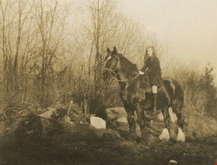
Girl on horseback
https://search.heritageburnaby.ca/link/archivedescription38264
- Repository
- City of Burnaby Archives
- Date
- 1926
- Collection/Fonds
- Burnaby Historical Society fonds
- Description Level
- Item
- Physical Description
- 1 photograph : sepia ; 8.8 x 11.3 cm
- Scope and Content
- Photograph of a young woman, possibly Margaret McCallum, sitting atop a horse in a field. This photograph was most likely taken in the Broadview are of Burnaby, where the McCallum family lived.
- Repository
- City of Burnaby Archives
- Date
- 1926
- Collection/Fonds
- Burnaby Historical Society fonds
- Subseries
- Margaret McCallum subseries
- Physical Description
- 1 photograph : sepia ; 8.8 x 11.3 cm
- Description Level
- Item
- Record No.
- 375-026
- Access Restriction
- No restrictions
- Reproduction Restriction
- No known restrictions
- Accession Number
- BHS1986-42
- Scope and Content
- Photograph of a young woman, possibly Margaret McCallum, sitting atop a horse in a field. This photograph was most likely taken in the Broadview are of Burnaby, where the McCallum family lived.
- Subjects
- Animals - Horses
- Names
- McCallum, Margaret
- Media Type
- Photograph
- Notes
- Title based on contents of photograph
- Historic Neighbourhood
- Broadview (Historic Neighbourhood)
- Planning Study Area
- West Central Valley Area
Images
![Horne Payne Receiving Station, [1920] (date of original), copied 1986 thumbnail](/media/hpo/_Data/_Archives_Images/_Unrestricted/126/158-001.jpg?width=280)
Horne Payne Receiving Station
https://search.heritageburnaby.ca/link/archivedescription34916
- Repository
- City of Burnaby Archives
- Date
- [1920] (date of original), copied 1986
- Collection/Fonds
- Burnaby Historical Society fonds
- Description Level
- Item
- Physical Description
- 1 photograph : b&w ; 8.8 x 12.5 cm print
- Scope and Content
- Photograph of the exterior of the Horne Payne substation, Boundary Road.
- Repository
- City of Burnaby Archives
- Date
- [1920] (date of original), copied 1986
- Collection/Fonds
- Burnaby Historical Society fonds
- Subseries
- Photographs subseries
- Physical Description
- 1 photograph : b&w ; 8.8 x 12.5 cm print
- Description Level
- Item
- Record No.
- 158-001
- Access Restriction
- No restrictions
- Reproduction Restriction
- No known restrictions
- Accession Number
- BHS1986-08
- Scope and Content
- Photograph of the exterior of the Horne Payne substation, Boundary Road.
- Subjects
- Buildings - Industrial - Powerhouses
- Media Type
- Photograph
- Notes
- Caption at lower right of photograph: "Horne-Payne Receiving Station"
- Geographic Access
- 2nd Avenue
- Street Address
- 3700 2nd Avenue
- Historic Neighbourhood
- Broadview (Historic Neighbourhood)
- Planning Study Area
- West Central Valley Area
Images
![Horne Payne Receiving Station, [1920] (date of original), copied 1986 thumbnail](/media/hpo/_Data/_Archives_Images/_Unrestricted/126/158-001.jpg)
![Mary McCormack, [192-?] (date of original), copied 1992 thumbnail](/media/hpo/_Data/_Archives_Images/_Unrestricted/315/315-489.jpg?width=280)
Mary McCormack
https://search.heritageburnaby.ca/link/archivedescription37026
- Repository
- City of Burnaby Archives
- Date
- [192-?] (date of original), copied 1992
- Collection/Fonds
- Burnaby Historical Society fonds
- Description Level
- Item
- Physical Description
- 1 photograph : b&w ; 10.1 x 14.9 cm print
- Scope and Content
- Photograph of Mary McCormack with Aggie, Roma, Betty, John, and Robert on the bridge just west of Schou Street School.
- Repository
- City of Burnaby Archives
- Date
- [192-?] (date of original), copied 1992
- Collection/Fonds
- Burnaby Historical Society fonds
- Subseries
- Burnaby Centennial Anthology subseries
- Physical Description
- 1 photograph : b&w ; 10.1 x 14.9 cm print
- Description Level
- Item
- Record No.
- 315-489
- Access Restriction
- No restrictions
- Reproduction Restriction
- No known restrictions
- Accession Number
- BHS1994-04
- Scope and Content
- Photograph of Mary McCormack with Aggie, Roma, Betty, John, and Robert on the bridge just west of Schou Street School.
- Subjects
- Structures - Bridges
- Names
- McCormack, Mary
- Media Type
- Photograph
- Notes
- Title based on contents of photograph
- Historic Neighbourhood
- Broadview (Historic Neighbourhood)
- Planning Study Area
- West Central Valley Area
Images
![Mary McCormack, [192-?] (date of original), copied 1992 thumbnail](/media/hpo/_Data/_Archives_Images/_Unrestricted/315/315-489.jpg)

Municipality of Burnaby - Volume XVI and Volume XVII
https://search.heritageburnaby.ca/link/museumdescription8684
- Repository
- Burnaby Village Museum
- Date
- May 1927
- Collection/Fonds
- Burnaby Village Museum Map collection
- Description Level
- File
- Physical Description
- 4 plans on 4 sheets : col. lithographic prints ; 63.5 x 53.5 cm folded to 53 x 31.5 cm
- Scope and Content
- File consists of four pages of plans removed from a bound book containing a series of fire insurance plans of the Municipality of Burnaby. Page "D" is titled: "GREATER VANCOUVER B.C. / VOLUME XVI / Surveyed _ May 1927 / MUNICIPALITY OF / BURNABY / PLAN DEPT. FIRE BRANCH _ B.C. INSURANCE UNDERWRITE…
- Repository
- Burnaby Village Museum
- Collection/Fonds
- Burnaby Village Museum Map collection
- Description Level
- File
- Physical Description
- 4 plans on 4 sheets : col. lithographic prints ; 63.5 x 53.5 cm folded to 53 x 31.5 cm
- Material Details
- Scale [1:1200] and [1:6000]
- Scope and Content
- File consists of four pages of plans removed from a bound book containing a series of fire insurance plans of the Municipality of Burnaby. Page "D" is titled: "GREATER VANCOUVER B.C. / VOLUME XVI / Surveyed _ May 1927 / MUNICIPALITY OF / BURNABY / PLAN DEPT. FIRE BRANCH _ B.C. INSURANCE UNDERWRITERS ASSN." / KEY PLAN". Plans covered in this "Key Plan" are numbered 1601 to 1626, 1632 and 1651 covering District Lots: 15; 31; 100 to 102; 114; 141 to 144; 147 and 148; 209 to 214. Plan "E" is part of "GREATER VANCOUVER B.C. / VOLUME XVII / Municipality of Burnaby / May 1927" and covers plans: 1701 to 1705; 1711 to 1715; 1723 to 1727; 1729 to 1733; 1737 to 1742 and District Lots: 68 to 74; 80 to 84; 32 to 35 and 38 to 39. Plan marked "F" is a key plan titled: "GREATER VANCOUVER B.C. / VOLUME XVII / Surveyed _ May 1927 / MUNICIPALITY OF / BURNABY and covers plans: 1706 to 1710; 1716 to 1722; 1734 and 1735; 1743 to 1752 and District Lots: 42 to 44; 59; 75 to 80; 83 to 87; 89 to 93 and 130. Plan "1729" is part of "GREATER VANCOUVER B.C. / VOLUME XVII / Municipality of Burnaby / May 1927" and covers District Lots 34 and 35.
- Responsibility
- British Columbia Underwriters' Association
- Accession Code
- HV972.111.6
- Access Restriction
- No restrictions
- Reproduction Restriction
- May be restricted by third party rights
- Date
- May 1927
- Media Type
- Cartographic Material
- Historic Neighbourhood
- Barnet (Historic Neighbourhood)
- Burquitlam (Historic Neighbourhood)
- Central Park (Historic Neighbourhood)
- Burnaby Lake (Historic Neighbourhood)
- Broadview (Historic Neighbourhood)
- Planning Study Area
- Burnaby Mountain Area
- Lyndhurst Area
- Lake City Area
- Cascade-Schou Area
- Garden Village Area
- Douglas-Gilpin Area
- Oakalla Area
- Scan Resolution
- 400
- Scan Date
- 2021-11-18
- Notes
- Title based on content of plans
- See also BV987.1.70d for revised versions of plans
- Scale is measured 1 inch = 500 feet
Zoomable Images


Municipality of Burnaby - Volume XV, Volume XVI, Volume XVII, Volume XVIII
https://search.heritageburnaby.ca/link/museumdescription8685
- Repository
- Burnaby Village Museum
- Date
- May 1927
- Collection/Fonds
- Burnaby Village Museum Map collection
- Description Level
- File
- Physical Description
- 4 plans on 4 sheets : col. lithographic prints ; 63.5 x 53.5 cm folded to 53 x 31.5 cm
- Scope and Content
- File consists of four pages of plans removed from a bound book containing a series of fire insurance plans of the Municipality of Burnaby. Plan "1531" is part of "GREATER VANCOUVER B.C. / VOLUME XV / Municipality of Burnaby / May 1927" and covers District Lots: 116 and 117. Key Plan "C" is part of …
- Repository
- Burnaby Village Museum
- Collection/Fonds
- Burnaby Village Museum Map collection
- Description Level
- File
- Physical Description
- 4 plans on 4 sheets : col. lithographic prints ; 63.5 x 53.5 cm folded to 53 x 31.5 cm
- Material Details
- Scale [1:600] and [1:1200]
- Scope and Content
- File consists of four pages of plans removed from a bound book containing a series of fire insurance plans of the Municipality of Burnaby. Plan "1531" is part of "GREATER VANCOUVER B.C. / VOLUME XV / Municipality of Burnaby / May 1927" and covers District Lots: 116 and 117. Key Plan "C" is part of "GREATER VANCOUVER B.C. / VOLUME XVI / Municipality of Burnaby / May 1927" and covers plans 1623 to 1651 and District Lots: 1 and 2; 4; 6; 8; 10 to 14; 25; 27; 40; 56 to 58; 88 and 89. Plan "1738" is part of "GREATER VANCOUVER B.C. / VOLUME XVII / Municipality of Burnaby / May 1927" and covers District Lots: 34 and 35. Key plan "G" is part of "GREATER VANCOUVER B.C. / VOLUME XVIII / Municipality of Burnaby / May 1927" and covers plans: 1801 to 1813; 1823; 1824; 1833 to 1838; 1841 to 1853 and District Lots: 32; 93; 94; 97 to 99; 149; 150; 152; 155 to 159; 161 to 164.
- Responsibility
- British Columbia Underwriters' Association
- Accession Code
- HV972.111.7
- Access Restriction
- No restrictions
- Reproduction Restriction
- May be restricted by third party rights
- Date
- May 1927
- Media Type
- Cartographic Material
- Historic Neighbourhood
- Central Park (Historic Neighbourhood)
- Fraser Arm (Historic Neighbourhood)
- Alta Vista (Historic Neighbourhood)
- Broadview (Historic Neighbourhood)
- Vancouver Heights (Historic Neighbourhood)
- Burquitlam (Historic Neighbourhood)
- East Burnaby (Historic Neighbourhood)
- Edmonds (Historic Neighbourhood)
- Lozells (Historic Neighbourhood)
- Planning Study Area
- Clinton-Glenwood Area
- Marlborough Area
- Maywood Area
- Windsor Area
- Big Bend Area
- Garden Village Area
- Willingdon Heights Area
- West Central Valley Area
- Cariboo-Armstrong Area
- Lyndhurst Area
- Cameron Area
- Lake City Area
- Edmonds Area
- Second Street Area
- Sperling-Broadway Area
- Lakeview-Mayfield Area
- Scan Resolution
- 400
- Scan Date
- 2021-11-18
- Notes
- Title based on content of plans
- See also BV987.1.70d for revised versions of plans
- Scale is measured 1 inch = 500 feet
Zoomable Images

Municipality of Burnaby - Volume XV, Volume XVI, Volume XVII, Volume XVIII, May 1927
Zoom into Image
![Nicholson farm, [1921] thumbnail](/media/hpo/_Data/_Archives_Images/_Unrestricted/371/375-003.jpg?width=280)
Nicholson farm
https://search.heritageburnaby.ca/link/archivedescription38242
- Repository
- City of Burnaby Archives
- Date
- [1921]
- Collection/Fonds
- Burnaby Historical Society fonds
- Description Level
- Item
- Physical Description
- 1 photograph : b&w ; 9 x 12.5 cm
- Scope and Content
- Photograph of four men standing alongside a team of horses working in the field at the farm belonging to E.W. Nicholson. The house and barns can be seen in the background.
- Repository
- City of Burnaby Archives
- Date
- [1921]
- Collection/Fonds
- Burnaby Historical Society fonds
- Subseries
- Margaret McCallum subseries
- Physical Description
- 1 photograph : b&w ; 9 x 12.5 cm
- Description Level
- Item
- Record No.
- 375-003
- Access Restriction
- No restrictions
- Reproduction Restriction
- No known restrictions
- Accession Number
- BHS1986-42
- Scope and Content
- Photograph of four men standing alongside a team of horses working in the field at the farm belonging to E.W. Nicholson. The house and barns can be seen in the background.
- Media Type
- Photograph
- Notes
- Title based on contents of photograph
- Geographic Access
- Boundary Road
- Street Address
- 2550 Boundary Road
- Historic Neighbourhood
- Broadview (Historic Neighbourhood)
- Planning Study Area
- West Central Valley Area
Images
![Nicholson farm, [1921] thumbnail](/media/hpo/_Data/_Archives_Images/_Unrestricted/371/375-003.jpg)

Nicholson Farm
https://search.heritageburnaby.ca/link/archivedescription38255
- Repository
- City of Burnaby Archives
- Date
- 1910
- Collection/Fonds
- Burnaby Historical Society fonds
- Description Level
- Item
- Physical Description
- 1 photograph : b&w ; 10.2 x 15.2 cm
- Scope and Content
- Photograph of the home and barns at the farm of E.W. Nicholson and Elsie Nicholson.
- Repository
- City of Burnaby Archives
- Date
- 1910
- Collection/Fonds
- Burnaby Historical Society fonds
- Subseries
- Margaret McCallum subseries
- Physical Description
- 1 photograph : b&w ; 10.2 x 15.2 cm
- Description Level
- Item
- Record No.
- 375-017
- Access Restriction
- No restrictions
- Reproduction Restriction
- No known restrictions
- Accession Number
- BHS1986-42
- Scope and Content
- Photograph of the home and barns at the farm of E.W. Nicholson and Elsie Nicholson.
- Media Type
- Photograph
- Notes
- Title based on contents of photograph
- A note on the back of the photograph reads: "Home of E.W. Nicholson 1900-1951 and Elsie Nicholson 1934-1951. Boundary Road and Great Northern Railway. Property sold to Link-Belt Co. in 1951."
- Geographic Access
- Boundary Road
- Street Address
- 2550 Boundary Road
- Historic Neighbourhood
- Broadview (Historic Neighbourhood)
- Planning Study Area
- West Central Valley Area
Images
