Narrow Results By
Subject
- Accidents - Automobile Accidents 2
- Accidents - Train Accidents 2
- Advertising Medium 14
- Advertising Medium - Signs and Signboards 13
- Agriculture - Fruit and Berries 1
- Animals - Dogs 2
- Building Components 1
- Building Components - Windows 1
- Buildings - Civic - Museums 1
- Buildings - Commercial 2
- Buildings - Commercial - General Stores 1
- Buildings - Commercial - Stores 3
Person / Organization
- Allen, James Charles 1
- Alta Vista Baptist Church 1
- British Columbia Electric Railway 3
- British Columbia Electric Railway Company 277
- British Columbia Hydro and Power Authority 2
- Brownlee, James Harrison 1
- Burnaby Historical Society 2
- Burnaby Village Museum 3
- Canadian National Railway 2
- Carson, Norman Thomas "Tom" 3
- Central Park Provincial Park Board 1
- Ceperley, Grace 1

George S. & Jessie Haddon House
https://search.heritageburnaby.ca/link/landmark508
- Repository
- Burnaby Heritage Planning
- Description
- The George and Jessie Haddon House is a symmetrical two-storey Dutch Colonial-style house with a side-gambrel roof and shed dormers. It is situated in the Burnaby Lake neighborhood in East Burnaby.
- Associated Dates
- 1922
- Formal Recognition
- Heritage Designation, Community Heritage Register
- Street View URL
- Google Maps Street View
- Repository
- Burnaby Heritage Planning
- Geographic Access
- Buckingham Avenue
- Associated Dates
- 1922
- Formal Recognition
- Heritage Designation, Community Heritage Register
- Enactment Type
- Bylaw No. 12064
- Enactment Date
- 19/06/2006
- Description
- The George and Jessie Haddon House is a symmetrical two-storey Dutch Colonial-style house with a side-gambrel roof and shed dormers. It is situated in the Burnaby Lake neighborhood in East Burnaby.
- Heritage Value
- Built in 1923, the George and Jessie Haddon House is a significant example of the romantic period revival styles that were popular during the period between the two World Wars. These traditionally styled homes reflected ongoing pride in past traditions but also recognized the modern ideals of economy and good design. At the time, houses displayed traditional and readily-identifiable historical styles as a hallmark of good taste. The use of the various Colonial Revival styles had gained new popularity during the 1920s, and this design could have originated in a residential pattern book, which were in wide circulation and used to expedite residential projects. This house displays the typical features of the Dutch Colonial style, imported from the eastern United States and relatively rare on the West Coast. The house originally featured an unusual porte-cochere with tapered supports, that indicated the growing importance of automobiles at the time. The house was built for George Samuel Haddon (1886-1971) and his wife Jessie (née Reade) Haddon, whom he married in 1915. George Haddon, who was born in British Columbia, was a prominent Vancouver figure and served as Secretary of the Vancouver General Hospital. Following Jessie's death, George Haddon was remarried to Alice Margaret Currie (1890-1951). The George and Jessie Haddon House is further valued for its connection with the continued development of the Burnaby Lake neighbourhood in the 1920s. The area was highly desirable to wealthy Vancouver and New Westminster residents because of its scenery, and easy access was provided by the British Columbia Electric Railway 'Burnaby Lake' interurban line, which opened in June 1911. The Haddon House illustrates the evolving nature of regional transportation and the growing communities made possible by increasing options for transportation. The house originally stood on a larger lot, and was relocated in 2006 to allow for subdivision and legal protection. The current owners restored the porte-cochere in 2014.
- Defining Elements
- Key elements that define the heritage character of the George and Jessie Haddon House include its: - location within the Burnaby Lake neighbourhood - residential form, scale and massing as expressed by its two-storey height and gambrel roof with shed dormers - rough-cast stucco cladding - Colonial Revival details such as the symmetrical façade and massing, and side-gambrel roof with shed dormers - additional exterior features such as an interior chimney, exposed purlins and window boxes supported on large projecting brackets - wooden front door with glazed insets - interior features including original staircase, and wooden door and window trim
- Historic Neighbourhood
- Burnaby Lake (Historic Neighbourhood)
- Planning Study Area
- Morley-Buckingham Area
- Builder
- William Dodson
- Function
- Primary Historic--Single Dwelling
- Cadastral Identifier
- P.I.D.026-745-127
- Boundaries
- The George and Jessie Haddon House is comprised of a single residential lot located at 5558 Buckingham Avenue, Burnaby.
- Area
- 1080
- Contributing Resource
- Building
- Ownership
- Private
- Documentation
- City of Burnaby Planning and Building Department, Heritage Site Files
- Street Address
- 5558 Buckingham Avenue
- Street View URL
- Google Maps Street View
Images


H.T. Ceperley Estate 'Fairacres' Mansion
https://search.heritageburnaby.ca/link/landmark526
- Repository
- Burnaby Heritage Planning
- Description
- 'Fairacres' is a large, two-and-one-half storey estate house in the British Arts and Crafts style, located in Deer Lake Park, with four associated original outbuildings.
- Associated Dates
- 1911
- Formal Recognition
- Heritage Designation, Community Heritage Register
- Other Names
- Henry Tracy & Grace Ceperley Estate
- Burnaby Art Gallery
- Street View URL
- Google Maps Street View
- Repository
- Burnaby Heritage Planning
- Other Names
- Henry Tracy & Grace Ceperley Estate
- Burnaby Art Gallery
- Geographic Access
- Deer Lake Avenue
- Associated Dates
- 1911
- Formal Recognition
- Heritage Designation, Community Heritage Register
- Enactment Type
- Bylaw No. 9807
- Enactment Date
- 23/11/1992
- Description
- 'Fairacres' is a large, two-and-one-half storey estate house in the British Arts and Crafts style, located in Deer Lake Park, with four associated original outbuildings.
- Heritage Value
- 'Fairacres' is important as a record of the early years of Burnaby, specifically the Deer Lake area, as a place of tranquility and beautiful scenery in which the wealthy and successful in the burgeoning cities of New Westminster and Vancouver chose to retire or to make their family homes. The main house, which anchors in style and setting the outbuildings on the estate, demonstrates the social, cultural, and aesthetic values of local wealthy businessmen and women of the early twentieth century - values such as appreciation of architectural elegance and grand interior spaces, leisure and recreation, formal landscaped gardens and scenic views. Also important is the association with the English-born and trained architect Robert Mackay Fripp (1858-1917), as this was one of his grandest residential commissions. Steeped in the current architectural trends in Great Britain, Fripp designed this sprawling mansion in the Arts and Crafts style, reflected in the architectural detailing and proportions. The style was common at the time and was often used for estate mansions as a symbol of affluence and good, modern taste as well as an affinity for all things British. Quality is displayed inside and out in the finishes and materials, orchestrated by prominent local contractor, James Charles Allen, including imported English materials of specific value such as imported Medmenham tiles in the fireplace surrounds, one of the earliest documented use of these tiles outside the United Kingdom. Detailed features of the interior woodwork were carved by Scottish-born master wood carver George Selkirk Gibson (1867-1942), who was best known for his many commissions for prominent British Columbia architect Samuel Maclure. The outbuildings at 'Fairacres' are an important record of the functioning of a large estate of the time. The Garage and Stables and the Chauffeur’s Cottage accommodated the use of automobiles, horses and carriages, and in concert with the estate's location near the new British Columbia Electric Railway 'Burnaby Lake' interurban line, illustrate the evolving nature of regional transportation and the growing bedroom communities and estates made possible by increasing options for transportation. Other outbuildings accommodated the agricultural activities that helped support the Ceperley estate. The estate was conceived and funded by American-born Grace E. Dixon Ceperley (1863-1917), who had achieved significant wealth through a bequest from her brother-in-law, Vancouver pioneer Arthur Ferguson. Her husband, Henry Tracy Ceperley (1850-1929), also American-born, was a successful and well-respected businessman who made a significant contribution to the development of the City of Vancouver. The construction of 'Fairacres' spawned the transformation of the Deer Lake area from a farming community into a preferred location for elite suburban homes. 'Fairacres' is significant to the City of Burnaby as its first civic heritage conservation project. Acquired in 1966 for conversion to Burnaby’s first art gallery, it was dedicated in 1967 to mark Canada’s Centennial of Confederation.
- Defining Elements
- Key elements that define the heritage character of the ‘Fairacres’ mansion include its: - setting in relation to the gardens, its former market garden, and the vistas to Deer Lake and other grand homes in the area - side gable roof with prominent dormers and cedar shingle cladding - verandah across the eastern (garden) facade, with its view over the landscaped gardens and the distant mountains - porte cochere with its side steps for those arriving by automobile, and central raised step for those alighting from horse-drawn carriages - rich variety of exterior elements that demonstrate the typical Arts and Crafts use of local materials such as cobble stone chimneys and foundations, wide wooden siding and half-timbering - mixture of double-hung and casement wooden-sash windows, many with multi-paned sash - lavish interior spaces, designed for entertaining on a grand scale, including a billiard room with a beamed ceiling and an inglenook fireplace, and generous living and dining rooms arranged off a central hall - quality of the interior materials such as imported Medmenham tiles in fireplace surrounds, window hardware by Hope and Sons, and leaded stained glass - interior wood work including the staircase, and carvings by George Selkirk Gibson - remaining formal Edwardian garden landscape elements, including the cross-axial plan that reflects the relationship of the mansion to its 'outdoor rooms'
- Locality
- Deer Lake Park
- Historic Neighbourhood
- Burnaby Lake (Historic Neighbourhood)
- Planning Study Area
- Douglas-Gilpin Area
- Architect
- Robert Mackay Fripp
- Function
- Primary Current--Museum
- Primary Historic--Estate
- Community
- Burnaby
- Cadastral Identifier
- P.I.D. No. 004-493-311 Legal Description: Block 3 Except: Part subdivided by Plan 26865, District Lot 79, Group 1, New Westminster District, Plan 536
- Boundaries
- ‘Fairacres’ is comprised of a single municipally-owned property located at 6344 Deer Lake Avenue, Burnaby.
- Area
- 17,065.00
- Contributing Resource
- Building
- Landscape Feature
- Ownership
- Public (local)
- Other Collection
- City of Burnaby, Visual Art Collection: Original rendering by R.P.S. Twizell Burnaby Historical Society, Community Archives: Ceperley Photograph Album Burnaby Village Museum, Collection: Carved dining room panels by G.S. Gibson and other hardware items
- Documentation
- Heritage Site Files: PC77000 20. City of Burnaby Planning and Building Department, 4949 Canada Way, Burnaby, B.C., V5G 1M2
- Names
- Ceperley, Grace
- Ceperley, H.T.
- Fripp, Robert Mackay
- Allen, James Charles
- Gibson, George Selkirk
- Street Address
- 6344 Deer Lake Avenue
- Street View URL
- Google Maps Street View
Images


St. John the Divine Anglican Church
https://search.heritageburnaby.ca/link/landmark514
- Repository
- Burnaby Heritage Planning
- Description
- St. John the Divine Anglican Church is a landmark wood-frame Gothic Revival church, with Gothic windows and spire. It is located on Kingsway, one of Burnaby’s main commercial thoroughfares, near the SkyTrain transit line and across the street from Central Park.
- Associated Dates
- 1905
- Formal Recognition
- Community Heritage Register
- Street View URL
- Google Maps Street View
- Repository
- Burnaby Heritage Planning
- Geographic Access
- Kingsway
- Associated Dates
- 1905
- Formal Recognition
- Community Heritage Register
- Enactment Type
- Council Resolution
- Enactment Date
- 09/06/2003
- Description
- St. John the Divine Anglican Church is a landmark wood-frame Gothic Revival church, with Gothic windows and spire. It is located on Kingsway, one of Burnaby’s main commercial thoroughfares, near the SkyTrain transit line and across the street from Central Park.
- Heritage Value
- St. John the Divine Anglican Church is valued as a symbol of the traditions of early Burnaby pioneers and as the oldest surviving church building in the city. Established in 1899, St. John was the first church in the community and was located at a prominent intersection of the old Vancouver-Westminster Road (now Kingsway) and the British Columbia Electric Railway’s interurban station at Central Park. This prominent intersection of the road and rail developed as the town centre of the Central Park district. The first St. John church was destroyed by fire, and was rebuilt at the same location in 1904-05. This church is additionally significant for its association with prominent local architect Joseph Henry Bowman (1864-1943) who emigrated from England in 1888. Bowman was a member of the parish, and designed both the first church and its subsequent replacement. Bowman’s prolific career embraced many stylistic changes and technological advances, and this church is a surviving example of one of his rare religious commissions. The design of the new church's nave and vestry was based on the Gothic Revival style of Christ Church Anglican in Surrey, B.C., which had been the former church of St. John’s incumbent Rev. William Bell. Evolving over time as the congregation grew, the church received a number of early additions, and in 1953 was substantially renovated and enlarged through a new design by Vancouver architect Ross Lort. The original church nave was separated from the tower and turned to allow for a large addition. The congregation relocated to a new church in 1998, and at that time removed the church's memorial windows, leaving behind a number of the original art glass windows installed in the 1920s. The church building was renovated in 2004-05, and surviving original elements were retained and restored, including of the original church tower and interior chancel ceiling. A valued feature of the building is the original cast iron church bell that remains in the tower. It was purchased by the children of the congregation in 1912, and in 1924 was rededicated on Armistice Day as a memorial to Burnaby resident Lt. James Donald McRae Reid, who died in the First World War.
- Defining Elements
- Key elements that define the heritage character of St. John the Divine Anglican Church include its: - location on the north side of Kingsway, opposite Central Park - ecclesiastical form, scale and massing as expressed by the offset tower and tall, gabled roof - tower with its original horizontal wooden drop siding, bellcast square roof with octagonal drum above and bellcast octagonal spire - cedar shingle roof cladding - metal cross at peak of spire - Gothic Revival details such as: Gothic lancet windows with leaded stained glass panels; Gothic entrance door at the base of the tower; pointed-arch louvers in the tower; and exterior gable end scissor-trusses - interior features such as wooden scissor-trusses with diagonal fir tongue and groove panelling on the ceiling above, fir tongue-and-groove panelling on the wall of the nave, and original cedar and fir pews and altar rails - cast iron bell in tower
- Historic Neighbourhood
- Central Park (Historic Neighbourhood)
- Planning Study Area
- Garden Village Area
- Architect
- Joesph Henry Bowman
- Function
- Primary Historic--Place of Worship
- Primary Current--Place of Worship
- Community
- Burnaby
- Cadastral Identifier
- 003-398-871
- Boundaries
- St. John the Divine Anglican Church is comprised of a single institutional lot located at 3891 Kingway, Burnaby.
- Area
- 3486.66
- Contributing Resource
- Building
- Ownership
- Private
- Street Address
- 3891 Kingsway
- Street View URL
- Google Maps Street View
Images


T.O. Townley Estate 'Deerholme'
https://search.heritageburnaby.ca/link/landmark545
- Repository
- Burnaby Heritage Planning
- Description
- The T.O. Townley Estate, 'Deerholme,' is located on a lake front property on the north shore of Deer Lake Park. The main house is a two-and-one-half storey symmetrical-massed wood-frame Colonial Revival structure, with flanking one-storey wings, a side gable roof and a central front entry.
- Associated Dates
- 1913
- Formal Recognition
- Heritage Designation, Community Heritage Register
- Other Names
- Thomas & Frances Townley Estate, Loftus House
- Street View URL
- Google Maps Street View
- Repository
- Burnaby Heritage Planning
- Other Names
- Thomas & Frances Townley Estate, Loftus House
- Geographic Access
- Price Street
- Associated Dates
- 1913
- Formal Recognition
- Heritage Designation, Community Heritage Register
- Enactment Type
- Bylaw No. 9807
- Enactment Date
- 23/11/1992
- Description
- The T.O. Townley Estate, 'Deerholme,' is located on a lake front property on the north shore of Deer Lake Park. The main house is a two-and-one-half storey symmetrical-massed wood-frame Colonial Revival structure, with flanking one-storey wings, a side gable roof and a central front entry.
- Heritage Value
- 'Deerholme' was built as the retirement estate of Lieutenant-Colonel Thomas Owen Townley (1862-1935) and his wife, Frances M. Townley. Townley was a pioneer resident of the Lower Mainland of British Columbia: he served as a lawyer, Registrar of Land Titles for New Westminster District and Mayor of Vancouver for one term in 1901. Built in 1913, this is one of the most significant of the Deer Lake estate houses and was the last of grand Edwardian era mansions built on the lots surrounding the lake. The area had been opened up for development two years earlier by the construction of the British Columbia Electric Railway Interurban Line. The estate speaks of a gracious way of life achieved by society's elite during the Edwardian era, supported by the use of domestic servants. Grand in scale, architecturally sophisticated and set in a bucolic landscape, this residence demonstrates the social status of the owner in the privileged classes of the rapidly developing social structure of Burnaby. The house is also significant as one of the earliest designs by the son of Thomas and Frances Townley, architect Fred Laughton Townley (1887-1966), who had graduated in architecture in 1911 from the University of Pennsylvania. In this house for his parents, he demonstrated his deft understanding of the American Period Revival styles learned during his schooling in the United States. The prevailing local taste for British-derived architecture dictated that this was a style he was rarely able to use until the Colonial Revival styles became more popular in the 1920s. F.L. Townley was a founding partner in Townley and Matheson, which achieved significant success as one of the most accomplished local architectural firms, culminating in their best-known commission, Vancouver City Hall, 1935-36.
- Defining Elements
- Key elements the define the heritage character of ‘Deerholme’ include its: - integration with its south-sloping lakefront site, which contains many original landscape features (extant rockeries, formal drive, tennis lawn, open fields, and specimen shrubs and trees) - two-and-one-half storey form with flanking one-storey wings - side gable roof with symmetrical shed dormers, three at the front and three at the rear - complex fenestration, including multi-paned wooden-sash double-hung windows, 6-over-1 on the ground floor and 6-over-9 on the second floor, and multi-paned wooden-sash casements in the dormers - pair of prominent exterior brick chimneys on each side elevation, clad with rough-cast stucco up to the roof level, and each with four chimney-pots - rough-cast stucco cladding - design elements typical of the Colonial Revival style, such as composed classical formality, side gable roof and balanced symmetrical massing - exterior architectural elements, such as classical columns, window shutters, fanlight feature window, multi-paned quarter-round windows flanking the chimneys, and projecting square brackets in the gables - superior level of design and craftsmanship throughout, including refined interior woodwork such as fireplaces, interior columned screen between hallway and living room and a staircase with Colonial Revival details - significant mature trees (such as Red Oaks, Silver Maples, and Copper Beech). - original guest house and stables, which survive on an adjacent property at 6176 Price Street
- Historic Neighbourhood
- Burnaby Lake (Historic Neighbourhood)
- Planning Study Area
- Douglas-Gilpin Area
- Architect
- Fred Laughton Townley
- Function
- Primary Current--Estate
- Primary Historic--Estate
- Community
- Burnaby
- Cadastral Identifier
- P.I.D. No. 002-652-111 Legal Description: Parcel 'C' (Explanatory Plan 12891) , Blocks 4 and 5, District Lot 79 Group 1, New Westminster District, Plan 536
- Boundaries
- ‘Deerholme’ is comprised of a single municipally-owned property located at 6110 Price Street, Burnaby.
- Area
- 14,099.52
- Contributing Resource
- Building
- Landscape Feature
- Ownership
- Public (local)
- Other Collection
- City of Vancouver Archives: T.O. Townley Residence, Original Plans, Add. MSS. 1399, Temporary No. 61, Location 920-D
- Documentation
- Heritage Site Files: PC77000 20. City of Burnaby Planning and Building Department, 4949 Canada Way, Burnaby, B.C., V5G 1M2
- Street Address
- 6110 Price Street
- Street View URL
- Google Maps Street View
Images


newsletter
https://search.heritageburnaby.ca/link/museumartifact3548
- Repository
- Burnaby Village Museum
- Accession Code
- BV988.9.2
- Description
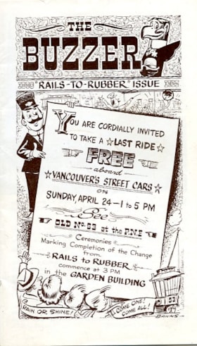
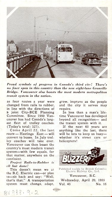
- "The Buzzer" was a weekly newsletter published by BC Electric Railway Co. and distributed on busses and streetcars. It gave weekly updates for transporation in the region. This Vol 40, No 16, for April 20, 1955. It is a special edition entitled "Rails to Rubber" and outlines the progress of the company and transporation from 1890 to 1955 when Street Cars were replaced with Busses. It advertises "YOU ARE CORDIALLY INVITED / TO TAKE A LAST RIDE / FREE / aboard / VANCOUVER'S STREET CARS / ON / SUNDAY, APRIL 24 - 1 to 5 PM / See / OLD No 53 at the P.N.E. / Cerimonies / Marking Completion of the Change / from / RAILS TO RUBBER / commence at 3 PM / in the GARDEN BUILDING"
- Category
- 08. Communication Artifacts
- Classification
- Documentary Artifacts - - Other Documents
- Object Term
- Serial
- Country Made
- Canada
- Province Made
- British Columbia
- Site/City Made
- Vancouver
- Patent Date
- 04/20/1955
- Subjects
- Transportation
- Transportation - Buses
Images


Boundary Road and Hastings Street vicinity
https://search.heritageburnaby.ca/link/archivedescription35447
- Repository
- City of Burnaby Archives
- Date
- 1915 (date of original), copied 1986
- Collection/Fonds
- Burnaby Historical Society fonds
- Description Level
- Item
- Physical Description
- 1 photograph : b&w ; 12.7 x 17.8 cm print
- Scope and Content
- Photograph taken in Vancouver on Hastings Street looking east toward Burnaby and Boundary Road. The Hastings Street British Columbia Electric Railway (BCER) cars can be seen labouring up the hill.
- Repository
- City of Burnaby Archives
- Date
- 1915 (date of original), copied 1986
- Collection/Fonds
- Burnaby Historical Society fonds
- Subseries
- Pioneer Tales subseries
- Physical Description
- 1 photograph : b&w ; 12.7 x 17.8 cm print
- Description Level
- Item
- Record No.
- 204-305
- Access Restriction
- No restrictions
- Reproduction Restriction
- No restrictions
- Accession Number
- BHS1988-03
- Scope and Content
- Photograph taken in Vancouver on Hastings Street looking east toward Burnaby and Boundary Road. The Hastings Street British Columbia Electric Railway (BCER) cars can be seen labouring up the hill.
- Media Type
- Photograph
- Photographer
- Eaton, Dr. Carl
- Notes
- Title based on contents of photograph
- Geographic Access
- Boundary Road
- Hastings Street
- Historic Neighbourhood
- Vancouver Heights (Historic Neighbourhood)
- Planning Study Area
- Willingdon Heights Area
Images

![Collision, [194-] thumbnail](/media/hpo/_Data/_Archives_Images/_Unrestricted/513/521-016.jpg?width=280)
Collision
https://search.heritageburnaby.ca/link/archivedescription65783
- Repository
- City of Burnaby Archives
- Date
- [194-]
- Collection/Fonds
- Field family fonds
- Description Level
- Item
- Physical Description
- 1 photograph (tiff) ; 600 ppi
- Scope and Content
- Photograph of spectators surrounding a collision involving a British Columbia Electric Railway tram and a car.
- Repository
- City of Burnaby Archives
- Date
- [194-]
- Collection/Fonds
- Field family fonds
- Physical Description
- 1 photograph (tiff) ; 600 ppi
- Material Details
- Item is a scan of a faded sepia photograph
- Description Level
- Item
- Record No.
- 521-016
- Access Restriction
- No restrictions
- Reproduction Restriction
- Reproduce for fair dealing purposes only
- Accession Number
- 2010-14
- Scope and Content
- Photograph of spectators surrounding a collision involving a British Columbia Electric Railway tram and a car.
- Media Type
- Photograph
- Notes
- Title based on contents of photograph
Images
![Collision, [194-] thumbnail](/media/hpo/_Data/_Archives_Images/_Unrestricted/513/521-016.jpg)
![Collision, [194-] thumbnail](/media/hpo/_Data/_Archives_Images/_Unrestricted/513/521-017.jpg?width=280)
Collision
https://search.heritageburnaby.ca/link/archivedescription65784
- Repository
- City of Burnaby Archives
- Date
- [194-]
- Collection/Fonds
- Field family fonds
- Description Level
- Item
- Physical Description
- 1 photograph (tiff) ; 600 ppi
- Scope and Content
- Photograph of a car and the damage it suffered in a collision involving a British Columbia Electric Railway tram.
- Repository
- City of Burnaby Archives
- Date
- [194-]
- Collection/Fonds
- Field family fonds
- Physical Description
- 1 photograph (tiff) ; 600 ppi
- Material Details
- Item is a scan of a b&w photograph
- Description Level
- Item
- Record No.
- 521-017
- Access Restriction
- No restrictions
- Reproduction Restriction
- Reproduce for fair dealing purposes only
- Accession Number
- 2010-14
- Scope and Content
- Photograph of a car and the damage it suffered in a collision involving a British Columbia Electric Railway tram.
- Media Type
- Photograph
- Notes
- Title based on contents of photograph
Images
![Collision, [194-] thumbnail](/media/hpo/_Data/_Archives_Images/_Unrestricted/513/521-017.jpg)
Cook for the electric railway workers
https://search.heritageburnaby.ca/link/archivedescription35838
- Repository
- City of Burnaby Archives
- Date
- 1914 (date of original), copied 1986
- Collection/Fonds
- Burnaby Historical Society fonds
- Description Level
- Item
- Physical Description
- 1 photograph : b&w ; 12.7 x 17.8 cm print
- Scope and Content
- Photograph of the cook, his wife, and Bill Hall (a childhood friend of Fred Holmes), who fed the crew installing British Columbia Electric Railway (BCER) power poles for the streetcar extension from Boundary Road to Ellesmere Avenue in 1914.
- Repository
- City of Burnaby Archives
- Date
- 1914 (date of original), copied 1986
- Collection/Fonds
- Burnaby Historical Society fonds
- Subseries
- Pioneer Tales subseries
- Physical Description
- 1 photograph : b&w ; 12.7 x 17.8 cm print
- Description Level
- Item
- Record No.
- 204-697
- Access Restriction
- No restrictions
- Reproduction Restriction
- No known restrictions
- Accession Number
- BHS1988-03
- Scope and Content
- Photograph of the cook, his wife, and Bill Hall (a childhood friend of Fred Holmes), who fed the crew installing British Columbia Electric Railway (BCER) power poles for the streetcar extension from Boundary Road to Ellesmere Avenue in 1914.
- Subjects
- Occupations - Cooks
- Names
- Hall, Bill
- Media Type
- Photograph
- Photographer
- Phillips, James William "Jim"
- Notes
- Title based on contents of photograph
- Historic Neighbourhood
- Capitol Hill (Historic Neighbourhood)
- Planning Study Area
- Capitol Hill Area
Images
![Esmond and Hastings Vicinity, [1915] (date of original), copied 1986 thumbnail](/media/hpo/_Data/_Archives_Images/_Unrestricted/204/204-306.jpg?width=280)
Esmond and Hastings Vicinity
https://search.heritageburnaby.ca/link/archivedescription35448
- Repository
- City of Burnaby Archives
- Date
- [1915] (date of original), copied 1986
- Collection/Fonds
- Burnaby Historical Society fonds
- Description Level
- Item
- Physical Description
- 1 photograph : b&w ; 12.7 x 17.8 cm print
- Scope and Content
- Photograph of the Arthur Wall Block (right), 3722 Hastings Street, at the corner of Hastings Street and Boundary Road, and the Matheson Block (left), 3730 Hastings Street. The British Columbia Electric Railway (BCER) Hastings car can be seen.
- Repository
- City of Burnaby Archives
- Date
- [1915] (date of original), copied 1986
- Collection/Fonds
- Burnaby Historical Society fonds
- Subseries
- Pioneer Tales subseries
- Physical Description
- 1 photograph : b&w ; 12.7 x 17.8 cm print
- Description Level
- Item
- Record No.
- 204-306
- Access Restriction
- No restrictions
- Reproduction Restriction
- No restrictions
- Accession Number
- BHS1988-03
- Scope and Content
- Photograph of the Arthur Wall Block (right), 3722 Hastings Street, at the corner of Hastings Street and Boundary Road, and the Matheson Block (left), 3730 Hastings Street. The British Columbia Electric Railway (BCER) Hastings car can be seen.
- Media Type
- Photograph
- Photographer
- Eaton, Dr. Carl
- Notes
- Title based on contents of photograph
- Geographic Access
- Hastings Street
- Street Address
- 3722 Hastings Street
- 3730 Hastings Street
- Historic Neighbourhood
- Vancouver Heights (Historic Neighbourhood)
- Planning Study Area
- Willingdon Heights Area
Images
![Esmond and Hastings Vicinity, [1915] (date of original), copied 1986 thumbnail](/media/hpo/_Data/_Archives_Images/_Unrestricted/204/204-306.jpg)
![From Antrim Avenue, [1943] (date of original), copied 1991 thumbnail](/media/hpo/_Data/_Archives_Images/_Unrestricted/370/370-656.jpg?width=280)
From Antrim Avenue
https://search.heritageburnaby.ca/link/archivedescription38069
- Repository
- City of Burnaby Archives
- Date
- [1943] (date of original), copied 1991
- Collection/Fonds
- Burnaby Historical Society fonds
- Description Level
- Item
- Physical Description
- 1 photograph : b&w ; 2.9 x 4.3 cm print on contact sheet 20.4 x 26.5 cm
- Scope and Content
- Photograph taken looking south from the back of 2224 Antrim Avenue (later renumbered 6957 Antrim Avenue). The British Columbia Electric Railway Company tracks and Central Park tram are partially visible in the background.
- Repository
- City of Burnaby Archives
- Date
- [1943] (date of original), copied 1991
- Collection/Fonds
- Burnaby Historical Society fonds
- Subseries
- Burnaby Image Bank subseries
- Physical Description
- 1 photograph : b&w ; 2.9 x 4.3 cm print on contact sheet 20.4 x 26.5 cm
- Description Level
- Item
- Record No.
- 370-656
- Access Restriction
- No restrictions
- Reproduction Restriction
- No known restrictions
- Accession Number
- BHS1999-03
- Scope and Content
- Photograph taken looking south from the back of 2224 Antrim Avenue (later renumbered 6957 Antrim Avenue). The British Columbia Electric Railway Company tracks and Central Park tram are partially visible in the background.
- Subjects
- Plants - Trees
- Media Type
- Photograph
- Notes
- Title based on contents of photograph
- 1 b&w copy negative accompanying
- Negative has a pink cast
- Geographic Access
- Antrim Avenue
- Street Address
- 6957 Antrim Avenue
- Historic Neighbourhood
- Central Park (Historic Neighbourhood)
- Planning Study Area
- Windsor Area
Images
![From Antrim Avenue, [1943] (date of original), copied 1991 thumbnail](/media/hpo/_Data/_Archives_Images/_Unrestricted/370/370-656.jpg)
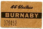
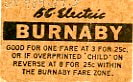
interurban ticket
https://search.heritageburnaby.ca/link/museumartifact3337
- Repository
- Burnaby Village Museum
- Accession Code
- BV989.37.5
- Description
- B.C. Electric Burnaby - Ticket. Brown coloured ticket for the British Columbia Electric Railway in Burnaby. The ticket is good for one Adult's fare at 3 for 25 cents within the the Burnaby fare zone. The ticket states that the fare would be good for a child if the ticket was over printed with "CHILD". Stamped on the front of the ticket is "379452". The ticket measures 3.5cm x 2cm.
- Object History
- Object was acquired by donor from the estate of his sister-in-law, Jean Low Scott, a long-time Burnaby resident.
- Colour
- Brown
- Subjects
- Exchange Medium
- Exchange Medium - Tickets
- Transportation
- Transportation - Electric Railroads
Images
![Interurban tram 1223 dedication plaque, April 24, 1966 (date of original), copied [199-?] thumbnail](/media/Hpo/_Data/_Archives_Images/_Unrestricted/001/066-015.jpg?width=280)
Interurban tram 1223 dedication plaque
https://search.heritageburnaby.ca/link/archivedescription34611
- Repository
- City of Burnaby Archives
- Date
- April 24, 1966 (date of original), copied [199-?]
- Collection/Fonds
- Burnaby Historical Society fonds
- Description Level
- Item
- Physical Description
- 1 photograph : b&w negative ; 6.3 x 6.1 cm
- Scope and Content
- Photograph of the dedication plaque on Interurban tram no. 1223: "This interurban tram car was built in 1913 be the St. Louis Car Co. for The British Columbia Electric Railway Co. and operated over that company's three lines in Burnaby until abandonment, November 17th 1956. Throughout the nearly f…
- Repository
- City of Burnaby Archives
- Date
- April 24, 1966 (date of original), copied [199-?]
- Collection/Fonds
- Burnaby Historical Society fonds
- Subseries
- Photographs subseries
- Physical Description
- 1 photograph : b&w negative ; 6.3 x 6.1 cm
- Description Level
- Item
- Record No.
- 066-015
- Access Restriction
- No restrictions
- Reproduction Restriction
- Reproduce for fair dealing purposes only
- Accession Number
- BHS2007-04
- Scope and Content
- Photograph of the dedication plaque on Interurban tram no. 1223: "This interurban tram car was built in 1913 be the St. Louis Car Co. for The British Columbia Electric Railway Co. and operated over that company's three lines in Burnaby until abandonment, November 17th 1956. Throughout the nearly fifty years of its existence this tram and seventy similar cars carried many thousands of settlers and commuters and helped to build Burnaby into a thriving community of over 80,000." / "Dedicated and placed here by Burnaby Historical Society, Nov. 30th 1958." The tram was displayed at the Edmonds Bus Loop at Edmonds Street and Kingsway.
- Subjects
- Transportation - Electric Railroads
- Media Type
- Photograph
- Notes
- Title based on contents of photograph
- 1 b&w photograph accompanying
- Geographic Access
- Kingsway
- Edmonds Street
- Historic Neighbourhood
- Edmonds (Historic Neighbourhood)
- Planning Study Area
- Stride Avenue Area
Images
![Interurban tram 1223 dedication plaque, April 24, 1966 (date of original), copied [199-?] thumbnail](/media/Hpo/_Data/_Archives_Images/_Unrestricted/001/066-015.jpg)
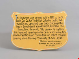
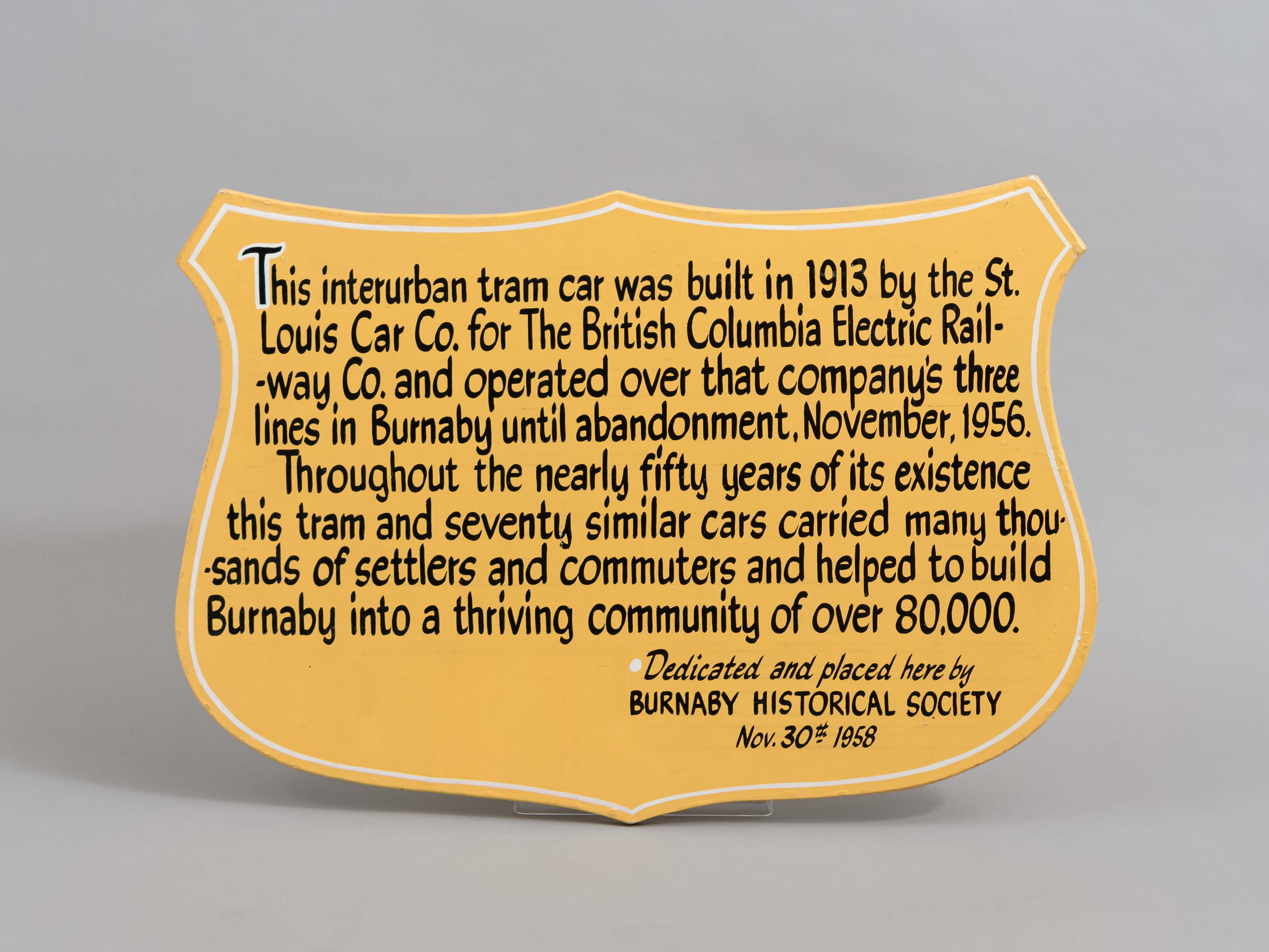
plaque
https://search.heritageburnaby.ca/link/museumartifact36450
- Repository
- Burnaby Village Museum
- Accession Code
- BV994.38.1
- Description
- Plaque. Badge shaped, made of ply-wooden, the background is painted yellow/tan and the lettering is black.
- Object History
- The plaque commemorates the history of the British Columbia Electric Railway in Burnaby, and the preservation of tram #1223 by the Burnaby Historical Society in 1958. Interurban tram No. 1223 has been restored by the joint efforts of the Friends of 1223 and Burnaby Village Museum. In March 2007 the tram was officially returned to Burnaby Village Museum and is currently on display, in a replica of a Tram Car Barn, at the Museum.
- Fraser Wilson hand lettered the sign.
- Marks/Labels
- "This Interurban Tram Car was built in 1913 by the St. Louis Car Co. for the British Columbia Electric Railway Co. and operated over that company's three lines in Burnaby until abandonment, November 1956. Throughout the nearly fifty years of its existence this tram and seventy similar cars carried many thousands of settlers and commuters and helped to build Burnaby into a thriving community of over 80,000"; "Dedicated and placed here by Burnaby Historical Society. Nov. 30th 1958", hand lettered.
- Subjects
- Transportation
- Transportation - Public Transit
- Transportation - Electric Railroads
- Advertising Medium
- Advertising Medium - Signs and Signboards
Images
![Tram car plaque, [1971] thumbnail](/media/hpo/_Data/_BVM_Images/2005/2005_0054_0420_001.jpg?width=280)
Tram car plaque
https://search.heritageburnaby.ca/link/museumdescription2374
- Repository
- Burnaby Village Museum
- Date
- [1971]
- Collection/Fonds
- Donald Copan collection
- Description Level
- Item
- Physical Description
- 1 photograph : b&w ; 8.9 x 12.7 cm
- Scope and Content
- Photograph of the dedication plaque mounted on Interurban tram car no. 1223. The plaque reads: "This interurban tram car was built in 1913 be the St. Louis Car Co. for The British Columbia Electric Railway Co. and operated over that company's three lines in Burnaby until abandonment, November 17th …
- Repository
- Burnaby Village Museum
- Collection/Fonds
- Donald Copan collection
- Series
- Copan album series
- Description Level
- Item
- Physical Description
- 1 photograph : b&w ; 8.9 x 12.7 cm
- Scope and Content
- Photograph of the dedication plaque mounted on Interurban tram car no. 1223. The plaque reads: "This interurban tram car was built in 1913 be the St. Louis Car Co. for The British Columbia Electric Railway Co. and operated over that company's three lines in Burnaby until abandonment, November 17th 1956. Throughout the nearly fifty years of its existence this tram and seventy similar cars carried many thousands of settlers and commuters and helped to build Burnaby into a thriving community of over 80,000." / "Dedicated and placed here by Burnaby Historical Society, Nov. 30th 1958." The tram was displayed at the Edmonds Bus Loop at Edmonds Street and Kingsway.
- Subjects
- Transportation - Electric Railroads
- Geographic Access
- Kingsway
- Accession Code
- BV005.54.420
- Access Restriction
- No restrictions
- Reproduction Restriction
- May be restricted by third party rights
- Date
- [1971]
- Media Type
- Photograph
- Historic Neighbourhood
- Edmonds (Historic Neighbourhood)
- Planning Study Area
- Stride Avenue Area
- Scan Resolution
- 600
- Scan Date
- August 11, 2020
- Scale
- 100
- Notes
- Title based on contents of photograph
Images
![Tram car plaque, [1971] thumbnail](/media/hpo/_Data/_BVM_Images/2005/2005_0054_0420_001.jpg)