Narrow Results By
Subject
- Advertising Medium - Signs and Signboards 7
- Agriculture - Farms 4
- Agriculture - Fruit and Berries 3
- Animals - Birds 1
- Animals - Horses 1
- Arts 2
- Arts - Drawings 1
- Arts - Sculptures 1
- Buildings - Civic 1
- Buildings - Civic - Hospitals 2
- Buildings - Civic - Museums 8
- Buildings - Commercial - Automobile Dealerships 2
![British Columbia Electric Railway Company timetables, [between 1946 and 1973] thumbnail](/media/hpo/_Data/_BVM_Images/1973/1973_0041_0005_001.jpg?width=280)
British Columbia Electric Railway Company timetables
https://search.heritageburnaby.ca/link/museumdescription996
- Repository
- Burnaby Village Museum
- Date
- [between 1946 and 1973]
- Collection/Fonds
- Burnaby Village Museum Photograph collection
- Description Level
- Item
- Physical Description
- 1 photograph : b&w ; 20.4 x 25.3 cm
- Scope and Content
- Photograph of a BC Electric Railway timetable for the Lulu Island Branch, Eburne, and New Westminster Line, including a Sunday schedule and freight schedule.
- Repository
- Burnaby Village Museum
- Collection/Fonds
- Burnaby Village Museum Photograph collection
- Description Level
- Item
- Physical Description
- 1 photograph : b&w ; 20.4 x 25.3 cm
- Scope and Content
- Photograph of a BC Electric Railway timetable for the Lulu Island Branch, Eburne, and New Westminster Line, including a Sunday schedule and freight schedule.
- Accession Code
- HV973.41.5
- Access Restriction
- No restrictions
- Reproduction Restriction
- May be restricted by third party rights
- Date
- [between 1946 and 1973]
- Media Type
- Photograph
- Related Material
- For an earlier donation made by the same donor in regards to BCER tram, see accession HV972.202.
- Scan Resolution
- 300
- Scan Date
- 2023-05-16
- Notes
- Title based on contents of photograph
Images
![British Columbia Electric Railway Company timetables, [between 1946 and 1973] thumbnail](/media/hpo/_Data/_BVM_Images/1973/1973_0041_0005_001.jpg)
![British Columbia Electric Railway Company timetables, [between 1946 and 1973] thumbnail](/media/hpo/_Data/_BVM_Images/1973/1973_0041_0006_001.jpg?width=280)
British Columbia Electric Railway Company timetables
https://search.heritageburnaby.ca/link/museumdescription997
- Repository
- Burnaby Village Museum
- Date
- [between 1946 and 1973]
- Collection/Fonds
- Burnaby Village Museum Photograph collection
- Description Level
- Item
- Physical Description
- 1 photograph : b&w ; 25.4 x 20.6 cm
- Scope and Content
- Photograph of two British Columbia Electric Railway Company timetables for the Central Park line, one "corrected to October 15, 1933" and the other "corrected to May 16, 1946." Also in the photograph are two tickets, one reads, "Good for one fare at 10 for $1.25 between Vancouver and Burnaby North…
- Repository
- Burnaby Village Museum
- Collection/Fonds
- Burnaby Village Museum Photograph collection
- Description Level
- Item
- Physical Description
- 1 photograph : b&w ; 25.4 x 20.6 cm
- Scope and Content
- Photograph of two British Columbia Electric Railway Company timetables for the Central Park line, one "corrected to October 15, 1933" and the other "corrected to May 16, 1946." Also in the photograph are two tickets, one reads, "Good for one fare at 10 for $1.25 between Vancouver and Burnaby Northwest Zone" and the other reads, "Good for one fare between Vancouver and Park Ave."
- Accession Code
- HV973.41.6
- Access Restriction
- No restrictions
- Reproduction Restriction
- May be restricted by third party rights
- Date
- [between 1946 and 1973]
- Media Type
- Photograph
- Related Material
- For an earlier donation made by the same donor in regards to BCER tram, see accession HV972.202.
- Scan Resolution
- 300
- Scan Date
- 2023-05-16
- Notes
- Title based on contents of photograph
Images
![British Columbia Electric Railway Company timetables, [between 1946 and 1973] thumbnail](/media/hpo/_Data/_BVM_Images/1973/1973_0041_0006_001.jpg)
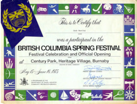
British Columbia Spring Festival certificate
https://search.heritageburnaby.ca/link/museumdescription16731
- Repository
- Burnaby Village Museum
- Date
- 1975
- Collection/Fonds
- Century Park Museum Association fonds
- Description Level
- Item
- Physical Description
- 1p.
- Scope and Content
- Items consists of a certificate awarded to Jack Barclay as a participant in the British Columbia Spring Festival, Festival Celebration and Official Opening at Century Park, Heritage Village, Burnaby. The certificate is dated May 15-June 16, 1975 and is signed by Premier Honary Chairman, Dave Barret…
- Repository
- Burnaby Village Museum
- Collection/Fonds
- Century Park Museum Association fonds
- Description Level
- Item
- Physical Description
- 1p.
- Scope and Content
- Items consists of a certificate awarded to Jack Barclay as a participant in the British Columbia Spring Festival, Festival Celebration and Official Opening at Century Park, Heritage Village, Burnaby. The certificate is dated May 15-June 16, 1975 and is signed by Premier Honary Chairman, Dave Barrett; Provincial Secretary, Honorary President, G. Hall [sic]; Festival General Chairman, B.L. Colby.
- Subjects
- Documentary Artifacts - Certificates
- Accession Code
- BV020.5.1802
- Access Restriction
- No restrictions
- Reproduction Restriction
- No known restrictions
- Date
- 1975
- Media Type
- Textual Record
- Scan Resolution
- 600
- Scan Date
- June 18, 2021
- Scale
- 100
- Notes
- Title based on contents of item
Images

Sketch map of the Province of British Columbia showing mining divisions
https://search.heritageburnaby.ca/link/museumdescription18946
- Repository
- Burnaby Village Museum
- Date
- 1907
- Collection/Fonds
- Burnaby Village Museum Map collection
- Description Level
- Item
- Physical Description
- 1 map : col. lithographic print on paper ; 52 x 59 cm
- Scope and Content
- Item consists of a map titled "Sketch map of the Province of / British Columbia / Showing Mining Divisions"; "Department of Mines, / Victoria, 1907". Map includes wagon roads and trails and geographic disticts.
- Repository
- Burnaby Village Museum
- Collection/Fonds
- Burnaby Village Museum Map collection
- Description Level
- Item
- Physical Description
- 1 map : col. lithographic print on paper ; 52 x 59 cm
- Material Details
- Scale not determinable
- Scope and Content
- Item consists of a map titled "Sketch map of the Province of / British Columbia / Showing Mining Divisions"; "Department of Mines, / Victoria, 1907". Map includes wagon roads and trails and geographic disticts.
- Accession Code
- HV977.37.172
- Access Restriction
- No restrictions
- Reproduction Restriction
- No known restrictions
- Date
- 1907
- Media Type
- Cartographic Material
- Scan Resolution
- 600
- Scan Date
- 2023-08-17
- Notes
- Title based on contents of map
- Stamp on verso of map reads: "Compliments of Vancouver Tourist Bureau"
Zoomable Images


Angus & Margaret MacDonald House
https://search.heritageburnaby.ca/link/landmark495
- Repository
- Burnaby Heritage Planning
- Description
- Set on a large corner lot at North Esmond Avenue and Oxford Street, the Angus & Margaret MacDonald House is a prominent, two and one-half storey Queen Anne Revival-style residence. The high hipped roof has open projecting gables. The house is a landmark within the Vancouver Heights neighbourhood of…
- Associated Dates
- 1909
- Formal Recognition
- Heritage Designation, Community Heritage Register
- Street View URL
- Google Maps Street View
- Repository
- Burnaby Heritage Planning
- Geographic Access
- Oxford Street
- Associated Dates
- 1909
- Formal Recognition
- Heritage Designation, Community Heritage Register
- Enactment Type
- Bylaw No. 12174
- Enactment Date
- 11/12/2006
- Description
- Set on a large corner lot at North Esmond Avenue and Oxford Street, the Angus & Margaret MacDonald House is a prominent, two and one-half storey Queen Anne Revival-style residence. The high hipped roof has open projecting gables. The house is a landmark within the Vancouver Heights neighbourhood of North Burnaby, on a high point of land overlooking Burrard Inlet and the North Shore Mountains.
- Heritage Value
- The MacDonald House is valued as one of Burnaby’s most elaborate examples of the Queen Anne Revival style. The house retains many of its original features, including a prominent front corner turret wrapped by a clamshell verandah. The eclectic and transitional nature of Edwardian-era architecture is demonstrated by the late persistence of these Queen Anne Revival details, combined with the use of newly-popular classical revival elements such as Ionic columns. The interior retains a number of original architectural elements, and the early garage at the rear originally housed Angus MacDonald’s Cadillac, one of the first known automobiles owned by a Burnaby resident. Constructed in 1909, this house was built for Angus MacDonald (1857-1943) and his wife, Margaret Isabella Thompson MacDonald (1862-1939). Angus MacDonald, an electrical contractor, relocated from Nova Scotia to Vancouver in 1891 and served on Vancouver Council from 1904-08. The MacDonald family moved to Burnaby upon his retirement from the B.C. Electric Railway Company, and he then served the North Burnaby Ward as a councillor from 1911-1916 and again in 1921. MacDonald Street in Burnaby was named in his honour. The MacDonald House has additional significance as one of the surviving landmark residences, built between 1909 and 1914, during the first development of Vancouver Heights. In 1909, C.J. Peter and his employer, G.F. and J. Galt Limited, initiated the development of this North Burnaby neighbourhood, promoting it as one of the most picturesque districts in the region and an alternative to the CPR’s prestigious Shaughnessy Heights development in Vancouver. Buyers were obligated to build houses worth $3,500 at a time when the average house price was $1,000. Reputed to be the second house built in the subdivision, this house cost $7,000 to build.
- Defining Elements
- Key elements that define the heritage character of the MacDonald House include its: - prominent corner location in the Vancouver Heights neighbourhood, with views to Burrard Inlet and the North Shore Mountains - residential form, scale and massing as exemplified by its two and one-half storey height, full basement, compound plan, and high hipped roof with gabled projections at the front and side - wood-frame construction including wooden lapped siding, trim and mouldings - rubble-stone granite foundation - Queen Anne Revival details such as scroll-cut modillions, octagonal corner turret, wraparound, clamshell verandah with classical columns, and projecting square and semi-octagonal bays - external red-brick chimney with corbelled top - original windows including double-hung, 1-over-1 wooden sash windows in single and double assembly, and arched-top casement windows in the gable peaks - original interior features such as the main staircase, a panelled dining room with a fireplace and built-in cabinets, a living room with a parquet floor, and a rear den with an oak mantle and tiled hearth - associated early wood-frame garage at the rear of the property - landscape features such as mature coniferous and deciduous trees surrounding the property
- Historic Neighbourhood
- Vancouver Heights (Historic Neighbourhood)
- Planning Study Area
- Burnaby Heights Area
- Organization
- British Columbia Mills Timber and Trading Company
- Function
- Primary Historic--Single Dwelling
- Primary Current--Single Dwelling
- Community
- Vancouver Heights
- Cadastral Identifier
- P.I.D.011-999-462
- Boundaries
- The MacDonald House is comprised of a single residential lot located at 3814 Oxford Street, Burnaby.
- Area
- 566.71
- Contributing Resource
- Building
- Ownership
- Private
- Documentation
- City of Burnaby Planning and Building Department, Heritage Site Files
- Street Address
- 3814 Oxford Street
- Street View URL
- Google Maps Street View
Images


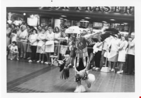
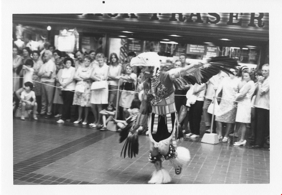
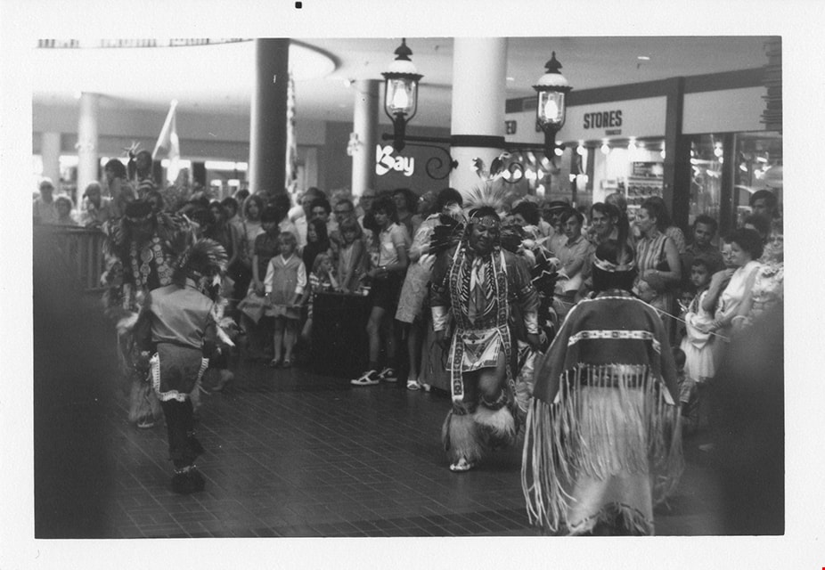
Indigenous dancer at Brentwood mall
https://search.heritageburnaby.ca/link/museumdescription13235
- Repository
- Burnaby Village Museum
- Date
- 1971
- Collection/Fonds
- Donald Copan collection
- Description Level
- Item
- Physical Description
- 1 photograph : b&w ; 8.9 x 12.7 cm
- Scope and Content
- Photograph of an Indigenous person in traditional clothing and dancing inside Brentwood Mall. A large group of people have gathered around to watch.
- Repository
- Burnaby Village Museum
- Collection/Fonds
- Donald Copan collection
- Series
- Copan album series
- Description Level
- Item
- Physical Description
- 1 photograph : b&w ; 8.9 x 12.7 cm
- Scope and Content
- Photograph of an Indigenous person in traditional clothing and dancing inside Brentwood Mall. A large group of people have gathered around to watch.
- Subjects
- Indigenous peoples - British Columbia
- Indigenous peoples - British Columbia - Rites and ceremonies
- Indigenous peoples - Clothing
- Buildings - Commercial - Malls
- Geographic Access
- Lougheed Highway
- Street Address
- 4567 Lougheed Highway
- Accession Code
- BV005.54.246
- Access Restriction
- Restricted access
- Reproduction Restriction
- May be restricted by third party rights
- Date
- 1971
- Media Type
- Photograph
- Planning Study Area
- Brentwood Area
- Scan Resolution
- 600
- Scan Date
- July 23, 2020
- Scale
- 100
- Notes
- Title based on contents of photograph
Images

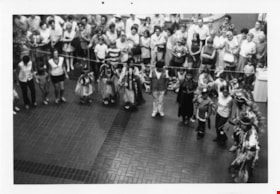
Indigenous dancers at Brentwood mall
https://search.heritageburnaby.ca/link/museumdescription2195
- Repository
- Burnaby Village Museum
- Date
- 1971
- Collection/Fonds
- Donald Copan collection
- Description Level
- Item
- Physical Description
- 1 photograph : b&w ; 8.9 x 12.7 cm
- Scope and Content
- Photograph of Indigenous peoples dressed in traditional clothing and dancing inside Brentwood Mall. A large group of people have gathered around to watch.
- Repository
- Burnaby Village Museum
- Collection/Fonds
- Donald Copan collection
- Series
- Copan album series
- Description Level
- Item
- Physical Description
- 1 photograph : b&w ; 8.9 x 12.7 cm
- Scope and Content
- Photograph of Indigenous peoples dressed in traditional clothing and dancing inside Brentwood Mall. A large group of people have gathered around to watch.
- Subjects
- Indigenous peoples - British Columbia
- Indigenous peoples - British Columbia - Rites and ceremonies
- Indigenous peoples - Clothing
- Buildings - Commercial - Malls
- Geographic Access
- Lougheed Highway
- Street Address
- 4567 Lougheed Highway
- Accession Code
- BV005.54.243
- Access Restriction
- No restrictions
- Reproduction Restriction
- May be restricted by third party rights
- Date
- 1971
- Media Type
- Photograph
- Planning Study Area
- Brentwood Area
- Scan Resolution
- 600
- Scan Date
- July 23, 2020
- Scale
- 100
- Notes
- Title based on contents of photograph
Images
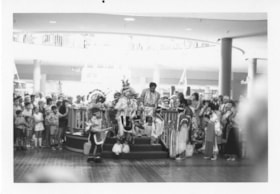
Indigenous dancers at Brentwood mall
https://search.heritageburnaby.ca/link/museumdescription13233
- Repository
- Burnaby Village Museum
- Date
- 1971
- Collection/Fonds
- Donald Copan collection
- Description Level
- Item
- Physical Description
- 1 photograph : b&w ; 8.9 x 12.7 cm
- Scope and Content
- Photograph of Indigenous peoples dressed in traditional clothing and dancing inside Brentwood Mall. A large group of people have gathered around to watch.
- Repository
- Burnaby Village Museum
- Collection/Fonds
- Donald Copan collection
- Series
- Copan album series
- Description Level
- Item
- Physical Description
- 1 photograph : b&w ; 8.9 x 12.7 cm
- Scope and Content
- Photograph of Indigenous peoples dressed in traditional clothing and dancing inside Brentwood Mall. A large group of people have gathered around to watch.
- Subjects
- Indigenous peoples - British Columbia
- Indigenous peoples - British Columbia - Rites and ceremonies
- Indigenous peoples - Clothing
- Buildings - Commercial - Malls
- Geographic Access
- Lougheed Highway
- Street Address
- 4567 Lougheed Highway
- Accession Code
- BV005.54.244
- Access Restriction
- Restricted access
- Reproduction Restriction
- May be restricted by third party rights
- Date
- 1971
- Media Type
- Photograph
- Planning Study Area
- Brentwood Area
- Scan Resolution
- 600
- Scan Date
- July 23, 2020
- Scale
- 100
- Notes
- Title based on contents of photograph
Images

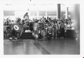
Indigenous dancers at Brentwood mall
https://search.heritageburnaby.ca/link/museumdescription13234
- Repository
- Burnaby Village Museum
- Date
- 1971
- Collection/Fonds
- Donald Copan collection
- Description Level
- Item
- Physical Description
- 1 photograph : b&w ; 8.9 x 12.7 cm
- Scope and Content
- Photograph of Indigenous peoples dressed in traditional clothing and dancing inside Brentwood Mall. A large group of people have gathered around to watch.
- Repository
- Burnaby Village Museum
- Collection/Fonds
- Donald Copan collection
- Series
- Copan album series
- Description Level
- Item
- Physical Description
- 1 photograph : b&w ; 8.9 x 12.7 cm
- Scope and Content
- Photograph of Indigenous peoples dressed in traditional clothing and dancing inside Brentwood Mall. A large group of people have gathered around to watch.
- Subjects
- Indigenous peoples - British Columbia
- Indigenous peoples - British Columbia - Rites and ceremonies
- Indigenous peoples - Clothing
- Buildings - Commercial - Malls
- Geographic Access
- Lougheed Highway
- Street Address
- 4567 Lougheed Highway
- Accession Code
- BV005.54.245
- Access Restriction
- Restricted access
- Reproduction Restriction
- May be restricted by third party rights
- Date
- 1971
- Media Type
- Photograph
- Planning Study Area
- Brentwood Area
- Scan Resolution
- 600
- Scan Date
- July 23, 2020
- Scale
- 100
- Notes
- Title based on contents of photograph
Images

Indigenous dancers at Brentwood mall
https://search.heritageburnaby.ca/link/museumdescription13236
- Repository
- Burnaby Village Museum
- Date
- 1971
- Collection/Fonds
- Donald Copan collection
- Description Level
- Item
- Physical Description
- 1 photograph : b&w ; 8.9 x 12.7 cm
- Scope and Content
- Photograph of an Indigenous peoples gathered in a circle with non-indigenous people inside Brentwood Mall. Indigenous peoples are dressed in traditional clothing. A large group of people have gathered around to watch.
- Repository
- Burnaby Village Museum
- Collection/Fonds
- Donald Copan collection
- Series
- Copan album series
- Description Level
- Item
- Physical Description
- 1 photograph : b&w ; 8.9 x 12.7 cm
- Scope and Content
- Photograph of an Indigenous peoples gathered in a circle with non-indigenous people inside Brentwood Mall. Indigenous peoples are dressed in traditional clothing. A large group of people have gathered around to watch.
- Subjects
- Indigenous peoples - British Columbia
- Indigenous peoples - British Columbia - Rites and ceremonies
- Indigenous peoples - Clothing
- Buildings - Commercial - Malls
- Geographic Access
- Lougheed Highway
- Street Address
- 4567 Lougheed Highway
- Accession Code
- BV005.54.247
- Access Restriction
- Restricted access
- Reproduction Restriction
- May be restricted by third party rights
- Date
- 1971
- Media Type
- Photograph
- Planning Study Area
- Brentwood Area
- Scan Resolution
- 600
- Scan Date
- July 23, 2020
- Scale
- 100
- Notes
- Title based on contents of photograph
Images

Costumed people at opening of Heritage Village
https://search.heritageburnaby.ca/link/museumdescription2404
- Repository
- Burnaby Village Museum
- Date
- 19 November 1971
- Collection/Fonds
- Donald Copan collection
- Description Level
- Item
- Physical Description
- 1 photograph : col. ; 8.9 x 8.9 cm
- Scope and Content
- Photograph of costumed people gathered outside of "The Buggy Shop" during opening day ceremonies for Heritage Village (now Burnaby Village Museum). Mrs. Alice Burritt, Mrs. Centennial of Canada, 1967 is dressed in traditional indigenous clothing and standing next to three young women that are weari…
- Repository
- Burnaby Village Museum
- Collection/Fonds
- Donald Copan collection
- Series
- Copan album series
- Description Level
- Item
- Physical Description
- 1 photograph : col. ; 8.9 x 8.9 cm
- Scope and Content
- Photograph of costumed people gathered outside of "The Buggy Shop" during opening day ceremonies for Heritage Village (now Burnaby Village Museum). Mrs. Alice Burritt, Mrs. Centennial of Canada, 1967 is dressed in traditional indigenous clothing and standing next to three young women that are wearing full length dresses, crowns and banners which read "Miss B.C. Centennial" next to an unidentified man dressed in tales and a top hat.
- Subjects
- Events - Openings
- Buildings - Civic - Museums
- Indigenous peoples - British Columbia
- Indigenous peoples - Clothing
- Accession Code
- BV005.54.450
- Access Restriction
- No restrictions
- Reproduction Restriction
- May be restricted by third party rights
- Date
- 19 November 1971
- Media Type
- Photograph
- Scan Resolution
- 600
- Scan Date
- August 11, 2020
- Scale
- 100
- Notes
- Title based on contents of photograph
Images
Costumed people at opening of Heritage Village
https://search.heritageburnaby.ca/link/museumdescription13599
- Repository
- Burnaby Village Museum
- Date
- 19 November 1971
- Collection/Fonds
- Donald Copan collection
- Description Level
- Item
- Physical Description
- 1 photograph : b&w ; 8.9 x 12.7 cm
- Scope and Content
- Photograph of costumed people gathered outside of "The Buggy Shop" during opening day ceremonies for Heritage Village (now Burnaby Village Museum). Mrs. Alice Burritt, Mrs. Centennial of Canada, 1967 is dressed in traditional indigenous clothing and standing next to three young women that are weari…
- Repository
- Burnaby Village Museum
- Collection/Fonds
- Donald Copan collection
- Series
- Copan album series
- Description Level
- Item
- Physical Description
- 1 photograph : b&w ; 8.9 x 12.7 cm
- Scope and Content
- Photograph of costumed people gathered outside of "The Buggy Shop" during opening day ceremonies for Heritage Village (now Burnaby Village Museum). Mrs. Alice Burritt, Mrs. Centennial of Canada, 1967 is dressed in traditional indigenous clothing and standing next to three young women that are wearing full length dresses, crowns and banners which read "Miss B.C. Centennial" next to an unidentified man dressed in tales and a top hat.
- Subjects
- Events - Openings
- Buildings - Civic - Museums
- Indigenous peoples - British Columbia
- Indigenous peoples - Clothing
- Accession Code
- BV005.54.491
- Access Restriction
- No restrictions
- Reproduction Restriction
- May be restricted by third party rights
- Date
- 19 November 1971
- Media Type
- Photograph
- Scan Resolution
- 600
- Scan Date
- August 11, 2020
- Scale
- 100
- Notes
- Title based on contents of photograph
Images
Dignitaries at opening of Heritage Village
https://search.heritageburnaby.ca/link/museumdescription2412
- Repository
- Burnaby Village Museum
- Date
- 19 November 1971
- Collection/Fonds
- Donald Copan collection
- Description Level
- Item
- Physical Description
- 1 photograph : col. ; 8.9 x 8.9 cm
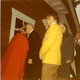
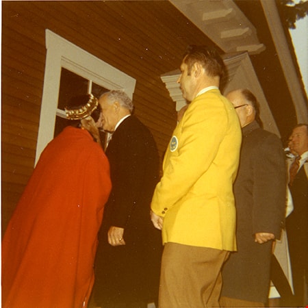
- Scope and Content
- Photograph of dignitaries at opening of Heritage Village (now Burnaby Village Museum) on November 19, 1971. Mrs. Alice Burritt, Mrs. Centennial of Canada, 1967 (dressed in traditional indigenous clothing) greets Governor-General Roland Michener (in black suit) with a kiss on the cheek. Members of t…
- Repository
- Burnaby Village Museum
- Collection/Fonds
- Donald Copan collection
- Series
- Copan album series
- Description Level
- Item
- Physical Description
- 1 photograph : col. ; 8.9 x 8.9 cm
- Scope and Content
- Photograph of dignitaries at opening of Heritage Village (now Burnaby Village Museum) on November 19, 1971. Mrs. Alice Burritt, Mrs. Centennial of Canada, 1967 (dressed in traditional indigenous clothing) greets Governor-General Roland Michener (in black suit) with a kiss on the cheek. Members of the Burnaby Centennial '71 Committee and guests are standing behind.
- Subjects
- Events - Openings
- Celebrations - Centennials
- Events
- Indigenous peoples - British Columbia
- Indigenous peoples - Clothing
- Accession Code
- BV005.54.458
- Access Restriction
- No restrictions
- Reproduction Restriction
- May be restricted by third party rights
- Date
- 19 November 1971
- Media Type
- Photograph
- Scan Resolution
- 600
- Scan Date
- August 11, 2020
- Scale
- 100
- Notes
- Title based on contents of photograph
Images
Dignitaries at opening of Heritage Village
https://search.heritageburnaby.ca/link/museumdescription13803
- Repository
- Burnaby Village Museum
- Date
- 19 November 1971
- Collection/Fonds
- Donald Copan collection
- Description Level
- Item
- Physical Description
- 1 photograph : b&w ; 8.9 x 12.7 cm
- Scope and Content
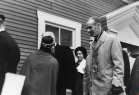
- Photograph of dignitaries at opening of Heritage Village (now Burnaby Village Museum) on November 19, 1971. Mrs. Alice Burritt, Mrs. Centennial of Canada, 1967 (dressed in traditional indigenous clothing) greets Governor-General Roland Michener (in black suit) with a kiss on the cheek. Mayor Bob Pr…
- Repository
- Burnaby Village Museum
- Collection/Fonds
- Donald Copan collection
- Series
- Copan album series
- Description Level
- Item
- Physical Description
- 1 photograph : b&w ; 8.9 x 12.7 cm
- Scope and Content
- Photograph of dignitaries at opening of Heritage Village (now Burnaby Village Museum) on November 19, 1971. Mrs. Alice Burritt, Mrs. Centennial of Canada, 1967 (dressed in traditional indigenous clothing) greets Governor-General Roland Michener (in black suit) with a kiss on the cheek. Mayor Bob Prittie (right) and members of the Burnaby Centennial '71 Committee and guests are standing behind.
- Subjects
- Events - Openings
- Persons - Crowds
- Indigenous peoples - British Columbia
- Buildings - Civic - Museums
- Indigenous peoples - Clothing
- Names
- Burnaby Village Museum
- Prittie, Robert W. "Bob"
- Michener, Daniel Roland "Roland"
- Burritt, Alice
- Accession Code
- BV005.54.604
- Access Restriction
- No restrictions
- Reproduction Restriction
- May be restricted by third party rights
- Date
- 19 November 1971
- Media Type
- Photograph
- Scan Resolution
- 600
- Scan Date
- 18-Aug-2020
- Scale
- 100
- Notes
- Title based on contents of photograph
- Description information gathered from page 42 of The Province newspaper Nov. 20, 1971. Newpaper article by Helen Bateson, headline reads "In the 'heavenly dew'"
Images
Governor General Roland Michener and Mrs. Alice Burritt at Heritage Village opening
https://search.heritageburnaby.ca/link/museumdescription13805
- Repository
- Burnaby Village Museum
- Date
- 19 November 1971
- Collection/Fonds
- Donald Copan collection
- Description Level
- Item
- Physical Description
- 1 photograph : b&w ; 8.9 x 12.7 cm
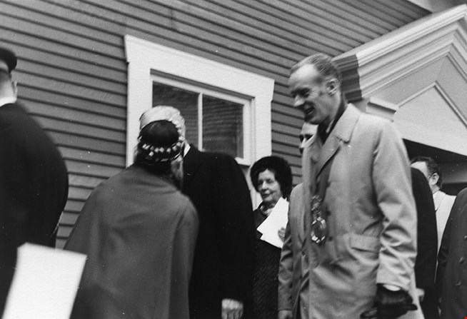
- Scope and Content
- Photograph of Mrs. Alice Burritt, Mrs. Centennial of Canada, 1967 (dressed in traditional indigenous clothing) greeting Governor-General Roland Michener with a handshake at the official opening of Heritage Village. Mayor Bob Prittie (right) and members of the Burnaby Centennial '71 Committee and gu…
- Repository
- Burnaby Village Museum
- Collection/Fonds
- Donald Copan collection
- Series
- Copan album series
- Description Level
- Item
- Physical Description
- 1 photograph : b&w ; 8.9 x 12.7 cm
- Scope and Content
- Photograph of Mrs. Alice Burritt, Mrs. Centennial of Canada, 1967 (dressed in traditional indigenous clothing) greeting Governor-General Roland Michener with a handshake at the official opening of Heritage Village. Mayor Bob Prittie (right) and members of the Burnaby Centennial '71 Committee and guests are standing behind.
- Subjects
- Indigenous peoples - British Columbia
- Events - Openings
- Persons - Crowds
- Buildings - Civic - Museums
- Indigenous peoples - Clothing
- Names
- Burnaby Village Museum
- Michener, Daniel Roland "Roland"
- Prittie, Robert W. "Bob"
- Burritt, Alice
- Accession Code
- BV005.54.606
- Access Restriction
- No restrictions
- Reproduction Restriction
- May be restricted by third party rights
- Date
- 19 November 1971
- Media Type
- Photograph
- Scan Resolution
- 600
- Scan Date
- 18-Aug-2020
- Scale
- 100
- Notes
- Title based on contents of photograph
- Description information gathered from page 42 of The Province newspaper Nov. 20, 1971. Newpaper article by Helen Bateson, headline reads "In the 'heavenly dew'"
Images

![Interview with Josephine Chow by Denise Fong February 7, 2020, [1900-2020] (interview content), interviewed Feb. 7, 2020 thumbnail](/media/hpo/_Data/_BVM_Images/2017/2017_0036_0004_001.jpg?width=280)
Interview with Josephine Chow by Denise Fong February 7, 2020
https://search.heritageburnaby.ca/link/museumdescription12337
- Repository
- Burnaby Village Museum
- Date
- [1900-2020] (interview content), interviewed Feb. 7, 2020
- Collection/Fonds
- Burnaby Village Museum fonds
- Description Level
- Item
- Physical Description
- 1 sound recording (mp3) (00:43:19 min.)
- Scope and Content
- Recording consists of an interview with Josephine Chow (nee Hong) conducted by BVM researcher Denise Fong at the Burnaby Village Museum. Josephine describes her family history and recollects her childhood experiences in 1950s and 60s while growing with her family on their "Hop On" farm in Burnaby. …
- Repository
- Burnaby Village Museum
- Collection/Fonds
- Burnaby Village Museum fonds
- Series
- Museum Oral Histories series
- Subseries
- Chinese Canadians in Burnaby subseries
- Description Level
- Item
- Physical Description
- 1 sound recording (mp3) (00:43:19 min.)
- Material Details
- Interviewer: Denise Fong Interviewee: Josephine Chow Location of Interview: Burnaby Village Museum Interview Date: February 7, 2020 Total Number of Tracks: 1 Total Length of all Tracks: 00:43:19
- Scope and Content
- Recording consists of an interview with Josephine Chow (nee Hong) conducted by BVM researcher Denise Fong at the Burnaby Village Museum. Josephine describes her family history and recollects her childhood experiences in 1950s and 60s while growing with her family on their "Hop On" farm in Burnaby. The farm is situated in the Big Bend area along Marine Drive and is still in operation today. 0:00-08:45 Josephine Chow provides some historical background on the history of “Hop On Farm” and her family in British Columbia. She tells of how her grandfather Gay Tim Hong and three partners pooled money together to purchase twelve acres on Marine Drive in 1951. Prior to this, most of them farmed on the ʷməθkʷəy̓əm (Musqueam) First Nation Reserve for 20-30 years. It all began when her great grandfather Sui Wing Hong, first came to Canada from China and slowly brought over her grandfather, father and other members of the family. Her grandfather, Gay Tim Hong went back and forth between Canada and China at least four times since he and her grandmother had four children including her father, who was born in 1931. Her father came to Canada at 10 years of age to live with his father. Josephine’s great grandfather came to Vancouver from Zhongshan county in Canton Province (also known as Guangdong). 8:46- 14:20 Josephine provides the names of her siblings from the eldest to the youngest; Pauline, Josephine (herself), Catherine, Noreen, Gary, Darlene and Marlene. She describes what life was like on the farm with her parents working from sunrise to sunset. The family farmed vegetable produce taking orders from local stores in the lower mainland. Often the children helped their parents with the orders starting at eight or nine years of age. Other workers on the farm travelled by bus from Vancouver’s Chinatown. She also tells of how her father was an animal lover and raised chickens, pigeons, geese, koy, goldfish and dogs. 14: 21 – 16:56 Josephine describes what Burnaby was like during the time that she grew up in the late 1950s. She explains that Burnaby was very quiet with nothing being open on Sundays. On the farm, she and her siblings would entertain themselves by playing games like soccer, baseball and kick ball or also by catching frogs, snails, caterpillars and ladybugs. There were neighbours living on Marine Drive and almost every house had someone who we went to the same elementary school. The neighbourhood children would often come to play with them on their farm. 16:56- 26:47 Josephine describes how when they were young there were farms all around them and how on Sunday drives with her father, they would go to feed horses or look at the cows. Josephine shares that her elder sister Pauline was the only one born in China and how when she first arrived that she lived on the ʷməθkʷəy̓əm (Musqueam) First Nations Reserve with their parents before they moved to Burnaby. Josephine recollects that most of her friends were farmer’s kids from the neighbourhood but while in school, she had more Caucasian friends. Josephine and her siblings attended Glenwood Elementary on Marine Drive and later Junior Secondary at McPherson Park (grades 8-10) and Burnaby South Senior Secondary (grades 11-12. ). She shares some of her experiences while attending school. She said that there were about a dozen Asians in school with her, mostly from farming families in the “Flats”. 26:48- 30:45 Josephine describes what life was like for her and her siblings after school. They often helped on the farm when they got home, usually taking care of orders for green onions. Her mother made dinner and did all of the cooking for family and workers on the farm as well as working in the fields. Her father did all of the grocery shopping in Vancouver’s Chinatown two or three times per week where he purchased meat and fish. She says that her grandfather, often travelled by bus every Saturday or Sunday to meet up with friends in Chinatown. Extracurricular activities for her and her siblings included volley ball and soccer as long as it didn’t interfere with their work schedule on the farm. 30:46- 37:03 Josephine describes what occurred while living at home, the food they ate, shopping and attending Chinese school. Her mother cooked only Chinese food, she didn’t know how to cook “Western food”. For school lunches, the kids made their own sandwiches. She tells of a Chinese language school arranged by Mrs. Joe [sic] who lived on Gilley Road and was Canadian born Chinese. Mrs. Joe [sic] also arranged an English class for farmer’s wives on Tuesday nights in which her mother attended. Josephine recollects learning Mandarin from Mrs. Joe [sic] a few days a week after her regular school. Chinese school took place at Riverway School on Meadow Avenue in Burnaby. Mrs. Joe also taught them a lot about Chinese culture including Kung Fu, Chinese Dance and Chinese brush painting. 37:04- 39:39 Josephine describes Medical Care for her and her family in the 1950s and 1960s. She tells of a female Chinese doctor in Vancouver, Dr. Madeline Chung. Dr. Chung was responsible for delivering a lot of Chinese babies including Josephine. The family also visited herbalists in Vancouver Chinatown. They would often buy herbs for colds etc. Josephine also tells of how her parents stayed in touch with family in China by writing letters. Her mother’s family, including her parents and siblings were still in China while most of her father’s family were here in Canada. 39:40- 43:19 – In closing, Josephine shares how life is much busier now and of how she misses the quietness of her days growing up. She briefly describes her life on the family farm now and how different it is from when her parents worked the farm. She explains how farming methods have changed and how they don’t have to work as hard as her parents did.
- History
- Interviewee biography: Josephine Chow (nee Hong) is the second eldest child of Chan Kow Hong and Sui Ha Hong. In 1925, Josephine's grandfather, Gay Tim Hong immigrated to Canada from Zhongshan county in Canton Province (also known as Guangdong). In 1952, her father, Chan Kow Hong joined his father, Gay Tim Hong and by 1953, he established "Hop On Farms" in the Big Bend area of Burnaby near Marine Drive. Josephine grew up on the farm with her parents and six siblings; Pauline, Catherine, Norine, Gary, Darlene and Marlene. In 1969, Josephine's elder sister Pauline and her husband Jack Chan took over the family farm and in 1972 their father and grandfather moved to Kamloops to open a restaurant. As an adult, Josephine worked in several different areas including owning and running her own Aesthetics business. Josephine eventually retired and returned to the farm to assist her siblings. The farm is still in operation. Interviewer biography: Denise Fong is a historical researcher at Burnaby Village Museum. She has degrees in Anthropology (BA) and Archaeology (MA), and is completing her doctoral degree at UBC in Interdisciplinary Studies. Her primary research interests are in Chinese Canadian history and critical heritage studies. She is the co-curator of BVM’s “Across the Pacific” exhibition, and the Museum of Vancouver’s “A Seat at the Table – Chinese Immigration and British Columbia”.
- Creator
- Burnaby Village Museum
- Subjects
- Persons - Chinese Canadians
- Agriculture - Farms
- Education
- Buildings - Schools
- First Nations reserves - British Columbia
- Names
- Chow, Josephine
- Glenwood Elementary School
- McPherson Park Junior Secondary School
- ʷməθkʷəy̓əm (Musqueam)
- Responsibility
- Fong, Denise
- Geographic Access
- Byrne Road
- Accession Code
- BV020.6.1
- Access Restriction
- No restrictions
- Reproduction Restriction
- No known restrictions
- Date
- [1900-2020] (interview content), interviewed Feb. 7, 2020
- Media Type
- Sound Recording
- Historic Neighbourhood
- Fraser Arm (Historic Neighbourhood)
- Planning Study Area
- Big Bend Area
- Related Material
- See also BV017.36*
- Scan Resolution
- 600
- Scan Date
- 12/3/2017
- Scale
- 100
- Notes
- Title based on contents of interview
- Photograph info: Gary Hong and Chan Kow Hong harvesting celery at Hop-On Farms [1969]. BV017.36.4
Images
![Interview with Josephine Chow by Denise Fong February 7, 2020, [1900-2020] (interview content), interviewed Feb. 7, 2020 thumbnail](/media/hpo/_Data/_BVM_Images/2017/2017_0036_0004_001.jpg)
Audio Tracks
Interview with Josephine Chow by Denise Fong February 7, 2020, [1900-2020] (interview content), interviewed Feb. 7, 2020
Interview with Josephine Chow by Denise Fong February 7, 2020, [1900-2020] (interview content), interviewed Feb. 7, 2020
https://search.heritageburnaby.ca/media/hpo/_Data/_BVM_Sound_Recordings/Oral_Histories/2020_0006_0001_001.mp3![Survey and Subdivision plans in New Westminster District Group 1 & Group 2 - Burnaby, Port Moody, Coquitlam, Mission and Map of Port Simpson Harbour, [190-] thumbnail](/media/hpo/_Data/_BVM_Cartographic_Material/1977/1977_0093_0111_001.jpg?width=280)
Survey and Subdivision plans in New Westminster District Group 1 & Group 2 - Burnaby, Port Moody, Coquitlam, Mission and Map of Port Simpson Harbour
https://search.heritageburnaby.ca/link/museumdescription7080
- Repository
- Burnaby Village Museum
- Date
- [190-]
- Collection/Fonds
- Burnaby Village Museum Map collection
- Description Level
- File
- Physical Description
- 9 plans : 3 plans : blueprint ink on paper + 4 plans : black ink and graphite on linen + 2 plans : graphite on paper mounted on 2 sides of cardboard 76 x 102 cm
- Scope and Content
- File consists of a large board with five plans in New Westminster District, Group 1 mounted on one side and three plans in New Westminster District, Group 1 and a map of Port Simpson Harbour mounted on the other side. Side A: 1. Plan: blueprint on paper ; 30 x 20 cm. Title reads: "Plan of / Subdi…
- Repository
- Burnaby Village Museum
- Collection/Fonds
- Burnaby Village Museum Map collection
- Description Level
- File
- Physical Description
- 9 plans : 3 plans : blueprint ink on paper + 4 plans : black ink and graphite on linen + 2 plans : graphite on paper mounted on 2 sides of cardboard 76 x 102 cm
- Material Details
- Scales vary (One chain equals 792 inches)
- Indexed number on tape on edge of board reads "111"
- Scope and Content
- File consists of a large board with five plans in New Westminster District, Group 1 mounted on one side and three plans in New Westminster District, Group 1 and a map of Port Simpson Harbour mounted on the other side. Side A: 1. Plan: blueprint on paper ; 30 x 20 cm. Title reads: "Plan of / Subdivision of Part of D.L.172.GR.I.N.W.D." Scale: 200 feet = 1inch. dated, Feb.22, 1908, signed by land surveyor "Noel Humphreys" (Geographic location: District Lot 172, Burnaby) 2. Plan : graphite and blue crayon on paper ; 21.5 x 22 cm. Title in blue crayon reads: "N.E.1/4 & NW 1/4 Sec.25 / Tp 18". Scale: 10 chains=1 inch (Geographic location: Mission) 3. Plan : graphite on paper ; 31.5 x 16 cm. Title in blue crayon reads: "Lot 350_ Gr.1" with initials "RB". Scale : 3 chains = 1 inch. (Geographic location: Port Moody) 4. Plan ; graphite on linen ; 40 x 54 cm. Title in blue crayon reads: "Lot 190_Gr.1" with initials "RB". Plan covers area in Lot 190 including streets identified as; McInness Street, First Street, Second Street, Third Street, Fourth Street running through District Lot. (Geographic location: Port Moody) 5. Plan: blueprint on paper ; 50.5 x 57.5 cm. Title reads: "Plan of / T.F. Sinclair's Quarry Site. / SituateOnPittRiver.Sec.122T.P.40. / East of Coast Mer." Scale: 5 chains = 1inch. dated June 30 1908 [sic] Plan covers site of T.F. Sinclair's quarry in Section 22 of Township 40 on the shore of Pitt River. (Geographic location: Coquitlam ) Side B: 1. Map : blueprint on paper ; 50 x 38 cm. Scale: 40 chains - 1 inch. Title reads: "Map of Land on / Port Simpson Harbor". Scale : 40 chains = 1 inch Map covers subdivided land on the North Coast of British Columbia on the Tsimpsean Pennisula bordered by water identified as "Work Channel" to the west, "Port Simpson Harbour" to the east and land identified as "Indian Reserve" [Lax Kw'alaams] to the south. Names of property owners are identified in subdivided sections and area of land along the shore of "Work Channel" is identified as "Goverment Reserve". Blueprint includes inset "Key Map" with location of Port Simpson Harbour and Tsimpean Pennisula on the North Coast of British Columbia. 2. Plan : graphite on linen ; 24.5 x 46 cm. Title reads: "Portion of Lot 470 / Group 1" Scale : 2 chains = 1 inch. Plan covers a subdivided portion of District Lot 470, New Westminster District, Group 1 with streets identified as; "Pleasant Street", "Metta Street" and "Clarence Street". (Geographic location: Port Moody) 3. Plan : black ink on linen ; 40 x 30.5 cm. Title reads: "Plan / of / A Portion of the Foreshore / of / Lot 201 GR.2 / N.W.D. / Showing / Mill-Site". Scale : 100 feet = 1 inch. Plan is stamped in red ink: "Albert J. Hill, M.A., / Civil Engineer / And / Provincial Land Surveyor, / New Westminster, / B.C.". Survey notes in black ink read: "Surveyed Oct 9th 1908 for Messrs. / Roe & Abernathy and plan (duplicate / of this one) sent Oct. 8th / G.K. Burnett". (Geographic location : Port Moody) 4. Plan : black and red ink on line ; 63 x 29.5 cm. Title reads: "Port Moody / Butchard's Property". Scale : 200 feet = 1 inch. Plan covers subdivided lot into 16 parcels numbered I to XVI along the north shore of Burrard Inlet in Port Moody. Streets are identified as; George Street, Bruce Street, Norval Street, Nora Street, Elm Street, Pine Street, Orr Street and Orchard Street. Roads are identified as; West Road and East Road. (Geographic location : Port Moody)
- Creator
- Hill, Albert James
- Accession Code
- HV977.93.111
- Access Restriction
- No restrictions
- Reproduction Restriction
- No known restrictions
- Date
- [190-]
- Media Type
- Cartographic Material
- Scan Resolution
- 600
- Scan Date
- 2023-06-26
- Notes
- Title based on contents of file
Zoomable Images
![Survey and Subdivision plans in New Westminster District Group 1 & Group 2 - Burnaby, Port Moody, Coquitlam, Mission and Map of Port Simpson Harbour, [190-] thumbnail](/media/hpo/_Data/_BVM_Cartographic_Material/1977/1977_0093_0111_003_seadragon/1977_0093_0111_003.jpg?w=280)
Survey and Subdivision plans in New Westminster District Group 1 & Group 2 - Burnaby, Port Moody, Coquitlam, Mission and Map of Port Simpson Harbour, [190-]
Zoom into Image
![Survey and Subdivision plans in New Westminster District Group 1 & Group 2 - Maple Ridge, Surrey, ʷməθkʷəy̓əm (Musqueam), [190-] thumbnail](/media/hpo/_Data/_BVM_Cartographic_Material/1977/1977_0093_0082_001.jpg?width=280)
Survey and Subdivision plans in New Westminster District Group 1 & Group 2 - Maple Ridge, Surrey, ʷməθkʷəy̓əm (Musqueam)
https://search.heritageburnaby.ca/link/museumdescription7051
- Repository
- Burnaby Village Museum
- Date
- [190-]
- Collection/Fonds
- Burnaby Village Museum Map collection
- Description Level
- File
- Physical Description
- 10 plans : graphite and ink on paper and linen; various sizes mounted on 2 sides of cardboard 76 x 102 cm
- Scope and Content
- File consists of a large board with five plans in New Westminster District (Group 1 & Group 2) mounted on one side and five plans in New Westminster District (Group 2) mounted on the other side. Side A: 1.Plan : black ink on paper ; 48.5 x 33 cm. Title reads: "Plan of / The Subdivision of / The /…
- Repository
- Burnaby Village Museum
- Collection/Fonds
- Burnaby Village Museum Map collection
- Description Level
- File
- Physical Description
- 10 plans : graphite and ink on paper and linen; various sizes mounted on 2 sides of cardboard 76 x 102 cm
- Material Details
- Scales vary (One chain equals 792 inches)
- Indexed number on tape on edge of board reads "82"
- Scope and Content
- File consists of a large board with five plans in New Westminster District (Group 1 & Group 2) mounted on one side and five plans in New Westminster District (Group 2) mounted on the other side. Side A: 1.Plan : black ink on paper ; 48.5 x 33 cm. Title reads: "Plan of / The Subdivision of / The / S.E. 1/4 of S.W.1/4 / Sec.35, TP. 2 / N.W.DIST." Scale 200 feet = 1 inch Stamp in red ink on plan reads: "Albert J. Hill, M.A., / Civil Engineer / And / Provincial Land Surveyor, / New Westminster, / B.C." Annotation in blue crayon reads "RB_also Board 81" (Geographic location: Surrey) 2. Plan : black ink on linen ; 40 x 32 cm. Title reads: "Subdivision / of / N.W. 1/4 of Section 19, Group 2 (crossed out to read "Township 2) / New Westminster District , B.C." Sudivision includes lots in Section 19 to the east of Mud Bay Road. Stamp in red ink on plan reads: "Albert J. Hill, M.A., / Civil Engineer / And / Provincial Land Surveyor, / New Westminster, / B.C." Scale: 5 Chains = 1 Inch (Geographic location: Surrey) 3. Plan : graphite on paper ; 37.5 x 21.5 cm. Title reads:"Portion of Lot 51, Group 2, New Westminster District". Scale: 500 feet = 1 inch. (Geographic location: Surrey) 4. Plan : graphite on paper ; 24 x 17 cm. Title reads: "Lot 401, G1" Includes area identified as "Brickyard" Scale: 3 chains = 1 inch. Annotation in blue crayon reads: "Lot 401 GR. 1_RB" (Geographic location: Maple Ridge) 5. Plan : ink on paper ; 58.5 x 36.5 cm. Title reads: "Sketch plan / of / Cloverdale and Vicinity / from Nicomekl River / to McLellan Road". Plan identifies lot owners and land marks as; Robinson, Cloverdale Hotel and station, I.B. Fisher, D.W. McKenzie, A. Milton, T. Shannon, Johnson, O. Gummitt, F. Shannon, Murphy, D. McKenzie, J. Armstrong, W. Bell, R. Ludlow, J. Appel. Includes directional and natural flow of water in ditches and collecting basin. Annotation in blue pencil reads: "Sec. 5 Twp". (Geographic locaiton: Surrey) Side B: 1. Plan : black ink on linen ; 24 x 33 cm. Title reads: "Prop Outfall from River Road" (in blue crayon with initials RB). Plan refers to the proposed outfall of water from River Road to Fraser River and running through Lots 1, 2, B & A. Plan includes route of the proposed bridge approach on the south shore of the Fraser River. (Geographic location: Surrey) 2. Plan : black ink on linen ; 22.5 x 22.5 cm. Title reads: "Plan / of Proposed Outfall / from / River Road / to / Fraser River" Annotation in blue crayon reads: "Prop outfall from River Rd." and is initialed "RB". Scale: 132 feet = 1 inch. (Geographic location: Surrey) 3. Plan : black ink on paper ; 45 x 56 cm. Title reads: "Plan of South Half Sec.18, TP1 / Surrey Municipality". Plan includes subdivision of lots in Section 18, Township 1, bordered by Semiamu Bay [sic] (Semiahmoo Bay) to the west. (Geographic location: Surrey) 4. Plan : black ink on paper ; 45 x 30 cm. Title reads: "Plan of the / Subdivision of the / S.E. 1/4 Sec. 2, TP.7. / N.W.D." Subdivided lots north of the International Boundary are identified with names: "Rodgers, Fish & Hayward and Reid" Scale 5 chains = 1 inch. Stamp in blue ink reads: "I, ALBERT J. HILL / a British Columbia Land Surveyor, certify..." Signed by "Albert J. HIll. B.C.L.S." (Geographic location: Surrey) 5. Plan : black ink on linen ; 22.5 x 22.5 cm. Title reads: "ʷməθkʷəy̓əm (Musqueam) Ind. Res" (in blue crayon). Plan refers to an area of land on the south shore of the Fraser River in District Lot 1, identified as "ʷməθkʷəy̓əm (Musqueam) Indian Reserve" in Group 2, New Westminster District. Scale: I inch = 4 chains (Geographic location: Surrey)
- Creator
- Hill, Albert James
- Names
- ʷməθkʷəy̓əm (Musqueam)
- Accession Code
- HV977.93.82
- Access Restriction
- No restrictions
- Reproduction Restriction
- No known restrictions
- Date
- [190-]
- Media Type
- Cartographic Material
- Scan Resolution
- 600
- Scan Date
- 2023-06-26
- Notes
- Title based on contents of file
Zoomable Images
![Survey and Subdivision plans in New Westminster District Group 1 & Group 2 - Maple Ridge, Surrey, ʷməθkʷəy̓əm (Musqueam), [190-] thumbnail](/media/hpo/_Data/_BVM_Cartographic_Material/1977/1977_0093_0082_003_seadragon/1977_0093_0082_003.jpg?w=280)
Survey and Subdivision plans in New Westminster District Group 1 & Group 2 - Maple Ridge, Surrey, ʷməθkʷəy̓əm (Musqueam), [190-]
Zoom into Image
![Survey and Subdivision plans in New Westminster District Group 1 & Group 2 - Port Moody, Surrey
, [1898-1910] thumbnail](/media/hpo/_Data/_BVM_Cartographic_Material/1977/1977_0093_0073_001.jpg?width=280)
Survey and Subdivision plans in New Westminster District Group 1 & Group 2 - Port Moody, Surrey
https://search.heritageburnaby.ca/link/museumdescription7042
- Repository
- Burnaby Village Museum
- Date
- [1898-1910]
- Collection/Fonds
- Burnaby Village Museum Map collection
- Description Level
- File
- Physical Description
- 10 plans : graphite and ink on paper and linen; various sizes mounted on 2 sides of cardboard 76 x 102 cm
- Scope and Content
- File consists of a large board with four plans in New Westminster District mounted on one side and six plans mounted on the other side. Side A: 1. Plan : black ink and graphite on paper ; 46.5 x 37.5 cm. Title reads: "Bon Accord Hatchery / Sec 6 B5N R1W". Signed by Albert J. Hill P.L.S. August 1…
- Repository
- Burnaby Village Museum
- Collection/Fonds
- Burnaby Village Museum Map collection
- Description Level
- File
- Physical Description
- 10 plans : graphite and ink on paper and linen; various sizes mounted on 2 sides of cardboard 76 x 102 cm
- Material Details
- Scales vary (One chain equals 792 inches)
- Indexed number on tape on edge of board reads "73"
- Scope and Content
- File consists of a large board with four plans in New Westminster District mounted on one side and six plans mounted on the other side. Side A: 1. Plan : black ink and graphite on paper ; 46.5 x 37.5 cm. Title reads: "Bon Accord Hatchery / Sec 6 B5N R1W". Signed by Albert J. Hill P.L.S. August 12, 1903. Plan covers land identified as Section 6, Section 7, Located along the south shore of the Fraser River in Port Mann (Geographic location: Surrey). 2. Plan : black ink and graphite on paper ; 36 x 31 cm. Title reads: "Survey of Portions of Sec. 20 B5N R2W". Plan is stamped in red ink: "Albert J. Hill, Civil Engineer". Scale 4 chains = 1 inch. 3. Plan : black ink on linen ; 14 x 23 cm. Title reads:"Port Moody". Plan covers sections in Lot 191 (District Lot 191) bordered by Burrard Inlet to the west and Lot 235 and Lot 233 to the south. Streets identified include Water Street, Beauregard Street, Yonge Street, Clinton Street and Oxford Street. 4. Plan: graphite and ink on paper ; 43.5 x 64.5 cm. Title reads: "Sketch Plan Approved by Council [sic] / _[sic]1898". (No identifying geographic landmarks provided) Side B: 1. Plan : graphite on paper ; 53.5 x 31 cm. Title reads: "Plan of Lot 13, Gr. II, N.W. Dist". Sketch plan covers area along the Fraser River in District Lot 13, New Westminster District, Group 2. District Lot 13 is bordered by District Lot 14 (to the west) and Lot 12 (to the east). Natural geographic features within District Lot 13 are noted as "dense brush and fallen timber / sallal / rough spruce and cedar / swamp / fine alder / sallal / fine alder bottom land / fine brook". Scale: 3 chains = 1 inch (Geographic location: Surrey) 2. Plan : black ink on paper ; 50.5 x 34.5 cm. Title reads: "Indian Reserve / Opposite / New Westminster". Plan covers area on the south shore of the Fraser River in New Westminster District Group 2 in an area known as Brownsville. Lots are identified as District Lots 1, 2, 3, 4, 18, 17 and 8 and Sections A and B. Two areas of land are noted as "Indian Reserve"; one 6.3 acre parcel and one 104.25 acre parcel, both within District Lot 1. Note on plan reads: "N.B. this plan shows reserves and adjacent properties as they are on the ground". (Geographic location: Surrey) 3. Plan : black and col. ink on paper ; 19.5 x 31.5 cm. Title reads: "Bon Accord Road". Plan shows elevation. "Average section 10 feet = 1 inch". Plan is stamped in red ink: "Albert J. Hill, Civil Engineer and Provincial Land Surveyor, New Westminster, B.C." (Geographic location: Surrey) 4. Plan : black and col. ink on linen ; 16.5 x 25.5 cm. (no formal title) Plan covers area of Section 35, south of Yale Wagon Road and east of Quible Road. Plan is signed by "Albert J. Hill / B.C.L.S." (Geographic location: Surrey) 5. Plan: black and col. ink on linen ; 22.5 x 22.5 cm. (no formal title) Plan covers area between Yale Road and Townline Road in Surrey. Scale: 4 chains = 1 inch. Plan is signed by Albert J. Hill B.C.L.S. [190-] (Geographic location: Surrey) 6. Plan : graphite on paper ; 24 x 54 cm. (no formal title) Plan covers sectioned areas along Bon Accord Road. Sections are identified as " Sec. 8 / T.F. Patterson"; "Sec. 9 / Russell"; "Elliott_Burnett_Crean / Sec. 16"; "Dom. Govt. / Sec. 17". (Geographic location: Surrey, beneath the Port Mann bridge)
- Names
- ʷməθkʷəy̓əm (Musqueam)
- Accession Code
- HV977.93.73
- Access Restriction
- No restrictions
- Reproduction Restriction
- No known restrictions
- Date
- [1898-1910]
- Media Type
- Cartographic Material
- Scan Resolution
- 600
- Scan Date
- 2023-06-26
- Notes
- Title based on contents of file
- Note re plan 2B: The sight of Brownsville was also the former site of the Qayqayt First Nation and one of the main summer villages of the Kwantlen and ʷməθkʷəy̓əm (Musqueam) peoples
Zoomable Images
![Survey and Subdivision plans in New Westminster District Group 1 & Group 2 - Port Moody, Surrey
, [1898-1910] thumbnail](/media/hpo/_Data/_BVM_Cartographic_Material/1977/1977_0093_0073_003_seadragon/1977_0093_0073_003.jpg?w=280)
Survey and Subdivision plans in New Westminster District Group 1 & Group 2 - Port Moody, Surrey , [1898-1910]
Zoom into Image
![Survey and Subdivision plans in New Westminster District Group 2 - Surrey and Map of Surrey Municipality, [190-] thumbnail](/media/hpo/_Data/_BVM_Cartographic_Material/1977/1977_0093_0094_003.jpg?width=280)
Survey and Subdivision plans in New Westminster District Group 2 - Surrey and Map of Surrey Municipality
https://search.heritageburnaby.ca/link/museumdescription7063
- Repository
- Burnaby Village Museum
- Date
- [190-]
- Collection/Fonds
- Burnaby Village Museum Map collection
- Description Level
- File
- Physical Description
- 5 plans : blueprints on paper ; various sizes mounted on 2 sides of cardboard 76 x 102 cm
- Scope and Content
- File consists of a large board with two plans in New Westminster District (Group 2) mounted on one side and three plans in New Westminster District (Group 2) mounted on the other side. Side A: 1. Plan : blueprint on paper ; 75.5 x 64.5 cm. Title reads: "South Westminster / Plan/ of Subdivision of…
- Repository
- Burnaby Village Museum
- Collection/Fonds
- Burnaby Village Museum Map collection
- Description Level
- File
- Physical Description
- 5 plans : blueprints on paper ; various sizes mounted on 2 sides of cardboard 76 x 102 cm
- Material Details
- Scales vary (One chain equals 792 inches)
- Indexed number on tape on edge of board reads 94"
- Scope and Content
- File consists of a large board with two plans in New Westminster District (Group 2) mounted on one side and three plans in New Westminster District (Group 2) mounted on the other side. Side A: 1. Plan : blueprint on paper ; 75.5 x 64.5 cm. Title reads: "South Westminster / Plan/ of Subdivision of / Lot 440, G2, E1/2Sec36, NE1/4Sec25, N1/2ofSE1/4Sec25, T4.NW1/4S31,T2.". Subdivision plan covers subdivided property in Lot 440 and Section 36, Section 25 in New Westminster, Group 2, Township 4 (Delta) and Section 31 in Township 2 (Surrey). Includes inset map noting property in "South Westminster". Map is bordered by Burrard Inlet to the north and Mud Bay to the south. (Geographic locations: North Delta and Surrey) 2. Plan : blueprint on paper ; 22.5 x 59.5 cm. Title reads: "Plan / Shewing part of / Section 10 Block 5 North R.I.W. / New Westminster District / Lying North of B.C.S.Railway". Scale: 2 chains = 1 inch. Signed by A.S. Colton, District Land Surveyor. March 1, 1900. Plan covers property in Section 10, Block 5 North in New Westminster District, Group 2, along the south shore of the Fraser River with the Great Northern Railway running through. (Geographic location: Surrey) Side B: 1. Map : blueprint on paper ; 69 x 53 cm. Title reads: "Map / of / Surrey Municipality". Scale: 5 chains = 1 inch. Creator and surveyor of map is identified as "Albert J. Hill, M.A., Civil Engineer / And / Provincial Land Surveyor, / New Westminster, / B.C.". Map identifies property divisions including lots with names of property owners, Sections, Townships, Wards, waterways, major roads, railways and the Semiahmoo Indian Reserve on the shore of "Semiahmoo Bay" and an indian reserve (I.R.) located in Lot 1 along the south shore of the Fraser River. 2. Plan : blueprint on paper ; 21 x 40.5 cm. Title reads: "Plan / of / Sudivision of / Section 32, / Block 5 North Range 1 West, / District of New Westminster, B.C.". Scale: 4 chains = 1 inch. Sudivision plan is signed by Albert J. Hill, B.C. Land Surveyor. Plan covers Section 32, subdivided into 28 parcels. Section 32 is bordered by Section 29 (north), Section 33, Johnston Road (east), Section 34, Township 2, Town Line Road (south) and Section 31 (west). (Geographic location: Surrey) 3. Plan : blueprint on paper ; 49.5 x 37 cm. Title reads: "Traverse of the Waterline / in front of / Lots 3 and 4 Group 2 / N.W.D. / with G.N. Railway Rt of Way". Scale: 100 feet = 1 inch. Annotation on board below plan reads: "also see Boards 87 & 93 & 110". Location south of the Fraser River with old wharf identified and Great Northern Railway running east to west along the river. (Geographic location: Surrey)
- Names
- Great Northern Railway
- Accession Code
- HV977.93.94
- Access Restriction
- No restrictions
- Reproduction Restriction
- No known restrictions
- Date
- [190-]
- Media Type
- Cartographic Material
- Scan Resolution
- 600
- Scan Date
- 2023-06-26
- Notes
- Title based on contents of file
Zoomable Images
![Survey and Subdivision plans in New Westminster District Group 2 - Surrey and Map of Surrey Municipality, [190-] thumbnail](/media/hpo/_Data/_BVM_Cartographic_Material/1977/1977_0093_0094_003_seadragon/1977_0093_0094_003.jpg?w=280)
Survey and Subdivision plans in New Westminster District Group 2 - Surrey and Map of Surrey Municipality, [190-]
Zoom into Image