Narrow Results By
Subject
- Advertising Medium - Signs and Signboards 3
- Aerial Photographs 1
- Agricultural Tools and Equipment 4
- Agricultural Tools and Equipment - Gardening Equipment 3
- Agricultural Tools and Equipment - Plows 3
- Agriculture 10
- Agriculture - Crops 8
- Agriculture - Dairy 1
- Agriculture - Farms 58
- Agriculture - Fruit and Berries 10
- Agriculture - Orchards 2
- Agriculture - Poultry 1
Person / Organization
- Allen, James Charles 1
- Baker, Kathleen Holmes 1
- Binning, Dr. Sadhu 1
- Binning, Gurmaje Kaur 1
- Binning, Jagdish 1
- Binning, Jit Singh 1
- Bossort, Kathy 5
- Bradbury, Dr. Bettina 4
- British Columbia Organization to Fight Racism 1
- Burnaby Central Secondary School 1
- Burnaby Orchids Limited 3
- Canadian Farmworkers Union 2
Central Park Agricultural Association - Correspondence
https://search.heritageburnaby.ca/link/archivedescription235
- Repository
- City of Burnaby Archives
- Date
- 1911
- Collection/Fonds
- City Council and Office of the City Clerk fonds
- Description Level
- File
- Physical Description
- Textual record
- Scope and Content
- File includes a 1911 letter regarding a Council donation to the B.C. SPCA.
- Repository
- City of Burnaby Archives
- Date
- 1911
- Collection/Fonds
- City Council and Office of the City Clerk fonds
- Physical Description
- Textual record
- Description Level
- File
- Record No.
- 1924
- Accession Number
- 2001-02
- Scope and Content
- File includes a 1911 letter regarding a Council donation to the B.C. SPCA.
- Media Type
- Textual Record
Central Park Agricultural Association Grant
https://search.heritageburnaby.ca/link/councilreport73673
- Repository
- City of Burnaby Archives
- Report ID
- 74024
- Meeting Date
- 26-May-1919
- Format
- Council - Committee Report
- Collection/Fonds
- City Council and Office of the City Clerk fonds
- Repository
- City of Burnaby Archives
- Report ID
- 74024
- Meeting Date
- 26-May-1919
- Format
- Council - Committee Report
- Collection/Fonds
- City Council and Office of the City Clerk fonds
Documents
Central Park Agricultural Association Grant
https://search.heritageburnaby.ca/link/councilreport73714
- Repository
- City of Burnaby Archives
- Report ID
- 74046
- Meeting Date
- 9-Jun-1919
- Format
- Council - Committee Report
- Collection/Fonds
- City Council and Office of the City Clerk fonds
- Repository
- City of Burnaby Archives
- Report ID
- 74046
- Meeting Date
- 9-Jun-1919
- Format
- Council - Committee Report
- Collection/Fonds
- City Council and Office of the City Clerk fonds
Documents
Central Park Agricultural Association re Proposed Marking of Eggs
https://search.heritageburnaby.ca/link/councilreport72815
- Repository
- City of Burnaby Archives
- Report ID
- 80069
- Meeting Date
- 12-Apr-1915
- Format
- Council - Committee Report
- Collection/Fonds
- City Council and Office of the City Clerk fonds
- Repository
- City of Burnaby Archives
- Report ID
- 80069
- Meeting Date
- 12-Apr-1915
- Format
- Council - Committee Report
- Collection/Fonds
- City Council and Office of the City Clerk fonds
Documents
Central Park Agricultural Association Requesting Use of Road Roller in the Vicinity of The Grounds
https://search.heritageburnaby.ca/link/councilreport78265
- Repository
- City of Burnaby Archives
- Report ID
- 82347
- Meeting Date
- 5-Dec-1910
- Format
- Council - Committee Report
- Collection/Fonds
- City Council and Office of the City Clerk fonds
- Repository
- City of Burnaby Archives
- Report ID
- 82347
- Meeting Date
- 5-Dec-1910
- Format
- Council - Committee Report
- Collection/Fonds
- City Council and Office of the City Clerk fonds
Documents

Central Park agricultural exhibit
https://search.heritageburnaby.ca/link/archivedescription34548
- Repository
- City of Burnaby Archives
- Date
- 1914
- Collection/Fonds
- Burnaby Historical Society fonds
- Description Level
- Item
- Physical Description
- 1 photograph : b&w ; 16.1 x 21.4 cm mounted on 25.1 x 30.1 cm cardboard
- Scope and Content
- Photograph of a vegetable exhibit and the interior of Central Park Agricultural Hall. A card accompanying the display reads in part, "Not for Competition / Burnaby [Production?] by Wm. Coulter [?]." Another sign reads, "Grown from Rennie's Seeds."
- Repository
- City of Burnaby Archives
- Date
- 1914
- Collection/Fonds
- Burnaby Historical Society fonds
- Subseries
- Photographs subseries
- Physical Description
- 1 photograph : b&w ; 16.1 x 21.4 cm mounted on 25.1 x 30.1 cm cardboard
- Description Level
- Item
- Record No.
- 044-008
- Access Restriction
- No restrictions
- Reproduction Restriction
- No known restrictions
- Accession Number
- BHS2007-04
- Scope and Content
- Photograph of a vegetable exhibit and the interior of Central Park Agricultural Hall. A card accompanying the display reads in part, "Not for Competition / Burnaby [Production?] by Wm. Coulter [?]." Another sign reads, "Grown from Rennie's Seeds."
- Media Type
- Photograph
- Notes
- Title based on contents of photograph
- Geographic Access
- Central Park
- Imperial Street
- Street Address
- 3883 Imperial Street
- Historic Neighbourhood
- Central Park (Historic Neighbourhood)
- Planning Study Area
- Maywood Area
Images


Central Park agricultural exhibit
https://search.heritageburnaby.ca/link/archivedescription34561
- Repository
- City of Burnaby Archives
- Date
- 1914
- Collection/Fonds
- Burnaby Historical Society fonds
- Description Level
- Item
- Physical Description
- 1 photograph : b&w ; 15.8 x 20.4 cm mounted on 25.3 x 30.2 cm cardboard
- Scope and Content
- Photograph of an exhibit of produce from Oakalla Prison Farm and the interior of Central Park Agricultural Hall. A sign above the display reads, "Produce from the Oakalla Prison Farm," and a sign to the left reads, "Not for competition."
- Repository
- City of Burnaby Archives
- Date
- 1914
- Collection/Fonds
- Burnaby Historical Society fonds
- Subseries
- Photographs subseries
- Physical Description
- 1 photograph : b&w ; 15.8 x 20.4 cm mounted on 25.3 x 30.2 cm cardboard
- Description Level
- Item
- Record No.
- 048-004
- Access Restriction
- No restrictions
- Reproduction Restriction
- No known restrictions
- Accession Number
- BHS2007-04
- Scope and Content
- Photograph of an exhibit of produce from Oakalla Prison Farm and the interior of Central Park Agricultural Hall. A sign above the display reads, "Produce from the Oakalla Prison Farm," and a sign to the left reads, "Not for competition."
- Names
- Oakalla Prison Farm
- Media Type
- Photograph
- Notes
- Title based on contents of photograph
- Geographic Access
- Central Park
- Imperial Street
- Street Address
- 3883 Imperial Street
- Historic Neighbourhood
- Central Park (Historic Neighbourhood)
- Planning Study Area
- Maywood Area
Images

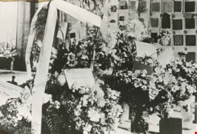
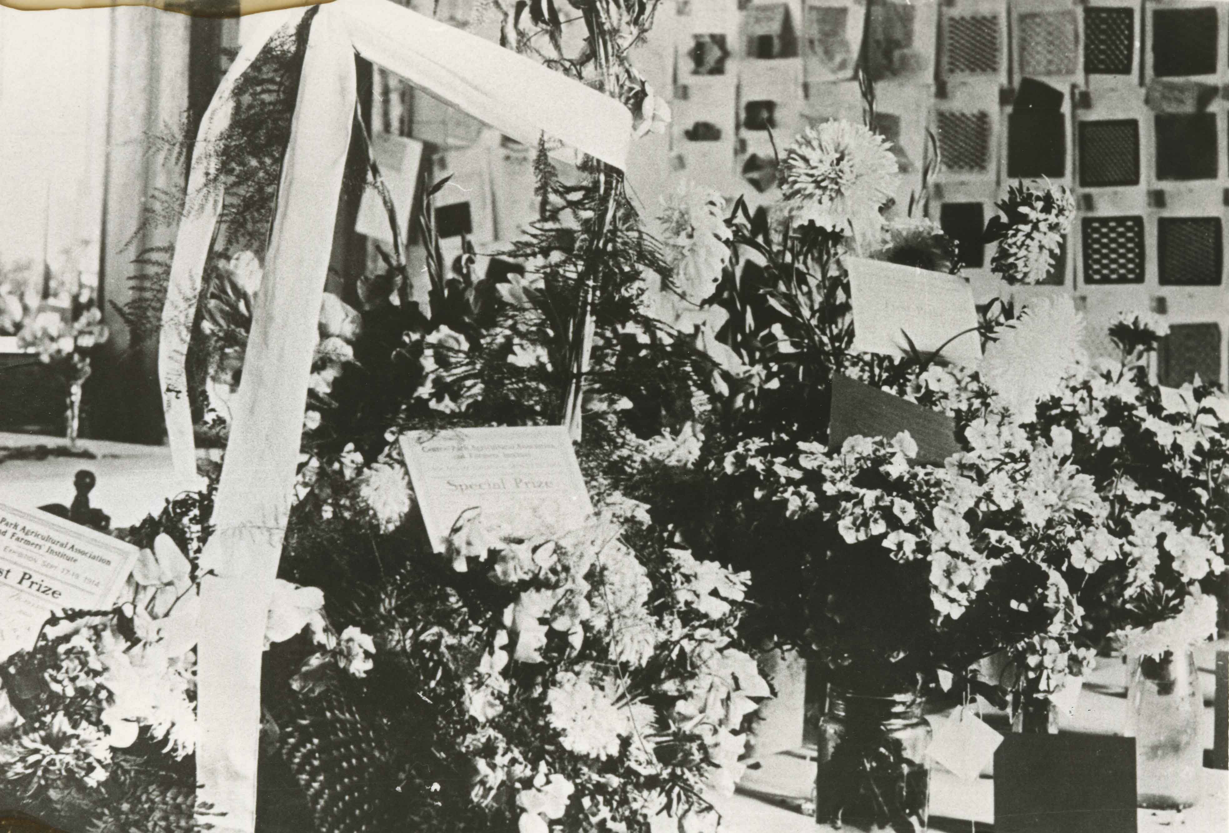
Central Park Agricultural Hall Fair
https://search.heritageburnaby.ca/link/archivedescription35875
- Repository
- City of Burnaby Archives
- Date
- 1914 (date of original), copied 1986
- Collection/Fonds
- Burnaby Historical Society fonds
- Description Level
- Item
- Physical Description
- 1 photograph : b&w ; 12.7 x 17.8 cm print
- Scope and Content
- Photograph of Central Park Agricultural Hall 1914 fall fair. Includes flowers awarded prizes from the Central Park Agricultural Association and Farmers' Institute, and school children's woven mats on the back wall. The Hall's location was 3883 Imperial Street.
- Repository
- City of Burnaby Archives
- Date
- 1914 (date of original), copied 1986
- Collection/Fonds
- Burnaby Historical Society fonds
- Subseries
- Pioneer Tales subseries
- Physical Description
- 1 photograph : b&w ; 12.7 x 17.8 cm print
- Description Level
- Item
- Record No.
- 204-734
- Access Restriction
- No restrictions
- Reproduction Restriction
- No known restrictions
- Accession Number
- BHS1988-03
- Scope and Content
- Photograph of Central Park Agricultural Hall 1914 fall fair. Includes flowers awarded prizes from the Central Park Agricultural Association and Farmers' Institute, and school children's woven mats on the back wall. The Hall's location was 3883 Imperial Street.
- Media Type
- Photograph
- Notes
- Title based on contents of photograph
- Geographic Access
- Central Park
- Imperial Street
- Street Address
- 3883 Imperial Street
- Historic Neighbourhood
- Central Park (Historic Neighbourhood)
- Planning Study Area
- Maywood Area
Images
![Chicken houses at Oakalla, [195-] (date of original), copied 1991 thumbnail](/media/hpo/_Data/_Archives_Images/_Unrestricted/370/370-717.jpg?width=280)
Chicken houses at Oakalla
https://search.heritageburnaby.ca/link/archivedescription38130
- Repository
- City of Burnaby Archives
- Date
- [195-] (date of original), copied 1991
- Collection/Fonds
- Burnaby Historical Society fonds
- Description Level
- Item
- Physical Description
- 1 photograph : b&w ; 3.0 x 4.3 cm print on contact sheet 19.8 x 26.2 cm
- Scope and Content
- Photograph of the exterior of chicken houses at Oakalla Prison Farm.
- Repository
- City of Burnaby Archives
- Date
- [195-] (date of original), copied 1991
- Collection/Fonds
- Burnaby Historical Society fonds
- Subseries
- Burnaby Image Bank subseries
- Physical Description
- 1 photograph : b&w ; 3.0 x 4.3 cm print on contact sheet 19.8 x 26.2 cm
- Description Level
- Item
- Record No.
- 370-717
- Access Restriction
- No restrictions
- Reproduction Restriction
- Reproduce for fair dealing purposes only
- Accession Number
- BHS1999-03
- Scope and Content
- Photograph of the exterior of chicken houses at Oakalla Prison Farm.
- Subjects
- Animals - Poultry
- Agriculture - Farms
- Names
- Oakalla Prison Farm
- Media Type
- Photograph
- Notes
- Title based on contents of photograph
- 1 b&w copy negative accompanying
- Negative has a pink cast
- Geographic Access
- Oakmount Crescent
- Street Address
- 5220 Oakmount Crescent
- Historic Neighbourhood
- Burnaby Lake (Historic Neighbourhood)
- Planning Study Area
- Oakalla Area
Images
![Chicken houses at Oakalla, [195-] (date of original), copied 1991 thumbnail](/media/hpo/_Data/_Archives_Images/_Unrestricted/370/370-717.jpg)
![Chickens at Meyers, [between 1950 and 1959] thumbnail](/media/hpo/_Data/_Archives_Images/_Unrestricted/600/620-010.jpg?width=280)
Chickens at Meyers
https://search.heritageburnaby.ca/link/archivedescription91829
- Repository
- City of Burnaby Archives
- Date
- [between 1950 and 1959]
- Collection/Fonds
- Small family fonds
- Description Level
- Item
- Physical Description
- 1 photograph : b&w ; 6.5 cm x 9 cm
- Scope and Content
- Photograph of chickens feeding at the Meyers' property at 5106 Douglas Road.
- Repository
- City of Burnaby Archives
- Date
- [between 1950 and 1959]
- Collection/Fonds
- Small family fonds
- Physical Description
- 1 photograph : b&w ; 6.5 cm x 9 cm
- Description Level
- Item
- Record No.
- 620-010
- Access Restriction
- No restrictions
- Reproduction Restriction
- No reproduction permitted
- Accession Number
- 2017-01
- Scope and Content
- Photograph of chickens feeding at the Meyers' property at 5106 Douglas Road.
- Subjects
- Agriculture - Poultry
- Media Type
- Photograph
- Notes
- Transcribed title
- Title transcribed from note on verso of photograph
- 5106 Douglas Road later subdivided into 5539 and 5545 Norfolk Street.
- Note in blue ink on verso of photograph reads: "Chickens at Meyers 1950's / (Ernest and Magdalena Meyers) Residence / 5106 Douglas Rd."
- Note in blue ink on verso of photograph reads: "P.10"
- Note in blue ink on verso of photograph (struck through) reads: "E.A. Meyers Residence ./ Photo by Pat Meyers / 1976?"
- Stamp in green ink on verso of photograph reads: "734J"
- Street Address
- 5106 Douglas Road
- Historic Neighbourhood
- Burnaby Lake (Historic Neighbourhood)
- Planning Study Area
- Ardingley-Sprott Area
Images
![Chickens at Meyers, [between 1950 and 1959] thumbnail](/media/hpo/_Data/_Archives_Images/_Unrestricted/600/620-010.jpg)
![Chinese man working in field, [191-] thumbnail](/media/hpo/_Data/_BVM_Images/2022/2022_0032_0175_001.jpg?width=280)
Chinese man working in field
https://search.heritageburnaby.ca/link/museumdescription19753
- Repository
- Burnaby Village Museum
- Date
- [191-]
- Collection/Fonds
- Esther Love Stanley fonds
- Description Level
- Item
- Physical Description
- 1 photograph : b&w ; 5.5 x 8 cm
- Scope and Content
- Photograph of an unidentified Chinese man crouched down and working in a field. A gardening hoe is leaning on his shoulder and there are young trees growing behind him. This field and orchard could be located on the Love family property.
- Repository
- Burnaby Village Museum
- Collection/Fonds
- Esther Love Stanley fonds
- Description Level
- Item
- Physical Description
- 1 photograph : b&w ; 5.5 x 8 cm
- Scope and Content
- Photograph of an unidentified Chinese man crouched down and working in a field. A gardening hoe is leaning on his shoulder and there are young trees growing behind him. This field and orchard could be located on the Love family property.
- Accession Code
- BV022.32.175
- Access Restriction
- No restrictions
- Reproduction Restriction
- No known restrictions
- Date
- [191-]
- Media Type
- Photograph
- Scan Resolution
- 600
- Scan Date
- 2023-04-04
- Notes
- Title based on contents of photograph
- Photograph is part of Esther Love Stanley photograph album 1 (BV022.32.1)
Images
![Chinese man working in field, [191-] thumbnail](/media/hpo/_Data/_BVM_Images/2022/2022_0032_0175_001.jpg)
City Council and Office of the City Clerk fonds
https://search.heritageburnaby.ca/link/archivedescription29
- Repository
- City of Burnaby Archives
- Date
- 1892-2021
- Collection/Fonds
- City Council and Office of the City Clerk fonds
- Description Level
- Fonds
- Physical Description
- 130m of textual records and other material
- Scope and Content
- Fonds consists of records generated in the course of municipal business by City Council and the Office of the City Clerk.
- Repository
- City of Burnaby Archives
- Date
- 1892-2021
- Collection/Fonds
- City Council and Office of the City Clerk fonds
- Physical Description
- 130m of textual records and other material
- Description Level
- Fonds
- Access Restriction
- Subject to FOIPPA
- Scope and Content
- Fonds consists of records generated in the course of municipal business by City Council and the Office of the City Clerk.
- History
- The City of Burnaby covers an area of approximately 98 square kilometers between the cities of Vancouver to the west, and Coquitlam and New Westminster to the east, Burrard Inlet to the north, and the Fraser River to the south. The municipality derived its name from Robert Burnaby, a prominent businessman and advisor to Sir James Douglas, the first Governor of the Crown Colony of British Columbia. Burnaby’s early development was closely tied to the development of the City of New Westminster. New Westminster became British Columbia’s capital in 1859, the year after the British Government proclaimed the establishment of British Columbia. Shortly thereafter, the Royal Engineers began exploring Burnaby to establish military defenses and secure natural resources. This involved the construction of a road linking New Westminster to Burrard Inlet for military purposes, which is present-day North Road. At this time, individuals and families began settling in Burnaby and were largely involved in agricultural and logging activities. Burnaby developed slowly until 1887, when the Canadian Pacific Railway was extended into Vancouver from the Port Moody terminal, causing a dramatic increase in traffic between New Westminster and Vancouver. To meet the new transportation demands, a tramline was built in 1891 connecting the two urban centers along what is now Kingsway. The creation and location of the tramline induced property owners to begin subdividing and selling their lands as early as October 1891. The property taxes the roughly 200 residents paid at this time went directly to the provincial government in Victoria. No local services were provided in turn, which prompted the formation of a committee to petition the provincial government for a municipal charter. As a result, the Corporation of the District of Burnaby was incorporated by letters patent on September 22, 1892. Burnaby’s first Council was elected by acclamation on October 15, 1892 and consisted of Reeve Charles R. Shaw and councillors William Brenchley, Arthur De Windt Hazard, L. Claude Hill, William McDermott, and John Woolard.* The first formal Council election was conducted three months later. Nicolai Shou became the first elected reeve of Burnaby by ballot. Council met at various locations, including the tramline’s power house, private homes, and offices until the first municipal hall was built at Kingsway and Edmonds in 1899. Council is ultimately responsible for the government of the City of Burnaby. The Mayor (formally called “Reeve” prior to 1968) and Council are elected by the residents of Burnaby to represent them in decisions with respect to the provision of public services and facilities. Additionally, the Mayor represents the citizens of Burnaby at various public functions and events. Burnaby was without Council representation during most of the Great Depression and part of the Second World War. Council was disbanded on December 31, 1932 as a result of financial difficulties. The Provincial Government appointed a Commissioner to take over the duties of Reeve and Council beginning in 1933. This system of government was retained until January 1943, when Burnaby residents could once again elect their local government officials. The following individuals have served as Mayor (or Reeve) of Burnaby: Charles R. Shaw 1892 Nicolai C. Schou 1893-1903 Charles F. Sprott 1904-1905 Peter Byrne 1906-1910 John W. Weart 1911-1912 Duncan C. McGregor 1913 Hugh M. Fraser 1914-1918 Thomas Sanderson 1919-1920 Alexander K. McLean 1921-1926; 1928-1929 Charles C. Bell 1927 William L. Burdick 1929 William A. Pritchard 1930-1932 William Tate Wilson 1943-1944 George A. Morrison 1945-1949 William R. Beamish 1950-1953 Charles W. MacSorley 1954-1957 Alan H. Emmott 1958-1968 Robert W. Prittie 1969-1973 Thomas W. Constable 1973-1979 David M. Mercier 1979-1981 William A. Lewarne 1981-1987 William J. Copeland 1987-1996 Douglas P. Drummond 1996-2002 Derek R. Corrigan 2002-2018 Mike Hurley 2018-present The following individuals have served as provincially appointed Commissioners for the Corporation of the District of Burnaby: John Bennett 1933 John Mahony 1933-1934 Hugh M. Fraser 1934-1940* R.S. Gilchrist 1941-1942* B.C. Bracewell 1942* *Richard Bolton was Acting Commissioner for most of 1940-1942. He refused to be a full-fledged Commissioner. Closely associated with the functions of Council is the City Clerk. The Office of the City Clerk is responsible for the statutory duties of the municipal clerk including the preparation and preservation of all minutes books and records of Council business, custody of City bylaws, administrative support to Council and its Committees, preparation of Council and Committee agendas and the conduct of local government elections. The Clerk’s Office is the communications link between Council and other City Departments and the general public, and provides assistance and advice to citizens with respect to Council and Council Committee processes, reporting procedures and decisions. At the time of Burnaby’s incorporation in 1892, the municipal Clerk had the responsibility to attend all meetings of Council, keep all records of Council, prepare and alter voters’ lists, conduct Council elections, collect revenue, as well as having the responsibility to prepare balance sheets and audits. An advertisement in a local newspaper for the appointment of the Clerk dated February 1, 1905 states the “united offices of clerk, collector and assessor” receive a salary of $65.00 per month. Originally the treasurer, assessor and records manager for the corporation, the Clerk eventually became the municipal Council liaison. The primary functions of the City Clerk over time have been the keeping of minutes for the meetings of City Council and related bodies; keeping the records of the City of Burnaby as required by the Local Government Act (formally Municipal Act); keeping all records related to City Council decision making; carrying out correspondence on behalf of Council; assembling voters’ lists and carrying out elections; providing communication, information, and public relations services, including responsibility for civic ceremonies/events, and the municipal archives. The following individuals have served as City Clerk: Alexander Philip 1892–1894 Alfred Smither 1894–1899 F.J.H. Shirley 1899–1901 Arthur De Windt Haszard 1901–1902 Walter J. Walker 1902–1905 Benjamin George Walker 1905–1908 Charles Thomas Saunders 1908–1911 W.M. Griffiths 1911–1912 Arthur G. Moore 1912–1933 Charles Boyer Brown 1933–1959 John H. Shaw 1959–1973* James Hudson 1974–1984 Charles A. Turpin 1984–1995 Debbie R. Comis 1995–2011 Anne Skipsey (Acting) 2011-2012 Maryann Manuel (Acting) 2012-2014 Dennis Back 2014-2018 Kate O'Connell 2018-2020 Blanka Zeinabova 2020-2022 *Deputy City Clerk T. Ward took over many of the Clerk’s duties from 1972 to 1973 due to Shaw’s ill health during these years.
- Formats
- Microforms exist for some records. See series descriptions.
- Media Type
- Textual Record
- Creator
- City of Burnaby
- Notes
- Title based on creators of fonds
![Claude Hill, [1915] thumbnail](/media/hpo/_Data/_Archives_Images/_Unrestricted/477/477-655.jpg?width=280)
Claude Hill
https://search.heritageburnaby.ca/link/archivedescription39336
- Repository
- City of Burnaby Archives
- Date
- [1915]
- Collection/Fonds
- Peers Family and Hill Family fonds
- Description Level
- Item
- Physical Description
- 1 photograph : b&w ; 5.9 x 10.4 cm on page 24.5 x 32.5 cm (pasted in album)
- Scope and Content
- Photograph of Claude Hill in his fields, standing next to a row of bushes and fence posts.
- Repository
- City of Burnaby Archives
- Date
- [1915]
- Collection/Fonds
- Peers Family and Hill Family fonds
- Physical Description
- 1 photograph : b&w ; 5.9 x 10.4 cm on page 24.5 x 32.5 cm (pasted in album)
- Description Level
- Item
- Record No.
- 477-655
- Access Restriction
- No restrictions
- Reproduction Restriction
- No known restrictions
- Accession Number
- 2007-12
- Scope and Content
- Photograph of Claude Hill in his fields, standing next to a row of bushes and fence posts.
- Subjects
- Agriculture - Farms
- Media Type
- Photograph
- Notes
- Title based on contents of photograph
- Historic Neighbourhood
- Burnaby Lake (Historic Neighbourhood)
- Planning Study Area
- Morley-Buckingham Area
Images
![Claude Hill, [1915] thumbnail](/media/hpo/_Data/_Archives_Images/_Unrestricted/477/477-655.jpg)

Coburn House
https://search.heritageburnaby.ca/link/landmark510
- Repository
- Burnaby Heritage Planning
- Description
- The Coburn House is a two and one-half storey plus basement Foursquare farm house. Prominently situated on a rise of land along the east side of Boundary Road overlooking Kingsway, it stands among single-family houses later constructed on its subdivided farm land.
- Associated Dates
- 1910
- Formal Recognition
- Heritage Designation, Community Heritage Register
- Other Names
- Minerva Jane Coburn House
- Street View URL
- Google Maps Street View
- Repository
- Burnaby Heritage Planning
- Other Names
- Minerva Jane Coburn House
- Geographic Access
- Boundary Road
- Associated Dates
- 1910
- Formal Recognition
- Heritage Designation, Community Heritage Register
- Enactment Type
- Bylaw No. 9184
- Enactment Date
- 08/05/1989
- Description
- The Coburn House is a two and one-half storey plus basement Foursquare farm house. Prominently situated on a rise of land along the east side of Boundary Road overlooking Kingsway, it stands among single-family houses later constructed on its subdivided farm land.
- Heritage Value
- The Coburn House is important as a surviving representation of Burnaby’s early settlement period, when the municipality was largely an agricultural and residential suburb. It was built in 1910 by carpenter William Kirkham for Minerva Jane Coburn (1868-1940), and three years later the builder and client were married. Together, they operated the Surprise Poultry Farm, and were frequent participants at the local Central Park Farmers' Institute Exhibitions. This house is valued as an excellent and well-preserved example of a substantial Edwardian era Foursquare farm house. Significant due to its generous size, dominant symmetry, the prominent verandah that wraps around the front and both sides, and the three roof dormers, this house retains a high degree of original material and integrity. The elevated siting of the house, its tall proportions and symmetrical appearance combined with its fine condition make this an excellent example of its type.
- Defining Elements
- Key elements that define the heritage character of the Coburn House include its: - prominent location on Boundary Road, on an elevated site overlooking Vancouver - residential form, scale and massing as expressed by its cubic massing and tall, dominant roof form - Foursquare style as exemplified by its symmetry, square floor plan, pyramidal bellcast roof and three hipped dormers - Edwardian era construction details such as narrow bevelled wooden siding, broad horizontal eave band with scroll-cut eave brackets, and simple window surrounds - wraparound verandah encircling three main facades, with hipped roof, square columns and closed balustrades, connected to one storey extension at rear - projecting bay window on the main floor south facade - original double-hung 1-over-1 wooden-sash windows, some in double assembly on the ground floor - internal red brick chimney
- Historic Neighbourhood
- Central Park (Historic Neighbourhood)
- Planning Study Area
- Garden Village Area
- Function
- Primary Historic--Single Dwelling
- Primary Current--Single Dwelling
- Community
- Burnaby
- Cadastral Identifier
- 002-653-427
- Boundaries
- The Coburn House is comprised of a single residential lot located at 5170 Boundary Road, Burnaby
- Area
- 541.91
- Contributing Resource
- Building
- Ownership
- Private
- Street Address
- 5170 Boundary Road
- Street View URL
- Google Maps Street View
Images


Constable Patrol in Neighbourhood of Central Park Agricultural Hall
https://search.heritageburnaby.ca/link/councilreport75230
- Repository
- City of Burnaby Archives
- Report ID
- 74722
- Meeting Date
- 29-May-1911
- Format
- Council - Committee Report
- Collection/Fonds
- City Council and Office of the City Clerk fonds
- Repository
- City of Burnaby Archives
- Report ID
- 74722
- Meeting Date
- 29-May-1911
- Format
- Council - Committee Report
- Collection/Fonds
- City Council and Office of the City Clerk fonds
Documents
![Dairy and Silos at Oakalla, [195-] (date of original), copied 1991 thumbnail](/media/hpo/_Data/_Archives_Images/_Unrestricted/370/370-716.jpg?width=280)
Dairy and Silos at Oakalla
https://search.heritageburnaby.ca/link/archivedescription38129
- Repository
- City of Burnaby Archives
- Date
- [195-] (date of original), copied 1991
- Collection/Fonds
- Burnaby Historical Society fonds
- Description Level
- Item
- Physical Description
- 1 photograph : b&w ; 3.0 x 4.3 cm print on contact sheet 19.8 x 26.2 cm
- Scope and Content
- Photograph of the exterior of the dairy and silos at Oakalla Prison Farm.
- Repository
- City of Burnaby Archives
- Date
- [195-] (date of original), copied 1991
- Collection/Fonds
- Burnaby Historical Society fonds
- Subseries
- Burnaby Image Bank subseries
- Physical Description
- 1 photograph : b&w ; 3.0 x 4.3 cm print on contact sheet 19.8 x 26.2 cm
- Description Level
- Item
- Record No.
- 370-716
- Access Restriction
- No restrictions
- Reproduction Restriction
- Reproduce for fair dealing purposes only
- Accession Number
- BHS1999-03
- Scope and Content
- Photograph of the exterior of the dairy and silos at Oakalla Prison Farm.
- Names
- Oakalla Prison Farm
- Media Type
- Photograph
- Notes
- Title based on contents of photograph
- 1 b&w copy negative accompanying
- Negative has a pink cast
- Geographic Access
- Oakmount Crescent
- Street Address
- 5220 Oakmount Crescent
- Historic Neighbourhood
- Burnaby Lake (Historic Neighbourhood)
- Planning Study Area
- Oakalla Area
Images
![Dairy and Silos at Oakalla, [195-] (date of original), copied 1991 thumbnail](/media/hpo/_Data/_Archives_Images/_Unrestricted/370/370-716.jpg)

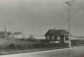
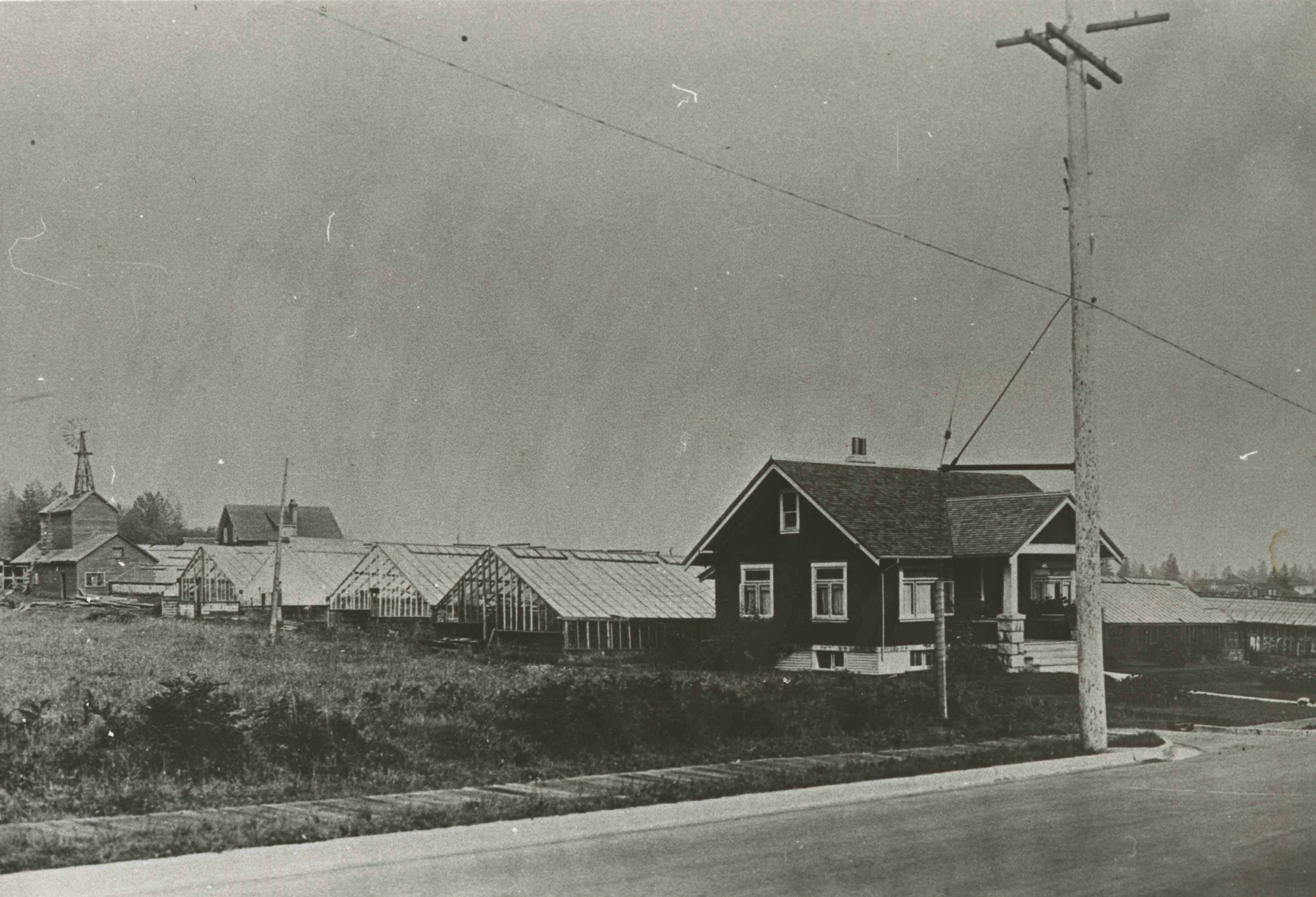
Davies and Sons Nursery
https://search.heritageburnaby.ca/link/archivedescription34545
- Repository
- City of Burnaby Archives
- Date
- 1914
- Collection/Fonds
- Burnaby Historical Society fonds
- Description Level
- Item
- Physical Description
- 1 photograph : b&w ; 16.0 x 21.1 cm mounted on 19.1x 24.3 cm cardboard
- Scope and Content
- Photograph of Davies & Sons nursery, 1349 Kingsway (later renumbered 7670 Kingsway), below Edmonds Street. Greenhouses, a board sidewalk, the road, and a windmill can be seen.
- Repository
- City of Burnaby Archives
- Date
- 1914
- Collection/Fonds
- Burnaby Historical Society fonds
- Subseries
- Photographs subseries
- Physical Description
- 1 photograph : b&w ; 16.0 x 21.1 cm mounted on 19.1x 24.3 cm cardboard
- Description Level
- Item
- Record No.
- 044-005
- Access Restriction
- No restrictions
- Reproduction Restriction
- No known restrictions
- Accession Number
- BHS2007-04
- Scope and Content
- Photograph of Davies & Sons nursery, 1349 Kingsway (later renumbered 7670 Kingsway), below Edmonds Street. Greenhouses, a board sidewalk, the road, and a windmill can be seen.
- Subjects
- Buildings - Agricultural - Nurseries
- Names
- Davies and Sons Nursery
- Media Type
- Photograph
- Notes
- Title based on contents of photograph
- Geographic Access
- Kingsway
- Street Address
- 7670 Kingsway
- Historic Neighbourhood
- Edmonds (Historic Neighbourhood)
- Planning Study Area
- Edmonds Area
Images
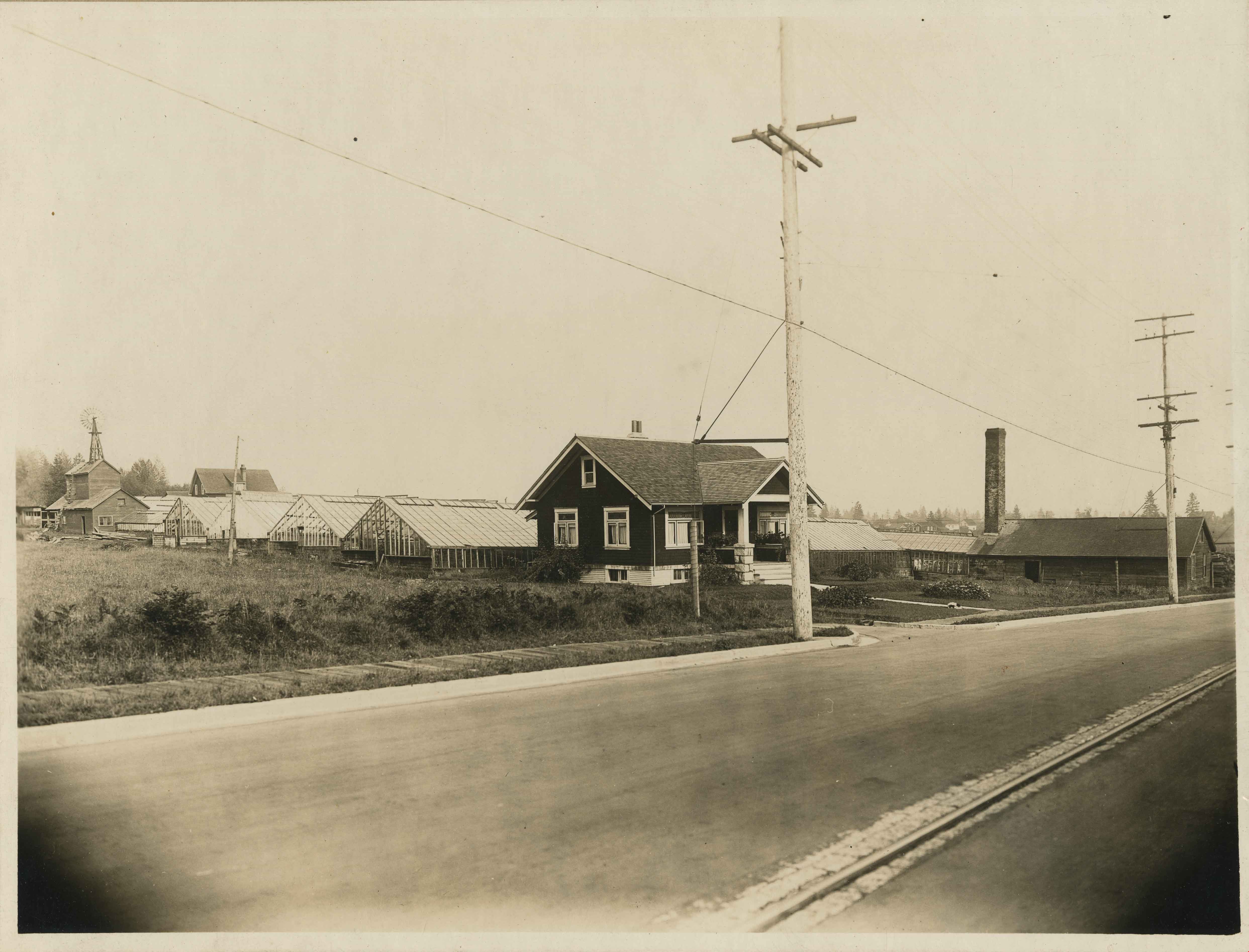
Davies and Sons Nursery
https://search.heritageburnaby.ca/link/archivedescription35872
- Repository
- City of Burnaby Archives
- Date
- 1919 (date of original), copied 1986
- Collection/Fonds
- Burnaby Historical Society fonds
- Description Level
- Item
- Physical Description
- 1 photograph : b&w ; 12.7 x 17.8 cm print
- Scope and Content
- Photograph of Davies & Sons nursery, 1349 Kingsway (later renumbered 7670 Kingsway).
- Repository
- City of Burnaby Archives
- Date
- 1919 (date of original), copied 1986
- Collection/Fonds
- Burnaby Historical Society fonds
- Subseries
- Pioneer Tales subseries
- Physical Description
- 1 photograph : b&w ; 12.7 x 17.8 cm print
- Description Level
- Item
- Record No.
- 204-731
- Access Restriction
- No restrictions
- Reproduction Restriction
- No known restrictions
- Accession Number
- BHS1988-03
- Scope and Content
- Photograph of Davies & Sons nursery, 1349 Kingsway (later renumbered 7670 Kingsway).
- Names
- Davies and Sons Nursery
- Media Type
- Photograph
- Notes
- Title based on contents of photograph
- Geographic Access
- Kingsway
- Street Address
- 7670 Kingsway
- Historic Neighbourhood
- Edmonds (Historic Neighbourhood)
- Planning Study Area
- Edmonds Area
Images
Davis-Watkins dairy equipment and supplies for those who want good machinery and good service at a reasonable price
https://search.heritageburnaby.ca/link/museumlibrary2263
- Repository
- Burnaby Village Museum
- Collection
- Special Collection
- Material Type
- Book
- Accession Code
- HV977.29.50
- Call Number
- 637 DAV
- Place of Publication
- Chicago
- Publisher
- Davis-Watkins Dairymen's Mfg. Co.
- Publication Date
- 1919
- Physical Description
- 1 v. (multiple pagings) : ill. : 29 cm.
- Subjects
- Agriculture
- Agriculture - Dairy
![Deer Lake Drive, [1918] thumbnail](/media/hpo/_Data/_BVM_Images/1972/1972_0051_0012_001.jpg?width=280)
Deer Lake Drive
https://search.heritageburnaby.ca/link/museumdescription1085
- Repository
- Burnaby Village Museum
- Date
- [1918]
- Collection/Fonds
- Burnaby Village Museum Photograph collection
- Description Level
- Item
- Physical Description
- 1 photograph : b&w ; 12.9 x 32.9 cm
- Scope and Content
- Photograph is a panorama of Deer Lake Drive, including the Ceperley mansion and the surrounding grounds of the home to the left of the picture. The photograph, taken from the water tower, with Burnaby Lake in the background. In the midground, following the horizon line, power poles can be seen. Far…
- Repository
- Burnaby Village Museum
- Collection/Fonds
- Burnaby Village Museum Photograph collection
- Description Level
- Item
- Physical Description
- 1 photograph : b&w ; 12.9 x 32.9 cm
- Scope and Content
- Photograph is a panorama of Deer Lake Drive, including the Ceperley mansion and the surrounding grounds of the home to the left of the picture. The photograph, taken from the water tower, with Burnaby Lake in the background. In the midground, following the horizon line, power poles can be seen. Farm lands are visible leading down to the homes of the Andersons. An annotation on the back of the photo in pencil reads, "Deer Lake Dr." and an annotation in blue pen reads, "1918."
- Geographic Access
- Deer Lake Drive
- Deer Lake Avenue
- Street Address
- 6344 Deer Lake Avenue
- Accession Code
- HV972.51.12
- Access Restriction
- No restrictions
- Reproduction Restriction
- No known restrictions
- Date
- [1918]
- Media Type
- Photograph
- Historic Neighbourhood
- Burnaby Lake (Historic Neighbourhood)
- Planning Study Area
- Douglas-Gilpin Area
- Scan Resolution
- 600
- Scan Date
- 2023-04-04
Images
![Deer Lake Drive, [1918] thumbnail](/media/hpo/_Data/_BVM_Images/1972/1972_0051_0012_001.jpg)