Narrow Results By
Subject
- Advertising Medium - Signs and Signboards 4
- Aerial Photographs 1
- Agricultural Tools and Equipment 29
- Agricultural Tools and Equipment - Cultivators 3
- Agricultural Tools and Equipment - Gardening Equipment 13
- Agricultural Tools and Equipment - Plows 9
- Agricultural Tools and Equipment - Tractors 1
- Agriculture 47
- Agriculture - Beekeeping 3
- Agriculture - Crops 39
- Agriculture - Dairy 7
- Agriculture - Farms 208
Creator
- Association for Living Historical Farms and Agricultural Museums, U.S.A. 1
- Association for Living History, Farm and Agricultural Museums 5
- Ballantyne, James 1
- Bancroft, Rose 1
- Bartel, Mario 7
- Beatty Bros Limited 1
- Bellinger, Bernard 1
- Born, A. J. 2
- Brittain, John, 1849-1913 1
- Bullen, Harry Elder 1
- Burch, D. S. (Dallas Stockwell), 1886- 1
- Burnaby Community Heritage Commission 1
Lubbock farmhouse
https://search.heritageburnaby.ca/link/museumdescription12758
- Repository
- Burnaby Village Museum
- Date
- 1977
- Collection/Fonds
- Century Park Museum Association fonds
- Description Level
- Item
- Physical Description
- 1 photograph : col. slide ; 35 mm
- Scope and Content
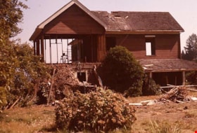
- Photograph of the Lubbock farmhouse located at 7803 Burris Street near Burnaby Lake. The windows and some walls are missing and there is a hole in the roof.
- Repository
- Burnaby Village Museum
- Collection/Fonds
- Century Park Museum Association fonds
- Description Level
- Item
- Physical Description
- 1 photograph : col. slide ; 35 mm
- Scope and Content
- Photograph of the Lubbock farmhouse located at 7803 Burris Street near Burnaby Lake. The windows and some walls are missing and there is a hole in the roof.
- History
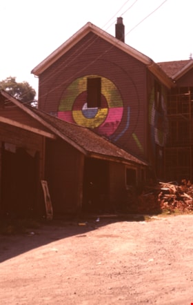
- In 1977, Century Park Museum was granted access to the Sprott-Lubbock farm to appraise the heritage buildings for preservation. Buildings that were saved included the old farrier shed (BV985.1240.2) which was also used as a blacksmith shop and the Vorce tram station building (BV985.1240.3) from the old Burnaby Lake Interurban line which was used as a grain storage shed on the property. Segments of the original farmhouse and other out buildings were retained. Other buildings on the site were demolished to make way for a new housing development.
- Subjects
- Agriculture - Farms
- Names
- Lubbock farm
- Geographic Access
- Grandview Highway
- Burris Street
- Street Address
- 7803 Burris Street
- Accession Code
- BV020.5.435
- Access Restriction
- No restrictions
- Reproduction Restriction
- No known restrictions
- Date
- 1977
- Media Type
- Photograph
- Historic Neighbourhood
- Burnaby Lake (Historic Neighbourhood)
- Planning Study Area
- Morley-Buckingham Area
- Scan Resolution
- 2400
- Scan Date
- 13-Mar-20
- Scale
- 100
- Notes
- Title based on contents of photograph
Images

Lubbock farmhouse
https://search.heritageburnaby.ca/link/museumdescription12759
- Repository
- Burnaby Village Museum
- Date
- 1977
- Collection/Fonds
- Century Park Museum Association fonds
- Description Level
- Item
- Physical Description
- 1 photograph : col. slide ; 35 mm
- Scope and Content
- Photograph of the Lubbock farmhouse located at 7803 Burris Street near Burnaby Lake. The windows and some walls are missing and there is a hole in the roof.
- Repository
- Burnaby Village Museum
- Collection/Fonds
- Century Park Museum Association fonds
- Description Level
- Item
- Physical Description
- 1 photograph : col. slide ; 35 mm
- Scope and Content
- Photograph of the Lubbock farmhouse located at 7803 Burris Street near Burnaby Lake. The windows and some walls are missing and there is a hole in the roof.
- History
- In 1977, Century Park Museum was granted access to the Sprott-Lubbock farm to appraise the heritage buildings for preservation. Buildings that were saved included the old farrier shed (BV985.1240.2) which was also used as a blacksmith shop and the Vorce tram station building (BV985.1240.3) from the old Burnaby Lake Interurban line which was used as a grain storage shed on the property. Segments of the original farmhouse and other out buildings were retained. Other buildings on the site were demolished to make way for a new housing development.
- Subjects
- Agriculture - Farms
- Names
- Lubbock farm
- Geographic Access
- Grandview Highway
- Burris Street
- Street Address
- 7803 Burris Street
- Accession Code
- BV020.5.436
- Access Restriction
- No restrictions
- Reproduction Restriction
- No known restrictions
- Date
- 1977
- Media Type
- Photograph
- Historic Neighbourhood
- Burnaby Lake (Historic Neighbourhood)
- Planning Study Area
- Morley-Buckingham Area
- Scan Resolution
- 2400
- Scan Date
- 13-Mar-20
- Scale
- 100
- Notes
- Title based on contents of photograph
Images

Lubbock farmhouse
https://search.heritageburnaby.ca/link/museumdescription12770
- Repository
- Burnaby Village Museum
- Date
- 1977
- Collection/Fonds
- Century Park Museum Association fonds
- Description Level
- Item
- Physical Description
- 1 photograph : col. slide ; 35 mm
- Scope and Content
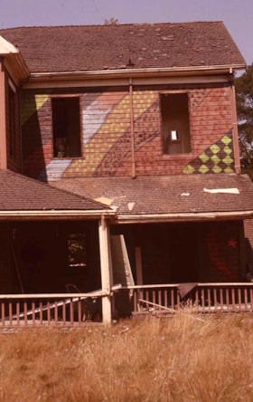
- Photograph of the Lubbock farmhouse. The house and farm were located at 7803 Burris Street near Burnaby Lake. A colour mural has been painted on the side of the house.
- Repository
- Burnaby Village Museum
- Collection/Fonds
- Century Park Museum Association fonds
- Description Level
- Item
- Physical Description
- 1 photograph : col. slide ; 35 mm
- Scope and Content
- Photograph of the Lubbock farmhouse. The house and farm were located at 7803 Burris Street near Burnaby Lake. A colour mural has been painted on the side of the house.
- History
- In 1977, Century Park Museum was granted access to the Sprott-Lubbock farm to appraise the heritage buildings for preservation. Buildings that were saved included the old farrier shed (BV985.1240.2) which was also used as a blacksmith shop and the Vorce tram station building (BV985.1240.3) from the old Burnaby Lake Interurban line which was used as a grain storage shed on the property. Segments of the original farmhouse and other out buildings were retained. Other buildings on the site were demolished to make way for a new housing development.
- Subjects
- Agriculture - Farms
- Names
- Lubbock farm
- Geographic Access
- Grandview Highway
- Burris Street
- Street Address
- 7803 Burris Street
- Accession Code
- BV020.5.447
- Access Restriction
- No restrictions
- Reproduction Restriction
- No known restrictions
- Date
- 1977
- Media Type
- Photograph
- Historic Neighbourhood
- Burnaby Lake (Historic Neighbourhood)
- Planning Study Area
- Morley-Buckingham Area
- Scan Resolution
- 2400
- Scan Date
- 13-Mar-20
- Scale
- 100
- Notes
- Title based on contents of photograph
Images

Lubbock farmhouse
https://search.heritageburnaby.ca/link/museumdescription12775
- Repository
- Burnaby Village Museum
- Date
- 1977
- Collection/Fonds
- Century Park Museum Association fonds
- Description Level
- Item
- Physical Description
- 1 photograph : col. slide ; 35 mm
- Scope and Content
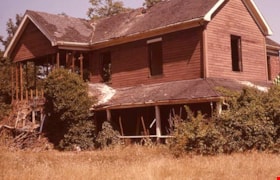
- Photograph of the Lubbock farmhouse that was located at 7803 Burris Street near Burnaby Lake. Tall grass and wildflowers are visible in the foreground.
- Repository
- Burnaby Village Museum
- Collection/Fonds
- Century Park Museum Association fonds
- Description Level
- Item
- Physical Description
- 1 photograph : col. slide ; 35 mm
- Scope and Content
- Photograph of the Lubbock farmhouse that was located at 7803 Burris Street near Burnaby Lake. Tall grass and wildflowers are visible in the foreground.
- History
- In 1977, Century Park Museum was granted access to the Sprott-Lubbock farm to appraise the heritage buildings for preservation. Buildings that were saved included the old farrier shed (BV985.1240.2) which was also used as a blacksmith shop and the Vorce tram station building (BV985.1240.3) from the old Burnaby Lake Interurban line which was used as a grain storage shed on the property. Segments of the original farmhouse and other out buildings were retained. Other buildings on the site were demolished to make way for a new housing development.
- Subjects
- Agriculture - Farms
- Names
- Lubbock farm
- Geographic Access
- Grandview Highway
- Burris Street
- Street Address
- 7803 Burris Street
- Accession Code
- BV020.5.452
- Access Restriction
- No restrictions
- Reproduction Restriction
- No known restrictions
- Date
- 1977
- Media Type
- Photograph
- Historic Neighbourhood
- Burnaby Lake (Historic Neighbourhood)
- Planning Study Area
- Morley-Buckingham Area
- Scan Resolution
- 2400
- Scan Date
- 13-Mar-20
- Scale
- 100
- Notes
- Title based on contents of photograph
Images


Lubbock farmhouse
https://search.heritageburnaby.ca/link/museumdescription12782
- Repository
- Burnaby Village Museum
- Date
- 1977
- Collection/Fonds
- Century Park Museum Association fonds
- Description Level
- Item
- Physical Description
- 1 photograph : col. slide ; 35 mm
- Scope and Content
- Photograph of the Lubbock farmhouse that was located at 7803 Burris Street near Burnaby Lake. Tall grass and wildflowers are visible in the foreground.
- Repository
- Burnaby Village Museum
- Collection/Fonds
- Century Park Museum Association fonds
- Description Level
- Item
- Physical Description
- 1 photograph : col. slide ; 35 mm
- Scope and Content
- Photograph of the Lubbock farmhouse that was located at 7803 Burris Street near Burnaby Lake. Tall grass and wildflowers are visible in the foreground.
- History
- In 1977, Century Park Museum was granted access to the Sprott-Lubbock farm to appraise the heritage buildings for preservation. Buildings that were saved included the old farrier shed (BV985.1240.2) which was also used as a blacksmith shop and the Vorce tram station building (BV985.1240.3) from the old Burnaby Lake Interurban line which was used as a grain storage shed on the property. Segments of the original farmhouse and other out buildings were retained. Other buildings on the site were demolished to make way for a new housing development.
- Subjects
- Agriculture - Farms
- Names
- Lubbock farm
- Geographic Access
- Grandview Highway
- Burris Street
- Street Address
- 7803 Burris Street
- Accession Code
- BV020.5.459
- Access Restriction
- No restrictions
- Reproduction Restriction
- No known restrictions
- Date
- 1977
- Media Type
- Photograph
- Historic Neighbourhood
- Burnaby Lake (Historic Neighbourhood)
- Planning Study Area
- Morley-Buckingham Area
- Scan Resolution
- 2400
- Scan Date
- 13-Mar-20
- Scale
- 100
- Notes
- Title based on contents of photograph
Images
Lubbock farmhouse
https://search.heritageburnaby.ca/link/museumdescription12785
- Repository
- Burnaby Village Museum
- Date
- 1977
- Collection/Fonds
- Century Park Museum Association fonds
- Description Level
- Item
- Physical Description
- 1 photograph : col. slide ; 35 mm
- Scope and Content
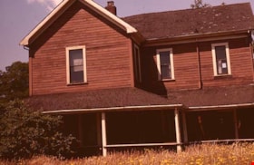
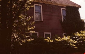
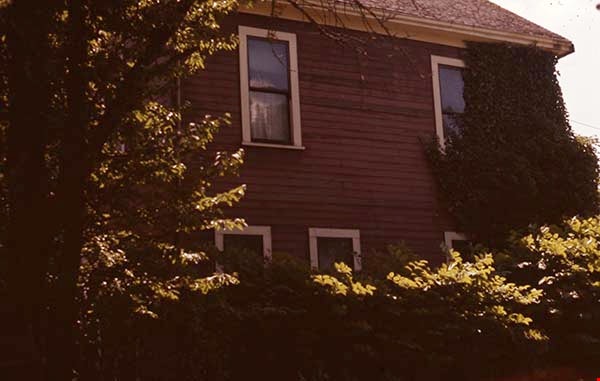
- Photograph of the Lubbock farmhouse that was located at 7803 Burris Street near Burnaby Lake. Trees and bushes surround the walls of the house.
- Repository
- Burnaby Village Museum
- Collection/Fonds
- Century Park Museum Association fonds
- Description Level
- Item
- Physical Description
- 1 photograph : col. slide ; 35 mm
- Scope and Content
- Photograph of the Lubbock farmhouse that was located at 7803 Burris Street near Burnaby Lake. Trees and bushes surround the walls of the house.
- History
- In 1977, Century Park Museum was granted access to the Sprott-Lubbock farm to appraise the heritage buildings for preservation. Buildings that were saved included the old farrier shed (BV985.1240.2) which was also used as a blacksmith shop and the Vorce tram station building (BV985.1240.3) from the old Burnaby Lake Interurban line which was used as a grain storage shed on the property. Segments of the original farmhouse and other out buildings were retained. Other buildings on the site were demolished to make way for a new housing development.
- Subjects
- Agriculture - Farms
- Names
- Lubbock farm
- Geographic Access
- Grandview Highway
- Burris Street
- Street Address
- 7803 Burris Street
- Accession Code
- BV020.5.462
- Access Restriction
- No restrictions
- Reproduction Restriction
- No known restrictions
- Date
- 1977
- Media Type
- Photograph
- Historic Neighbourhood
- Burnaby Lake (Historic Neighbourhood)
- Planning Study Area
- Morley-Buckingham Area
- Scan Resolution
- 2400
- Scan Date
- 13-Mar-20
- Scale
- 100
- Notes
- Title based on contents of photograph
Images
Lubbock farmhouse
https://search.heritageburnaby.ca/link/museumdescription12794
- Repository
- Burnaby Village Museum
- Date
- 1977
- Collection/Fonds
- Century Park Museum Association fonds
- Description Level
- Item
- Physical Description
- 1 photograph : col. slide ; 35 mm
- Scope and Content
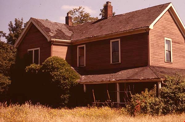
- Photograph of the Lubbock farmhouse located at 7803 Burris Street near Burnaby Lake.
- Repository
- Burnaby Village Museum
- Collection/Fonds
- Century Park Museum Association fonds
- Description Level
- Item
- Physical Description
- 1 photograph : col. slide ; 35 mm
- Scope and Content
- Photograph of the Lubbock farmhouse located at 7803 Burris Street near Burnaby Lake.
- History
- In 1977, Century Park Museum was granted access to the Sprott-Lubbock farm to appraise the heritage buildings for preservation. Buildings that were saved included the old farrier shed (BV985.1240.2) which was also used as a blacksmith shop and the Vorce tram station building (BV985.1240.3) from the old Burnaby Lake Interurban line which was used as a grain storage shed on the property. Segments of the original farmhouse and other out buildings were retained. Other buildings on the site were demolished to make way for a new housing development.
- Subjects
- Agriculture - Farms
- Names
- Lubbock farm
- Geographic Access
- Grandview Highway
- Burris Street
- Street Address
- 7803 Burris Street
- Accession Code
- BV020.5.471
- Access Restriction
- No restrictions
- Reproduction Restriction
- No known restrictions
- Date
- 1977
- Media Type
- Photograph
- Historic Neighbourhood
- Burnaby Lake (Historic Neighbourhood)
- Planning Study Area
- Morley-Buckingham Area
- Scan Resolution
- 2400
- Scan Date
- 13-Mar-20
- Scale
- 100
- Notes
- Title based on contents of photograph
Images

Lubbock farmhouse and shed
https://search.heritageburnaby.ca/link/museumdescription12767
- Repository
- Burnaby Village Museum
- Date
- 1977
- Collection/Fonds
- Century Park Museum Association fonds
- Description Level
- Item
- Physical Description
- 1 photograph : col. slide ; 35 mm
- Scope and Content
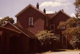
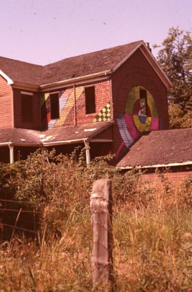
- Photograph of the Lubbock farmhouse and shed. The house and farm were located at 7803 Burris Street near Burnaby Lake. A colour mural has been painted on the side of the house.
- Repository
- Burnaby Village Museum
- Collection/Fonds
- Century Park Museum Association fonds
- Description Level
- Item
- Physical Description
- 1 photograph : col. slide ; 35 mm
- Scope and Content
- Photograph of the Lubbock farmhouse and shed. The house and farm were located at 7803 Burris Street near Burnaby Lake. A colour mural has been painted on the side of the house.
- History
- In 1977, Century Park Museum was granted access to the Sprott-Lubbock farm to appraise the heritage buildings for preservation. Buildings that were saved included the old farrier shed (BV985.1240.2) which was also used as a blacksmith shop and the Vorce tram station building (BV985.1240.3) from the old Burnaby Lake Interurban line which was used as a grain storage shed on the property. Segments of the original farmhouse and other out buildings were retained. Other buildings on the site were demolished to make way for a new housing development.
- Subjects
- Agriculture - Farms
- Names
- Lubbock farm
- Geographic Access
- Grandview Highway
- Burris Street
- Street Address
- 7803 Burris Street
- Accession Code
- BV020.5.444
- Access Restriction
- No restrictions
- Reproduction Restriction
- No known restrictions
- Date
- 1977
- Media Type
- Photograph
- Historic Neighbourhood
- Burnaby Lake (Historic Neighbourhood)
- Planning Study Area
- Morley-Buckingham Area
- Scan Resolution
- 2400
- Scan Date
- 13-Mar-20
- Scale
- 100
- Notes
- Title based on contents of photograph
Images

Lubbock farmhouse and shed
https://search.heritageburnaby.ca/link/museumdescription12769
- Repository
- Burnaby Village Museum
- Date
- 1977
- Collection/Fonds
- Century Park Museum Association fonds
- Description Level
- Item
- Physical Description
- 1 photograph : col. slide ; 35 mm
- Scope and Content
- Photograph of the Lubbock farmhouse and shed. The house and farm were located at 7803 Burris Street near Burnaby Lake. A colour mural has been painted on the side of the house.
- Repository
- Burnaby Village Museum
- Collection/Fonds
- Century Park Museum Association fonds
- Description Level
- Item
- Physical Description
- 1 photograph : col. slide ; 35 mm
- Scope and Content
- Photograph of the Lubbock farmhouse and shed. The house and farm were located at 7803 Burris Street near Burnaby Lake. A colour mural has been painted on the side of the house.
- History
- In 1977, Century Park Museum was granted access to the Sprott-Lubbock farm to appraise the heritage buildings for preservation. Buildings that were saved included the old farrier shed (BV985.1240.2) which was also used as a blacksmith shop and the Vorce tram station building (BV985.1240.3) from the old Burnaby Lake Interurban line which was used as a grain storage shed on the property. Segments of the original farmhouse and other out buildings were retained. Other buildings on the site were demolished to make way for a new housing development.
- Subjects
- Agriculture - Farms
- Names
- Lubbock farm
- Geographic Access
- Grandview Highway
- Burris Street
- Street Address
- 7803 Burris Street
- Accession Code
- BV020.5.446
- Access Restriction
- No restrictions
- Reproduction Restriction
- No known restrictions
- Date
- 1977
- Media Type
- Photograph
- Historic Neighbourhood
- Burnaby Lake (Historic Neighbourhood)
- Planning Study Area
- Morley-Buckingham Area
- Scan Resolution
- 2400
- Scan Date
- 13-Mar-20
- Scale
- 100
- Notes
- Title based on contents of photograph
Images

Lubbock farm shed
https://search.heritageburnaby.ca/link/museumdescription12780
- Repository
- Burnaby Village Museum
- Date
- 1977
- Collection/Fonds
- Century Park Museum Association fonds
- Description Level
- Item
- Physical Description
- 1 photograph : col. slide ; 35 mm
- Scope and Content
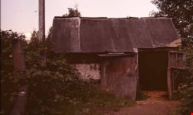
- Photograph of a small farm shed on the property of the Lubbock farm located at 7803 Burris Street near Burnaby Lake.
- Repository
- Burnaby Village Museum
- Collection/Fonds
- Century Park Museum Association fonds
- Description Level
- Item
- Physical Description
- 1 photograph : col. slide ; 35 mm
- Scope and Content
- Photograph of a small farm shed on the property of the Lubbock farm located at 7803 Burris Street near Burnaby Lake.
- History
- In 1977, Century Park Museum was granted access to the Sprott-Lubbock farm to appraise the heritage buildings for preservation. Buildings that were saved included the old farrier shed (BV985.1240.2) which was also used as a blacksmith shop and the Vorce tram station building (BV985.1240.3) from the old Burnaby Lake Interurban line which was used as a grain storage shed on the property. Segments of the original farmhouse and other out buildings were retained. Other buildings on the site were demolished to make way for a new housing development.
- Subjects
- Agriculture - Farms
- Names
- Lubbock farm
- Geographic Access
- Grandview Highway
- Burris Street
- Street Address
- 7803 Burris Street
- Accession Code
- BV020.5.457
- Access Restriction
- No restrictions
- Reproduction Restriction
- No known restrictions
- Date
- 1977
- Media Type
- Photograph
- Historic Neighbourhood
- Burnaby Lake (Historic Neighbourhood)
- Planning Study Area
- Morley-Buckingham Area
- Scan Resolution
- 2400
- Scan Date
- 13-Mar-20
- Scale
- 100
- Notes
- Title based on contents of photograph
Images

Lubbock photographs from album
https://search.heritageburnaby.ca/link/archivedescription64493
- Repository
- City of Burnaby Archives
- Date
- 1945-1988
- Collection/Fonds
- Burnaby Historical Society fonds
- Description Level
- File
- Physical Description
- 130 photographs : b&w and col. ; 20.5 x 25.5 cm or smaller
- Scope and Content
- Photographs of the Lubbock family, including their riding stables and horses, family events, their pets, and landscape and travel photographs. These photographs were originally housed in a photographic album.
- Repository
- City of Burnaby Archives
- Date
- 1945-1988
- Collection/Fonds
- Burnaby Historical Society fonds
- Subseries
- Lubbock family subseries
- Physical Description
- 130 photographs : b&w and col. ; 20.5 x 25.5 cm or smaller
- Description Level
- File
- Record No.
- 342-046
- Access Restriction
- In Archives only
- Reproduction Restriction
- May be restricted by third party rights
- Accession Number
- BHS1994-02
- Scope and Content
- Photographs of the Lubbock family, including their riding stables and horses, family events, their pets, and landscape and travel photographs. These photographs were originally housed in a photographic album.
- Names
- Lubbock, Ainsly
- Lubbock, Beatrice "Bea"
- Lubbock, Elizabeth
- Lubbock, Gordon
- Lubbock, John
- Lubbock, John Barker
- Lubbock, Mina
- Media Type
- Photograph
- Notes
- Title based on contents of photograph
- Geographic Access
- Grandview Highway
- Canada Way
- Burris Street
- Street Address
- 7803 Burris Street
- Historic Neighbourhood
- Burnaby Lake (Historic Neighbourhood)
- Planning Study Area
- Morley-Buckingham Area

Lubbock's farm
https://search.heritageburnaby.ca/link/archivedescription36517
- Repository
- City of Burnaby Archives
- Date
- 1977
- Collection/Fonds
- Burnaby Historical Society fonds
- Description Level
- Item
- Physical Description
- 1 photograph : col. ; 9 x 8.5 cm
- Scope and Content
- Copyright holder and creator are unknown. Copyright expires in 2053.
- Repository
- City of Burnaby Archives
- Date
- 1977
- Collection/Fonds
- Burnaby Historical Society fonds
- Subseries
- Lubbock family subseries
- Physical Description
- 1 photograph : col. ; 9 x 8.5 cm
- Description Level
- Item
- Record No.
- 289-006
- Access Restriction
- No restrictions
- Reproduction Restriction
- Reproduce for fair dealing purposes only
- Accession Number
- BHS1992-24
- Scope and Content
- Copyright holder and creator are unknown. Copyright expires in 2053.
- Media Type
- Photograph
- Notes
- Title based on contents of photograph
- Geographic Access
- Grandview Highway
- Canada Way
- Burris Street
- Street Address
- 7803 Burris Street
- Historic Neighbourhood
- Burnaby Lake (Historic Neighbourhood)
- Planning Study Area
- Morley-Buckingham Area
Images


Lubbock's stable and farm house
https://search.heritageburnaby.ca/link/archivedescription36512
- Repository
- City of Burnaby Archives
- Date
- 1977
- Collection/Fonds
- Burnaby Historical Society fonds
- Description Level
- Item
- Physical Description
- 1 photograph : col. ; 9 x 8.5 cm
- Scope and Content
- Photograph of Lubbock's farm taken from Canada Way at Haszard Street. The Lubbock stable and farm house are both visible.
- Repository
- City of Burnaby Archives
- Date
- 1977
- Collection/Fonds
- Burnaby Historical Society fonds
- Subseries
- Lubbock family subseries
- Physical Description
- 1 photograph : col. ; 9 x 8.5 cm
- Description Level
- Item
- Record No.
- 289-001
- Access Restriction
- No restrictions
- Reproduction Restriction
- Reproduce for fair dealing purposes only
- Accession Number
- BHS1992-24
- Scope and Content
- Photograph of Lubbock's farm taken from Canada Way at Haszard Street. The Lubbock stable and farm house are both visible.
- Media Type
- Photograph
- Notes
- Title based on contents of photograph
- Geographic Access
- Grandview Highway
- Canada Way
- Burris Street
- Street Address
- 7803 Burris Street
- Historic Neighbourhood
- Burnaby Lake (Historic Neighbourhood)
- Planning Study Area
- Morley-Buckingham Area
Images


Marine Drive Game Farm
https://search.heritageburnaby.ca/link/archivedescription35158
- Repository
- City of Burnaby Archives
- Date
- 1930 (date of original), copied 1986
- Collection/Fonds
- Burnaby Historical Society fonds
- Description Level
- Item
- Physical Description
- 1 photograph : b&w ; 12.7 x 17.8 cm print
- Scope and Content
- Photograph of the Marine Drive Game Farm, founded and owned by William "Bill" Greenslade's father, William Greenslade, Sr. It was located at 3295 Marine Drive (later renumbered 5421 Marine Drive).
- Repository
- City of Burnaby Archives
- Date
- 1930 (date of original), copied 1986
- Collection/Fonds
- Burnaby Historical Society fonds
- Subseries
- Pioneer Tales subseries
- Physical Description
- 1 photograph : b&w ; 12.7 x 17.8 cm print
- Description Level
- Item
- Record No.
- 204-015
- Access Restriction
- No restrictions
- Reproduction Restriction
- No known restrictions
- Accession Number
- BHS1988-03
- Scope and Content
- Photograph of the Marine Drive Game Farm, founded and owned by William "Bill" Greenslade's father, William Greenslade, Sr. It was located at 3295 Marine Drive (later renumbered 5421 Marine Drive).
- Names
- Marine Drive Game Farm
- Media Type
- Photograph
- Notes
- Title based on contents of photograph
- Geographic Access
- Marine Drive
- Street Address
- 5421 Marine Drive
- Historic Neighbourhood
- Fraser Arm (Historic Neighbourhood)
- Planning Study Area
- Clinton-Glenwood Area
Images

![Martin family, [between 1933 and 1940] (date of original), copied 2011 thumbnail](/media/hpo/_Data/_Archives_Images/_Unrestricted/513/525-014.jpg?width=280)
Martin family
https://search.heritageburnaby.ca/link/archivedescription66708
- Repository
- City of Burnaby Archives
- Date
- [between 1933 and 1940] (date of original), copied 2011
- Collection/Fonds
- William Martin family fonds
- Description Level
- Item
- Physical Description
- 1 photograph (jpeg)
- Scope and Content
- Photograph of members of the Martin family picking raspberries on their property. From left are Barbara (in a sun hat), Nita and their mother, Ellen Martin.
- Repository
- City of Burnaby Archives
- Date
- [between 1933 and 1940] (date of original), copied 2011
- Collection/Fonds
- William Martin family fonds
- Physical Description
- 1 photograph (jpeg)
- Description Level
- Item
- Record No.
- 525-014
- Access Restriction
- No restrictions
- Reproduction Restriction
- No restrictions
- Accession Number
- 2011-11
- Scope and Content
- Photograph of members of the Martin family picking raspberries on their property. From left are Barbara (in a sun hat), Nita and their mother, Ellen Martin.
- Subjects
- Agriculture - Fruit and Berries
- Media Type
- Photograph
- Photographer
- Martin, William
- Notes
- Title based on contents of photograph
- Geographic Access
- Spruce Street
- Historic Neighbourhood
- Burnaby Lake (Historic Neighbourhood)
- Planning Study Area
- Douglas-Gilpin Area
Images
![Martin family, [between 1933 and 1940] (date of original), copied 2011 thumbnail](/media/hpo/_Data/_Archives_Images/_Unrestricted/513/525-014.jpg)
, copied 1978 thumbnail](/media/hpo/_Data/_BVM_Images/1978/1978_0001_0004_001.jpg?width=280)
Mayfield farm
https://search.heritageburnaby.ca/link/museumdescription450
- Repository
- Burnaby Village Museum
- Date
- [190-](date of original), copied 1978
- Collection/Fonds
- Burnaby Village Museum Photograph collection
- Description Level
- Item
- Physical Description
- 1 photograph : b&w ; 20.2 x 25.2 cm print
- Scope and Content
- Photograph of a two-storey farmhouse with a large patio, and a ladder on the roof. There is a foot path leading to the house through the garden, and a lake in the background. A catalogue record from 1978 indicates that the farmhouse depicted in the photograph is "Mayfield," the original farmhouse o…
- Repository
- Burnaby Village Museum
- Collection/Fonds
- Burnaby Village Museum Photograph collection
- Description Level
- Item
- Physical Description
- 1 photograph : b&w ; 20.2 x 25.2 cm print
- Scope and Content
- Photograph of a two-storey farmhouse with a large patio, and a ladder on the roof. There is a foot path leading to the house through the garden, and a lake in the background. A catalogue record from 1978 indicates that the farmhouse depicted in the photograph is "Mayfield," the original farmhouse of the Sprott family. The woman standing in the garden is identified as Mrs. Edgar Sprott, and the lake in the background is Burnaby Lake.
- Geographic Access
- Canada Way
- Burnaby Lake
- Accession Code
- HV978.1.4
- Access Restriction
- No restrictions
- Reproduction Restriction
- No known restrictions
- Date
- [190-](date of original), copied 1978
- Media Type
- Photograph
- Historic Neighbourhood
- Burnaby Lake (Historic Neighbourhood)
- Planning Study Area
- Morley-Buckingham Area
- Scan Resolution
- 600
- Scan Date
- 2023-07-25
- Notes
- Title based on contents of photograph
Images
, copied 1978 thumbnail](/media/hpo/_Data/_BVM_Images/1978/1978_0001_0004_001.jpg)

McKenzie family home
https://search.heritageburnaby.ca/link/archivedescription37034
- Repository
- City of Burnaby Archives
- Date
- 1912 (date of original), copied 1992
- Collection/Fonds
- Burnaby Historical Society fonds
- Description Level
- Item
- Physical Description
- 1 photograph : b&w ; 7.6 x 12.6 cm print
- Scope and Content
- Photograph of the McKenzie family home and farm on Laurier Street (now Halligan Street).
- Repository
- City of Burnaby Archives
- Date
- 1912 (date of original), copied 1992
- Collection/Fonds
- Burnaby Historical Society fonds
- Subseries
- Burnaby Centennial Anthology subseries
- Physical Description
- 1 photograph : b&w ; 7.6 x 12.6 cm print
- Description Level
- Item
- Record No.
- 315-497
- Access Restriction
- No restrictions
- Reproduction Restriction
- No known restrictions
- Accession Number
- BHS1994-04
- Scope and Content
- Photograph of the McKenzie family home and farm on Laurier Street (now Halligan Street).
- Media Type
- Photograph
- Notes
- Title based on contents of photograph
- Geographic Access
- Halligan Street
- Historic Neighbourhood
- Edmonds (Historic Neighbourhood)
- Planning Study Area
- Morley-Buckingham Area
Images


McKenzie family home
https://search.heritageburnaby.ca/link/archivedescription37039
- Repository
- City of Burnaby Archives
- Date
- 1912 (date of original), copied 1992
- Collection/Fonds
- Burnaby Historical Society fonds
- Description Level
- Item
- Physical Description
- 1 photograph : b&w ; 8.1 x 12.1 cm print
- Scope and Content
- Photograph of the McKenzie family home and farm on Laurier Street (now Halligan Street) with added rooms at the back and a strawberry patch in front.
- Repository
- City of Burnaby Archives
- Date
- 1912 (date of original), copied 1992
- Collection/Fonds
- Burnaby Historical Society fonds
- Subseries
- Burnaby Centennial Anthology subseries
- Physical Description
- 1 photograph : b&w ; 8.1 x 12.1 cm print
- Description Level
- Item
- Record No.
- 315-502
- Access Restriction
- No restrictions
- Reproduction Restriction
- No known restrictions
- Accession Number
- BHS1994-04
- Scope and Content
- Photograph of the McKenzie family home and farm on Laurier Street (now Halligan Street) with added rooms at the back and a strawberry patch in front.
- Media Type
- Photograph
- Notes
- Title based on contents of photograph
- Geographic Access
- Halligan Street
- Historic Neighbourhood
- Edmonds (Historic Neighbourhood)
- Planning Study Area
- Morley-Buckingham Area
Images


McKenzie family home and farm
https://search.heritageburnaby.ca/link/archivedescription37035
- Repository
- City of Burnaby Archives
- Date
- 1912 (date of original), copied 1992
- Collection/Fonds
- Burnaby Historical Society fonds
- Description Level
- Item
- Physical Description
- 1 photograph : b&w ; 8.6 x 12.7 cm print
- Scope and Content
- Photograph of the McKenzie family home and farm on Laurier Street (now Halligan Street). Cows can be seen in the background and a girl in the foreground.
- Repository
- City of Burnaby Archives
- Date
- 1912 (date of original), copied 1992
- Collection/Fonds
- Burnaby Historical Society fonds
- Subseries
- Burnaby Centennial Anthology subseries
- Physical Description
- 1 photograph : b&w ; 8.6 x 12.7 cm print
- Description Level
- Item
- Record No.
- 315-498
- Access Restriction
- No restrictions
- Reproduction Restriction
- No known restrictions
- Accession Number
- BHS1994-04
- Scope and Content
- Photograph of the McKenzie family home and farm on Laurier Street (now Halligan Street). Cows can be seen in the background and a girl in the foreground.
- Media Type
- Photograph
- Notes
- Title based on contents of photograph
- Geographic Access
- Halligan Street
- Historic Neighbourhood
- Edmonds (Historic Neighbourhood)
- Planning Study Area
- Morley-Buckingham Area
Images

![McKenzie family home and farm, [192-?] (date of original), copied 1992 thumbnail](/media/hpo/_Data/_Archives_Images/_Unrestricted/315/315-505.jpg?width=280)
McKenzie family home and farm
https://search.heritageburnaby.ca/link/archivedescription37042
- Repository
- City of Burnaby Archives
- Date
- [192-?] (date of original), copied 1992
- Collection/Fonds
- Burnaby Historical Society fonds
- Description Level
- Item
- Physical Description
- 1 photograph : b&w ; 8.8 x 12.7 cm print
- Scope and Content
- Photograph of the McKenzie family home and farm on Laurier Street (now Halligan Street).
- Repository
- City of Burnaby Archives
- Date
- [192-?] (date of original), copied 1992
- Collection/Fonds
- Burnaby Historical Society fonds
- Subseries
- Burnaby Centennial Anthology subseries
- Physical Description
- 1 photograph : b&w ; 8.8 x 12.7 cm print
- Description Level
- Item
- Record No.
- 315-505
- Access Restriction
- No restrictions
- Reproduction Restriction
- No known restrictions
- Accession Number
- BHS1994-04
- Scope and Content
- Photograph of the McKenzie family home and farm on Laurier Street (now Halligan Street).
- Media Type
- Photograph
- Notes
- Title based on contents of photograph
- Geographic Access
- Halligan Street
- Historic Neighbourhood
- Edmonds (Historic Neighbourhood)
- Planning Study Area
- Morley-Buckingham Area
Images
![McKenzie family home and farm, [192-?] (date of original), copied 1992 thumbnail](/media/hpo/_Data/_Archives_Images/_Unrestricted/315/315-505.jpg)