Narrow Results By
Decade
- 2020s 2
- 2010s 46
- 2000s 89
- 1990s 233
- 1980s
- 1970s 378
- 1960s 546
- 1950s 801
- 1940s 937
- 1930s 952
- 1920s 1152
- 1910s 813
- 1900s 231
- 1890s 74
- 1880s 11
- 1870s 8
- 1860s 10
- 1850s 5
- 1840s 3
- 1830s 2
- 1820s 2
- 1810s 3
- 1800s 3
- 1790s 2
- 1780s 2
- 1770s 2
- 1760s 2
- 1750s 2
- 1740s 2
- 1730s 2
- 1720s 2
- 1710s 2
- 1700s 2
- 1690s 2
- 1680s 2
- 1670s 1
- 1660s 1
- 1650s 1
- 1640s 1
- 1630s 1
- 1620s 1
- 1610s 1
- 1600s 1
- 1590s 1
- 1580s 1
- 1570s 1
- 1560s 1
- 1550s 1
- 1540s 1
- 1530s 1
- 1520s 1
- 1510s 1
- 1500s 1
- 1490s 1
- 1480s 1
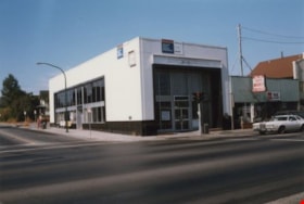
![7342 Curtis Street, [1981] thumbnail](/media/hpo/_Data/_Archives_Images/_Unrestricted/371/382-002.jpg?width=280)
7342 Curtis Street
https://search.heritageburnaby.ca/link/archivedescription38276
- Repository
- City of Burnaby Archives
- Date
- [1981]
- Collection/Fonds
- Burnaby Historical Society fonds
- Description Level
- Item
- Physical Description
- 1 photograph : b&w ; 9 x 12.5 cm
- Scope and Content
- Photograph of the house located at 7342 Curtis Street.
- Repository
- City of Burnaby Archives
- Date
- [1981]
- Collection/Fonds
- Burnaby Historical Society fonds
- Subseries
- Photographs subseries
- Physical Description
- 1 photograph : b&w ; 9 x 12.5 cm
- Description Level
- Item
- Record No.
- 382-002
- Access Restriction
- No restrictions
- Reproduction Restriction
- Reproduce for fair dealing purposes only
- Accession Number
- BHS1999-12
- Scope and Content
- Photograph of the house located at 7342 Curtis Street.
- Subjects
- Buildings - Residential - Houses
- Media Type
- Photograph
- Notes
- Title based on contents of photograph
- Geographic Access
- Curtis Street
- Street Address
- 7342 Curtis Street
- Historic Neighbourhood
- Lochdale (Historic Neighbourhood)
- Planning Study Area
- Lochdale Area
Images
![7342 Curtis Street, [1981] thumbnail](/media/hpo/_Data/_Archives_Images/_Unrestricted/371/382-002.jpg)
Alistair Ross papers
https://search.heritageburnaby.ca/link/archivedescription65732
- Repository
- City of Burnaby Archives
- Date
- [1922]-[1998]
- Collection/Fonds
- Burnaby Historical Society fonds
- Description Level
- Item
- Physical Description
- 1 file of textual records (photocopies)
- Scope and Content
- Item is a four page, typewritten personal memory of growing up in Burnaby (photocopied), specifically of the Burnaby Lake Interurban, written by Alistair Ross.
- Repository
- City of Burnaby Archives
- Date
- [1922]-[1998]
- Collection/Fonds
- Burnaby Historical Society fonds
- Subseries
- Ross family subseries
- Physical Description
- 1 file of textual records (photocopies)
- Description Level
- Item
- Record No.
- MSS146-002
- Access Restriction
- Open access
- Accession Number
- BHS1999-14
- Scope and Content
- Item is a four page, typewritten personal memory of growing up in Burnaby (photocopied), specifically of the Burnaby Lake Interurban, written by Alistair Ross.
- Media Type
- Textual Record
- Notes
- Title based on contents of file
![Burnaby Art Gallery, [1980] thumbnail](/media/hpo/_Data/_Archives_Images/_Unrestricted/316/349-002.jpg?width=280)
Burnaby Art Gallery
https://search.heritageburnaby.ca/link/archivedescription37306
- Repository
- City of Burnaby Archives
- Date
- [1980]
- Collection/Fonds
- Burnaby Historical Society fonds
- Description Level
- Item
- Physical Description
- 1 photograph : b&w ; 10 x 15 cm
- Scope and Content
- Photograph of the exterior of the Burnaby Art Gallery and parking lot. This building was formerly the H. Ceperley family's Fairacres estate, built in 1911.
- Repository
- City of Burnaby Archives
- Date
- [1980]
- Collection/Fonds
- Burnaby Historical Society fonds
- Subseries
- Jim Wolf subseries
- Physical Description
- 1 photograph : b&w ; 10 x 15 cm
- Description Level
- Item
- Record No.
- 349-002
- Access Restriction
- No restrictions
- Reproduction Restriction
- Reproduce for fair dealing purposes only
- Accession Number
- BHS1997-09
- Scope and Content
- Photograph of the exterior of the Burnaby Art Gallery and parking lot. This building was formerly the H. Ceperley family's Fairacres estate, built in 1911.
- Names
- Burnaby Art Gallery
- Media Type
- Photograph
- Photographer
- Houghtaling, Kim
- Notes
- Title based on contents of photograph
- Geographic Access
- Deer Lake Avenue
- Street Address
- 6344 Deer Lake Avenue
- Historic Neighbourhood
- Burnaby Lake (Historic Neighbourhood)
- Planning Study Area
- Douglas-Gilpin Area
Images
![Burnaby Art Gallery, [1980] thumbnail](/media/hpo/_Data/_Archives_Images/_Unrestricted/316/349-002.jpg)

Central Park Pharmacy
https://search.heritageburnaby.ca/link/archivedescription35025
- Repository
- City of Burnaby Archives
- Date
- July 1986
- Collection/Fonds
- Burnaby Historical Society fonds
- Description Level
- Item
- Physical Description
- 1 photograph : b&w ; 8.8 x 12.5 cm
- Scope and Content
- Photograph of the Central Park Pharmacy and Post Office, 3967 Kingsway at Jersey Avenue. A view north up Jersey Avenue can be seen at the left side of the photograph, and Kingsway can be seen at the front and right side of the photo. Signs read, "Central Park Pharmacy," "Drugs," and "Central Park…
- Repository
- City of Burnaby Archives
- Date
- July 1986
- Collection/Fonds
- Burnaby Historical Society fonds
- Subseries
- Evelyn Salisbury subseries
- Physical Description
- 1 photograph : b&w ; 8.8 x 12.5 cm
- Description Level
- Item
- Record No.
- 177-002
- Access Restriction
- No restrictions
- Reproduction Restriction
- Reproduce for fair dealing purposes only
- Accession Number
- BHS1986-25
- Scope and Content
- Photograph of the Central Park Pharmacy and Post Office, 3967 Kingsway at Jersey Avenue. A view north up Jersey Avenue can be seen at the left side of the photograph, and Kingsway can be seen at the front and right side of the photo. Signs read, "Central Park Pharmacy," "Drugs," and "Central Park." Automobiles and a truck are parked on the street. The north shore mountains can be seen in the background.
- Subjects
- Buildings - Commercial - Drugstores
- Names
- Central Park Pharmacy
- Media Type
- Photograph
- Notes
- Title based on contents of photograph
- Geographic Access
- Kingsway
- Jersey Avenue
- Street Address
- 3967 Kingsway
- Historic Neighbourhood
- Central Park (Historic Neighbourhood)
- Planning Study Area
- Garden Village Area
Images

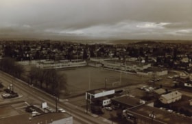
Edmonds School and sports field
https://search.heritageburnaby.ca/link/archivedescription35953
- Repository
- City of Burnaby Archives
- Date
- December 1987
- Collection/Fonds
- Burnaby Historical Society fonds
- Description Level
- Item
- Physical Description
- 1 photograph : sepia ; 12.5 x 17.5 cm print
- Scope and Content
- Photograph of Edmonds Street School, including the sports field, taken from the New Vista Tower.
- Repository
- City of Burnaby Archives
- Date
- December 1987
- Collection/Fonds
- Burnaby Historical Society fonds
- Subseries
- Edmonds School subseries
- Physical Description
- 1 photograph : sepia ; 12.5 x 17.5 cm print
- Description Level
- Item
- Record No.
- 207-002
- Access Restriction
- No restrictions
- Reproduction Restriction
- Reproduce for fair dealing purposes only
- Accession Number
- BHS1988-07
- Scope and Content
- Photograph of Edmonds Street School, including the sports field, taken from the New Vista Tower.
- Names
- Edmonds Community School
- Media Type
- Photograph
- Notes
- Title based on contents of photograph
- Geographic Access
- 18th Avenue
- Street Address
- 7651 18th Avenue
- Historic Neighbourhood
- Edmonds (Historic Neighbourhood)
- Planning Study Area
- Edmonds Area
Images


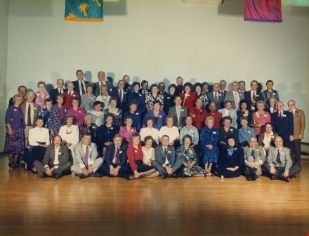
Edmonds School Class Reunion
https://search.heritageburnaby.ca/link/archivedescription38416
- Repository
- City of Burnaby Archives
- Date
- 1989
- Collection/Fonds
- Burnaby Historical Society fonds
- Description Level
- Item
- Physical Description
- 1 photograph : col. ; 20 x 25 cm + 4 p.
- Scope and Content
- Photograph of the members of the grade nine class at Edmonds School from 1949, in 1989, at their 40th reunion.
- Repository
- City of Burnaby Archives
- Date
- 1989
- Collection/Fonds
- Burnaby Historical Society fonds
- Subseries
- Burnaby Retired Teachers subseries
- Physical Description
- 1 photograph : col. ; 20 x 25 cm + 4 p.
- Description Level
- Item
- Record No.
- 434-002
- Access Restriction
- No restrictions
- Reproduction Restriction
- Reproduce for fair dealing purposes only
- Accession Number
- BHS2002-11
- Scope and Content
- Photograph of the members of the grade nine class at Edmonds School from 1949, in 1989, at their 40th reunion.
- Subjects
- Celebrations
- Names
- Edmonds Community School
- Media Type
- Photograph
- Notes
- Title based on contents of photograph
- 4 pages accompanying include an identification key
- Geographic Access
- 18th Avenue
- Street Address
- 7651 18th Avenue
- Historic Neighbourhood
- Edmonds (Historic Neighbourhood)
- Planning Study Area
- Edmonds Area
Images

Empty lot
https://search.heritageburnaby.ca/link/archivedescription38283
- Repository
- City of Burnaby Archives
- Date
- 1987
- Collection/Fonds
- Burnaby Historical Society fonds
- Description Level
- Item
- Physical Description
- 1 photograph : col. ; 8.9 x 11 cm
- Scope and Content
- Photograph of the site of Bonsor Hall, on Fern Avenue, after demolition. A blue car is visible.
- Repository
- City of Burnaby Archives
- Date
- 1987
- Collection/Fonds
- Burnaby Historical Society fonds
- Subseries
- Photographs subseries
- Physical Description
- 1 photograph : col. ; 8.9 x 11 cm
- Description Level
- Item
- Record No.
- 386-002
- Access Restriction
- No restrictions
- Reproduction Restriction
- Reproduce for fair dealing purposes only
- Accession Number
- BHS2007-04
- Scope and Content
- Photograph of the site of Bonsor Hall, on Fern Avenue, after demolition. A blue car is visible.
- Subjects
- Transportation - Automobiles
- Media Type
- Photograph
- Notes
- Title based on contents of photograph
- Geographic Access
- Fern Avenue
- Historic Neighbourhood
- Central Park (Historic Neighbourhood)
- Planning Study Area
- Marlborough Area
Images


Former site of the Kelly Douglas building
https://search.heritageburnaby.ca/link/archivedescription35028
- Repository
- City of Burnaby Archives
- Date
- August 18, 1986
- Collection/Fonds
- Burnaby Historical Society fonds
- Description Level
- Item
- Physical Description
- 1 photograph : col. ; 8.8 x 12.6 cm
- Scope and Content
- Photograph of the site of Kelly Douglas and Co. at 4700 Kingsway after the building was demolished. Buildings and the Skytrain Expo line are visible in the background.
- Repository
- City of Burnaby Archives
- Date
- August 18, 1986
- Collection/Fonds
- Burnaby Historical Society fonds
- Subseries
- Evelyn Salisbury subseries
- Physical Description
- 1 photograph : col. ; 8.8 x 12.6 cm
- Description Level
- Item
- Record No.
- 178-002
- Access Restriction
- No restrictions
- Reproduction Restriction
- Reproduce for fair dealing purposes only
- Accession Number
- BHS1986-26
- Scope and Content
- Photograph of the site of Kelly Douglas and Co. at 4700 Kingsway after the building was demolished. Buildings and the Skytrain Expo line are visible in the background.
- Media Type
- Photograph
- Notes
- Title based on contents of photograph
- Geographic Access
- Kingsway
- Street Address
- 4700 Kingsway
- Historic Neighbourhood
- Central Park (Historic Neighbourhood)
- Planning Study Area
- Maywood Area
Images


Naud house
https://search.heritageburnaby.ca/link/archivedescription38295
- Repository
- City of Burnaby Archives
- Date
- 1985
- Collection/Fonds
- Burnaby Historical Society fonds
- Description Level
- Item
- Physical Description
- 1 photograph : b&w ; 12.5 x 17.5 cm
- Scope and Content
- Photograph of the Naud house, at 4737 Victory Street. This home was built by Onzieme Naud and is now a protected heritage site in Burnaby.
- Repository
- City of Burnaby Archives
- Date
- 1985
- Collection/Fonds
- Burnaby Historical Society fonds
- Subseries
- Photographs subseries
- Physical Description
- 1 photograph : b&w ; 12.5 x 17.5 cm
- Description Level
- Item
- Record No.
- 398-002
- Access Restriction
- No restrictions
- Reproduction Restriction
- Reproduce for fair dealing purposes only
- Accession Number
- BHS2007-04
- Scope and Content
- Photograph of the Naud house, at 4737 Victory Street. This home was built by Onzieme Naud and is now a protected heritage site in Burnaby.
- Media Type
- Photograph
- Notes
- Title based on contents of photograph
- Geographic Access
- Victory Street
- Street Address
- 4737 Victory Street
- Historic Neighbourhood
- Alta-Vista (Historic Neighbourhood)
- Planning Study Area
- Sussex-Nelson Area
Images

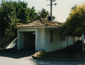
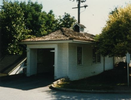
Oakalla Warden's House
https://search.heritageburnaby.ca/link/archivedescription34854
- Repository
- City of Burnaby Archives
- Date
- 1985
- Collection/Fonds
- Burnaby Historical Society fonds
- Description Level
- Item
- Physical Description
- 1 photograph : col. ; 8.8 x 11.3 cm
- Scope and Content
- Photograph of the Warden's house and garage at Oakalla Prison Farm, Royal Oak Road.
- Repository
- City of Burnaby Archives
- Date
- 1985
- Collection/Fonds
- Burnaby Historical Society fonds
- Subseries
- Evelyn Salisbury subseries
- Physical Description
- 1 photograph : col. ; 8.8 x 11.3 cm
- Description Level
- Item
- Record No.
- 145-002
- Access Restriction
- No restrictions
- Reproduction Restriction
- Reproduce for fair dealing purposes only
- Accession Number
- BHS1985-15
- Scope and Content
- Photograph of the Warden's house and garage at Oakalla Prison Farm, Royal Oak Road.
- Names
- Oakalla Prison Farm
- Media Type
- Photograph
- Notes
- Title based on contents of photograph
- Geographic Access
- Oakmount Crescent
- Street Address
- 5220 Oakmount Crescent
- Historic Neighbourhood
- Burnaby Lake (Historic Neighbourhood)
- Planning Study Area
- Oakalla Area
Images

Our Lady of Mercy Church Manse
https://search.heritageburnaby.ca/link/archivedescription35075
- Repository
- City of Burnaby Archives
- Date
- October 21, 1986
- Collection/Fonds
- Burnaby Historical Society fonds
- Description Level
- Item
- Physical Description
- 1 photograph : b&w ; 8.8 x 12.6 cm
- Scope and Content
- Photograph of the exterior of the manse at Our Lady of Mercy Catholic Church, 7455 10th Avenue and Kingsway. The photo was taken before the manse was demolished. An automobile is parked outside.
- Repository
- City of Burnaby Archives
- Date
- October 21, 1986
- Collection/Fonds
- Burnaby Historical Society fonds
- Subseries
- Jim Wolf subseries
- Physical Description
- 1 photograph : b&w ; 8.8 x 12.6 cm
- Description Level
- Item
- Record No.
- 188-002
- Access Restriction
- No restrictions
- Reproduction Restriction
- Reproduce for fair dealing purposes only
- Accession Number
- BHS1986-39
- Scope and Content
- Photograph of the exterior of the manse at Our Lady of Mercy Catholic Church, 7455 10th Avenue and Kingsway. The photo was taken before the manse was demolished. An automobile is parked outside.
- Subjects
- Buildings - Religious - Churches
- Names
- Our Lady of Mercy Church
- Media Type
- Photograph
- Photographer
- Wolf, Jim
- Notes
- Title based on contents of photograph
- Geographic Access
- 10th Avenue
- Street Address
- 7455 10th Avenue
- Historic Neighbourhood
- Edmonds (Historic Neighbourhood)
- Planning Study Area
- Edmonds Area
Images

![Parking Lot and Burnaby Art Gallery, [1980] thumbnail](/media/hpo/_Data/_Archives_Images/_Unrestricted/371/420-002.jpg?width=280)
Parking Lot and Burnaby Art Gallery
https://search.heritageburnaby.ca/link/archivedescription38368
- Repository
- City of Burnaby Archives
- Date
- [1980]
- Collection/Fonds
- Burnaby Historical Society fonds
- Description Level
- Item
- Physical Description
- 1 photograph : b&w ; 10 x 14.9 cm
- Scope and Content
- Photograph of the parking lot and entrance to the Burnaby Art Gallery (formerly the Ceperley House) in Deer Lake park.
- Repository
- City of Burnaby Archives
- Date
- [1980]
- Collection/Fonds
- Burnaby Historical Society fonds
- Subseries
- Municipal record subseries
- Physical Description
- 1 photograph : b&w ; 10 x 14.9 cm
- Description Level
- Item
- Record No.
- 420-002
- Access Restriction
- No restrictions
- Reproduction Restriction
- Reproduce for fair dealing purposes only
- Accession Number
- BHS2001-09
- Scope and Content
- Photograph of the parking lot and entrance to the Burnaby Art Gallery (formerly the Ceperley House) in Deer Lake park.
- Names
- Burnaby Art Gallery
- Media Type
- Photograph
- Notes
- Title based on contents of photograph.
- Geographic Access
- Deer Lake Avenue
- Street Address
- 6344 Deer Lake Avenue
- Historic Neighbourhood
- Burnaby Lake (Historic Neighbourhood)
- Planning Study Area
- Douglas-Gilpin Area
Images
![Parking Lot and Burnaby Art Gallery, [1980] thumbnail](/media/hpo/_Data/_Archives_Images/_Unrestricted/371/420-002.jpg)
Royal Bank on Kingsway at McKay Avenue
https://search.heritageburnaby.ca/link/archivedescription36465
- Repository
- City of Burnaby Archives
- Date
- July 1985
- Collection/Fonds
- Burnaby Historical Society fonds
- Description Level
- Item
- Physical Description
- 1 photograph : col. ; 10 x 15 cm
- Scope and Content
- Photograph of the former Royal Bank building on Kingsway at McKay Avenue, taken from Kingsway, looking up McKay Avenue. Vera Jackson Pel worked at this branch of the Royal Bank from 1944 until 1952.
- Repository
- City of Burnaby Archives
- Date
- July 1985
- Collection/Fonds
- Burnaby Historical Society fonds
- Subseries
- Vera Jackson Pel subseries
- Physical Description
- 1 photograph : col. ; 10 x 15 cm
- Description Level
- Item
- Record No.
- 274-002
- Access Restriction
- No restrictions
- Reproduction Restriction
- Reproduce for fair dealing purposes only
- Accession Number
- BHS1992-04
- Scope and Content
- Photograph of the former Royal Bank building on Kingsway at McKay Avenue, taken from Kingsway, looking up McKay Avenue. Vera Jackson Pel worked at this branch of the Royal Bank from 1944 until 1952.
- Subjects
- Buildings - Commercial - Banks
- Names
- Royal Bank of Canada
- Media Type
- Photograph
- Notes
- Title based on contents of photograph
- Geographic Access
- Kingsway
- McKay Avenue
- Historic Neighbourhood
- Central Park (Historic Neighbourhood)
- Planning Study Area
- Maywood Area
Images

Seaforth School dedication
https://search.heritageburnaby.ca/link/archivedescription35125
- Repository
- City of Burnaby Archives
- Date
- April 1987
- Collection/Fonds
- Burnaby Historical Society fonds
- Description Level
- Item
- Physical Description
- 1 photograph : col. ; 12.6 x 17.4 cm print
- Scope and Content
- Photograph of the opening of Seaforth School, Burnaby Village Museum. An annotation on the back of the photograph reads, "X-students of Seaforth School following Brig. Bell-Irving / April, 1987 / Dedication of Seaforth School - Bby Heritage Village." The school was moved from its original locatio…
- Repository
- City of Burnaby Archives
- Date
- April 1987
- Collection/Fonds
- Burnaby Historical Society fonds
- Subseries
- Donald N. Brown subseries
- Physical Description
- 1 photograph : col. ; 12.6 x 17.4 cm print
- Description Level
- Item
- Record No.
- 194-002
- Access Restriction
- No restrictions
- Reproduction Restriction
- Reproduce for fair dealing purposes only
- Accession Number
- BHS1987-03
- Scope and Content
- Photograph of the opening of Seaforth School, Burnaby Village Museum. An annotation on the back of the photograph reads, "X-students of Seaforth School following Brig. Bell-Irving / April, 1987 / Dedication of Seaforth School - Bby Heritage Village." The school was moved from its original location at 7881 Government Road to Burnaby Village Museum in 1983, and was opened to the public in 1987.
- Subjects
- Events - Openings
- Media Type
- Photograph
- Notes
- Title based on contents of photograph
- Geographic Access
- Deer Lake Avenue
- Street Address
- 6501 Deer Lake Avenue
- Historic Neighbourhood
- Burnaby Lake (Historic Neighbourhood)
- Planning Study Area
- Morley-Buckingham Area
Images
1980-1981 Provisional Accountability Budget
https://search.heritageburnaby.ca/link/archivedescription58396
- Repository
- City of Burnaby Archives
- Date
- November 7, 1980
- Collection/Fonds
- Burnaby Historical Society fonds
- Description Level
- Item
- Physical Description
- 1 booklet
- Scope and Content
- Item is the "1980 Recast / 1981 Provisional / Accountability Budget" for the District of Burnaby as laid out by the Municipal Manager for Council's inspection and approval.
- Repository
- City of Burnaby Archives
- Date
- November 7, 1980
- Collection/Fonds
- Burnaby Historical Society fonds
- Subseries
- Municipal record subseries
- Physical Description
- 1 booklet
- Description Level
- Item
- Record No.
- MSS081-009
- Accession Number
- BHS1996-10
- Scope and Content
- Item is the "1980 Recast / 1981 Provisional / Accountability Budget" for the District of Burnaby as laid out by the Municipal Manager for Council's inspection and approval.
- Media Type
- Textual Record
- Notes
- Title based on contents of item
1983 - 1987 Capital Budget
https://search.heritageburnaby.ca/link/archivedescription58395
- Repository
- City of Burnaby Archives
- Date
- April 22, 1983
- Collection/Fonds
- Burnaby Historical Society fonds
- Description Level
- Item
- Physical Description
- 1 booklet
- Scope and Content
- Item is the proposed "1983-1987 Capital Budget" for the District of Burnaby as laid out by the Municipal Manager for Council's approval.
- Repository
- City of Burnaby Archives
- Date
- April 22, 1983
- Collection/Fonds
- Burnaby Historical Society fonds
- Subseries
- Municipal record subseries
- Physical Description
- 1 booklet
- Description Level
- Item
- Record No.
- MSS081-008
- Accession Number
- BHS1996-10
- Scope and Content
- Item is the proposed "1983-1987 Capital Budget" for the District of Burnaby as laid out by the Municipal Manager for Council's approval.
- Media Type
- Textual Record
![4674 Southlawn Drive, [1989 or 1990] (date of original), copied 1991 thumbnail](/media/hpo/_Data/_Archives_Images/_Unrestricted/370/370-463.jpg?width=280)
4674 Southlawn Drive
https://search.heritageburnaby.ca/link/archivedescription37875
- Repository
- City of Burnaby Archives
- Date
- [1989 or 1990] (date of original), copied 1991
- Collection/Fonds
- Burnaby Historical Society fonds
- Description Level
- Item
- Physical Description
- 1 photograph : b&w ; 3.7 x 4.7 cm print on contact sheet 20.1 x 26.7 cm
- Scope and Content
- Photograph taken from 4674 Southlawn Drive after a snowfall, facing northwest.
- Repository
- City of Burnaby Archives
- Date
- [1989 or 1990] (date of original), copied 1991
- Collection/Fonds
- Burnaby Historical Society fonds
- Subseries
- Burnaby Image Bank subseries
- Physical Description
- 1 photograph : b&w ; 3.7 x 4.7 cm print on contact sheet 20.1 x 26.7 cm
- Description Level
- Item
- Record No.
- 370-463
- Access Restriction
- No restrictions
- Reproduction Restriction
- No restrictions
- Accession Number
- BHS1999-03
- Scope and Content
- Photograph taken from 4674 Southlawn Drive after a snowfall, facing northwest.
- Media Type
- Photograph
- Notes
- Title based on contents of photograph
- 1 b&w copy negative accompanying
- Negative has a pink cast
- Copied from col. photograph
- Geographic Access
- Southlawn Drive
- Planning Study Area
- Brentwood Area
Images
![4674 Southlawn Drive, [1989 or 1990] (date of original), copied 1991 thumbnail](/media/hpo/_Data/_Archives_Images/_Unrestricted/370/370-463.jpg)

6113 Silver Avenue lot
https://search.heritageburnaby.ca/link/archivedescription37775
- Repository
- City of Burnaby Archives
- Date
- 1986 (date of original), copied 1991
- Collection/Fonds
- Burnaby Historical Society fonds
- Description Level
- Item
- Physical Description
- 1 photograph : b&w ; 3.1 x 4.4 cm print on contact sheet 20.3 x 26.2 cm
- Scope and Content
- Photograph of the lot at 6113 Silver Avenue, the former home of the Ellis family. The house has been demolished and an empty lot remains. Houses, aparment buildings, and the Expo line skytrain track with cars on it can be seen in the background.
- Repository
- City of Burnaby Archives
- Date
- 1986 (date of original), copied 1991
- Collection/Fonds
- Burnaby Historical Society fonds
- Subseries
- Burnaby Image Bank subseries
- Physical Description
- 1 photograph : b&w ; 3.1 x 4.4 cm print on contact sheet 20.3 x 26.2 cm
- Description Level
- Item
- Record No.
- 370-363
- Access Restriction
- No restrictions
- Reproduction Restriction
- No restrictions
- Accession Number
- BHS1999-03
- Scope and Content
- Photograph of the lot at 6113 Silver Avenue, the former home of the Ellis family. The house has been demolished and an empty lot remains. Houses, aparment buildings, and the Expo line skytrain track with cars on it can be seen in the background.
- Subjects
- Land Clearing
- Media Type
- Photograph
- Notes
- Title based on contents of photograph
- 1 b&w copy negative accompanying
- Negative has a pink cast
- Copied from col. photograph
- Geographic Access
- Silver Avenue
- Street Address
- 6113 Silver Avenue
- Historic Neighbourhood
- Central Park (Historic Neighbourhood)
- Planning Study Area
- Maywood Area
Images


6742 Walker Avenue
https://search.heritageburnaby.ca/link/archivedescription37844
- Repository
- City of Burnaby Archives
- Date
- May 1987 (date of original), copied 1991
- Collection/Fonds
- Burnaby Historical Society fonds
- Description Level
- Item
- Physical Description
- 1 photograph : b&w ; 3.1 x 4.3 cm print on contact sheet 20.6 x 26.7 cm
- Scope and Content
- Photograph of 6742 Walker Avenue, with only the trees in the yard visible from the road. A van is parked in front.
- Repository
- City of Burnaby Archives
- Date
- May 1987 (date of original), copied 1991
- Collection/Fonds
- Burnaby Historical Society fonds
- Subseries
- Burnaby Image Bank subseries
- Physical Description
- 1 photograph : b&w ; 3.1 x 4.3 cm print on contact sheet 20.6 x 26.7 cm
- Description Level
- Item
- Record No.
- 370-432
- Access Restriction
- No restrictions
- Reproduction Restriction
- No restrictions
- Accession Number
- BHS1999-03
- Scope and Content
- Photograph of 6742 Walker Avenue, with only the trees in the yard visible from the road. A van is parked in front.
- Subjects
- Plants - Trees
- Media Type
- Photograph
- Notes
- Title based on contents of photograph
- 1 b&w copy negative accompanying
- Negative has a pink cast
- Copied from col. photograph
- Geographic Access
- Walker Avenue
- Street Address
- 6742 Walker Avenue
- Historic Neighbourhood
- Edmonds (Historic Neighbourhood)
- Planning Study Area
- Richmond Park Area
Images


6742 Walker Avenue
https://search.heritageburnaby.ca/link/archivedescription37845
- Repository
- City of Burnaby Archives
- Date
- May 1987 (date of original), copied 1991
- Collection/Fonds
- Burnaby Historical Society fonds
- Description Level
- Item
- Physical Description
- 1 photograph : b&w ; 3.0 x 4.4 cm print on contact sheet 20.6 x 26.7 cm
- Scope and Content
- Photograph of 6742 Walker Avenue with some of the trees in the yard cut down.
- Repository
- City of Burnaby Archives
- Date
- May 1987 (date of original), copied 1991
- Collection/Fonds
- Burnaby Historical Society fonds
- Subseries
- Burnaby Image Bank subseries
- Physical Description
- 1 photograph : b&w ; 3.0 x 4.4 cm print on contact sheet 20.6 x 26.7 cm
- Description Level
- Item
- Record No.
- 370-433
- Access Restriction
- No restrictions
- Reproduction Restriction
- No restrictions
- Accession Number
- BHS1999-03
- Scope and Content
- Photograph of 6742 Walker Avenue with some of the trees in the yard cut down.
- Subjects
- Plants - Trees
- Media Type
- Photograph
- Notes
- Title based on contents of photograph
- 1 b&w copy negative accompanying
- Negative has a pink cast
- Copied from col. photograph
- Geographic Access
- Walker Avenue
- Street Address
- 6742 Walker Avenue
- Historic Neighbourhood
- Edmonds (Historic Neighbourhood)
- Planning Study Area
- Richmond Park Area
Images
