Narrow Results By
North Pacific Lumber Company Ruins
https://search.heritageburnaby.ca/link/landmark627
- Repository
- Burnaby Heritage Planning
- Geographic Access
- Barnet Road
- Associated Dates
- 1909
- Description
- Industrial building.
- Heritage Value
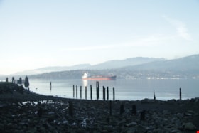
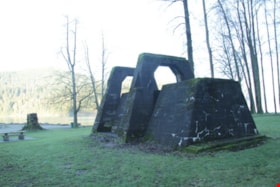
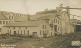
- Located on the shore of Burrard Inlet, these poured concrete piers of the smokestack burner and the former boiler and plant of the North Pacific Lumber Company are among the only remains of the once-thriving industrial site located on the waterfront on the south shore of Burrard Inlet. The sawmill and the Village of Barnet were initiated by David MacLaren, a wealthy lumberman from Buckingham, Quebec, who had previously established the Fraser Mills in Coquitlam in 1889. McLaren gambled that a sawmill on the main line of the C.P.R near Vancouver would serve the Canadian domestic market and be a profitable venture. The North Pacific Lumber Company established itself on this peninsula on Burrard Inlet and was fully operational in 1900. In 1909, the mill was completely burned out by a fire starting in the boiler room. Immediately the plant was rebuilt, modern in every respect and absolutely fireproof, as the entire power plant and boiler room was built of reinforced concrete and steel, of which these ruins are the last remains. The plant closed during the First World War and reopened as the Barnet Lumber Company in 1925 only to close forever in 1931 after a strike during the Great Depression.
- Locality
- Barnet
- Historic Neighbourhood
- Barnet (Historic Neighbourhood)
- Planning Study Area
- Burnaby Mountain Area
Images
Simon Fraser University
https://search.heritageburnaby.ca/link/landmark639
- Repository
- Burnaby Heritage Planning
- Description
- The planning, design concept, design coordination, site development and landscaping for the original part of the campus were all under the control of Erickson/Massey. The complex was conceived as one building, with future growth occurring at the periphery. Tall buildings would have been out of scal…
- Associated Dates
- 1965
- Street View URL
- Google Maps Street View
- Repository
- Burnaby Heritage Planning
- Geographic Access
- University Drive
- Associated Dates
- 1965
- Description
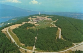
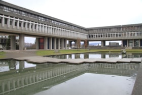
- The planning, design concept, design coordination, site development and landscaping for the original part of the campus were all under the control of Erickson/Massey. The complex was conceived as one building, with future growth occurring at the periphery. Tall buildings would have been out of scale with the massive mountaintop ridge, so a series of horizontal terraced structures were designed that hugged the ridge and dissolve into the landscape. Following the linear peak of the mountain, the scheme organized various parts of the campus along an east/west line. The concept of a central academic quadrangle was conceived within the tradition of Oxford and Cambridge, and to enhance the sense of contemplative quiet, it was designed as a perfect square raised on massive pilotis, allowing stunning views through a landscaped courtyard. The connecting link was a gigantic space frame-developed in conjunction with Jeffrey Lindsay, a one-time associate of Buckminster Fuller-that provided shelter and a gathering-place for the students. Other architects who had placed among the top five in the competition were retained to design the individual components of the original plan: the Academic Quadrangle by Zoltan S. Kiss; the Theatre, Gymnasium & Swimming Pool by Duncan McNab & Associates; the Science Complex by Rhone & Iredale; and the Library by Robert F. Harrison.
- Heritage Value
- Following the end of the Second World War, there was unprecedented growth throughout the Lower Mainland. Many returning veterans had settled on the coast, and the loosening of wartime restrictions led to the creation of many new suburban developments throughout the region. The growing population strained existing facilities, and there was a recognition that new educational facilities had to be constructed to meet these growing demands. For many years, the only university in the province was the University of British Columbia. In the 1960s, new universities were planned for both Victoria and Burnaby to serve the wave of baby boomers just then going through high school. The dramatic site chosen for the Burnaby university was the top of Burnaby Mountain, with expansive views over mountain ranges and water. An architectural competition was held for a campus of 7,000 students that could eventually be expanded to 18,000. Of the many submissions, the judges reached unanimity on the winner, an outstanding scheme submitted by the firm of Erickson/Massey. The judges went even further, and recommended that every effort be made to ensure that the winning design be built as submitted. The new Chancellor, Gordon Shrum, agreed. The realization of this scheme won extensive recognition for the work of Arthur Erickson and Geoffrey Massey, and launched Erickson’s international career. In Erickson’s words: "Unlike any previous university, Simon Fraser is a direct translation into architecture of the expanding fields of knowledge that defy traditional boundaries, of the vital role of the university as both challenger and conservor of human culture, and of the university community as one in constant intellectual, spiritual and social interchange." The new school opened for classes in September 1965, nicknamed the “instant university,” and quickly gained a radical reputation. The startling futuristic architecture and open layout suited the explosive nature of the mid-1960s, when political and social traditions of all types were being questioned and student protests were common. Many of SFU’s programs were considered experimental, even controversial, and unrest and conflict on the campus continued for a number of years. Since this auspicious beginning 40 years ago, SFU has grown to house 25,000 students on three campuses. The core of the original campus, recognized world-wide as a profound work of architecture, remains essentially intact today.
- Locality
- Burnaby Mountain
- Historic Neighbourhood
- Barnet (Historic Neighbourhood)
- Planning Study Area
- Burnaby Mountain Area
- Architect
- Erickson/Massey
- Area
- 1360000.00
- Contributing Resource
- Building
- Ownership
- Private
- Street Address
- 8888 University Drive
- Street View URL
- Google Maps Street View
Images
Thomas & Margaret Coldicutt Residence
https://search.heritageburnaby.ca/link/landmark647
- Repository
- Burnaby Heritage Planning
- Description
- Residential building.
- Associated Dates
- 1911
- Street View URL
- Google Maps Street View
- Repository
- Burnaby Heritage Planning
- Geographic Access
- 6th Street
- Associated Dates
- 1911
- Description
- Residential building.
- Heritage Value
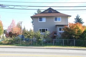
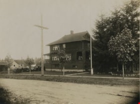
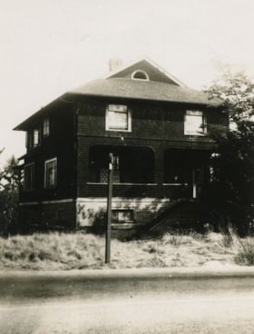
- This house was built by Thomas Davis Coldicutt (1879-1970) and Margaret Jane Coldicutt, pre-eminent local citizens. Thomas Coldicutt was born in Birmingham and arrived in Canada in 1900, finding success in the steamboat industry. In 1902, he married Margaret Jane Styler who had been born in Redditch, Worcester, England, and in 1908 they settled in East Burnaby–some of the first pioneers to the area–and established a fruit farm. Thomas had a successful real estate, insurance and brokerage business, and was elected as a councillor for East Burnaby in 1909. He was also active in civic, political and social circles in Burnaby and became president of the Burnaby Board of Trade. "East Burnaby is booming and the signs of prosperity that may be seen on every hand. Most of these are substantial dwellings, such as effect a permanent improvement to the countryside. Among those whose homes have been completed, or on the point of completion may be mentioned. Councillor Coldicutt, who has built himself a habitation on Second Avenue at a cost of $4,000. (The British Columbian, 1911). In 1913, Coldicutt sold his original farm described as “the show place of Burnaby” to the Burnaby School Board for the development of Second Street School and this house was moved from Second Street and Sixteenth Avenue to this site. It has been extensively altered, but retains its original form, scale and massing.
- Locality
- East Burnaby
- Historic Neighbourhood
- East Burnaby (Historic Neighbourhood)
- Planning Study Area
- Edmonds Area
- Area
- 557.42
- Contributing Resource
- Building
- Ownership
- Private
- Street Address
- 7510 6th Street
- Street View URL
- Google Maps Street View
