Narrow Results By
Subject
- Buildings 1
- Buildings - Residential 1
- Buildings - Residential - Apartments 1
- Documentary Artifacts 2
- Documentary Artifacts - Leaflets 1
- Documentary Artifacts - Postcards 1
- First Nations reserves - British Columbia 2
- Indigenous peoples - Indian Territory 2
- Organizations - Girls' Societies and Clubs 4
Creator
- Baden-Powell of Gilwell, Robert Stephenson Smyth Baden-Powell, Baron, 1857-1941 2
- Burnaby, Robert, 1828-1878 1
- Burnett, Geoffrey K. 1
- Fassett, James H. (James Hiram), 1869-1930 1
- Garden, Hermon and Burwell 1
- Garden, Hermon & Burwell 1
- Government of Canada - Department of Mines - Geological Survey Branch 1
- Hill, Albert James 7
- McGeachie, Pixie, 1921- 1
- McLeod, Anne Burnaby 1
- Remington, Joseph P. (Joseph Price), 1847-1918 1
- Smith, H. Neville 1
The beacon second reader
https://search.heritageburnaby.ca/link/museumlibrary2157
- Repository
- Burnaby Village Museum
- Collection
- Special Collection
- Material Type
- Book
- Accession Code
- HV978.53.1
- Call Number
- 372.41 GIN
- Place of Publication
- Boston
- Publisher
- Ginn & Company
- Publication Date
- c1914
- Physical Description
- 192 p. : ill ; 19 cm.
- Inscription
- "School Dist. No.81 / Columbia Building / Grade No" - stamped on behind front cover ; "n.3" -- handwritten in ink under the stamp "School Dist. No. 301 / Bellingham, Wash. / Corrected No. 102 / 1922" -- stamped on endpaper (front). ; "102" handwritten in ink under the stamp "Bellingham, Wash. / School 301 Dist." -- stamped on behind front cover ; "Date 9-1-20 / F.B. Road II / No. 76" handwritten in ink under the stamp "PEAPL / a" -- handwritten in pencil on front cover paper "4 / 2" -- handwritten in pencil on flyleaf.
- Library Subject (LOC)
- Fairy tales
- Readers (Elementary)
- Notes
- Includes index.
- Author full name: Fassett, James H. (James Hiram), 1869-1930.
![Subdivision plans in New Westminster District Group 1 – Burnaby
, [1900-1910] thumbnail](/media/hpo/_Data/_BVM_Cartographic_Material/1977/1977_0093_0009a_001.jpg?width=280)
Subdivision plans in New Westminster District Group 1 – Burnaby
https://search.heritageburnaby.ca/link/museumdescription6978
- Repository
- Burnaby Village Museum
- Date
- [1900-1910]
- Collection/Fonds
- Burnaby Village Museum Map collection
- Description Level
- File
- Physical Description
- 4 plans : blueprint ink on paper mounted on 2 sides of cardboard 76 x 102 cm
- Scope and Content
- Item consists of a large board with two New Westminster District Gp 1 - subdivision plans mounted on one side and two New Westminster District Gp 1 - subdivision plans mounted on the other side. Side A: 1. Blueprint "Plan/ of Subdivisions / of portions / of / Lot 91, / Group 1 / New Westminster …
- Repository
- Burnaby Village Museum
- Collection/Fonds
- Burnaby Village Museum Map collection
- Description Level
- File
- Physical Description
- 4 plans : blueprint ink on paper mounted on 2 sides of cardboard 76 x 102 cm
- Material Details
- Scales [between 1:792 and 1:2376]
- Index number on edge of board reads: "9"
- Scope and Content
- Item consists of a large board with two New Westminster District Gp 1 - subdivision plans mounted on one side and two New Westminster District Gp 1 - subdivision plans mounted on the other side. Side A: 1. Blueprint "Plan/ of Subdivisions / of portions / of / Lot 91, / Group 1 / New Westminster Dist. / Scale 3 chs = 1 in / Map Nos 535 & 506". (Geographic location: Burnaby) 2. Blueprint "Plan / of / Subdivision of a Portion / of / Lot 28 / Group One / New Westminster Dist. / Scale 1 chs = 1 in / Map No 274". Lots are identified as "I / II / III / VI / V / IV ". The plan is bordered by First Avenue, Suburban Lands and Cemetery at the bottom, 13th Street at the top, Douglas Road to the west and 4th Street to the east. The plan is signed by "W. Thibaudeau". (Geographic location: Burnaby) Side B: 1. Blueprint "Plan / of the Subdivision of a Portion / of / Lot 29 / Group One / New Westminster District / Scale 1ch = 1 in / Map No 291 _ Subdivision 'L'". (Geographic location: Burnaby) 2. Blueprint " Plan of Subdivision / of / Lot 27 / Group One / New Westminster Dist. / Scale 3 chs = 1 in. / Map No. 697". (Geographic location: Burnaby)
- Accession Code
- HV977.93.9
- Access Restriction
- No restrictions
- Reproduction Restriction
- No known restrictions
- Date
- [1900-1910]
- Media Type
- Cartographic Material
- Scan Resolution
- 300
- Scale
- 72
- Notes
- Title based on contents of file
- Scale is measured in chains. (One chain equals 792 inches)
- The term "Lot" can also refer to a "District Lot”
Images
![Subdivision plans in New Westminster District Group 1 – Burnaby
, [1900-1910] thumbnail](/media/hpo/_Data/_BVM_Cartographic_Material/1977/1977_0093_0009a_001.jpg)

![Subdivision plans in New Westminster District Group 1 – Burnaby
, [1900-1910] thumbnail](/media/hpo/_Data/_BVM_Cartographic_Material/1977/1977_0093_0012a_001.jpg?width=280)
Subdivision plans in New Westminster District Group 1 – Burnaby
https://search.heritageburnaby.ca/link/museumdescription6981
- Repository
- Burnaby Village Museum
- Date
- [1900-1910]
- Collection/Fonds
- Burnaby Village Museum Map collection
- Description Level
- File
- Physical Description
- 4 plans : blueprint ink on paper mounted on 2 sides of cardboard 76 x 102 cm
- Scope and Content
- Item consists of a large board of two New Westminster District Gp 1 - subdivision plans mounted on one side and two New Westminster District Gp 1 -subdivision plans mounted on the other side. Side A: 1. Blueprint "Plan / shewing [sic] / Subdivision of / Lot 162 / Group One / New Westmisnter Dis…
- Repository
- Burnaby Village Museum
- Collection/Fonds
- Burnaby Village Museum Map collection
- Description Level
- File
- Physical Description
- 4 plans : blueprint ink on paper mounted on 2 sides of cardboard 76 x 102 cm
- Material Details
- Scales [1:2376] and [1:3168]
- Index number on edge of board reads: "12"
- Scope and Content
- Item consists of a large board of two New Westminster District Gp 1 - subdivision plans mounted on one side and two New Westminster District Gp 1 -subdivision plans mounted on the other side. Side A: 1. Blueprint "Plan / shewing [sic] / Subdivision of / Lot 162 / Group One / New Westmisnter Dist. / Scale 4 chs = 1 in. / Map No 450". Plan is signed by "Sidney Williams / Provincial Land Surveyor" (Geographic location: Burnaby) 2. Blueprint "Plan of / Subdivision of / Block 166A / Grroup One, / Westminster District / Scale 4 chs = 1 in. / Map No 524". Plan is signed by "Sidney Williams / Provincial Land Surveyor" (Geographic location: Burnaby) Side B: 1. Blueprint "Plan / of / Subdivision of Lot 77, Group 1 / New Westminster Dist. / Scale = 4 chs = 1 in. / Map No 238" Plan is signed by "Gardue [sic] Hermon [sic] / District [sic] Land Surveyor" (Geographic location: Burnaby) 2. Blueprint " Plan / of Subdivision / of part / of / Lot 95 / Group One / New Westminster Dist. / Sclae 3 chs = 1 in. / Map No 556". (Geographic location: Burnaby)
- Creator
- Williams, Sidney
- Accession Code
- HV977.93.12
- Access Restriction
- No restrictions
- Reproduction Restriction
- No known restrictions
- Date
- [1900-1910]
- Media Type
- Cartographic Material
- Scan Resolution
- 300
- Scale
- 72
- Notes
- Title based on contents of file
- Scale is measured in chains. (One chain equals 792 inches)
- The term "Lot" can also refer to a "District Lot”
Images
![Subdivision plans in New Westminster District Group 1 – Burnaby
, [1900-1910] thumbnail](/media/hpo/_Data/_BVM_Cartographic_Material/1977/1977_0093_0012a_001.jpg)

![Survey and Subdivision plans in New Westminster District Group 1 – Burnaby, [1905-1917] thumbnail](/media/hpo/_Data/_BVM_Cartographic_Material/1977/1977_0093_0022a_001.jpg?width=280)
Survey and Subdivision plans in New Westminster District Group 1 – Burnaby
https://search.heritageburnaby.ca/link/museumdescription6991
- Repository
- Burnaby Village Museum
- Date
- [1905-1917]
- Collection/Fonds
- Burnaby Village Museum Map collection
- Description Level
- File
- Physical Description
- 12 plans : 6 black ink on paper + 2 black & col. ink on paper + 4 graphite on paper
- Scope and Content
- Item consists of a large board of six New Westminster District subdivision plans mounted on one side and six New Westminster District subdivision plans mounted on the other side. Side A: 1. Plan drawn in graphite with markings in black ink "Surveyed for Mr. W. Wilson / Paterson Stat. B.C.E.R." . …
- Repository
- Burnaby Village Museum
- Collection/Fonds
- Burnaby Village Museum Map collection
- Description Level
- File
- Physical Description
- 12 plans : 6 black ink on paper + 2 black & col. ink on paper + 4 graphite on paper
- Material Details
- Scales [between 1:360 and 1:3168]
- Index number on edge of board reads: "22"
- Scope and Content
- Item consists of a large board of six New Westminster District subdivision plans mounted on one side and six New Westminster District subdivision plans mounted on the other side. Side A: 1. Plan drawn in graphite with markings in black ink "Surveyed for Mr. W. Wilson / Paterson Stat. B.C.E.R." . Plan includes subdivision of lots situated between B.C.E. Railway and Vancouver Road (Kingsway). (Geographic location: Burnaby) 2. Subdivision plan (no title) drawn in black ink with annotations in graphite. Plan covers District Lots 2, 4 and 6, west of North Road. Plan is stamped: "Albert J. Hill, Civil Engineer / and / Provincial Land Surveyor, / New Westminster, / B.C. (Geographic location: Burnaby) 3. Plan of "Portion of Municipality" with intials "RB" [sic] (handwritten in blue crayon). Plan covers the area north east of the City of New Westminster including District Lots 11, 13, 14, 12, 1 and 2. Plan is stamped: "Albert J. Hill, Civil Engineer / and / Provincial Land Surveyor, / New Westminster, / B.C. (Geographic location: Burnaby) 4."Plan / of Subdivision of / N.W.1/4 Lot 175 / Group 1 New West. Dist. / B.C. / Scale 4 chs = 1 in. " Plan is stamped: "Albert J. Hill, Civil Engineer / and / Provincial Land Surveyor, / New Westminster, / B.C. and initialed : "RB" [sic] (in blue pencil crayon) (Geographic location: Burnaby) 5. "Subdivision / of a Portion of / Lot 15 Group 1 / New Westminster Dist. / Scale 4 chs = 1 in". Plan provides numbered sudivisions - Lots 1 to 15 of District Lot 15 in red ink. (Geographic location: Burnaby) 6. Plan of "Central Park & / Vicinity" Plan includes subdivisions of District Lot 153 east of Central Park District Lot 151 and subdivision of District Lot 36 and 49 west of Boundary Road (Vancouver). Plan is stamped: "Albert J. Hill, Civil Engineer / and / Provincial Land Surveyor, / New Westminster, / B.C. and initialed : "RB" [sic] (in blue pencil crayon). (Geographic location: Burnaby) Side B: 1. Subdivision plan (no title) drawn in black ink. Plan identifies lots between Vancouver Road (Yale Road is crossed out and replaced with Vancouver Road) and B.C.E. Railway. "Scale 2 chs = 1 in" (Geographic location: Burnaby) 2. Plan of "Subdivision Lot 1 / Lot 69 Gr. 1 / Scale 30' = 1 " " Plan identifies Boundary Road, Still Creek and a Road Allowance between District Lot 118 and District Lot 69. Plan was "Surveyed for Burnaby Mun. Council / March 11th 1908 / G.K.B." (Geographic location: Burnaby) 3. Plan drawn in black ink (no title) showing a subdivision in Lot 25 with names "Newcomb", "Debeck" and "Armstrong" along with roads identified as Third Street, Cumberland Street, Armstrong Street and Cariboo [sic] Street and including Lots 27, 11 and 13.Plan is stamped: "Albert J. Hill, Civil Engineer / and / Provincial Land Surveyor, / New Westminster, / B.C. and initialed : "RB" [sic] (in blue pencil crayon). (Geographic location: Burnaby) 4. Handrawn subdivision plan in graphite titled: "Lot 13, Gr.1" with intials "RB" [sic] (handwritten in blue crayon). Plan is bordered by Armstrong Street (Lot 11, G.1), Cumberland St. (Lot 25, G.1) and Tenth Avenue (City Boundary). The plan is singed by "Albert J. Hill / P.L.S." and one of the subdivided lots is identified with the name: "W. Karrymann". (Geographic location: Burnaby) 5. Handrawn sketch in graphite titled: "Lot 88, Gr.1" with intials "RB" [sic] (handwritten in blue crayon). Plan appears to be a draft of a subdivision plan of a portion of District Lot 88 along Cumberland Road. The plan is signed: "16/7/17 _W.F. Draper [sic] / B.C.L.S." (Geographic location: Burnaby) 6. "Plan / of Subdivision / of Blocks 61, 62 and 2 / Lot 30 / Group 1 / N.W. Dist. / Scale 1ch = 1 in". Plan is intialed by: "PB" with a note: "Also see board 2 / for duplicate" (handwritten in blue crayon). (Geographic location: Burnaby)
- Creator
- Hill, Albert James
- Geographic Access
- Boundary Road
- Kingsway
- Cumberland Street
- Accession Code
- HV977.93.22
- Access Restriction
- No restrictions
- Reproduction Restriction
- No known restrictions
- Date
- [1905-1917]
- Media Type
- Cartographic Material
- Historic Neighbourhood
- Central Park (Historic Neighbourhood)
- Scan Resolution
- 300
- Scale
- 100
- Notes
- Title based on contents of file
- Scale is measured in chains and feet. (One chain equals 792 inches)
- The term "Lot" can also refer to a "District Lot”
- Some plans are stamped: "Albert J. Hill, Civil Engineer / and / Provincial Land Surveyor, / New Westminster, / B.C." and intialed: "RB" [sic]
Images
![Survey and Subdivision plans in New Westminster District Group 1 – Burnaby, [1905-1917] thumbnail](/media/hpo/_Data/_BVM_Cartographic_Material/1977/1977_0093_0022a_001.jpg)

Land of promise : Robert Burnaby's letters from colonial British Columbia, 1858-1863
https://search.heritageburnaby.ca/link/museumlibrary5465
- Repository
- Burnaby Village Museum
- Collection
- Reference Collection
- Digital Reference Collection
- Material Type
- Book
- ISBN
- 0969282850
- 9780969282853
- Call Number
- 971.1 BUR COPY 3
- Place of Publication
- Burnaby, B.C.
- Publisher
- City of Burnaby
- Publication Date
- c2002
- Physical Description
- 199 p. : ill. ; 23 cm.
- Library Subject (LOC)
- Burnaby, Robert--Correspondence
- Merchants--British Columbia--Correspondence
- British Columbia--History--1849-1871
- Burnaby (B.C.)
- Biography
- Notes
- Includes bibliographical references (p. 190) and index.
- 3 copies held: copy 3.
Digital Books
![Subdivision plans in New Westminster District Group 1 – Burnaby, [1905-1910] thumbnail](/media/hpo/_Data/_BVM_Cartographic_Material/1977/1977_0093_0011a_001.jpg?width=280)
Subdivision plans in New Westminster District Group 1 – Burnaby
https://search.heritageburnaby.ca/link/museumdescription6980
- Repository
- Burnaby Village Museum
- Date
- [1905-1910]
- Collection/Fonds
- Burnaby Village Museum Map collection
- Description Level
- File
- Physical Description
- 4 plans : blueprint ink on paper mounted on 2 sides of cardboard 76 x 102 cm
- Scope and Content
- Item consists of a large board of two New Westminster District Gp 1 - subdivision plans mounted on one side and two New Westminster District subdivision plans mounted on the other side. Side A: 1.Blueprint "Plan / of Subdivision / of a Portion / of / Lot 90 / Group One / New Westmisnter Distric…
- Repository
- Burnaby Village Museum
- Collection/Fonds
- Burnaby Village Museum Map collection
- Description Level
- File
- Physical Description
- 4 plans : blueprint ink on paper mounted on 2 sides of cardboard 76 x 102 cm
- Material Details
- Scales [between 1:1200 and 1:3960]
- Index number on edge of board reads: "11"
- Scope and Content
- Item consists of a large board of two New Westminster District Gp 1 - subdivision plans mounted on one side and two New Westminster District subdivision plans mounted on the other side. Side A: 1.Blueprint "Plan / of Subdivision / of a Portion / of / Lot 90 / Group One / New Westmisnter District / Scale 200 ft = 1 in. / Map No 642". (Geographic location: Burnaby) 2. Blueprint "Plan / of Subdivision / of / North Portion / of / Lot 28 / Group One / New Westminster District / Scale 100' = 1 in. / Map No 632". Geographic location: Burnaby) Side B: 1. Blueprint "Plan / of Subdivision of Lot 153 / Group 1 / New Westminster Dist. / Scale 5 chs = 1 in. / Map No. 783". Handwritten annotation in red reads: "NOTE. THIS INCLUDEDS PART / OF LOT 151. & 152". Geographic location: Burnaby) 2. Blueprint "Plan / of Subdivision of Lot 82, Group 1 / New Westminster Dist. / Scale 2 chs = 1 in. / Map No 201". Geographic location: Burnaby)
- Accession Code
- HV977.93.11
- Access Restriction
- No restrictions
- Reproduction Restriction
- No known restrictions
- Date
- [1905-1910]
- Media Type
- Cartographic Material
- Scan Resolution
- 300
- Scale
- 72
- Notes
- Title based on contents of file
- Scale is measured in chains and feet. (One chain equals 792 inches)
- The term "Lot" can also refer to a "District Lot”
Images
![Subdivision plans in New Westminster District Group 1 – Burnaby, [1905-1910] thumbnail](/media/hpo/_Data/_BVM_Cartographic_Material/1977/1977_0093_0011a_001.jpg)

![Subdivision plans in New Westminster District Group 1 – Burnaby
, [1882-1910] thumbnail](/media/hpo/_Data/_BVM_Cartographic_Material/1977/1977_0093_0013a_001.jpg?width=280)
Subdivision plans in New Westminster District Group 1 – Burnaby
https://search.heritageburnaby.ca/link/museumdescription6982
- Repository
- Burnaby Village Museum
- Date
- [1882-1910]
- Collection/Fonds
- Burnaby Village Museum Map collection
- Description Level
- File
- Physical Description
- 4 plans : blueprint on paper mounted on 2 sides of cardboard 76 x 102 cm
- Scope and Content
- Item consists of a large board of two New Westminster District Gp 1 - subdivision plans mounted on one side and two New Westminster District Gp 1 - subdivision plans mounted on the other side. Side A: 1. Blueprint "Plan / of the / Subdivision / of / Lot 98 / G.1, N.W.D. / Scale 4 chs = 1 in. / …
- Repository
- Burnaby Village Museum
- Collection/Fonds
- Burnaby Village Museum Map collection
- Description Level
- File
- Physical Description
- 4 plans : blueprint on paper mounted on 2 sides of cardboard 76 x 102 cm
- Material Details
- Scales [between 1:1584 and 1:3168]
- Index number on edge of board reads: "13"
- Scope and Content
- Item consists of a large board of two New Westminster District Gp 1 - subdivision plans mounted on one side and two New Westminster District Gp 1 - subdivision plans mounted on the other side. Side A: 1. Blueprint "Plan / of the / Subdivision / of / Lot 98 / G.1, N.W.D. / Scale 4 chs = 1 in. / Map No 573" (Geographic location: Burnaby) 2. Blueprint "Plan / of Subdivision of / Lot 157 / Gr.1, New. West. Dist. / Scale 3 chs = 1 in. / Map No. 612". (Geographic location: Burnaby) Side B: 1. Blueprint "Plan / of Subdivision / of a Portion of / Lot 90 / Group One / New Westminster Dist. / Scale 2 chs = 1 in. / Map No. 555". Plan is signed by "Jno Strathern [sic]_P.L.S."n (Geographic location: Burnaby) 2. Blueprint "Subdivision of Lot 31, Group 1. / New Westminster District / As Amended by Order of Court / 1st Sept. 1882 and Numbered 847 / Scale 4 chs = 1in. / Map No 80" (Geographic location: Burnaby)
- Creator
- Stathern, John
- Accession Code
- HV977.93.13
- Access Restriction
- No restrictions
- Reproduction Restriction
- No known restrictions
- Date
- [1882-1910]
- Media Type
- Cartographic Material
- Historic Neighbourhood
- Alta Vista (Historic Neighbourhood)
- Planning Study Area
- Richmond Park Area
- Lakeview-Mayfield Area
- Scan Resolution
- 300
- Scale
- 72
- Notes
- Title based on contents of file
- Scale is measured in chains. (One chain equals 792 inches)
- The term "Lot" can also refer to a "District Lot”
Images
![Subdivision plans in New Westminster District Group 1 – Burnaby
, [1882-1910] thumbnail](/media/hpo/_Data/_BVM_Cartographic_Material/1977/1977_0093_0013a_001.jpg)

![Subdivision plans in New Westminster District Group 1 – Burnaby
, [1893-1910] thumbnail](/media/hpo/_Data/_BVM_Cartographic_Material/1977/1977_0093_0016a_001.jpg?width=280)
Subdivision plans in New Westminster District Group 1 – Burnaby
https://search.heritageburnaby.ca/link/museumdescription6985
- Repository
- Burnaby Village Museum
- Date
- [1893-1910]
- Collection/Fonds
- Burnaby Village Museum Map collection
- Description Level
- File
- Physical Description
- 4 plans : blueprint ink on paper mounted on 2 sides of cardboard 76 x 102 cm
- Scope and Content
- Item consists of a large board of two New Westminster District Gp 1 - subdivision plans mounted on one side and two New Westminster District Gp 1 - subdivision plans mounted on the other side. Side A: 1. Blueprint "Plan / of Subdivision / of / Lot 6 / Group One / New Westminster District / Scale…
- Repository
- Burnaby Village Museum
- Collection/Fonds
- Burnaby Village Museum Map collection
- Description Level
- File
- Physical Description
- 4 plans : blueprint ink on paper mounted on 2 sides of cardboard 76 x 102 cm
- Material Details
- Scales [between 1:1584 and 1:3960]
- Index number on edge of board reads: "16"
- Scope and Content
- Item consists of a large board of two New Westminster District Gp 1 - subdivision plans mounted on one side and two New Westminster District Gp 1 - subdivision plans mounted on the other side. Side A: 1. Blueprint "Plan / of Subdivision / of / Lot 6 / Group One / New Westminster District / Scale 5 chs = 1 in. / Map No 748" (Geographic location: Burnaby) 2. Blueprint "Plan / of Subdivision / of a Portion / of / Lot 29 / Group One / New Westminster Dist. / Scale 2 chs = 1 in. / Map No." Name identified in Block H is "Reichenbach" (Geographic location: Burnaby) Side B: 1. Blueprint "Plan / of Subdivision / of North 1/2 of Lot 80 / Group One / New Westminster District / Scale 3 chs = 1 in. / Map No 719" Plan is signed by: "Garden, Hermon & Burwell P.L.S. / Vancouver Jan. 23rd, 1893" (Geographic location: Burnaby) 2. Blueprint "Plan / of Subdivision / of Lot 79, Gr.1 / New Westminster Dist. / Scale 4 chas = 1 in. / Map No 536" Plan is signed by "Garden Hermon & Burwell / Provincial Land Surveyors". (Geographic location: Burnaby)
- Creator
- Garden, Hermon and Burwell
- Accession Code
- HV977.93.16
- Access Restriction
- No restrictions
- Reproduction Restriction
- No known restrictions
- Date
- [1893-1910]
- Media Type
- Cartographic Material
- Historic Neighbourhood
- Edmonds (Historic Neighbourhood)
- Burnaby Lake (Historic Neighbourhood)
- Planning Study Area
- Douglas-Gilpin Area
- Edmonds Area
- Cameron Area
- Scan Resolution
- 300
- Scale
- 72
- Notes
- Title based on contents of file
- Scale is measured in chains. (One chain equals 792 inches)
- The term "Lot" can also refer to a "District Lot”
Images
![Subdivision plans in New Westminster District Group 1 – Burnaby
, [1893-1910] thumbnail](/media/hpo/_Data/_BVM_Cartographic_Material/1977/1977_0093_0016a_001.jpg)

![Survey and Subdivision plans in New Westminster District Group 1 – Burnaby, [1905-1909] thumbnail](/media/hpo/_Data/_BVM_Cartographic_Material/1977/1977_0093_0024a_001.jpg?width=280)
Survey and Subdivision plans in New Westminster District Group 1 – Burnaby
https://search.heritageburnaby.ca/link/museumdescription6993
- Repository
- Burnaby Village Museum
- Date
- [1905-1909]
- Collection/Fonds
- Burnaby Village Museum Map collection
- Description Level
- File
- Physical Description
- 11 plans : 8 plans : black ink on paper + 2 plans : graphite on paper + 1 plan : graphite and ink on paper mounted on 2 sides of cardboard 76 x 102 cm
- Scope and Content
- Item consists of a large board of seven New Westminster District subdivision plans mounted on one side and four New Westminster District subdivision plans mounted on the other side. Side A: 1. Small subdivision plan of "Lot 2, Gr.1" drawn in black ink with annotation "Now Lot 1 of Subd of Lot 2 /…
- Repository
- Burnaby Village Museum
- Collection/Fonds
- Burnaby Village Museum Map collection
- Description Level
- File
- Physical Description
- 11 plans : 8 plans : black ink on paper + 2 plans : graphite on paper + 1 plan : graphite and ink on paper mounted on 2 sides of cardboard 76 x 102 cm
- Material Details
- Scales [between 1:1200 and 1:3600]
- Index number on edge of board reads: "24"
- Scope and Content
- Item consists of a large board of seven New Westminster District subdivision plans mounted on one side and four New Westminster District subdivision plans mounted on the other side. Side A: 1. Small subdivision plan of "Lot 2, Gr.1" drawn in black ink with annotation "Now Lot 1 of Subd of Lot 2 / see Bd. 5". Plan is initialed by: "RB" [sic] (in blue pencil crayon) with "Scale 3 ch = 1 in" and signed by "Albert J. Hill / P.L.S." (in graphite). (Geographic location: Burnaby) 2. Plan of "Lot 43, G.1" north of Burnaby Lake and surrounded by Lot 59, Lot 44, Lot 42. Lot 43 identifies physical features including: " roads / beaver dam / cranberry bog / roads / large brook / cutting / spruce / cedar / vine paper and alder / cedar / light spruce". Lot 59 identifies physical features: "heavy timber / alder and cedar etc" (Geographic location: Burnaby) 3. "Plan / Shewing Subdivision of part of / Lot 156 G.1 / Burnaby / N.W.D. / BC / Scale 300 ft = 1 inch" Annotation at top of plan reads: "#1030_Deposited / in the Land Registry Office / at New Westminster BC / 24th February 1908 / C.S. Keith Dist Reg I / RB". Plan is signed by "Peter Byrne / Reeve" and "H.G. Youdall [sic] _ BCLS" (Geographic location: Burnaby) 4. "Plan / of / Subdivision of Part / Lot 25, Group 1, N.W.D. / Burnaby Municipality / Scale: 3 chains = 1 inch" (drawn in graphite). Plan is initialed by: "RB" [sic] (in blue pencil crayon) and signed by "H.N. Smith" and "1024 / Deposited 25th / Jan. 1908 / Keith" (graphite) (Geographic location: Burnaby) 5. Handrawn plan in graphite is identified as "Lots 89 & 90 Gr.1" and intialed "RB" [sic] (in blue pencil crayon) (Geographic location: Burnaby) 7. Plan of "Lot 95 Gr. 1". Plan includes a portion of District Lot 95 near the intersection of centre line of B.C.E.R. and B.C.E.Ry - Vancouver Road. Plan is stamped: "Albert J. Hill, Civil Engineer / and / Provincial Land Surveyor, / New Westminster, / B.C." and initialed by "RB" [sic] (in blue pencil crayon) (Geographic location: Burnaby) 6. "Plan of Subdivision / of Sub Lot XI, Block 11 / DL 25, Gr.1 / (Burnaby) / N.W.D. / Scale 100 feet = 1 inch". Plan is dated "May 13, 1909" and signed by "W.R. Williams / Owner _ H.M. Smith" . Plan is initialed by: "RB" [sic] (in blue pencil crayon) (Geographic location: Burnaby) Side B: 1. "Plan / of Subdivision / of / Block "F" / in the Subdivision / of / Lot 29, Group 1. / New Westminster District / Scale 2chs = 1in" . Plan is stamped: "Albert J. Hill, Civil Engineer / and / Provincial Land Surveyor, / New Westminster, / B.C.". Plan is initialed by: "RB" [sic] (in blue pencil crayon) (Geographic location: Burnaby) 2. Plan of "Portion Lot B Gr.1". Plan includes annotations in graphite reading: "See Board 52-8 & 56-53" / "Sketch / see orig. plan". Plan is stamped: "Albert J. Hill, Civil Engineer / and / Provincial Land Surveyor, / New Westminster, / B.C." and is initialed by: "RB" [sic] (in blue pencil crayon) 3. Untitled plan drawn in black ink showing the "Brunette River", the "V.W. & Y.RY" and "Gunn Road _Diversion" running through Lot 13, Lot 2 - H.Gunn, Lot 4 - A.Lewis, Lot 10 - Geo. Love and W. Leonard and Lot 40. Plan is stamped: "Albert J. Hill, Civil Engineer / and / Provincial Land Surveyor, / New Westminster, / B.C." and initialed by "RB" [sic] (in blue pencil crayon) (Geographic location: Burnaby) 4."Plan / of / a Portion of the Foreshore / of / The North Arm of the Fraser River / Fronting / A Portion of Lot 166 Gr.1 / N.W. Dist. B.C. / Scale 100' = 1 " / Soundings taken from Map of D.P.W. Surveys". Plan is initialed by: "RB" [sic] (in blue pencil crayon) and includes annotations in red ink reading: "Office Copy" / "Plotted / Dec. 9th 1908 / G.K.B." (Geographic location: Burnaby)
- Creator
- Hill, Albert James
- Smith, H. Neville
- Accession Code
- HV977.93.24
- Access Restriction
- No restrictions
- Reproduction Restriction
- No known restrictions
- Date
- [1905-1909]
- Media Type
- Cartographic Material
- Historic Neighbourhood
- Burnaby Lake (Historic Neighbourhood)
- Fraser Arm (Historic Neighbourhood)
- Planning Study Area
- Burnaby Lake Area
- Scan Resolution
- 300
- Scale
- 72
- Notes
- Title based on contents of file
- Scale is measured in chains and feet. (One chain equals 792 inches)
- The term "Lot" can also refer to a "District Lot"
Images
![Survey and Subdivision plans in New Westminster District Group 1 – Burnaby, [1905-1909] thumbnail](/media/hpo/_Data/_BVM_Cartographic_Material/1977/1977_0093_0024a_001.jpg)

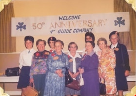
50th Anniversary 4th Guide Company
https://search.heritageburnaby.ca/link/museumdescription4949
- Repository
- Burnaby Village Museum
- Date
- Nov 3, 1976
- Collection/Fonds
- Burnaby Girl Guides fonds
- Description Level
- Item
- Physical Description
- 1 photograph : col. 9 x 12.5 cm
- Scope and Content
- Photograph of members of 4th Guide Company standing in front of a sign which reads "Welcome / 50th Anniversary / 4th Guide Company". Guiders in back row are identified from L to R as: Mrs. Dumka (Lt.), Mrs. Florence Underhill (Div. Comm.), Mrs. Kent (Dist. Comm), Mrs. Vivian E.S. Henderson (Area Co…
- Repository
- Burnaby Village Museum
- Collection/Fonds
- Burnaby Girl Guides fonds
- Description Level
- Item
- Physical Description
- 1 photograph : col. 9 x 12.5 cm
- Scope and Content
- Photograph of members of 4th Guide Company standing in front of a sign which reads "Welcome / 50th Anniversary / 4th Guide Company". Guiders in back row are identified from L to R as: Mrs. Dumka (Lt.), Mrs. Florence Underhill (Div. Comm.), Mrs. Kent (Dist. Comm), Mrs. Vivian E.S. Henderson (Area Comm.); Front row L to R: Mrs. Alice Thomas (Ellett), Mrs. Meta-Fay Miskell (Peden), Miss May Kelly, Miss Bessie Kelly, Mrs. Bristow (original guide captain).
- Other Title Information
- Title based on contents of photograph.
- Names
- Bristow, Dorothy
- Kent, Dorothy
- Kelly, May
- Kelly, Bessie
- Underhill, Florence
- Thomas, Alice Ellett
- Miskell, Meta Fay Peden
- Henderson, Vivian
- Girl Guides of Canada
- Accession Code
- BV015.35.285
- Access Restriction
- No restrictions
- Reproduction Restriction
- May be restricted by third party rights
- Date
- Nov 3, 1976
- Media Type
- Photograph
- Scan Resolution
- 600
- Scan Date
- 05/11/2018
- Notes
- Photograph is part of scrapbook BV015.35.166
Images

Burnaby Teachers
https://search.heritageburnaby.ca/link/archivedescription62933
- Repository
- City of Burnaby Archives
- Date
- [1990]
- Collection/Fonds
- Burnaby Historical Society fonds
- Description Level
- File
- Physical Description
- 1 file of textual records
- Scope and Content
- File consists of photocopied pages listing teachers on staff from 1987 to 1990. Teachers included in the file are from; Schou Education Cntr, Sec. Special Program, District Serv. - Kit, Educational Admin, Student Services, Community Education, 100 Prov. F. - Hearing, 100 Prov. F. - W.C.C., 100 Prov…
- Repository
- City of Burnaby Archives
- Date
- [1990]
- Collection/Fonds
- Burnaby Historical Society fonds
- Subseries
- Burnaby Retired Teachers subseries
- Physical Description
- 1 file of textual records
- Description Level
- File
- Record No.
- MSS103-025
- Access Restriction
- Open access
- Accession Number
- BHS2002-11
- Scope and Content
- File consists of photocopied pages listing teachers on staff from 1987 to 1990. Teachers included in the file are from; Schou Education Cntr, Sec. Special Program, District Serv. - Kit, Educational Admin, Student Services, Community Education, 100 Prov. F. - Hearing, 100 Prov. F. - W.C.C., 100 Prov. F. - Maples, 100 Prov. F. - Holly, 100 Prov. F. BCCC, Windsor Re-entry, Dist Student Serv, 100% Prov. F. (Sbd-Ch), Burnaby School Board, Sec Alternative Prog, WYDC School, Maples School, HYCC School, BYCC School and the Canada Way Education Centre [sic].
- Media Type
- Textual Record
- Notes
- Title on folder originally housing contents of this file read: "BURNABY TEACHERS / Septembers, 1987 to 1990 / Not on School Staff Lists"
Bylaw Number: 13863 - Zoning Bylaw 1965, Amendment Bylaw No. 11, 2018
https://search.heritageburnaby.ca/link/bylaw25099
- Repository
- Legislative Services
- Bylaw Number
- 13863
- Final Adoption
- 2018 May 14
- Format
- Bylaws - Adopted
- Collection/Fonds
- City Council and Office of the City Clerk fonds
- Repository
- Legislative Services
- Bylaw Number
- 13863
- Final Adoption
- 2018 May 14
- Format
- Bylaws - Adopted
- Collection/Fonds
- City Council and Office of the City Clerk fonds
Documents
Deed of Land Sale - fragment
https://search.heritageburnaby.ca/link/museumdescription10089
- Repository
- Burnaby Village Museum
- Date
- [1893]
- Collection/Fonds
- Love family fonds
- Description Level
- Item
- Physical Description
- 1 p. of textual records
- Scope and Content
- Item consists of the bottom portion of a Deed of Land Sale. It contains a hand written, legal description of property which reads: "Cumberland Road in Lot 25, G. 1, N.W. Dist the / same being distant 14.18 Chs. S. 63.30 (degrees) E, from / the Northeast corner of said Lot 25; thense S. 63.30 E....a…
- Repository
- Burnaby Village Museum
- Collection/Fonds
- Love family fonds
- Description Level
- Item
- Physical Description
- 1 p. of textual records
- Scope and Content
- Item consists of the bottom portion of a Deed of Land Sale. It contains a hand written, legal description of property which reads: "Cumberland Road in Lot 25, G. 1, N.W. Dist the / same being distant 14.18 Chs. S. 63.30 (degrees) E, from / the Northeast corner of said Lot 25; thense S. 63.30 E....and containing by estimaton ten (10) acres...".
- History
- See extensive history of Love Family and Love farmhouse located at Burnaby Village Museum.
- Accession Code
- BV012.31.21
- Access Restriction
- No restrictions
- Reproduction Restriction
- No known restrictions
- Date
- [1893]
- Media Type
- Textual Record
- Notes
- Title based on content of file
Girl guiding : a handbook for brownies, guides, rangers, and guiders
https://search.heritageburnaby.ca/link/museumlibrary6815
- Repository
- Burnaby Village Museum
- Collection
- Special Collection
- Material Type
- Book
- Accession Code
- BV015.35.8
- Call Number
- 369.4 BAD
- Edition
- Centenary ed.
- Place of Publication
- London
- Publisher
- C. Arthur Pearson
- Publication Date
- 1961
- Printer
- C. Tingling & Co.
- Physical Description
- 191 p. : ill. ; 20 cm.
- Inscription
- "Kathy McDonald 6507 Waltham Ave South Burnaby" [handwritten on page opposing front pastedown in blue ink] H.H. Company Windsor Dist. Jr. Leader" [handwritten and crossed out on page opposing front pastedown in blue ink] Sticker reading: "STOP! Be sure to consult your current edition of Policy Organization and Rules for Canadian Guide Tests. Stores Department. Canadian Girl Guides Association 548 King St. West, Toronto 2-B, Canada. Form 7-10M-10-57" [attached to page opposing front pastedown]
- Library Subject (LOC)
- Girls--Societies and clubs
- Handbooks, manuals, etc.
- Notes
- "Reprint of 1938 edition as last revised by Lord Baden-Powell himself -- 1961"--t.p. Includes index.
Letter re North Boundary of Lots 9 and 107, Group 1, New Westminster District
https://search.heritageburnaby.ca/link/museumdescription11148
- Repository
- Burnaby Village Museum
- Date
- 13 Dec. 1910
- Collection/Fonds
- Ronald G. Scobbie collection
- Description Level
- File
- Physical Description
- 2 p. of textual records
- Scope and Content
- File consists of a handwritten letter dated December 13th 1910, from the "CORPORATION OF LAND SURVEYORS / OF THE PROVINCE OF BRITISH COLUMBIA...". the letter is addressed to "To. Albert J. Hill, Esq." "B.C.L.S." with the title "W.N. Draper -v- Albert J. Hill / RE - NORTH BOUNDARY OF LOTS 9 & 107. …
- Repository
- Burnaby Village Museum
- Collection/Fonds
- Ronald G. Scobbie collection
- Description Level
- File
- Physical Description
- 2 p. of textual records
- Scope and Content
- File consists of a handwritten letter dated December 13th 1910, from the "CORPORATION OF LAND SURVEYORS / OF THE PROVINCE OF BRITISH COLUMBIA...". the letter is addressed to "To. Albert J. Hill, Esq." "B.C.L.S." with the title "W.N. Draper -v- Albert J. Hill / RE - NORTH BOUNDARY OF LOTS 9 & 107. NEW WESTMINSTER DIST."The letter is signed "A. Roberts" "Secretary Treasurer & Registrar"
- Accession Code
- BV003.83.27
- Access Restriction
- No restrictions
- Reproduction Restriction
- No known restrictions
- Date
- 13 Dec. 1910
- Media Type
- Textual Record
- Notes
- Title based on contents of item
- Note in red crayon on verso of letter reads: "001607"
postcard
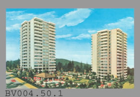
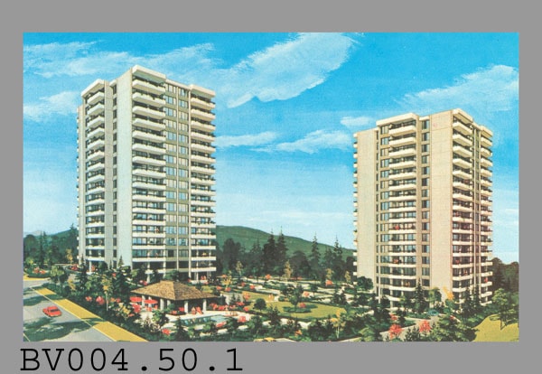
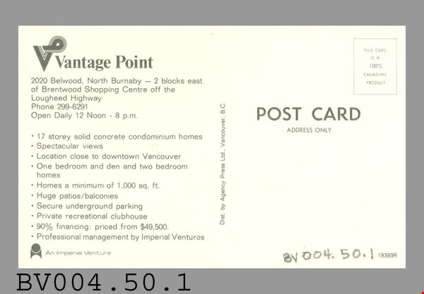
https://search.heritageburnaby.ca/link/museumartifact47195
- Repository
- Burnaby Village Museum
- Accession Code
- BV004.50.1
- Description
- Postcard: advertisement for "Vantage Point," a two high-rise development; coloured rendering; horizontal; glossy; shows two multi-storey buildings, landscaping, smaller building by pool, blue sky with clouds; on reverse in black "Vantage Point", logo, "2020 Belwood, North Burnaby -- 2 blocks east of Brentwood Shopping Centre off the Lougheed Highway" "Phone 299-6291" "Open Daily 12 Noon - 8 p.m."; 10 bullet points follow, about the property; at bottom, "An Imperial Venture", logo; up centre of card, "Dist. by Agency Press Ltd., Vancouver, B.C."; at right, "POST CARD" "ADDRESS ONLY"; outling of rectangle at upper right, "THIS CARD IS A 100% CANADIAN PRODUCT"; at lower right, "19393R"; slight wear on corners; c.1970s?; unused
- Classification
- Written Communication T&E - - Writing Media
- Object Term
- Postcard
- Marks/Labels
- Vantage Point / 2020 Belwood, North Burnaby / Brentwood Shopping Centre / Lougheed Highway
- Country Made
- Canada
- Province Made
- British Columbia
- Site/City Made
- Vancouver
- Title
- Vantage Point 19393R
- Subjects
- Documentary Artifacts
- Documentary Artifacts - Postcards
- Buildings
- Buildings - Residential
- Buildings - Residential - Apartments
Images
The practice of pharmacy : a treatise on the modes of making and dispensing official, unofficial, and extemporaneous preparations, with descriptions of medicinal substances, their properties, uses, and doses; intended as a hand-book for pharmacists and physicians and a text-book for students.
https://search.heritageburnaby.ca/link/museumlibrary247
- Repository
- Burnaby Village Museum
- Collection
- Special Collection
- Material Type
- Book
- Accession Code
- HV971.163.24
- Call Number
- 615.4 REM 1888
- Place of Publication
- Philidelphia
- Publisher
- J. B. Lippincott Company
- Publication Date
- 1888
- c1885
- Physical Description
- 1080 p. : ill. ; 25 cm.
- Inscription
- inside front cover: illustrated, printed nameplate "Incorruptible Hill Norfolk Eng." "Egerton Boyd Hill" small paper label, blue and white, designed to look like a book: "Williamson & Co S King St West Toronto" inside front page: "E B Hill [handwritten script in ink] O.C.P." "Toronto Ont" inside back page: "98" [handwritten in pencil] "137.7 DIST" "801"
- Library Subject (LOC)
- Pharmacy
- Medicine
- Handbooks, manuals, etc.
- Notes
- Includes index.
- "With nearly five hundred illustrations."
- Author's given name and dates: Remington, Joseph P. (Joseph Price), 1847-1918.
sales brochure
https://search.heritageburnaby.ca/link/museumartifact80118
- Repository
- Burnaby Village Museum
- Accession Code
- BV008.19.18
- Description
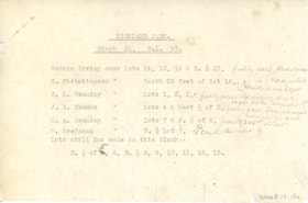
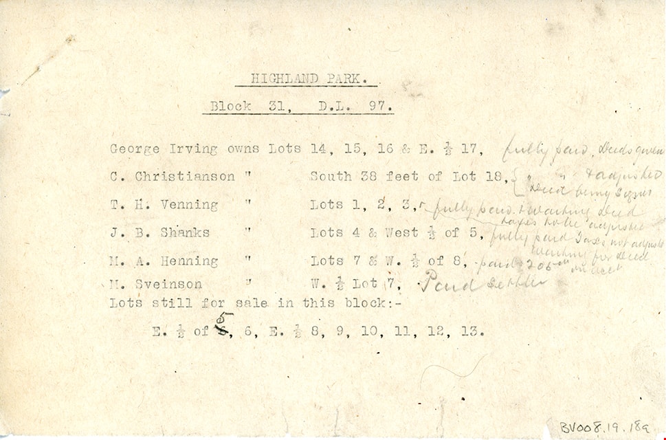
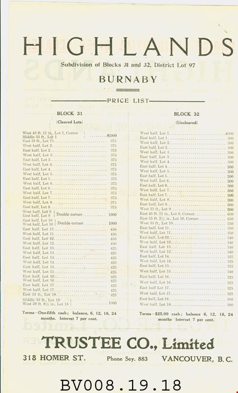
- Land sales brochure, cream paper, black and red print; "WHY TO BUY IN HIGHLANDS" "CHOICE RESIDENTIAL SITES CLEARED" "SUBDIVISION AND PRICE LIST OF" "BLOCKS 31 and 32. DISTRICT LOT 97, situated at the JUNCTION OF THE NEW CUT=OFF ON THE B.C. ELECTRIC TRAM LINE TO NEW WESTMINSTER"; "KEY MAP" of DL97 showing subdivisions of L.25, 26, 31, 32, 33, Vancouver and New Westminster Rd., Buller Rd., B.C.E.R. line, with Royal Oak, Highland Park, and Gillie [sic] Stations, cut-off, Roberts Rd., White Rd.; Group I New Westminster Dist.; terms; "TRUSTEE CO., Limited" "318 HOMER ST. VANCOUVER" "Phone Seymour 883"; description "... magnificent view..."; price list for subdivisions of Bl.31 (cleared) and 32 (uncleared); and "Plan Shewing..." with enlarged view, focusing on lots at White Rd., Buller Rd., roads and allowances; names and resubdivisions drawn on this plan with red ink, pencilled directions and additions; this area was known as the Highlands or Highland Park; 17" x 14"; folded in half to 8.5" X 14"; with an 8.5" x 5.25" piece of note paper pinned to brochure, typed listing of properties and buyers for block 31; notes as to payment and deeds given are handwritten in pencil and match names handwritten on plan itself: George Irving, C. Christianson, T.H. Venning, J.B. Shanks, M.A. Henning, M. Sveinson; soiled; small tears at edges
- Object History
- The Highland Park sub-division in District Lot 97, was in part a real estate development by the company owned by the Thomson family. James and Melville P. Thomson, owned and operated "Thomson Bros." They had extensive property interests in Vancouver and Burnaby and owned and operated a book selling and stationery business in Vancouver.
- Category
- 08. Communication Artifacts
- Classification
- Advertising Media
- Object Term
- Brochure
- Marks/Labels
- "HIGHLANDS / Subdividion of Blocks 31 and 32, District Lot 97 / BURNABY / PRICE LIST / . . . . / TRUSTEE CO., Limited / 318 HOMER ST. Phone Sey. 883 VANCOUVER, B.C.
- Colour
- Cream
- Country Made
- Canada
- Province Made
- British Columbia
- Site/City Made
- Vancouver
- Title
- Subdivision and Price List of Blocks 31 and 32 District Lot 97 New Westminster District
- Historic Neighbourhood
- Highland Park (Historic Neighbourhood)
Images


Steps to Girl Guiding : an abridged edition of the official handbook
https://search.heritageburnaby.ca/link/museumlibrary6837
- Repository
- Burnaby Village Museum
- Collection
- Special Collection
- Material Type
- Book
- Accession Code
- BV015.35.30
- Call Number
- 369.4 BAD
- Place of Publication
- London
- Publisher
- C. Arthur Pearson
- Publication Date
- c1920
- 1923
- Physical Description
- 64 p. : ill. ; 19 cm.
- Inscription
- "Lakeview Dist. Bby. Royal Area (imp. Div)" [handwritten in black ink on first page] "Ireland & Allen Books & Stationary 649 Granville St Vancouver, B. C." [stamped on cover]
- Library Subject (LOC)
- Girls--Societies and clubs
- Handbooks, manuals, etc.

Subdivision plans in New Westminster District Group 1 – Burnaby, Vancouver and map - Canada Department of Mines
https://search.heritageburnaby.ca/link/museumdescription6994
- Repository
- Burnaby Village Museum
- Date
- 1890-1909
- Collection/Fonds
- Burnaby Village Museum Map collection
- Description Level
- File
- Physical Description
- 1 plan : graphite on paper + 2 plans : black ink on paper + 1 map : col. on paper mounted on 2 sides of cardboard 76 x 102 cm
- Scope and Content
- Item consists of a large board with one New Westminster District subdivision plan mounted on one side and two New Westminster District subdivision plans and one colour map mounted on the other side. Side A: 1. "Plan / of Subdivision of / Blocks 2, 3, 4, 5, 6 / Lot 77 / Group 1 / New Westminster D…
- Repository
- Burnaby Village Museum
- Collection/Fonds
- Burnaby Village Museum Map collection
- Description Level
- File
- Physical Description
- 1 plan : graphite on paper + 2 plans : black ink on paper + 1 map : col. on paper mounted on 2 sides of cardboard 76 x 102 cm
- Material Details
- Scales 1:720 and 1:1200 and 1:.00001578
- Scope and Content
- Item consists of a large board with one New Westminster District subdivision plan mounted on one side and two New Westminster District subdivision plans and one colour map mounted on the other side. Side A: 1. "Plan / of Subdivision of / Blocks 2, 3, 4, 5, 6 / Lot 77 / Group 1 / New Westminster District / BC. / Scale 100 feet = 1 inch", "Deposited 8th day / of April 1890 / Mowileg [sic] / Dist. Regt". Plan is drawn in graphite with annotations: "AB_Parts_lettered_are_lots_in / the_different_subdivisions" / "Owners: / James E. Hall / P.S.Cabilan [sic] by his attorney Joseph Hall / Joseph Hall / Eliza J. Shannon / John Harrison"; "This plan is correct and is prepared under the / provisions of the Land Registry Act" ; signed by: "Gordon Herman & Burwell / Dominion & Provincial Land Surveryors / Vancouver March 19th/90" . Plan is initialed by: "RB" [sic] (in blue pencil crayon) and measures: 99.5 x 65 cm (Geographic location: Burnaby) Side B: 1. Map titled "Canada / Department of Mines / Geological Survey Branch" / "Hon.W Templeton, Minister / A.P. Low, Deputy Minister / R.W. Brock, Acting Director", Vol. XXXI, Plate I / Compiled under the direction of / James White, F.R.G.S. Geographer /Dep. of Interior". Note above map reads: "To illustrate Mr. James Barrowman's report as Delegate at the Excursion - meeting of the Canadian Mining Institute", "The instiitution of Mining Engineers / Transactions 1908 - 1909", "The Mining Institute of Scotland / Transactions 1908-1909". Map identifies minerals and includes a Legend and Scale: 100 miles = 1 inch 2. "Plan / of Subdivision of / Lot 4 / of Subdivision of / Lot 87. Gr. 1 / New Westminster District / Scale 60' = 1in." Plan is initialed by: "RB" [sic] along with a note "also Board / 48" (in blue pencil crayon) (Geographic location: Burnaby) 3. Plan of "Lot 335 / G. 1" west of Boundary Road and north of River Road - Vancouver. (Geographic location: Vancouver)
- Publisher
- The Mining Institute of Scotland
- Geographic Access
- Vancouver
- Accession Code
- HV977.93.25
- Access Restriction
- No restrictions
- Reproduction Restriction
- No known restrictions
- Date
- 1890-1909
- Media Type
- Cartographic Material
- Scan Resolution
- 300
- Scale
- 72
- Notes
- Title based on contents of file
- Scale is measured in feet and miles.
- The term "Lot" often refers to "District Lot"
Images

