Narrow Results By
Subject
- Academic Disciplines 3
- Accidents 10
- Accidents - Automobile Accidents 26
- Accidents - Train Accidents 8
- Adornment - Jewelry 3
- Adornment - Lapel Pins 1
- Advertising Medium 10
- Advertising Medium - Signs and Signboards 168
- Aerial Photographs 127
- Agricultural Tools and Equipment 16
- Agricultural Tools and Equipment - Cultivators 1
- Agricultural Tools and Equipment - Gardening Equipment 10

Capitol Hill Community Hall
https://search.heritageburnaby.ca/link/landmark563
- Repository
- Burnaby Heritage Planning
- Description
- Public building.
- Associated Dates
- 1948
- Street View URL
- Google Maps Street View
- Repository
- Burnaby Heritage Planning
- Geographic Access
- Howard Avenue
- Associated Dates
- 1948
- Description
- Public building.
- Heritage Value
- The Capitol Hill Community Hall was designed by local architect Harold Cullerne (1890-1976). After Cullerne returned from service during the First World War, he joined J.H. Bowman in a partnership that lasted from 1919 to 1934. After Bowman retired in 1934, Cullerne practiced on his own, continuing to work on schools and institutional buildings, such as the Art Deco Hollywood Theatre in Vancouver. In 1944, Cullerne designed a community hall for Capitol Hill; the scheme was delayed, and redesigned before it was finally built after the end of the Second World War. A simple front gabled roof hall structure, this hall is a monument to community spirit, erected by community members on a volunteer basis, and used for community events for over half a century. The hall replaced two earlier structures, both destroyed by fire, that had served the same purpose.
- Locality
- Capitol Hill
- Historic Neighbourhood
- Capitol Hill (Historic Neighbourhood)
- Planning Study Area
- Capitol Hill Area
- Architect
- Harold Cullerne
- Ownership
- Public (local)
- Street Address
- 361 Howard Avenue
- Street View URL
- Google Maps Street View
Images


Duncan & Margaret McGregor Estate 'Glen-Lyon' Mansion
https://search.heritageburnaby.ca/link/landmark518
- Repository
- Burnaby Heritage Planning
- Description
- Overlooking the rich farmland of the Fraser River floodplain, 'Glen-Lyon' is an Edwardian era rural estate, with a tall, two and one-half storey plus basement wood-frame mansion, set in a pastoral and formal landscape with an associated barn and early log pond, located near a ravine and forested ar…
- Associated Dates
- 1902
- Formal Recognition
- Heritage Designation, Community Heritage Register
- Street View URL
- Google Maps Street View
- Repository
- Burnaby Heritage Planning
- Geographic Access
- Marine Drive
- Associated Dates
- 1902
- Formal Recognition
- Heritage Designation, Community Heritage Register
- Enactment Type
- Bylaw No. 12183
- Enactment Date
- 11/12/2006
- Description
- Overlooking the rich farmland of the Fraser River floodplain, 'Glen-Lyon' is an Edwardian era rural estate, with a tall, two and one-half storey plus basement wood-frame mansion, set in a pastoral and formal landscape with an associated barn and early log pond, located near a ravine and forested area adjacent to Marine Drive in South Burnaby.
- Heritage Value
- ‘Glen-Lyon’ is valued as an excellent example of a privately-owned Edwardian era country estate built at the turn of the nineteenth century. The property retains significant heritage features including the Edwardian era mansion with rustic Arts and Crafts features, and elements of a working agricultural landscape. The property was originally the Royal City Mills logging camp, and in 1900 was purchased by Duncan Campbell McGregor (1853-1929) and Margaret Jane McGregor (1875-1960), who named their estate ‘Glen-Lyon’ after Duncan McGregor’s birthplace in Perthshire, Scotland. The McGregors were active in municipal affairs and social activities, and played a significant role in the early development of Burnaby. Duncan McGregor served as a city councillor from 1909 to 1912 and was elected reeve of Burnaby in 1913. Margaret McGregor was instrumental in the formation and fundraising activities of the Victoria Order of Nurses in Burnaby. Additionally, the site is historically significant for its association with early social welfare and correctional reform. The estate was sold in 1926 to an inter-denominational religious organization called the Home of the Friendless, which used it as their B.C. headquarters. The organization was charged with several cases of abuse and neglect in 1937, after which a Royal Commission was formed that led to new legislation to regulate and license all private welfare institutions. 'Glen-Lyon' was sold to the provincial government, and was dedicated in 1939 by the Lt.-Gov. E.W. Hamber for use as the New Haven Borstal Home for Boys and Youthful Offenders (later renamed the New Haven Correction Centre). The Borstal movement originated in England in the late nineteenth century, as an alternative to sending young offenders and runaways to prisons by providing reformatories that focused on discipline and vocational skill. This site’s role as the first North American institution devoted to the Borstal School philosophy was historic, and influenced corrections programs across Canada. The site retains significant features from its development in 1939 as the Borstal School, including a large gambrel-roofed barn designed by Chief Provincial Architect Henry Whittaker of the Department of Public Works that is the only remaining structure of its kind in Burnaby. Between 1941 and 1945 the mansion housed the Provincial School for the Deaf and Blind when the Borstal School was closed temporarily as a war measure during the Second World War.
- Defining Elements
- Key elements that define the heritage character of 'Glen-Lyon' Mansion include its: - location on a sloping site with expansive southern exposure, adjacent to Marine Drive - residential form, scale and massing of the house as exemplified by its two and one-half storey height, above-ground basement and rectangular plan - Arts and Crafts elements of the house such as its stone foundation, multi-gabled roof line with steep central hipped roof, symmetrical cross-gables, side shed dormers, bellcast upper walls sheathed in cedar shingles and lower walls sheathed in narrow clapboard - original exterior features of the house such as the full width front verandah with square columns, central staircase on the southern elevation, original doors and stained glass windows; and the irregular fenestration such as double-hung 1-over-1 wooden-sash windows, bay windows, and projecting windows in the gable ends - original interior features of the house such as the U-shaped main stair designed around two symmetrically placed Ionic columns, and interior trim on the main floor including boxed beams and fireplaces - gambrel-roofed barn with roof vent with finial, sliding hay loft and access doors, small multi-pane windows, and lapped wooden siding - associated landscape features such as the original garden plantings with some exotic and many native specimen trees; the original log pond and its concrete Marine Drive causeway and culvert; rockeries and a rose garden
- Historic Neighbourhood
- Fraser Arm (Historic Neighbourhood)
- Planning Study Area
- Big Bend Area
- Architect
- Henry Whittaker
- Function
- Primary Historic--Estate
- Community
- Burnaby
- Cadastral Identifier
- 003-004-661
- Boundaries
- 'Glen-Lyon' is comprised of a single residential lot located at 4250 Marine Drive, Burnaby.
- Area
- 230873.18
- Contributing Resource
- Building
- Ownership
- Private
- Names
- McGregor, Duncan C. (1853-1929)
- Whittaker, Henry
- Home of the Friendless
- Borstal School
- New Haven Correction Centre
- Subjects
- Buildings - Heritage
- Buildings - Residential - Houses
- Buildings - Public - Detention Facilities
- Buildings - Residential
- Street Address
- 4250 Marine Drive
- Street View URL
- Google Maps Street View
Images


Duncan & Margaret McGregor Estate 'Glen-Lyon' New Haven Barn
https://search.heritageburnaby.ca/link/landmark852
- Repository
- Burnaby Heritage Planning
- Description
- Designed in a vernacular architectural style, the New Haven Barn is a large gambrel-roofed barn located on the Edwardian era McGregor Estate 'Glen-Lyon,' overlooking the rich farmland of the Fraser River floodplain and near a ravine and forested area adjacent to Marine Drive in South Burnaby.
- Associated Dates
- 1939
- Formal Recognition
- Heritage Designation, Community Heritage Register
- Other Names
- Home of the Friendless, New Haven Borstal Home for Boys and Youthful Offenders, New Haven Correction Centre
- Street View URL
- Google Maps Street View
- Repository
- Burnaby Heritage Planning
- Other Names
- Home of the Friendless, New Haven Borstal Home for Boys and Youthful Offenders, New Haven Correction Centre
- Geographic Access
- Marine Drive
- Associated Dates
- 1939
- Formal Recognition
- Heritage Designation, Community Heritage Register
- Enactment Type
- Bylaw No. 12183
- Enactment Date
- 11/12/2006
- Description
- Designed in a vernacular architectural style, the New Haven Barn is a large gambrel-roofed barn located on the Edwardian era McGregor Estate 'Glen-Lyon,' overlooking the rich farmland of the Fraser River floodplain and near a ravine and forested area adjacent to Marine Drive in South Burnaby.
- Heritage Value
- The site is historically significant for its association with early social welfare and correctional reform. The estate was sold in 1926 to an inter-denominational religious organization called the Home of the Friendless, which used it as their B.C. headquarters. The organization was charged with several cases of abuse and neglect in 1937, after which a Royal Commission was formed that led to new legislation to regulate and license all private welfare institutions. 'Glen-Lyon' was sold to the provincial government, and was dedicated in 1939 by the Lt.-Gov. E.W. Hamber for use as the New Haven Borstal Home for Boys and Youthful Offenders (later renamed the New Haven Correction Centre). The Borstal movement originated in England in the late nineteenth century, as an alternative to sending young offenders and runaways to prisons by providing reformatories that focused on discipline and vocational skill. This site’s role as the first North American institution devoted to the Borstal School philosophy was historic, and influenced corrections programs across Canada. The New Haven Barn is a significant feature from its development in 1939 as the Borstal School, designed by Chief Provincial Architect Henry Whittaker of the Department of Public Works, and is the only remaining structure of its kind in Burnaby.
- Defining Elements
- Key elements that define the heritage character of the New Haven Barn include its: - gambrel-roofed barn with roof vent with finial, sliding hay loft and access doors, small multi-pane windows, and lapped wooden siding
- Historic Neighbourhood
- Fraser Arm (Historic Neighbourhood)
- Planning Study Area
- Big Bend Area
- Architect
- Henry Whittaker
- Function
- Primary Historic--Estate
- Community
- Burnaby
- Cadastral Identifier
- 003-004-661
- Boundaries
- 'Glen-Lyon' is comprised of a single residential lot located at 4250 Marine Drive, Burnaby.
- Area
- 230873.18
- Contributing Resource
- Building
- Ownership
- Private
- Names
- Whittaker, George
- New Haven Borstal Home for Boys and Youthful Offenders
- New Haven Correction Centre
- Borstal School
- Street Address
- 4250 Marine Drive
- Street View URL
- Google Maps Street View
Images


H.T. Ceperley Estate 'Fairacres' Garage & Stables
https://search.heritageburnaby.ca/link/landmark530
- Repository
- Burnaby Heritage Planning
- Description
- Designed in the British Arts and Crafts style, the ‘Fairacres’ Garage and Stables is a two-storey wood frame building located on the 'Fairacres' estate, situated to the north of the Chauffeur's Cottage; at the south end of the structure is a single vehicle garage and to the north are several stable…
- Associated Dates
- 1911
- Formal Recognition
- Heritage Designation, Community Heritage Register
- Street View URL
- Google Maps Street View
- Repository
- Burnaby Heritage Planning
- Geographic Access
- Deer Lake Avenue
- Associated Dates
- 1911
- Formal Recognition
- Heritage Designation, Community Heritage Register
- Enactment Type
- Bylaw No. 9807
- Enactment Date
- 23/11/1992
- Description
- Designed in the British Arts and Crafts style, the ‘Fairacres’ Garage and Stables is a two-storey wood frame building located on the 'Fairacres' estate, situated to the north of the Chauffeur's Cottage; at the south end of the structure is a single vehicle garage and to the north are several stables for carriage, riding, and draught horses, a coach house, and tack room; the upper floor was originally a hay loft.
- Heritage Value
- The outbuildings at 'Fairacres' are a rare surviving architecturally designed ensemble of agricultural structures that exist in complementary harmony with the main estate house. Architect Robert Mackay Fripp (1858-1917) was retained by the Ceperleys to design several original outbuildings on their estate at the same time as the main house was constructed. The Garage and Stables building is important as a record of its era when transportation modes were in transition and the horse-drawn carriage, while still in use, was giving way to the automobile. The relative spatial arrangements within the building are a valuable indication of the economy of space associated with the automobile, as compared to the horse. The extent of the stabling arrangements signifies not only the use of carriage horses but also the continued reliance on draught horses in farming activities in this era. As well, it is an indication of the fashionable nature of equestrianism for wealthy families during this time. The building is important as a demonstration of the aesthetics of the Ceperley family in having an architect-designed outbuilding and obtaining craftsmanship and materials of the highest quality for each structure on their estate.
- Defining Elements
- Key elements that define the heritage character of the 'Fairacres' Garage and Stables include its: - location within easy reach of the main house and in close proximity to the Chauffeur's Cottage - floor plan with the garage at one end, close to the Chauffeur's Cottage, and stables and equine facilities at the other - variety and complexity of the roofline, including gable wall dormers, gable-on-hip roof ends, and half-hip extensions - Arts and Crafts architectural features of the exterior such as the shingle wall cladding articulated with a chevron-patterned course of shingles at the first floor level; casement windows; and deep eaves with additional purlins to support the overhang - original stable doors with hand-made forged-iron door hardware - multi-paned wooden-sash windows, some retaining original wire glass
- Locality
- Deer Lake Park
- Historic Neighbourhood
- Burnaby Lake (Historic Neighbourhood)
- Planning Study Area
- Douglas-Gilpin Area
- Architect
- Robert Mackay Fripp
- Function
- Primary Historic--Outbuilding
- Community
- Burnaby
- Cadastral Identifier
- P.I.D. No. 004-493-311 Legal Description: Block 3 Except: Part subdivided by Plan 26865, District Lot 79, Group 1, New Westminster District, Plan 536
- Boundaries
- ‘Fairacres’ is comprised of a single municipally-owned property located at 6344 Deer Lake Avenue, Burnaby.
- Area
- 17,065.00
- Contributing Resource
- Building
- Landscape Feature
- Ownership
- Public (local)
- Other Collection
- Burnaby Historical Society, Community Archives: Ceperley Photograph Album
- Documentation
- Heritage Site Files: PC77000 20. City of Burnaby Planning and Building Department, 4949 Canada Way, Burnaby, B.C., V5G 1M2
- Street Address
- 6344 Deer Lake Avenue
- Street View URL
- Google Maps Street View
Images


Administration Building New Haven Borstal
https://search.heritageburnaby.ca/link/archivedescription93663
- Repository
- City of Burnaby Archives
- Date
- January 15, 1978
- Collection/Fonds
- Burnaby Public Library Contemporary Visual Archive Project
- Description Level
- Item
- Physical Description
- 1 photograph : b&w ; 12.5 x 17.5 cm
- Scope and Content
- Photograph of the exterior of the administration building at the New Haven Borstal Institute. The photograph is taken from across the lawn, facing northwest. A man is looking into the window of the building on the left.
- Repository
- City of Burnaby Archives
- Date
- January 15, 1978
- Collection/Fonds
- Burnaby Public Library Contemporary Visual Archive Project
- Physical Description
- 1 photograph : b&w ; 12.5 x 17.5 cm
- Description Level
- Item
- Record No.
- 556-620
- Access Restriction
- No restrictions
- Reproduction Restriction
- Reproduce for fair dealing purposes only
- Accession Number
- 2017-57
- Scope and Content
- Photograph of the exterior of the administration building at the New Haven Borstal Institute. The photograph is taken from across the lawn, facing northwest. A man is looking into the window of the building on the left.
- Subjects
- Buildings - Public - Detention Facilities
- Buildings - Schools
- Buildings - Heritage
- Government - Provincial Government
- Media Type
- Photograph
- Photographer
- Surridge, Jack
- Notes
- Title taken from project information form
- Accompanied by a project information form and 1 photograph (b&w negative ; 9.5 x 12.5 cm)
- BPL no. 69
- Street Address
- 4520 Marine Drive
- Historic Neighbourhood
- Fraser Arm (Historic Neighbourhood)
- Planning Study Area
- Big Bend Area
Images

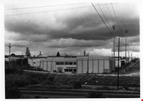
Alaska Street Library Warehouse
https://search.heritageburnaby.ca/link/archivedescription93676
- Repository
- City of Burnaby Archives
- Date
- June 4, 1978
- Collection/Fonds
- Burnaby Public Library Contemporary Visual Archive Project
- Description Level
- Item
- Physical Description
- 1 photograph : b&w ; 12.5 x 17.5 cm
- Scope and Content
- Photograph of the exterior of the Burnaby Public Library administration office and storage warehouse, located at 4455 Alaska Street, off Willlingdon Avenue. The photograph is taken from across the street, facing east.
- Repository
- City of Burnaby Archives
- Date
- June 4, 1978
- Collection/Fonds
- Burnaby Public Library Contemporary Visual Archive Project
- Physical Description
- 1 photograph : b&w ; 12.5 x 17.5 cm
- Description Level
- Item
- Record No.
- 556-633
- Access Restriction
- No restrictions
- Reproduction Restriction
- Reproduce for fair dealing purposes only
- Accession Number
- 2017-57
- Scope and Content
- Photograph of the exterior of the Burnaby Public Library administration office and storage warehouse, located at 4455 Alaska Street, off Willlingdon Avenue. The photograph is taken from across the street, facing east.
- Names
- Burnaby Public Library
- Media Type
- Photograph
- Photographer
- Surridge, Jack
- Notes
- Title taken from project information form
- Accompanied by a project information form and 1 photograph (b&w negative ; 9.5 x 12.5 cm)
- BPL no. 82
- Street Address
- 4455 Alaska Street
- Historic Neighbourhood
- Broadview (Historic Neighbourhood)
- Planning Study Area
- West Central Valley Area
Images
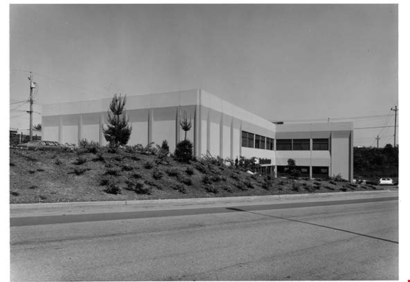
Alaska Street Library Warehouse
https://search.heritageburnaby.ca/link/archivedescription93677
- Repository
- City of Burnaby Archives
- Date
- June 4, 1978
- Collection/Fonds
- Burnaby Public Library Contemporary Visual Archive Project
- Description Level
- Item
- Physical Description
- 1 photograph : b&w ; 17.5 x 12.5 cm
- Scope and Content
- Photograph of the exterior of the Burnaby Public Library administration office and storage warehouse, located at 4455 Alaska Street, off Willlingdon Avenue. The photograph is taken from across the street, facing north.
- Repository
- City of Burnaby Archives
- Date
- June 4, 1978
- Collection/Fonds
- Burnaby Public Library Contemporary Visual Archive Project
- Physical Description
- 1 photograph : b&w ; 17.5 x 12.5 cm
- Description Level
- Item
- Record No.
- 556-634
- Access Restriction
- No restrictions
- Reproduction Restriction
- Reproduce for fair dealing purposes only
- Accession Number
- 2017-57
- Scope and Content
- Photograph of the exterior of the Burnaby Public Library administration office and storage warehouse, located at 4455 Alaska Street, off Willlingdon Avenue. The photograph is taken from across the street, facing north.
- Names
- Burnaby Public Library
- Media Type
- Photograph
- Photographer
- Surridge, Jack
- Notes
- Title taken from project information form
- Accompanied by a project information form and 1 photograph (b&w negative ; 12.5 x 9.5 cm)
- BPL no. 83
- Street Address
- 4455 Alaska Street
- Historic Neighbourhood
- Broadview (Historic Neighbourhood)
- Planning Study Area
- West Central Valley Area
Images

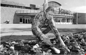
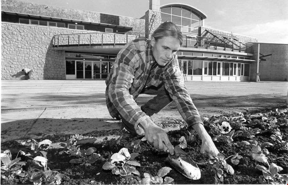
Andreas Katzenneier
https://search.heritageburnaby.ca/link/archivedescription78663
- Repository
- City of Burnaby Archives
- Date
- October 22, 1995
- Collection/Fonds
- Burnaby NewsLeader photograph collection
- Description Level
- Item
- Physical Description
- 1 photograph : b&w ; 15.5 x 24 cm
- Scope and Content
- Photograph of Andreas Katzenneier planting petunias in front of the Shadbolt Centre for the Arts for the official opening on November 18, 1995.
- Repository
- City of Burnaby Archives
- Date
- October 22, 1995
- Collection/Fonds
- Burnaby NewsLeader photograph collection
- Physical Description
- 1 photograph : b&w ; 15.5 x 24 cm
- Description Level
- Item
- Record No.
- 535-0024
- Access Restriction
- No restrictions
- Reproduction Restriction
- No reproduction permitted
- Accession Number
- 2012-11
- Scope and Content
- Photograph of Andreas Katzenneier planting petunias in front of the Shadbolt Centre for the Arts for the official opening on November 18, 1995.
- Names
- Katzenneier, Andreas
- Media Type
- Photograph
- Photographer
- Bartel, Mario
- Notes
- Title based on contents of photograph
- Note in blue ink on recto of photograph reads: "Mario Bby 2890 92% Bby 1"
- Trim marks and/or reproduction instructions on recto (scan is cropped)
- Geographic Access
- Burnaby Lake
Images
![Barns at Oakalla, [195-] (date of original), copied 1991 thumbnail](/media/hpo/_Data/_Archives_Images/_Unrestricted/370/370-706.jpg?width=280)
Barns at Oakalla
https://search.heritageburnaby.ca/link/archivedescription38119
- Repository
- City of Burnaby Archives
- Date
- [195-] (date of original), copied 1991
- Collection/Fonds
- Burnaby Historical Society fonds
- Description Level
- Item
- Physical Description
- 1 photograph : b&w ; 2.8 x 4.1 cm print on contact sheet 20.1 x 26.5 cm
- Scope and Content
- Photograph of the exterior of horse and cattle barns at Oakalla Prison Farm.
- Repository
- City of Burnaby Archives
- Date
- [195-] (date of original), copied 1991
- Collection/Fonds
- Burnaby Historical Society fonds
- Subseries
- Burnaby Image Bank subseries
- Physical Description
- 1 photograph : b&w ; 2.8 x 4.1 cm print on contact sheet 20.1 x 26.5 cm
- Description Level
- Item
- Record No.
- 370-706
- Access Restriction
- No restrictions
- Reproduction Restriction
- Reproduce for fair dealing purposes only
- Accession Number
- BHS1999-03
- Scope and Content
- Photograph of the exterior of horse and cattle barns at Oakalla Prison Farm.
- Subjects
- Buildings - Agricultural - Barns
- Agriculture - Farms
- Buildings - Public - Detention Facilities
- Names
- Oakalla Prison Farm
- Media Type
- Photograph
- Notes
- Title based on contents of photograph
- 1 b&w copy negative accompanying
- Negative has a pink cast
- Geographic Access
- Oakmount Crescent
- Street Address
- 5220 Oakmount Crescent
- Historic Neighbourhood
- Burnaby Lake (Historic Neighbourhood)
- Planning Study Area
- Oakalla Area
Images
![Barns at Oakalla, [195-] (date of original), copied 1991 thumbnail](/media/hpo/_Data/_Archives_Images/_Unrestricted/370/370-706.jpg)
![Blacksmith Shop at Oakalla, [1914] (date of original), copied 1991 thumbnail](/media/hpo/_Data/_Archives_Images/_Unrestricted/370/370-721.jpg?width=280)
Blacksmith Shop at Oakalla
https://search.heritageburnaby.ca/link/archivedescription38134
- Repository
- City of Burnaby Archives
- Date
- [1914] (date of original), copied 1991
- Collection/Fonds
- Burnaby Historical Society fonds
- Description Level
- Item
- Physical Description
- 1 photograph : b&w ; 4.5 x 2.7 cm print on contact sheet 19.8 x 26.2 cm
- Scope and Content
- Photograph of the exterior of the first blacksmith shop at Oakalla Prison Farm.
- Repository
- City of Burnaby Archives
- Date
- [1914] (date of original), copied 1991
- Collection/Fonds
- Burnaby Historical Society fonds
- Subseries
- Burnaby Image Bank subseries
- Physical Description
- 1 photograph : b&w ; 4.5 x 2.7 cm print on contact sheet 19.8 x 26.2 cm
- Description Level
- Item
- Record No.
- 370-721
- Access Restriction
- No restrictions
- Reproduction Restriction
- No known restrictions
- Accession Number
- BHS1999-03
- Scope and Content
- Photograph of the exterior of the first blacksmith shop at Oakalla Prison Farm.
- Names
- Oakalla Prison Farm
- Media Type
- Photograph
- Notes
- Title based on contents of photograph
- 1 b&w copy negative accompanying
- Negative has a pink cast
- Geographic Access
- Oakmount Crescent
- Street Address
- 5220 Oakmount Crescent
- Historic Neighbourhood
- Burnaby Lake (Historic Neighbourhood)
- Planning Study Area
- Oakalla Area
Images
![Blacksmith Shop at Oakalla, [1914] (date of original), copied 1991 thumbnail](/media/hpo/_Data/_Archives_Images/_Unrestricted/370/370-721.jpg)
![Boat-building/carpentry shop at Oakalla, [195-] (date of original), copied 1991 thumbnail](/media/hpo/_Data/_Archives_Images/_Unrestricted/370/370-723.jpg?width=280)
Boat-building/carpentry shop at Oakalla
https://search.heritageburnaby.ca/link/archivedescription38136
- Repository
- City of Burnaby Archives
- Date
- [195-] (date of original), copied 1991
- Collection/Fonds
- Burnaby Historical Society fonds
- Description Level
- Item
- Physical Description
- 1 photograph : b&w ; 3.2 x 5.1 cm print on contact sheet 19.8 x 26.2 cm
- Scope and Content
- Photograph of the interior of the boat-building/carpentry shop at Oakalla Prison Farm. A man is standing inside a partially completed boat, while two other men look on.
- Repository
- City of Burnaby Archives
- Date
- [195-] (date of original), copied 1991
- Collection/Fonds
- Burnaby Historical Society fonds
- Subseries
- Burnaby Image Bank subseries
- Physical Description
- 1 photograph : b&w ; 3.2 x 5.1 cm print on contact sheet 19.8 x 26.2 cm
- Description Level
- Item
- Record No.
- 370-723
- Access Restriction
- No restrictions
- Reproduction Restriction
- Reproduce for fair dealing purposes only
- Accession Number
- BHS1999-03
- Scope and Content
- Photograph of the interior of the boat-building/carpentry shop at Oakalla Prison Farm. A man is standing inside a partially completed boat, while two other men look on.
- Names
- Oakalla Prison Farm
- Media Type
- Photograph
- Notes
- Title based on contents of photograph
- 1 b&w copy negative accompanying
- Negative has a pink cast
- Geographic Access
- Oakmount Crescent
- Street Address
- 5220 Oakmount Crescent
- Historic Neighbourhood
- Burnaby Lake (Historic Neighbourhood)
- Planning Study Area
- Oakalla Area
Images
![Boat-building/carpentry shop at Oakalla, [195-] (date of original), copied 1991 thumbnail](/media/hpo/_Data/_Archives_Images/_Unrestricted/370/370-723.jpg)
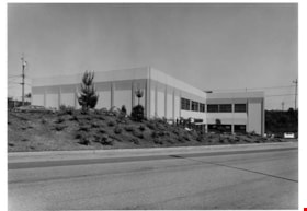
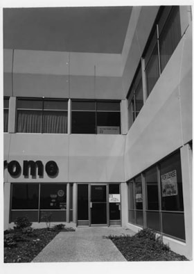
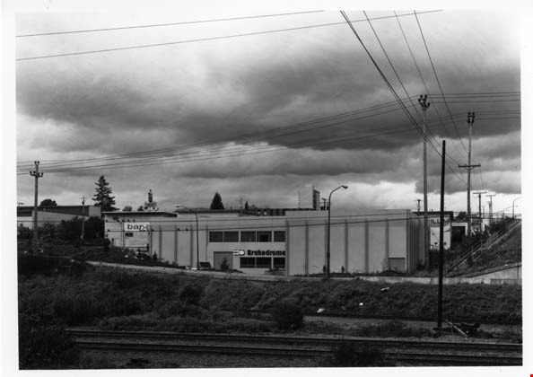
B.P.L. Administration Office
https://search.heritageburnaby.ca/link/archivedescription93624
- Repository
- City of Burnaby Archives
- Date
- October 23, 1977
- Collection/Fonds
- Burnaby Public Library Contemporary Visual Archive Project
- Description Level
- Item
- Physical Description
- 1 photograph : b&w ; 12.5 x 17.5 cm
- Scope and Content
- Photograph of the exterior of the Burnaby Public Library Administration Office and storage, located at 4455 Alaska Street, off Willingdon Avenue. Signs for Brakedrome and other warehouses are also visible. The photograph is taken facing north, across the railway tracks.
- Repository
- City of Burnaby Archives
- Date
- October 23, 1977
- Collection/Fonds
- Burnaby Public Library Contemporary Visual Archive Project
- Physical Description
- 1 photograph : b&w ; 12.5 x 17.5 cm
- Description Level
- Item
- Record No.
- 556-581
- Access Restriction
- No restrictions
- Reproduction Restriction
- Reproduce for fair dealing purposes only
- Accession Number
- 2017-57
- Scope and Content
- Photograph of the exterior of the Burnaby Public Library Administration Office and storage, located at 4455 Alaska Street, off Willingdon Avenue. Signs for Brakedrome and other warehouses are also visible. The photograph is taken facing north, across the railway tracks.
- Names
- Burnaby Public Library
- Media Type
- Photograph
- Photographer
- Surridge, Jack
- Notes
- Title taken from project information form
- Accompanied by a project information form and 1 photograph (b&w negative ; 9.5 x 12.5 cm)
- BPL no. 28
- Street Address
- 4455 Alaska Street
- Historic Neighbourhood
- Broadview (Historic Neighbourhood)
- Planning Study Area
- West Central Valley Area
Images

Burnaby Lake Sign (Nature House)
https://search.heritageburnaby.ca/link/archivedescription93629
- Repository
- City of Burnaby Archives
- Date
- October 22, 1977
- Collection/Fonds
- Burnaby Public Library Contemporary Visual Archive Project
- Description Level
- Item
- Physical Description
- 1 photograph : b&w ; 12.5 x 17.5 cm
- Scope and Content
- Photograph of the sign welcoming the public to the Nature House and Burnaby Lake. The sign depicts a map of Burnaby Lake and points of interest, including the rowing complex, pool, ice rink, and Old Mill Site. A smaller sign shows the address of 4519 Piper and a small footbridge is in the backgroun…
- Repository
- City of Burnaby Archives
- Date
- October 22, 1977
- Collection/Fonds
- Burnaby Public Library Contemporary Visual Archive Project
- Physical Description
- 1 photograph : b&w ; 12.5 x 17.5 cm
- Description Level
- Item
- Record No.
- 556-586
- Access Restriction
- No restrictions
- Reproduction Restriction
- Reproduce for fair dealing purposes only
- Accession Number
- 2017-57
- Scope and Content
- Photograph of the sign welcoming the public to the Nature House and Burnaby Lake. The sign depicts a map of Burnaby Lake and points of interest, including the rowing complex, pool, ice rink, and Old Mill Site. A smaller sign shows the address of 4519 Piper and a small footbridge is in the background. The photograph is taken facing southwest.
- Media Type
- Photograph
- Photographer
- Surridge, Jack
- Notes
- Title taken from project information form
- Accompanied by a project information form and 1 photograph (b&w negative ; 9.5 x 12.5 cm)
- BPL no. 35
- Geographic Access
- Burnaby Lake Regional Nature Park
- Street Address
- 4519 Piper Avenue
- Historic Neighbourhood
- Lozells (Historic Neighbourhood)
- Planning Study Area
- Burnaby Lake Area
Images


Burnaby Mountain Parking Lot & Restaurant
https://search.heritageburnaby.ca/link/archivedescription93706
- Repository
- City of Burnaby Archives
- Date
- February 15, 1978
- Collection/Fonds
- Burnaby Public Library Contemporary Visual Archive Project
- Description Level
- Item
- Physical Description
- 1 photograph : b&w ; 12.5 x 17.5 cm
- Scope and Content
- Photograph of the view of the mountains and park from a hill on Burnaby Mountain Park. The photograph is taken facing north. The photograph shows the parking lot and the Burnaby Mountain Centennial Pavilion.
- Repository
- City of Burnaby Archives
- Date
- February 15, 1978
- Collection/Fonds
- Burnaby Public Library Contemporary Visual Archive Project
- Physical Description
- 1 photograph : b&w ; 12.5 x 17.5 cm
- Description Level
- Item
- Record No.
- 556-663
- Access Restriction
- No restrictions
- Reproduction Restriction
- Reproduce for fair dealing purposes only
- Accession Number
- 2017-57
- Scope and Content
- Photograph of the view of the mountains and park from a hill on Burnaby Mountain Park. The photograph is taken facing north. The photograph shows the parking lot and the Burnaby Mountain Centennial Pavilion.
- Subjects
- Buildings - Commercial - Restaurants
- Buildings - Civic
- Buildings - Recreational
- Geographic Features - Automobile Parking Lots
- Geographic Features - Parks
- Names
- Burnaby Mountain Park
- Media Type
- Photograph
- Photographer
- Surridge, Jack
- Notes
- Title taken from project information form
- Accompanied by a project information form and 1 photograph (b&w negative ; 9.5 x 12.5 cm)
- BPL no. 111
- Geographic Access
- Burnaby Lake Regional Nature Park
- Burnaby Mountain Conservation Area
- Street Address
- 100 Centennial Way
- Planning Study Area
- Burnaby Mountain Area
Images


Burnaby Mountain Park Pavilion Building
https://search.heritageburnaby.ca/link/archivedescription93642
- Repository
- City of Burnaby Archives
- Date
- November 19, 1977
- Collection/Fonds
- Burnaby Public Library Contemporary Visual Archive Project
- Description Level
- Item
- Physical Description
- 1 photograph : b&w ; 12.5 x 17.5 cm
- Scope and Content
- Photograph of the Burnaby Centennial Pavilion in Burnaby Mountain Park. The pavilion was built in 1958 for the British Columbia Centenary and became Horizons Restaurant in 1986 and may have housed The Owl and the Oarsman Restaurant at this time. Two individuals are standing on the deck and looking …
- Repository
- City of Burnaby Archives
- Date
- November 19, 1977
- Collection/Fonds
- Burnaby Public Library Contemporary Visual Archive Project
- Physical Description
- 1 photograph : b&w ; 12.5 x 17.5 cm
- Description Level
- Item
- Record No.
- 556-599
- Access Restriction
- No restrictions
- Reproduction Restriction
- Reproduce for fair dealing purposes only
- Accession Number
- 2017-57
- Scope and Content
- Photograph of the Burnaby Centennial Pavilion in Burnaby Mountain Park. The pavilion was built in 1958 for the British Columbia Centenary and became Horizons Restaurant in 1986 and may have housed The Owl and the Oarsman Restaurant at this time. Two individuals are standing on the deck and looking toward the mountains. The photograph is taken from across the lawn, facing north of northwest.
- Media Type
- Photograph
- Photographer
- McGillivray, Don
- Notes
- Title taken from project information form
- Accompanied by a project information form and 1 photograph (b&w negative ; 9.5 x 12.5 cm)
- BPL no. 49
- Geographic Access
- Burnaby Mountain Conservation Area
- Street Address
- 100 Centennial Way
- Planning Study Area
- Burnaby Mountain Area
Images

![Calf Barn at Oakalla, [195-] (date of original), copied 1991 thumbnail](/media/hpo/_Data/_Archives_Images/_Unrestricted/370/370-718.jpg?width=280)
Calf Barn at Oakalla
https://search.heritageburnaby.ca/link/archivedescription38131
- Repository
- City of Burnaby Archives
- Date
- [195-] (date of original), copied 1991
- Collection/Fonds
- Burnaby Historical Society fonds
- Description Level
- Item
- Physical Description
- 1 photograph : b&w ; 3.0 x 4.3 cm print on contact sheet 19.8 x 26.2 cm
- Scope and Content
- Photograph of the exterior of the calf barn at Oakalla Prison Farm.
- Repository
- City of Burnaby Archives
- Date
- [195-] (date of original), copied 1991
- Collection/Fonds
- Burnaby Historical Society fonds
- Subseries
- Burnaby Image Bank subseries
- Physical Description
- 1 photograph : b&w ; 3.0 x 4.3 cm print on contact sheet 19.8 x 26.2 cm
- Description Level
- Item
- Record No.
- 370-718
- Access Restriction
- No restrictions
- Reproduction Restriction
- Reproduce for fair dealing purposes only
- Accession Number
- BHS1999-03
- Scope and Content
- Photograph of the exterior of the calf barn at Oakalla Prison Farm.
- Subjects
- Buildings - Agricultural - Barns
- Agriculture - Farms
- Buildings - Public - Detention Facilities
- Names
- Oakalla Prison Farm
- Media Type
- Photograph
- Notes
- Title based on contents of photograph
- 1 b&w copy negative accompanying
- Negative has a pink cast
- Geographic Access
- Oakmount Crescent
- Street Address
- 5220 Oakmount Crescent
- Historic Neighbourhood
- Burnaby Lake (Historic Neighbourhood)
- Planning Study Area
- Oakalla Area
Images
![Calf Barn at Oakalla, [195-] (date of original), copied 1991 thumbnail](/media/hpo/_Data/_Archives_Images/_Unrestricted/370/370-718.jpg)
![Carpenter Shop at Oakalla, [195-] (date of original), copied 1991 thumbnail](/media/hpo/_Data/_Archives_Images/_Unrestricted/370/370-707.jpg?width=280)
Carpenter Shop at Oakalla
https://search.heritageburnaby.ca/link/archivedescription38120
- Repository
- City of Burnaby Archives
- Date
- [195-] (date of original), copied 1991
- Collection/Fonds
- Burnaby Historical Society fonds
- Description Level
- Item
- Physical Description
- 1 photograph : b&w ; 2.9 x 4.1 cm print on contact sheet 20.1 x 26.5 cm
- Scope and Content
- Photograph of the exterior of the carpenter shop at Oakalla Prison Farm.
- Repository
- City of Burnaby Archives
- Date
- [195-] (date of original), copied 1991
- Collection/Fonds
- Burnaby Historical Society fonds
- Subseries
- Burnaby Image Bank subseries
- Physical Description
- 1 photograph : b&w ; 2.9 x 4.1 cm print on contact sheet 20.1 x 26.5 cm
- Description Level
- Item
- Record No.
- 370-707
- Access Restriction
- No restrictions
- Reproduction Restriction
- Reproduce for fair dealing purposes only
- Accession Number
- BHS1999-03
- Scope and Content
- Photograph of the exterior of the carpenter shop at Oakalla Prison Farm.
- Names
- Oakalla Prison Farm
- Media Type
- Photograph
- Notes
- Title based on contents of photograph
- 1 b&w copy negative accompanying
- Negative has a pink cast
- Geographic Access
- Oakmount Crescent
- Street Address
- 5220 Oakmount Crescent
- Historic Neighbourhood
- Burnaby Lake (Historic Neighbourhood)
- Planning Study Area
- Oakalla Area
Images
![Carpenter Shop at Oakalla, [195-] (date of original), copied 1991 thumbnail](/media/hpo/_Data/_Archives_Images/_Unrestricted/370/370-707.jpg)
![Community police station, [1999] thumbnail](/media/hpo/_Data/_Archives_Images/_Unrestricted/535/535-3333.jpg?width=280)
Community police station
https://search.heritageburnaby.ca/link/archivedescription98266
- Repository
- City of Burnaby Archives
- Date
- [1999]
- Collection/Fonds
- Burnaby NewsLeader photograph collection
- Description Level
- Item
- Physical Description
- 1 photograph (tiff) : b&w
- Scope and Content
- Photograph of an unidentified Burnaby RCMP officer, dressed in uniform and standing inside of an office.
- Repository
- City of Burnaby Archives
- Date
- [1999]
- Collection/Fonds
- Burnaby NewsLeader photograph collection
- Physical Description
- 1 photograph (tiff) : b&w
- Description Level
- Item
- Record No.
- 535-3333
- Access Restriction
- No restrictions
- Reproduction Restriction
- No restrictions
- Accession Number
- 2018-12
- Scope and Content
- Photograph of an unidentified Burnaby RCMP officer, dressed in uniform and standing inside of an office.
- Media Type
- Photograph
- Notes
- Title based on original file name
- Collected by editorial for use in a September 1999 issue of the Burnaby NewsLeader
Images
![Community police station, [1999] thumbnail](/media/hpo/_Data/_Archives_Images/_Unrestricted/535/535-3333.jpg)
![Community police station, [1999] thumbnail](/media/hpo/_Data/_Archives_Images/_Unrestricted/535/535-3352.jpg?width=280)
Community police station
https://search.heritageburnaby.ca/link/archivedescription98342
- Repository
- City of Burnaby Archives
- Date
- [1999]
- Collection/Fonds
- Burnaby NewsLeader photograph collection
- Description Level
- Item
- Physical Description
- 1 photograph (tiff) : col.
- Scope and Content
- Photograph of an unidentified Burnaby RCMP officer speaking on a phone in one of Burnaby's community police stations.
- Repository
- City of Burnaby Archives
- Date
- [1999]
- Collection/Fonds
- Burnaby NewsLeader photograph collection
- Physical Description
- 1 photograph (tiff) : col.
- Description Level
- Item
- Record No.
- 535-3352
- Access Restriction
- No restrictions
- Reproduction Restriction
- No restrictions
- Accession Number
- 2018-12
- Scope and Content
- Photograph of an unidentified Burnaby RCMP officer speaking on a phone in one of Burnaby's community police stations.
- Media Type
- Photograph
- Notes
- Title based on original file name
- Collected by editorial for use in an October 1999 issue of the Burnaby NewsLeader
Images
![Community police station, [1999] thumbnail](/media/hpo/_Data/_Archives_Images/_Unrestricted/535/535-3352.jpg)
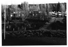
Cowan Centre & Parking Lot
https://search.heritageburnaby.ca/link/archivedescription93669
- Repository
- City of Burnaby Archives
- Date
- January 18, 1978
- Collection/Fonds
- Burnaby Public Library Contemporary Visual Archive Project
- Description Level
- Item
- Physical Description
- 1 photograph : b&w ; 12.5 x 17.5 cm
- Scope and Content
- Photograph of the exterior of the James Cowan Centre (now the James Cowan Theatre at the Shadbolt Centre for the Arts) and the nearby parking lot and gardens. The photograph is taken looking down from a high point, facing east.
- Repository
- City of Burnaby Archives
- Date
- January 18, 1978
- Collection/Fonds
- Burnaby Public Library Contemporary Visual Archive Project
- Physical Description
- 1 photograph : b&w ; 12.5 x 17.5 cm
- Description Level
- Item
- Record No.
- 556-626
- Access Restriction
- No restrictions
- Reproduction Restriction
- Reproduce for fair dealing purposes only
- Accession Number
- 2017-57
- Scope and Content
- Photograph of the exterior of the James Cowan Centre (now the James Cowan Theatre at the Shadbolt Centre for the Arts) and the nearby parking lot and gardens. The photograph is taken looking down from a high point, facing east.
- Names
- James Cowan Theatre
- Media Type
- Photograph
- Photographer
- Surridge, Jack
- Notes
- Title taken from project information form
- Accompanied by a project information form and 1 photograph (b&w negative ; 9.5 x 12.5 cm)
- BPL no. 75
- Street Address
- 6450 Deer Lake Avenue
- Historic Neighbourhood
- Burnaby Lake (Historic Neighbourhood)
- Planning Study Area
- Douglas-Gilpin Area
Images
