Narrow Results By
Subject
- Academic Disciplines 3
- Accidents 15
- Accidents - Automobile Accidents 31
- Accidents - Train Accidents 23
- Adminstrative Groups - Committees 4
- Adornment 83
- Adornment - Jewelry
- Adornment - Lapel Pins 84
- Advertising Medium 104
- Advertising Medium - Business Cards 17
- Advertising Medium - Flyer 38
- Advertising Medium - Poster 18

Duncan & Margaret McGregor Estate 'Glen-Lyon' New Haven Barn
https://search.heritageburnaby.ca/link/landmark852
- Repository
- Burnaby Heritage Planning
- Description
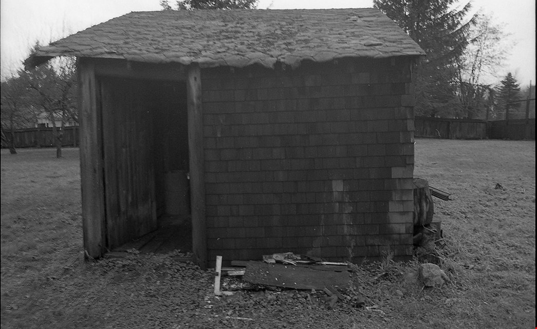
- Designed in a vernacular architectural style, the New Haven Barn is a large gambrel-roofed barn located on the Edwardian era McGregor Estate 'Glen-Lyon,' overlooking the rich farmland of the Fraser River floodplain and near a ravine and forested area adjacent to Marine Drive in South Burnaby.
- Associated Dates
- 1939
- Formal Recognition
- Heritage Designation, Community Heritage Register
- Other Names
- Home of the Friendless, New Haven Borstal Home for Boys and Youthful Offenders, New Haven Correction Centre
- Street View URL
- Google Maps Street View
- Repository
- Burnaby Heritage Planning
- Other Names
- Home of the Friendless, New Haven Borstal Home for Boys and Youthful Offenders, New Haven Correction Centre
- Geographic Access
- Marine Drive
- Associated Dates
- 1939
- Formal Recognition
- Heritage Designation, Community Heritage Register
- Enactment Type
- Bylaw No. 12183
- Enactment Date
- 11/12/2006
- Description
- Designed in a vernacular architectural style, the New Haven Barn is a large gambrel-roofed barn located on the Edwardian era McGregor Estate 'Glen-Lyon,' overlooking the rich farmland of the Fraser River floodplain and near a ravine and forested area adjacent to Marine Drive in South Burnaby.
- Heritage Value
- The site is historically significant for its association with early social welfare and correctional reform. The estate was sold in 1926 to an inter-denominational religious organization called the Home of the Friendless, which used it as their B.C. headquarters. The organization was charged with several cases of abuse and neglect in 1937, after which a Royal Commission was formed that led to new legislation to regulate and license all private welfare institutions. 'Glen-Lyon' was sold to the provincial government, and was dedicated in 1939 by the Lt.-Gov. E.W. Hamber for use as the New Haven Borstal Home for Boys and Youthful Offenders (later renamed the New Haven Correction Centre). The Borstal movement originated in England in the late nineteenth century, as an alternative to sending young offenders and runaways to prisons by providing reformatories that focused on discipline and vocational skill. This site’s role as the first North American institution devoted to the Borstal School philosophy was historic, and influenced corrections programs across Canada. The New Haven Barn is a significant feature from its development in 1939 as the Borstal School, designed by Chief Provincial Architect Henry Whittaker of the Department of Public Works, and is the only remaining structure of its kind in Burnaby.
- Defining Elements
- Key elements that define the heritage character of the New Haven Barn include its: - gambrel-roofed barn with roof vent with finial, sliding hay loft and access doors, small multi-pane windows, and lapped wooden siding
- Historic Neighbourhood
- Fraser Arm (Historic Neighbourhood)
- Planning Study Area
- Big Bend Area
- Architect
- Henry Whittaker
- Function
- Primary Historic--Estate
- Community
- Burnaby
- Cadastral Identifier
- 003-004-661
- Boundaries
- 'Glen-Lyon' is comprised of a single residential lot located at 4250 Marine Drive, Burnaby.
- Area
- 230873.18
- Contributing Resource
- Building
- Ownership
- Private
- Names
- Whittaker, George
- New Haven Borstal Home for Boys and Youthful Offenders
- New Haven Correction Centre
- Borstal School
- Street Address
- 4250 Marine Drive
- Street View URL
- Google Maps Street View
Images


H.T. Ceperley Estate 'Fairacres' Greenhouse Foundation Wall
https://search.heritageburnaby.ca/link/landmark862
- Repository
- Burnaby Heritage Planning
- Description
- The original rubble stone walls that formed the foundation for a greenhouses adjacent to the Steam Plant Building provided heat to several greenhouses on the estate propoerty. The Root House, which is to the north of the Greenhouse Foundation Wall, provided storage for the farm operation.
- Associated Dates
- 1908
- Formal Recognition
- Heritage Designation, Community Heritage Register
- Repository
- Burnaby Heritage Planning
- Geographic Access
- Deer Lake Avenue
- Associated Dates
- 1908
- Formal Recognition
- Heritage Designation, Community Heritage Register
- Enactment Type
- Bylaw No. 140665
- Enactment Date
- 23/11/1992
- Description
- The original rubble stone walls that formed the foundation for a greenhouses adjacent to the Steam Plant Building provided heat to several greenhouses on the estate propoerty. The Root House, which is to the north of the Greenhouse Foundation Wall, provided storage for the farm operation.
- Heritage Value
- The outbuildings at 'Fairacres' are a rare surviving architecturally-designed ensemble of agricultural structures that exist in complementary harmony with the main estate house. Architect Robert Mackay Fripp (1858-1917), an outspoken advocate of Arts and Crafts design, was retained by the Ceperleys to design several original outbuildings on their estate, which was designed as a country estate with a working farm that included over 10 acres of productive berry and vegetable fields, with a large kitchen garden, a root house to store food, an orchard, and greenhouses heated by steam. The agricultural potential of the Deer Lake area made it one of the first parts of the municipality to attract settlement. In 1909, the Ceperleys built three large greenhouses heated by an adjacent steam plant (Fairacres Steam Plant). The greenhouses featured granite foundation walls, including this one which remains intact. The Ceperleys employed a large staff to manage the estate's agricultural production, including Chinese farm labourers. Produce was grown for use at the estate, and for sale at local markets. Agricultural use of the estate continued when a Catholic order of Benedictine monks purchased the estate as part of the Priory of St. Joseph and the Seminary of Christ the King, and continued to farm the land until 1953.
- Defining Elements
- Key elements that define the heritage character of the ‘Fairacres’ Steam Plant Building include its: - overall spatial arrangement of the Greenhouse Foundation Wall in relation to the Steam Plant Building and the Root House - original rubble stone walls reflecting the Arts and Crafts design aesthetic of the estate buildings.
- Locality
- Deer Lake Park
- Historic Neighbourhood
- Burnaby Lake (Historic Neighbourhood)
- Planning Study Area
- Douglas-Gilpin Area
- Architect
- Robert Mackay Fripp
- Function
- Primary Historic--Outbuilding
- Community
- Burnaby
- Cadastral Identifier
- P.I.D. No. 004-493-311 Legal Description: Block 3 Except: Part subdivided by Plan 26865, District Lot 79, Group 1, New Westminster District, Plan 536
- Boundaries
- ‘Fairacres’ is comprised of a single municipally-owned property located at 6344 Deer Lake Avenue, Burnaby.
- Area
- 17,065.00
- Contributing Resource
- Landscape Feature
- Remains
- Ownership
- Public (local)
- Other Collection
- Burnaby Historical Society, Community Archives: Ceperley Photograph Album
- Documentation
- Heritage Site Files: PC77000 20. City of Burnaby Planning and Building Department, 4949 Canada Way, Burnaby, B.C., V5G 1M2
- Street Address
- 6344 Deer Lake Avenue
Images


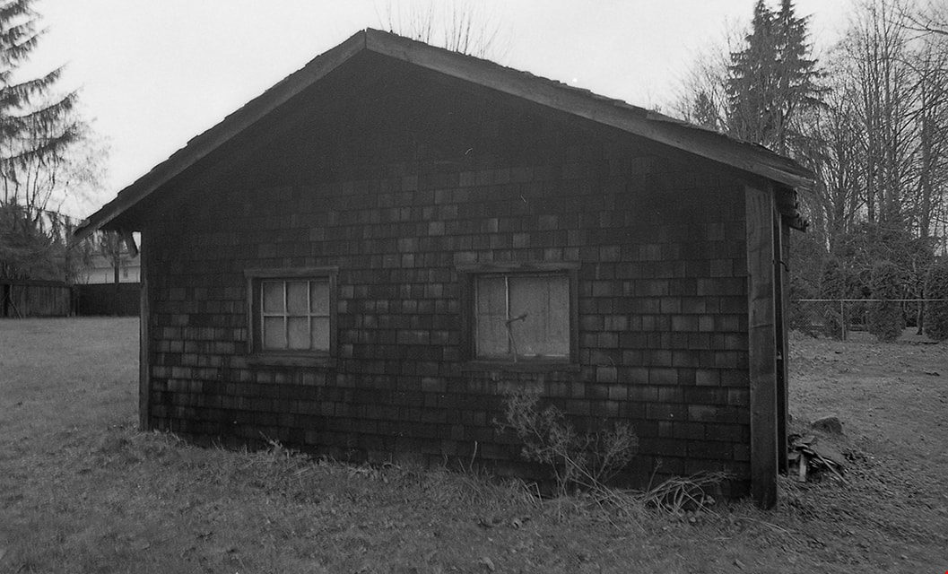
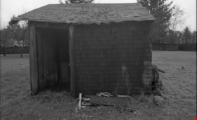
H.T. Ceperley Estate 'Fairacres' Root House
https://search.heritageburnaby.ca/link/landmark527
- Repository
- Burnaby Heritage Planning
- Description
- The ‘Fairacres’ Root House is a long, low one-storey masonry building, measuring 4.6 metres by 9.1 metres, with massively buttressed concrete walls and foundations. Built into sloping ground adjacent to the location of the former greenhouses, the surviving orchard and the kitchen entrance of the ma…
- Associated Dates
- 1908
- Formal Recognition
- Heritage Designation, Community Heritage Register
- Repository
- Burnaby Heritage Planning
- Geographic Access
- Deer Lake Avenue
- Associated Dates
- 1908
- Formal Recognition
- Heritage Designation, Community Heritage Register
- Enactment Type
- Bylaw No. 9807
- Enactment Date
- 23/11/1992
- Description
- The ‘Fairacres’ Root House is a long, low one-storey masonry building, measuring 4.6 metres by 9.1 metres, with massively buttressed concrete walls and foundations. Built into sloping ground adjacent to the location of the former greenhouses, the surviving orchard and the kitchen entrance of the main house, 'Fairacres,' this functional structure was used as a frost-free store for fruit and vegetables for the family's use.
- Heritage Value
- The outbuildings at 'Fairacres' are a rare surviving architecturally-designed ensemble of agricultural structures that exist in complementary harmony with the main estate house. Architect Robert Mackay Fripp (1858-1917), an outspoken advocate of Arts and Crafts design, was retained by the Ceperleys to design several original outbuildings on their estate. The Root House is important as a rare surviving, and exceptionally large, example of this building type in the Vancouver region. Unusual in the fact that an architect designed a building of such modest aspirations, it is also remarkable in its method of construction. The use of concrete as a structural material is one of the earliest in the region and extraordinary for its use on such a modest vernacular outbuilding; root cellars were typically built of loose stone. Built in 1908, the Root House was significantly altered in the 1960s and restored to its original design in 2000. The building is significant as an indicator of the market gardening activity in the area around Deer Lake and of the country-house self-sufficiency practiced by the Ceperley family. The Root House illustrates the cultural, aesthetic, and lifestyle values of the Ceperleys in constructing such a large building for storing their own produce.
- Defining Elements
- The outbuildings at 'Fairacres' are a rare surviving architecturally-designed ensemble of agricultural structures that exist in complementary harmony with the main estate house. Architect Robert Mackay Fripp (1858-1917), an outspoken advocate of Arts and Crafts design, was retained by the Ceperleys to design several original outbuildings on their estate. The Root House is important as a rare surviving, and exceptionally large, example of this building type in the Vancouver region. Unusual in the fact that an architect designed a building of such modest aspirations, it is also remarkable in its method of construction. The use of concrete as a structural material is one of the earliest in the region and extraordinary for its use on such a modest vernacular outbuilding; root cellars were typically built of loose stone. Built in 1908, the Root House was significantly altered in the 1960s and restored to its original design in 2000. The building is significant as an indicator of the market gardening activity in the area around Deer Lake and of the country-house self-sufficiency practiced by the Ceperley family. The Root House illustrates the cultural, aesthetic, and lifestyle values of the Ceperleys in constructing such a large building for storing their own produce.
- Locality
- Deer Lake Park
- Historic Neighbourhood
- Burnaby Lake (Historic Neighbourhood)
- Planning Study Area
- Douglas-Gilpin Area
- Architect
- Robert Mackay Fripp
- Function
- Primary Historic--Outbuilding
- Secondary Historic--Food Storage
- Community
- Burnaby
- Cadastral Identifier
- P.I.D. No. 004-493-311 Legal Description: Block 3 Except: Part subdivided by Plan 26865, District Lot 79, Group 1, New Westminster District, Plan 536
- Boundaries
- ‘Fairacres’ is comprised of a single municipally-owned property located at 6344 Deer Lake Avenue, Burnaby.
- Area
- 17,065.00
- Contributing Resource
- Building
- Landscape Feature
- Ownership
- Public (local)
- Other Collection
- Burnaby Historical Society, Community Archives: Ceperley Photograph Album
- Documentation
- Heritage Site Files: PC77000 20. City of Burnaby Planning and Building Department, 4949 Canada Way, Burnaby, B.C., V5G 1M2
- Street Address
- 6344 Deer Lake Avenue
Images


H.T. Ceperley Estate 'Fairacres' Steam Plant Building
https://search.heritageburnaby.ca/link/landmark528
- Repository
- Burnaby Heritage Planning
- Description
- Designed in the British Arts and Crafts style, the ‘Fairacres’ Steam Plant Buiding is a single-storey wood frame building with a gabled roof that originally housed the apparatus for climate control in the greenhouses, formerly located to its north. The original rubble stone walls that formed the fo…
- Associated Dates
- 1908
- Formal Recognition
- Heritage Designation, Community Heritage Register
- Repository
- Burnaby Heritage Planning
- Geographic Access
- Deer Lake Avenue
- Associated Dates
- 1908
- Formal Recognition
- Heritage Designation, Community Heritage Register
- Enactment Type
- Bylaw No. 9807
- Enactment Date
- 23/11/1992
- Description
- Designed in the British Arts and Crafts style, the ‘Fairacres’ Steam Plant Buiding is a single-storey wood frame building with a gabled roof that originally housed the apparatus for climate control in the greenhouses, formerly located to its north. The original rubble stone walls that formed the foundation for the greenhouses stand adjacent. The Steam Plant Building stands as a pendant to the Root House, which is to the north of the former greenhouses.
- Heritage Value
- The outbuildings at 'Fairacres' are a rare surviving architecturally-designed ensemble of agricultural structures that exist in complementary harmony with the main estate house. Architect Robert Mackay Fripp (1858-1917), an outspoken advocate of Arts and Crafts design, was retained by the Ceperleys to design several original outbuildings on their estate. The Ceperleys operated 'Fairacres' with staff, a farm manager and workers, including Chinese, to grow produce for themselves and for sale at local markets. The Steam Plant Building illustrates the market gardening activity of the area around Deer Lake and its importance to the Ceperley family, which valued a year-round supply of fresh fruit and vegetables for the kitchen and flowers for the house. It also illustrates the cultural and aesthetic values of the Ceperleys in retaining an architect to design a functional outbuilding using an accepted and contemporary architectural style. Built in 1908, the Steam Plant Building was significantly altered in the 1960s and restored to its original design in 2000.
- Defining Elements
- Key elements that define the heritage character of the ‘Fairacres’ Steam Plant Building include its: - overall spatial arrangement of the Steam Plant Building in relation to the former greenhouses and the Root House - side gable roof with cedar shingle cladding. - tall brick chimney indicitive of the building's original function. - distinctive Arts and Crafts architectural features such as the shingle wall cladding with decorative shingling under window sills, deep eaves, and pebble-dashed concrete foundation walls - six-paned wooden-sash casement windows - simple functional interior features - rubble stone walls that formed the foundation for the greenhouses
- Locality
- Deer Lake Park
- Historic Neighbourhood
- Burnaby Lake (Historic Neighbourhood)
- Planning Study Area
- Douglas-Gilpin Area
- Architect
- Robert Mackay Fripp
- Function
- Primary Historic--Outbuilding
- Community
- Burnaby
- Cadastral Identifier
- P.I.D. No. 004-493-311 Legal Description: Block 3 Except: Part subdivided by Plan 26865, District Lot 79, Group 1, New Westminster District, Plan 536
- Boundaries
- ‘Fairacres’ is comprised of a single municipally-owned property located at 6344 Deer Lake Avenue, Burnaby.
- Area
- 17,065.00
- Contributing Resource
- Building
- Landscape Feature
- Ownership
- Public (local)
- Other Collection
- Burnaby Historical Society, Community Archives: Ceperley Photograph Album
- Documentation
- Heritage Site Files: PC77000 20. City of Burnaby Planning and Building Department, 4949 Canada Way, Burnaby, B.C., V5G 1M2
- Street Address
- 6344 Deer Lake Avenue
Images

Barn book
https://search.heritageburnaby.ca/link/museumlibrary4912
- Repository
- Burnaby Village Museum
- Author
- Beatty Bros Limited
- Publication Date
- c1931
- Call Number
- 631 BEA
- Repository
- Burnaby Village Museum
- Collection
- Special Collection
- Material Type
- Book
- Accession Code
- BV991.45.136
- Call Number
- 631 BEA
- Author
- Beatty Bros Limited
- Place of Publication
- London
- Publisher
- Beatty Bros., Ltd.
- Publication Date
- c1931
- Physical Description
- 334 p. : ill. : 25 cm.
- Library Subject (LOC)
- Barns
- Farm buildings
- Dairying
- Stables
- Catalogs
- Subjects
- Buildings
- Buildings - Agricultural
- Buildings - Agricultural - Barns
- Agriculture
- Agriculture - Dairy
- Names
- Oakalla Prison Farm
- Object History
- Salvaged from Oakalla Prison site in October 1991
- Notes
- Includes index.
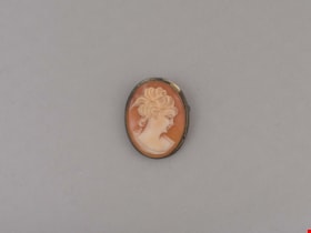
brooch
https://search.heritageburnaby.ca/link/museumartifact81107
- Repository
- Burnaby Village Museum
- Accession Code
- BV009.18.15
- Description
- Female portrait cameo carved in red background. Mounted in a metal ring with a pin back and a loop at the top. May be worn as a pin or on a chain.
- Marks/Labels
- "800" hallmark stamped on silver mount.
- Subjects
- Adornment
- Adornment - Jewelry
Images
![Burnaby Garden Centre, [196-] thumbnail](/media/hpo/_Data/_Archives_Images/_Unrestricted/316/366-032.jpg?width=280)
Burnaby Garden Centre
https://search.heritageburnaby.ca/link/archivedescription97617
- Repository
- City of Burnaby Archives
- Date
- [196-]
- Collection/Fonds
- Burnaby Historical Society fonds
- Description Level
- Item
- Physical Description
- 1 photograph : b&w negative
- Scope and Content
- Photograph of the exterior of the Burnaby Garden Centre with a full pickup truck in the foreground. The Burnaby Garden Centre is located at 3807 East Hastings Street.
- Repository
- City of Burnaby Archives
- Date
- [196-]
- Collection/Fonds
- Burnaby Historical Society fonds
- Subseries
- Municipal record subseries
- Physical Description
- 1 photograph : b&w negative
- Description Level
- Item
- Record No.
- 366-032
- Access Restriction
- No restrictions
- Reproduction Restriction
- Reproduce for fair dealing purposes only
- Accession Number
- BHS1998-12
- Scope and Content
- Photograph of the exterior of the Burnaby Garden Centre with a full pickup truck in the foreground. The Burnaby Garden Centre is located at 3807 East Hastings Street.
- Subjects
- Buildings - Agricultural
- Media Type
- Photograph
- Notes
- Title based on content of photograph
- Geographic Access
- Hastings Street
- Historic Neighbourhood
- Vancouver Heights (Historic Neighbourhood)
- Planning Study Area
- Burnaby Heights Area
Images
![Burnaby Garden Centre, [196-] thumbnail](/media/hpo/_Data/_Archives_Images/_Unrestricted/316/366-032.jpg)
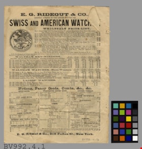
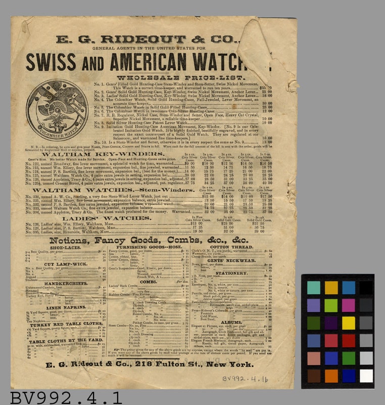
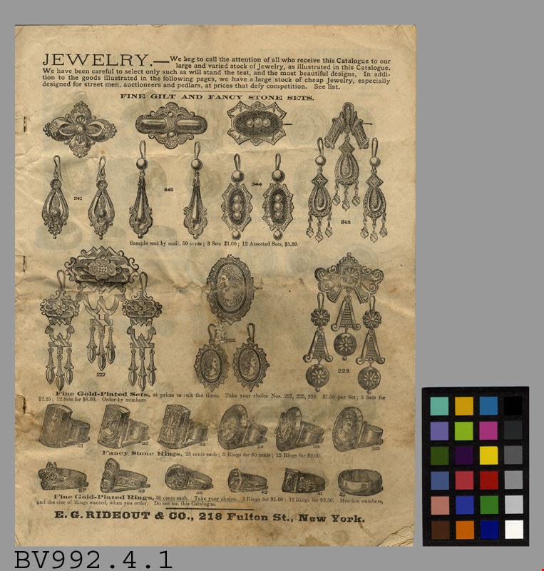
catalogue
https://search.heritageburnaby.ca/link/museumartifact18690
- Repository
- Burnaby Village Museum
- Accession Code
- BV992.4.1
- Description
- E.G. Rideout & Co. - Catalogue Booklet -- [1879?]. Catalogue produced by E.G. Rideout and Company in New York. The catalogue is staple bound although there are pages falling out of the booklet. The company advertises Swiss and American Watches for ladies and men, notions, combs, brooches, etc. Along with prices guides for the products. The booklet measures 21cm x 27cm.
- Maker
- E. G. Rideout & Co
- Country Made
- United States of America
- Province Made
- New York
- Site/City Made
- New York
Images
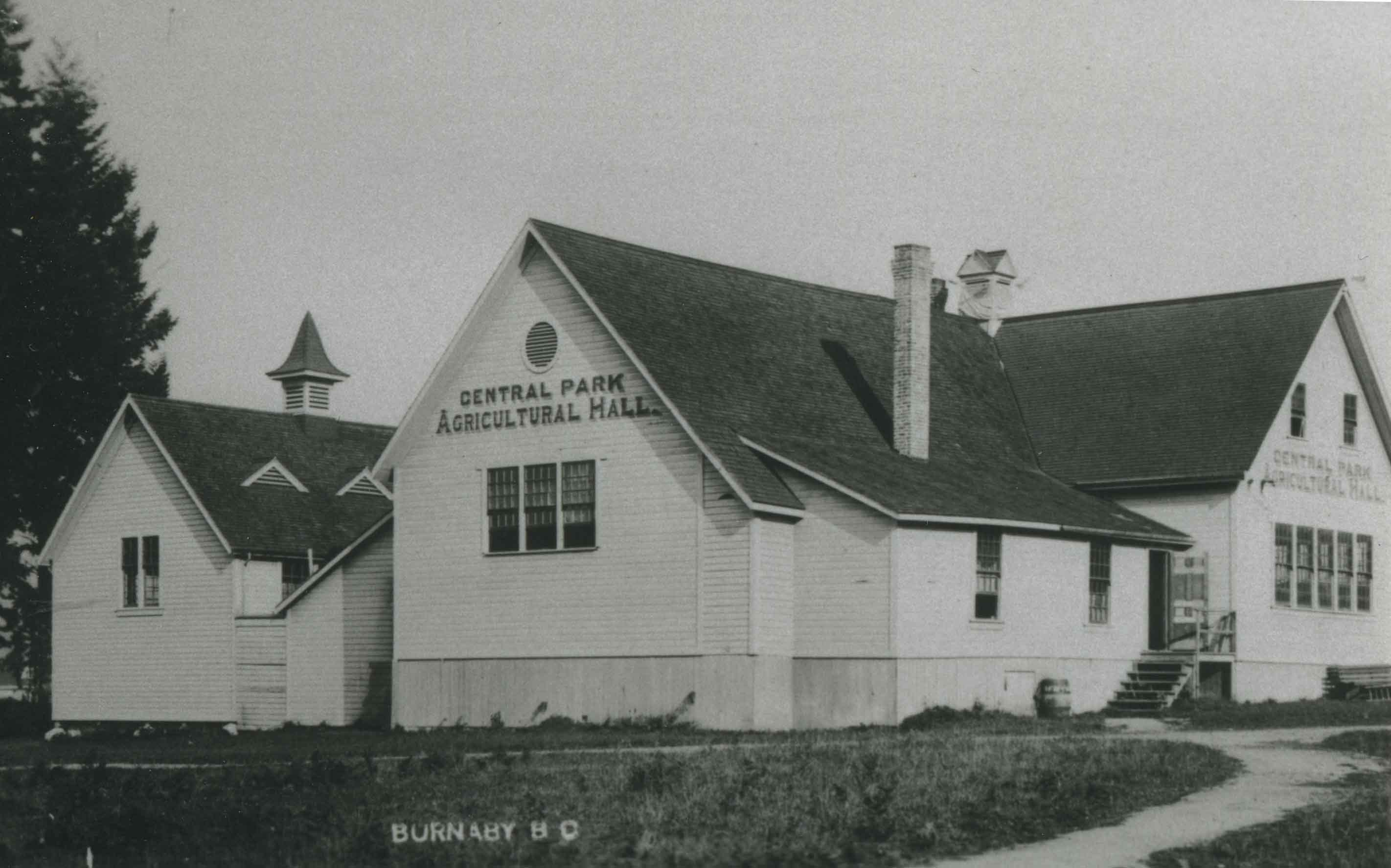
Central Park Agricultural Hall
https://search.heritageburnaby.ca/link/archivedescription36671
- Repository
- City of Burnaby Archives
- Date
- 1920 (date of original), copied 1992
- Collection/Fonds
- Burnaby Historical Society fonds
- Description Level
- Item
- Physical Description
- 1 photograph : b&w ; 10.1 x 14.9 cm print
- Scope and Content
- Photograph of the Central Park Agricultural Hall which was built on the triangular part of the park at Kingsway near Patterson.
- Repository
- City of Burnaby Archives
- Date
- 1920 (date of original), copied 1992
- Collection/Fonds
- Burnaby Historical Society fonds
- Subseries
- Burnaby Centennial Anthology subseries
- Physical Description
- 1 photograph : b&w ; 10.1 x 14.9 cm print
- Description Level
- Item
- Record No.
- 315-026
- Access Restriction
- No restrictions
- Reproduction Restriction
- No known restrictions
- Accession Number
- BHS1994-04
- Scope and Content
- Photograph of the Central Park Agricultural Hall which was built on the triangular part of the park at Kingsway near Patterson.
- Subjects
- Buildings - Agricultural
- Media Type
- Photograph
- Notes
- Title based on contents of photograph
- Copy taken from original b&w photographic postcard
- Geographic Access
- Central Park
- Imperial Street
- Street Address
- 3883 Imperial Street
- Historic Neighbourhood
- Central Park (Historic Neighbourhood)
- Planning Study Area
- Maywood Area
Images
![Chamberlain Chicken Coop, [ca. 1920] (date of original), copied 1986 thumbnail](/media/hpo/_Data/_Archives_Images/_Unrestricted/126/179-006.jpg?width=280)
Chamberlain Chicken Coop
https://search.heritageburnaby.ca/link/archivedescription35035
- Repository
- City of Burnaby Archives
- Date
- [ca. 1920] (date of original), copied 1986
- Collection/Fonds
- Burnaby Historical Society fonds
- Description Level
- Item
- Physical Description
- 1 photograph : b&w ; 8.8 x 12.6 cm print
- Scope and Content
- Photograph of the exterior of the Chamberlain family chicken coop. The coop was originally a house. A man and three cows are seen outside it. This may be 6389 Elgin Avenue.
- Repository
- City of Burnaby Archives
- Date
- [ca. 1920] (date of original), copied 1986
- Collection/Fonds
- Burnaby Historical Society fonds
- Subseries
- Chamberlain family subseries
- Physical Description
- 1 photograph : b&w ; 8.8 x 12.6 cm print
- Description Level
- Item
- Record No.
- 179-006
- Access Restriction
- No restrictions
- Reproduction Restriction
- No known restrictions
- Accession Number
- BHS1986-27
- Scope and Content
- Photograph of the exterior of the Chamberlain family chicken coop. The coop was originally a house. A man and three cows are seen outside it. This may be 6389 Elgin Avenue.
- Subjects
- Animals - Cows
- Buildings - Agricultural
- Media Type
- Photograph
- Notes
- Title based on contents of photograph
- Street Address
- 6389 Elgin Avenue
- Historic Neighbourhood
- Central Park (Historic Neighbourhood)
- Planning Study Area
- Windsor Area
Images
![Chamberlain Chicken Coop, [ca. 1920] (date of original), copied 1986 thumbnail](/media/hpo/_Data/_Archives_Images/_Unrestricted/126/179-006.jpg)
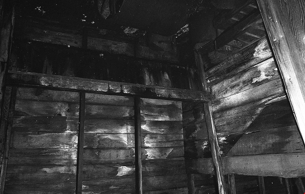
Chicken Hatchery at Royal Oak and Kingsway
https://search.heritageburnaby.ca/link/archivedescription37335
- Repository
- City of Burnaby Archives
- Date
- 1935
- Collection/Fonds
- Burnaby Historical Society fonds
- Description Level
- Item
- Physical Description
- 1 photograph : b&w negative ; 6 x 8.5 cm
- Scope and Content
- Photograph of the remnants of a burned building that was a chicken hatchery at Royal Oak and Kingsway.
- Repository
- City of Burnaby Archives
- Date
- 1935
- Collection/Fonds
- Burnaby Historical Society fonds
- Subseries
- Bernard Bellinger subseries
- Physical Description
- 1 photograph : b&w negative ; 6 x 8.5 cm
- Description Level
- Item
- Record No.
- 354-001
- Access Restriction
- No restrictions
- Reproduction Restriction
- No known restrictions
- Accession Number
- BHS1997-13
- Scope and Content
- Photograph of the remnants of a burned building that was a chicken hatchery at Royal Oak and Kingsway.
- Subjects
- Buildings - Agricultural
- Media Type
- Photograph
- Notes
- Title based on contents of photograph.
- Geographic Access
- Royal Oak Avenue
- Kingsway
- Historic Neighbourhood
- Central Park (Historic Neighbourhood)
Images

Chicken hatchery at Royal Oak and Kingsway
https://search.heritageburnaby.ca/link/archivedescription37336
- Repository
- City of Burnaby Archives
- Date
- 1935
- Collection/Fonds
- Burnaby Historical Society fonds
- Description Level
- Item
- Physical Description
- 1 photograph : b&w negative ; 6 x 8.5 cm
- Scope and Content
- Photograph of the remnants of a burned building that was a chicken hatchery at Royal Oak and Kingsway.
- Repository
- City of Burnaby Archives
- Date
- 1935
- Collection/Fonds
- Burnaby Historical Society fonds
- Subseries
- Bernard Bellinger subseries
- Physical Description
- 1 photograph : b&w negative ; 6 x 8.5 cm
- Description Level
- Item
- Record No.
- 354-002
- Access Restriction
- No restrictions
- Reproduction Restriction
- No known restrictions
- Accession Number
- BHS1997-13
- Scope and Content
- Photograph of the remnants of a burned building that was a chicken hatchery at Royal Oak and Kingsway.
- Subjects
- Buildings - Agricultural
- Media Type
- Photograph
- Notes
- Title based on contents of photograph.
- Geographic Access
- Royal Oak Avenue
- Kingsway
- Historic Neighbourhood
- Central Park (Historic Neighbourhood)
Images

Cunningham barn
https://search.heritageburnaby.ca/link/museumdescription17937
- Repository
- Burnaby Village Museum
- Date
- Jan. 1991
- Collection/Fonds
- Burnaby Village Museum Photograph collection
- Description Level
- Item
- Physical Description
- 1 photograph : col. negative ; 35 mm
- Scope and Content
- Photograph of the exterior of the Cunningham barn located at 3555 Douglas Road, Burnaby. The house and barn were built circa. 1923 on the property owned by Fred and Edna Cunningham. The Cunningham house was designated as a heritage building in 1996.
- Repository
- Burnaby Village Museum
- Collection/Fonds
- Burnaby Village Museum Photograph collection
- Description Level
- Item
- Physical Description
- 1 photograph : col. negative ; 35 mm
- Scope and Content
- Photograph of the exterior of the Cunningham barn located at 3555 Douglas Road, Burnaby. The house and barn were built circa. 1923 on the property owned by Fred and Edna Cunningham. The Cunningham house was designated as a heritage building in 1996.
- Subjects
- Buildings - Agricultural
- Geographic Access
- Douglas Road
- Street Address
- 3555 Douglas Road
- Accession Code
- BV022.3.1
- Access Restriction
- No restrictions
- Reproduction Restriction
- No known restrictions
- Date
- Jan. 1991
- Media Type
- Photograph
- Historic Neighbourhood
- Burnaby Lake (Historic Neighbourhood)
- Planning Study Area
- Douglas-Gilpin Area
- Scan Resolution
- 2400
- Scan Date
- 2021-08-24
- Photographer
- Stevens, Colin
- Notes
- Title based on contents of photograph
- Photograph from Roll P92-4, negative #1
- 1 b&w. print accompanying
- Note in black ink on verso of accompanying photograph print reads: "P92-4-1"
Images
Cunningham barn
https://search.heritageburnaby.ca/link/museumdescription17938
- Repository
- Burnaby Village Museum
- Date
- Jan. 1991
- Collection/Fonds
- Burnaby Village Museum Photograph collection
- Description Level
- Item
- Physical Description
- 1 photograph : col. negative ; 35 mm
- Scope and Content
- Photograph of the exterior of the Cunningham barn located at 3555 Douglas Road, Burnaby. The house and barn were built circa. 1923 on the property owned by Fred and Edna Cunningham. The Cunningham house was designated as a heritage building in 1996.
- Repository
- Burnaby Village Museum
- Collection/Fonds
- Burnaby Village Museum Photograph collection
- Description Level
- Item
- Physical Description
- 1 photograph : col. negative ; 35 mm
- Scope and Content
- Photograph of the exterior of the Cunningham barn located at 3555 Douglas Road, Burnaby. The house and barn were built circa. 1923 on the property owned by Fred and Edna Cunningham. The Cunningham house was designated as a heritage building in 1996.
- Subjects
- Buildings - Agricultural
- Geographic Access
- Douglas Road
- Street Address
- 3555 Douglas Road
- Accession Code
- BV022.3.2
- Access Restriction
- No restrictions
- Reproduction Restriction
- No known restrictions
- Date
- Jan. 1991
- Media Type
- Photograph
- Historic Neighbourhood
- Burnaby Lake (Historic Neighbourhood)
- Planning Study Area
- Douglas-Gilpin Area
- Scan Resolution
- 2400
- Scan Date
- 2021-08-24
- Photographer
- Stevens, Colin
- Notes
- Title based on contents of photograph
- Photograph from Roll P92-4, negative #2
- 1 b&w. print accompanying
- Note in black ink on verso of accompanying photograph print reads: "P92-4-2"
Images
Cunningham barn
https://search.heritageburnaby.ca/link/museumdescription17939
- Repository
- Burnaby Village Museum
- Date
- Jan. 1991
- Collection/Fonds
- Burnaby Village Museum Photograph collection
- Description Level
- Item
- Physical Description
- 1 photograph : col. negative ; 35 mm
- Scope and Content
- Photograph of the exterior of the Cunningham barn located at 3555 Douglas Road, Burnaby. The house and barn were built circa. 1923 on the property owned by Fred and Edna Cunningham. The Cunningham house was designated as a heritage building in 1996.
- Repository
- Burnaby Village Museum
- Collection/Fonds
- Burnaby Village Museum Photograph collection
- Description Level
- Item
- Physical Description
- 1 photograph : col. negative ; 35 mm
- Scope and Content
- Photograph of the exterior of the Cunningham barn located at 3555 Douglas Road, Burnaby. The house and barn were built circa. 1923 on the property owned by Fred and Edna Cunningham. The Cunningham house was designated as a heritage building in 1996.
- Subjects
- Buildings - Agricultural
- Geographic Access
- Douglas Road
- Street Address
- 3555 Douglas Road
- Accession Code
- BV022.3.3
- Access Restriction
- No restrictions
- Reproduction Restriction
- No known restrictions
- Date
- Jan. 1991
- Media Type
- Photograph
- Historic Neighbourhood
- Burnaby Lake (Historic Neighbourhood)
- Planning Study Area
- Douglas-Gilpin Area
- Scan Resolution
- 2400
- Scan Date
- 2021-08-24
- Photographer
- Stevens, Colin
- Notes
- Title based on contents of photograph
- Photograph from Roll P92-4, negative #3
- 1 b&w. print accompanying
- Note in black ink on verso of accompanying photograph print reads: "P92-4-3"
Images

Cunningham barn
https://search.heritageburnaby.ca/link/museumdescription17940
- Repository
- Burnaby Village Museum
- Date
- Jan. 1991
- Collection/Fonds
- Burnaby Village Museum Photograph collection
- Description Level
- Item
- Physical Description
- 1 photograph : col. negative ; 35 mm
- Scope and Content
- Photograph of the exterior of the Cunningham barn located at 3555 Douglas Road, Burnaby. The house and barn were built circa. 1923 on the property owned by Fred and Edna Cunningham. The Cunningham house was designated as a heritage building in 1996.
- Repository
- Burnaby Village Museum
- Collection/Fonds
- Burnaby Village Museum Photograph collection
- Description Level
- Item
- Physical Description
- 1 photograph : col. negative ; 35 mm
- Scope and Content
- Photograph of the exterior of the Cunningham barn located at 3555 Douglas Road, Burnaby. The house and barn were built circa. 1923 on the property owned by Fred and Edna Cunningham. The Cunningham house was designated as a heritage building in 1996.
- Subjects
- Buildings - Agricultural
- Geographic Access
- Douglas Road
- Street Address
- 3555 Douglas Road
- Accession Code
- BV022.3.4
- Access Restriction
- No restrictions
- Reproduction Restriction
- No known restrictions
- Date
- Jan. 1991
- Media Type
- Photograph
- Historic Neighbourhood
- Burnaby Lake (Historic Neighbourhood)
- Planning Study Area
- Douglas-Gilpin Area
- Scan Resolution
- 2400
- Scan Date
- 2021-08-24
- Photographer
- Stevens, Colin
- Notes
- Title based on contents of photograph
- Photograph from Roll P92-4, negative #4
- 1 b&w. print accompanying
- Note in black ink on verso of accompanying photograph print reads: "P92-4-4"
Images
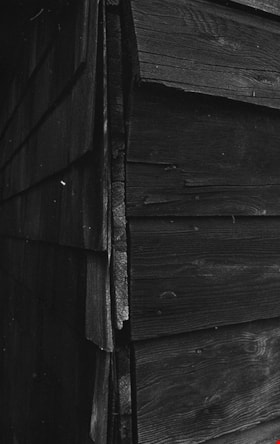
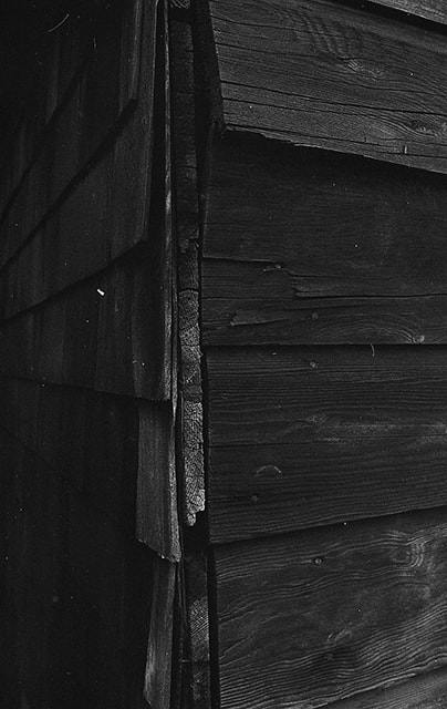
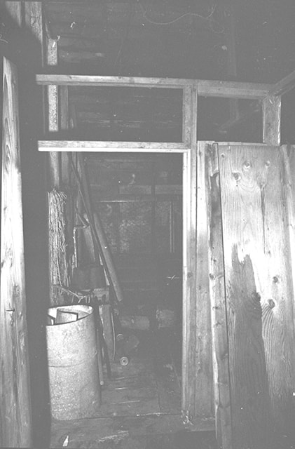
Exterior siding on Cunningham barn
https://search.heritageburnaby.ca/link/museumdescription17952
- Repository
- Burnaby Village Museum
- Date
- Jan. 1991
- Collection/Fonds
- Burnaby Village Museum Photograph collection
- Description Level
- Item
- Physical Description
- 1 photograph : col. negative ; 35 mm
- Scope and Content
- Photograph of the exterior wooden siding of the Cunningham barn located at 3555 Douglas Road, Burnaby. View includes exterior corner of barn. The house and barn were built circa. 1923 on the property owned by Fred and Edna Cunningham. The Cunningham house was designated as a heritage building in 19…
- Repository
- Burnaby Village Museum
- Collection/Fonds
- Burnaby Village Museum Photograph collection
- Description Level
- Item
- Physical Description
- 1 photograph : col. negative ; 35 mm
- Scope and Content
- Photograph of the exterior wooden siding of the Cunningham barn located at 3555 Douglas Road, Burnaby. View includes exterior corner of barn. The house and barn were built circa. 1923 on the property owned by Fred and Edna Cunningham. The Cunningham house was designated as a heritage building in 1996.
- Subjects
- Buildings - Agricultural
- Geographic Access
- Douglas Road
- Street Address
- 3555 Douglas Road
- Accession Code
- BV022.3.16
- Access Restriction
- No restrictions
- Reproduction Restriction
- No known restrictions
- Date
- Jan. 1991
- Media Type
- Photograph
- Historic Neighbourhood
- Burnaby Lake (Historic Neighbourhood)
- Planning Study Area
- Douglas-Gilpin Area
- Scan Resolution
- 2400
- Scan Date
- 2021-08-24
- Photographer
- Stevens, Colin
- Notes
- Title based on contents of photograph
- Photograph from Roll P92-4, negative #16
- 1 b&w. print accompanying
- Note in black ink on verso of accompanying photograph print reads: "P92-4-16"
Images

Farrington Chicken Ranch
https://search.heritageburnaby.ca/link/archivedescription35226
- Repository
- City of Burnaby Archives
- Date
- 1920 (date of original), copied 1986
- Collection/Fonds
- Burnaby Historical Society fonds
- Description Level
- Item
- Physical Description
- 1 photograph : b&w ; 12.7 x 17.8 cm print
- Scope and Content
- Photograph of the Farrington brothers' chicken ranch near Central Park at 3907 Chesham Avenue (later renumbered 5384 Chesham Avenue). Brothers Thomas Farrington and Richard Farrington founded Wheat Sheaf Poultry Ranch in 1919. The laying house is at the left, and the family home is at the right.
- Repository
- City of Burnaby Archives
- Date
- 1920 (date of original), copied 1986
- Collection/Fonds
- Burnaby Historical Society fonds
- Subseries
- Pioneer Tales subseries
- Physical Description
- 1 photograph : b&w ; 12.7 x 17.8 cm print
- Description Level
- Item
- Record No.
- 204-083
- Access Restriction
- No restrictions
- Reproduction Restriction
- No known restrictions
- Accession Number
- BHS1988-03
- Scope and Content
- Photograph of the Farrington brothers' chicken ranch near Central Park at 3907 Chesham Avenue (later renumbered 5384 Chesham Avenue). Brothers Thomas Farrington and Richard Farrington founded Wheat Sheaf Poultry Ranch in 1919. The laying house is at the left, and the family home is at the right.
- Subjects
- Buildings - Agricultural
- Animals - Poultry
- Agriculture - Poultry
- Buildings - Residential - Houses
- Media Type
- Photograph
- Notes
- Title based on contents of photograph
- Geographic Access
- Chesham Avenue
- Street Address
- 5384 Chesham Avenue
- Historic Neighbourhood
- Central Park (Historic Neighbourhood)
- Planning Study Area
- Garden Village Area
Images


Farrington Laying House
https://search.heritageburnaby.ca/link/archivedescription35227
- Repository
- City of Burnaby Archives
- Date
- 1920 (date of original), copied 1986
- Collection/Fonds
- Burnaby Historical Society fonds
- Description Level
- Item
- Physical Description
- 1 photograph : b&w ; 12.7 x 17.8 cm print
- Scope and Content
- Photograph of Farrington brothers' chicken laying house. Brothers Thomas Farrington and Richard Farrington founded Wheat Sheaf Poultry Ranch in 1919. It was located at 3907 Chesham Avenue (later renumbered 5384 Chesham Avenue).
- Repository
- City of Burnaby Archives
- Date
- 1920 (date of original), copied 1986
- Collection/Fonds
- Burnaby Historical Society fonds
- Subseries
- Pioneer Tales subseries
- Physical Description
- 1 photograph : b&w ; 12.7 x 17.8 cm print
- Description Level
- Item
- Record No.
- 204-084
- Access Restriction
- No restrictions
- Reproduction Restriction
- No known restrictions
- Accession Number
- BHS1988-03
- Scope and Content
- Photograph of Farrington brothers' chicken laying house. Brothers Thomas Farrington and Richard Farrington founded Wheat Sheaf Poultry Ranch in 1919. It was located at 3907 Chesham Avenue (later renumbered 5384 Chesham Avenue).
- Media Type
- Photograph
- Notes
- Title based on contents of photograph
- Geographic Access
- Chesham Avenue
- Street Address
- 5384 Chesham Avenue
- Historic Neighbourhood
- Central Park (Historic Neighbourhood)
- Planning Study Area
- Garden Village Area
Images

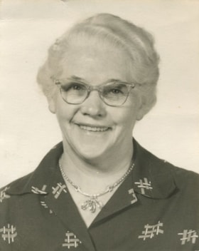
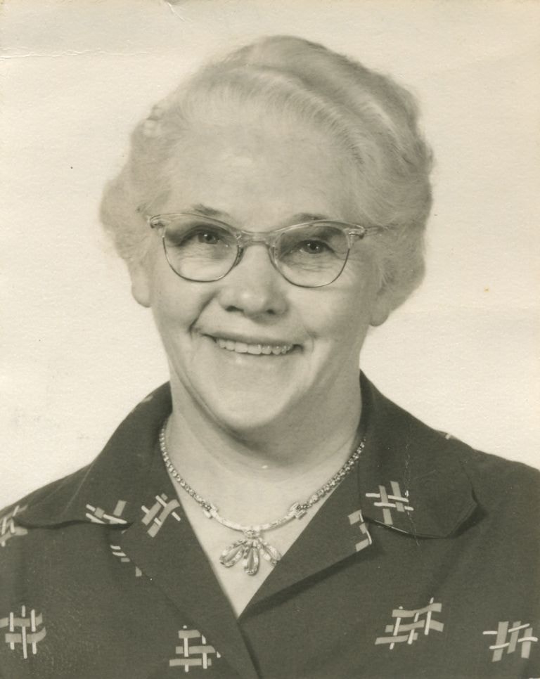
Flora Bell
https://search.heritageburnaby.ca/link/museumdescription1952
- Repository
- Burnaby Village Museum
- Date
- 1960
- Collection/Fonds
- Burnaby Village Museum Photograph collection
- Description Level
- Item
- Physical Description
- 1 photograph : b&w ; 6.5 x 5 cm
- Scope and Content
- Photograph of Flora Bell.
- Repository
- Burnaby Village Museum
- Collection/Fonds
- Burnaby Village Museum Photograph collection
- Description Level
- Item
- Physical Description
- 1 photograph : b&w ; 6.5 x 5 cm
- Scope and Content
- Photograph of Flora Bell.
- Subjects
- Adornment - Jewelry
- Names
- Bell, Flora
- Accession Code
- BV005.69.2
- Access Restriction
- Restricted access
- Reproduction Restriction
- May be restricted by third party rights
- Date
- 1960
- Media Type
- Photograph
- Scan Resolution
- 600
- Scan Date
- 11-Jun-09
- Scale
- 100
- Notes
- Title based on contents of photograph
- Note in black ink on verso of photograph reads: "PLEASE RETURN TO:/ May Long/ 14428 - 18A Ave/ White Rock BC/ V4A 8S6", b. "~1960/ MRS. FLORA BELL"
Images
![Fruit Processing Plant, [195-] thumbnail](/media/hpo/_Data/_Archives_Images/_Unrestricted/001/085-001.jpg?width=280)
Fruit Processing Plant
https://search.heritageburnaby.ca/link/archivedescription34664
- Repository
- City of Burnaby Archives
- Date
- [195-]
- Collection/Fonds
- Burnaby Historical Society fonds
- Description Level
- Item
- Physical Description
- 1 photograph : b&w ; 18.1 x 23.2 cm
- Scope and Content
- Photograph of the exterior of a fruit processing plant in the Kingsway Area.
- Repository
- City of Burnaby Archives
- Date
- [195-]
- Collection/Fonds
- Burnaby Historical Society fonds
- Subseries
- Photographs subseries
- Physical Description
- 1 photograph : b&w ; 18.1 x 23.2 cm
- Description Level
- Item
- Record No.
- 085-001
- Access Restriction
- No restrictions
- Reproduction Restriction
- Reproduce for fair dealing purposes only
- Accession Number
- BHS2007-04
- Scope and Content
- Photograph of the exterior of a fruit processing plant in the Kingsway Area.
- Media Type
- Photograph
- Notes
- Title based on contents of photograph
- Geographic Access
- Kingsway
Images
![Fruit Processing Plant, [195-] thumbnail](/media/hpo/_Data/_Archives_Images/_Unrestricted/001/085-001.jpg)

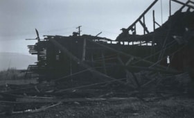
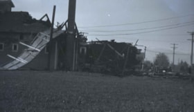
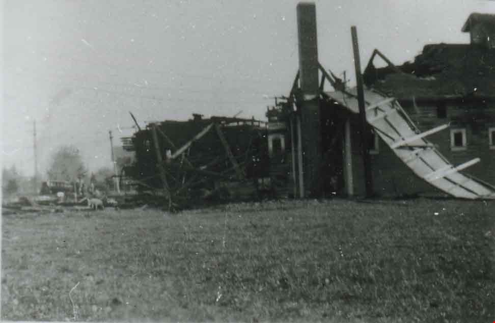
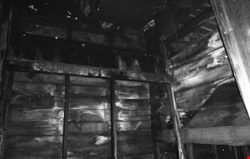
Hatchery
https://search.heritageburnaby.ca/link/archivedescription37458
- Repository
- City of Burnaby Archives
- Date
- 1931 (date of original), copied 1991
- Collection/Fonds
- Burnaby Historical Society fonds
- Description Level
- Item
- Physical Description
- 1 photograph : b&w ; 2.2 x 4.1 cm print on contact sheet 20.2 x 25.3 cm
- Scope and Content
- Photograph of the aftermath of a hatchery fire at Royal Oak, west of Kingsway.
- Repository
- City of Burnaby Archives
- Date
- 1931 (date of original), copied 1991
- Collection/Fonds
- Burnaby Historical Society fonds
- Subseries
- Burnaby Image Bank subseries
- Physical Description
- 1 photograph : b&w ; 2.2 x 4.1 cm print on contact sheet 20.2 x 25.3 cm
- Description Level
- Item
- Record No.
- 370-046
- Access Restriction
- No restrictions
- Reproduction Restriction
- No known restrictions
- Accession Number
- BHS1999-03
- Scope and Content
- Photograph of the aftermath of a hatchery fire at Royal Oak, west of Kingsway.
- Subjects
- Buildings - Agricultural
- Media Type
- Photograph
- Photographer
- Bellinger, Bernard
- Notes
- Title based on contents of photograph
- 1 b&w copy negative accompanying
- Geographic Access
- Royal Oak Avenue
- Kingsway
- Historic Neighbourhood
- Central Park (Historic Neighbourhood)
- Planning Study Area
- Marlborough Area
Images
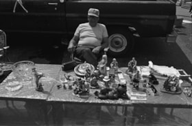
Household trinkets and jewelry
https://search.heritageburnaby.ca/link/archivedescription70269
- Repository
- City of Burnaby Archives
- Date
- 1978
- Collection/Fonds
- Bill Jeffries fonds
- Description Level
- Item
- Physical Description
- 1 photograph : b&w negative ; 35 mm
- Scope and Content
- Photograph of a table filled with household trinkets and jewelry at the Lougheed Drive-in swap meet in the summer of 1978. An unidentified vendor in a BC Lions baseball cap is sitting behind the table.
- Repository
- City of Burnaby Archives
- Date
- 1978
- Collection/Fonds
- Bill Jeffries fonds
- Physical Description
- 1 photograph : b&w negative ; 35 mm
- Description Level
- Item
- Record No.
- 528-003
- Access Restriction
- No restrictions
- Reproduction Restriction
- No restrictions
- Accession Number
- 2011-01
- Scope and Content
- Photograph of a table filled with household trinkets and jewelry at the Lougheed Drive-in swap meet in the summer of 1978. An unidentified vendor in a BC Lions baseball cap is sitting behind the table.
- Subjects
- Adornment - Jewelry
- Media Type
- Photograph
- Photographer
- Jeffries, Bill
- Notes
- Title based on contents of item
- Geographic Access
- Lougheed Highway
- Historic Neighbourhood
- Broadview (Historic Neighbourhood)
- Planning Study Area
- West Central Valley Area
Images
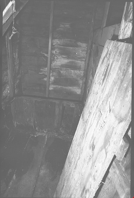
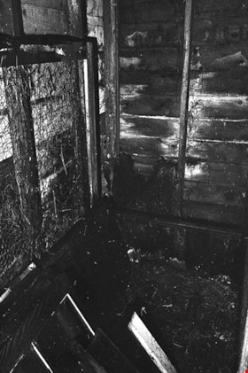
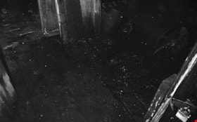
Interior of Cunningham barn
https://search.heritageburnaby.ca/link/museumdescription17942
- Repository
- Burnaby Village Museum
- Date
- Jan. 1991
- Collection/Fonds
- Burnaby Village Museum Photograph collection
- Description Level
- Item
- Physical Description
- 1 photograph : col. negative ; 35 mm
- Scope and Content
- Photograph of the interior of the Cunningham barn located at 3555 Douglas Road, Burnaby. Interior view includes wood walls and what appears to be a feeding trough for farm animals. The house and barn were built circa. 1923 on the property owned by Fred and Edna Cunningham. The Cunningham house was …
- Repository
- Burnaby Village Museum
- Collection/Fonds
- Burnaby Village Museum Photograph collection
- Description Level
- Item
- Physical Description
- 1 photograph : col. negative ; 35 mm
- Scope and Content
- Photograph of the interior of the Cunningham barn located at 3555 Douglas Road, Burnaby. Interior view includes wood walls and what appears to be a feeding trough for farm animals. The house and barn were built circa. 1923 on the property owned by Fred and Edna Cunningham. The Cunningham house was designated as a heritage building in 1996.
- Subjects
- Buildings - Agricultural
- Geographic Access
- Douglas Road
- Street Address
- 3555 Douglas Road
- Accession Code
- BV022.3.6
- Access Restriction
- No restrictions
- Reproduction Restriction
- No known restrictions
- Date
- Jan. 1991
- Media Type
- Photograph
- Historic Neighbourhood
- Burnaby Lake (Historic Neighbourhood)
- Planning Study Area
- Douglas-Gilpin Area
- Scan Resolution
- 2400
- Scan Date
- 2021-08-24
- Photographer
- Stevens, Colin
- Notes
- Title based on contents of photograph
- Photograph from Roll P92-4, negative #6
- 1 b&w. print accompanying
- Note in black ink on verso of accompanying photograph print reads: "P92-4-6"
Images


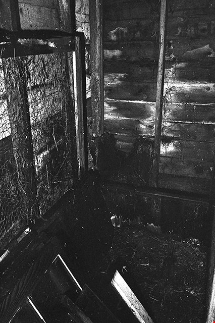
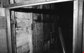
Interior of Cunningham barn
https://search.heritageburnaby.ca/link/museumdescription17943
- Repository
- Burnaby Village Museum
- Date
- Jan. 1991
- Collection/Fonds
- Burnaby Village Museum Photograph collection
- Description Level
- Item
- Physical Description
- 1 photograph : col. negative ; 35 mm
- Scope and Content
- Photograph of the interior of the Cunningham barn located at 3555 Douglas Road, Burnaby. Interior view of doorway with door frame, various tools and materials. The house and barn were built circa. 1923 on the property owned by Fred and Edna Cunningham. The Cunningham house was designated as a herit…
- Repository
- Burnaby Village Museum
- Collection/Fonds
- Burnaby Village Museum Photograph collection
- Description Level
- Item
- Physical Description
- 1 photograph : col. negative ; 35 mm
- Scope and Content
- Photograph of the interior of the Cunningham barn located at 3555 Douglas Road, Burnaby. Interior view of doorway with door frame, various tools and materials. The house and barn were built circa. 1923 on the property owned by Fred and Edna Cunningham. The Cunningham house was designated as a heritage building in 1996.
- Subjects
- Buildings - Agricultural
- Geographic Access
- Douglas Road
- Street Address
- 3555 Douglas Road
- Accession Code
- BV022.3.7
- Access Restriction
- No restrictions
- Reproduction Restriction
- No known restrictions
- Date
- Jan. 1991
- Media Type
- Photograph
- Historic Neighbourhood
- Burnaby Lake (Historic Neighbourhood)
- Planning Study Area
- Douglas-Gilpin Area
- Scan Resolution
- 2400
- Scan Date
- 2021-08-24
- Photographer
- Stevens, Colin
- Notes
- Title based on contents of photograph
- Photograph from Roll P92-4, negative #7
- 1 b&w. print accompanying
- Note in black ink on verso of accompanying photograph print reads: "P92-4-7"
Images

Interior of Cunningham barn
https://search.heritageburnaby.ca/link/museumdescription17944
- Repository
- Burnaby Village Museum
- Date
- Jan. 1991
- Collection/Fonds
- Burnaby Village Museum Photograph collection
- Description Level
- Item
- Physical Description
- 1 photograph : col. negative ; 35 mm
- Scope and Content
- Photograph of the interior walls of the Cunningham barn located at 3555 Douglas Road, Burnaby. The house and barn were built circa. 1923 on the property owned by Fred and Edna Cunningham. The Cunningham house was designated as a heritage building in 1996.
- Repository
- Burnaby Village Museum
- Collection/Fonds
- Burnaby Village Museum Photograph collection
- Description Level
- Item
- Physical Description
- 1 photograph : col. negative ; 35 mm
- Scope and Content
- Photograph of the interior walls of the Cunningham barn located at 3555 Douglas Road, Burnaby. The house and barn were built circa. 1923 on the property owned by Fred and Edna Cunningham. The Cunningham house was designated as a heritage building in 1996.
- Subjects
- Buildings - Agricultural
- Geographic Access
- Douglas Road
- Street Address
- 3555 Douglas Road
- Accession Code
- BV022.3.8
- Access Restriction
- No restrictions
- Reproduction Restriction
- No known restrictions
- Date
- Jan. 1991
- Media Type
- Photograph
- Historic Neighbourhood
- Burnaby Lake (Historic Neighbourhood)
- Planning Study Area
- Douglas-Gilpin Area
- Scan Resolution
- 2400
- Scan Date
- 2021-08-24
- Photographer
- Stevens, Colin
- Notes
- Title based on contents of photograph
- Photograph from Roll P92-4, negative #8
- 1 b&w. print accompanying
- Note in black ink on verso of accompanying photograph print reads: "P92-4-8"
Images
Interior of Cunningham barn
https://search.heritageburnaby.ca/link/museumdescription17945
- Repository
- Burnaby Village Museum
- Date
- Jan. 1991
- Collection/Fonds
- Burnaby Village Museum Photograph collection
- Description Level
- Item
- Physical Description
- 1 photograph : col. negative ; 35 mm
- Scope and Content
- Photograph of the interior of the Cunningham barn located at 3555 Douglas Road, Burnaby. Interior view includes parts of what might be farming machinery, pieces of wood and a water pipe with two shut off valves. The house and barn were built circa. 1923 on the property owned by Fred and Edna Cunnin…
- Repository
- Burnaby Village Museum
- Collection/Fonds
- Burnaby Village Museum Photograph collection
- Description Level
- Item
- Physical Description
- 1 photograph : col. negative ; 35 mm
- Scope and Content
- Photograph of the interior of the Cunningham barn located at 3555 Douglas Road, Burnaby. Interior view includes parts of what might be farming machinery, pieces of wood and a water pipe with two shut off valves. The house and barn were built circa. 1923 on the property owned by Fred and Edna Cunningham. The Cunningham house was designated as a heritage building in 1996.
- Subjects
- Buildings - Agricultural
- Geographic Access
- Douglas Road
- Street Address
- 3555 Douglas Road
- Accession Code
- BV022.3.9
- Access Restriction
- No restrictions
- Reproduction Restriction
- No known restrictions
- Date
- Jan. 1991
- Media Type
- Photograph
- Historic Neighbourhood
- Burnaby Lake (Historic Neighbourhood)
- Planning Study Area
- Douglas-Gilpin Area
- Scan Resolution
- 2400
- Scan Date
- 2021-08-24
- Photographer
- Stevens, Colin
- Notes
- Title based on contents of photograph
- Photograph from Roll P92-4, negative #9
- 1 b&w. print accompanying
- Note in black ink on verso of accompanying photograph print reads: "P92-4-9"
Images
Interior of Cunningham barn
https://search.heritageburnaby.ca/link/museumdescription17946
- Repository
- Burnaby Village Museum
- Date
- Jan. 1991
- Collection/Fonds
- Burnaby Village Museum Photograph collection
- Description Level
- Item
- Physical Description
- 1 photograph : col. negative ; 35 mm
- Scope and Content
- Photograph of the interior of the Cunningham barn located at 3555 Douglas Road, Burnaby. Interior view includes wooden walls and chicken wire fencing. The house and barn were built circa. 1923 on the property owned by Fred and Edna Cunningham. The Cunningham house was designated as a heritage build…
- Repository
- Burnaby Village Museum
- Collection/Fonds
- Burnaby Village Museum Photograph collection
- Description Level
- Item
- Physical Description
- 1 photograph : col. negative ; 35 mm
- Scope and Content
- Photograph of the interior of the Cunningham barn located at 3555 Douglas Road, Burnaby. Interior view includes wooden walls and chicken wire fencing. The house and barn were built circa. 1923 on the property owned by Fred and Edna Cunningham. The Cunningham house was designated as a heritage building in 1996.
- Subjects
- Buildings - Agricultural
- Geographic Access
- Douglas Road
- Street Address
- 3555 Douglas Road
- Accession Code
- BV022.3.10
- Access Restriction
- No restrictions
- Reproduction Restriction
- No known restrictions
- Date
- Jan. 1991
- Media Type
- Photograph
- Historic Neighbourhood
- Burnaby Lake (Historic Neighbourhood)
- Planning Study Area
- Douglas-Gilpin Area
- Scan Resolution
- 2400
- Scan Date
- 2021-08-24
- Photographer
- Stevens, Colin
- Notes
- Title based on contents of photograph
- Photograph from Roll P92-4, negative #10
- 1 b&w. print accompanying
- Note in black ink on verso of accompanying photograph print reads: "P92-4-10"
Images
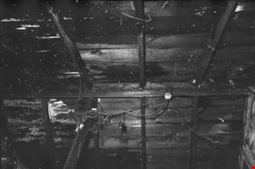
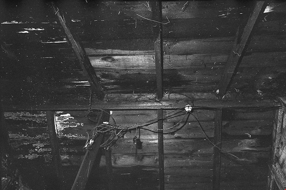
Interior of Cunningham barn
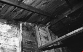
https://search.heritageburnaby.ca/link/museumdescription17947
- Repository
- Burnaby Village Museum
- Date
- Jan. 1991
- Collection/Fonds
- Burnaby Village Museum Photograph collection
- Description Level
- Item
- Physical Description
- 1 photograph : col. negative ; 35 mm
- Scope and Content
- Photograph of the interior of the Cunningham barn located at 3555 Douglas Road, Burnaby. Interior view of wood ceiling with electrical wiring. The house and barn were built circa. 1923 on the property owned by Fred and Edna Cunningham. The Cunningham house was designated as a heritage building in 1…
- Repository
- Burnaby Village Museum
- Collection/Fonds
- Burnaby Village Museum Photograph collection
- Description Level
- Item
- Physical Description
- 1 photograph : col. negative ; 35 mm
- Scope and Content
- Photograph of the interior of the Cunningham barn located at 3555 Douglas Road, Burnaby. Interior view of wood ceiling with electrical wiring. The house and barn were built circa. 1923 on the property owned by Fred and Edna Cunningham. The Cunningham house was designated as a heritage building in 1996.
- Subjects
- Buildings - Agricultural
- Geographic Access
- Douglas Road
- Street Address
- 3555 Douglas Road
- Accession Code
- BV022.3.11
- Access Restriction
- No restrictions
- Reproduction Restriction
- No known restrictions
- Date
- Jan. 1991
- Media Type
- Photograph
- Historic Neighbourhood
- Burnaby Lake (Historic Neighbourhood)
- Planning Study Area
- Douglas-Gilpin Area
- Scan Resolution
- 2400
- Scan Date
- 2021-08-24
- Photographer
- Stevens, Colin
- Notes
- Title based on contents of photograph
- Photograph from Roll P92-4, negative #11
- 1 b&w. print accompanying
- Note in black ink on verso of accompanying photograph print reads: "P92-4-11"
Images
Interior of Cunningham barn
https://search.heritageburnaby.ca/link/museumdescription17948
- Repository
- Burnaby Village Museum
- Date
- Jan. 1991
- Collection/Fonds
- Burnaby Village Museum Photograph collection
- Description Level
- Item
- Physical Description
- 1 photograph : col. negative ; 35 mm
- Scope and Content
- Photograph of the interior of the Cunningham barn located at 3555 Douglas Road, Burnaby. Interior view of wood door and wall. The house and barn were built circa. 1923 on the property owned by Fred and Edna Cunningham. The Cunningham house was designated as a heritage building in 1996.
- Repository
- Burnaby Village Museum
- Collection/Fonds
- Burnaby Village Museum Photograph collection
- Description Level
- Item
- Physical Description
- 1 photograph : col. negative ; 35 mm
- Scope and Content
- Photograph of the interior of the Cunningham barn located at 3555 Douglas Road, Burnaby. Interior view of wood door and wall. The house and barn were built circa. 1923 on the property owned by Fred and Edna Cunningham. The Cunningham house was designated as a heritage building in 1996.
- Subjects
- Buildings - Agricultural
- Geographic Access
- Douglas Road
- Street Address
- 3555 Douglas Road
- Accession Code
- BV022.3.12
- Access Restriction
- No restrictions
- Reproduction Restriction
- No known restrictions
- Date
- Jan. 1991
- Media Type
- Photograph
- Historic Neighbourhood
- Burnaby Lake (Historic Neighbourhood)
- Planning Study Area
- Douglas-Gilpin Area
- Scan Resolution
- 2400
- Scan Date
- 2021-08-24
- Photographer
- Stevens, Colin
- Notes
- Title based on contents of photograph
- Photograph from Roll P92-4, negative #12
- 1 b&w. print accompanying
- Note in black ink on verso of accompanying photograph print reads: "P92-4-12"
Images

Interior of Cunningham barn
https://search.heritageburnaby.ca/link/museumdescription17949
- Repository
- Burnaby Village Museum
- Date
- Jan. 1991
- Collection/Fonds
- Burnaby Village Museum Photograph collection
- Description Level
- Item
- Physical Description
- 1 photograph : col. negative ; 35 mm
- Scope and Content
- Photograph of the interior of the Cunningham barn located at 3555 Douglas Road, Burnaby. Interior view of wood floor and doorway with padlock. The house and barn were built circa. 1923 on the property owned by Fred and Edna Cunningham. The Cunningham house was designated as a heritage building in 1…
- Repository
- Burnaby Village Museum
- Collection/Fonds
- Burnaby Village Museum Photograph collection
- Description Level
- Item
- Physical Description
- 1 photograph : col. negative ; 35 mm
- Scope and Content
- Photograph of the interior of the Cunningham barn located at 3555 Douglas Road, Burnaby. Interior view of wood floor and doorway with padlock. The house and barn were built circa. 1923 on the property owned by Fred and Edna Cunningham. The Cunningham house was designated as a heritage building in 1996.
- Subjects
- Buildings - Agricultural
- Geographic Access
- Douglas Road
- Street Address
- 3555 Douglas Road
- Accession Code
- BV022.3.13
- Access Restriction
- No restrictions
- Reproduction Restriction
- No known restrictions
- Date
- Jan. 1991
- Media Type
- Photograph
- Historic Neighbourhood
- Burnaby Lake (Historic Neighbourhood)
- Planning Study Area
- Douglas-Gilpin Area
- Scan Resolution
- 2400
- Scan Date
- 2021-08-24
- Photographer
- Stevens, Colin
- Notes
- Title based on contents of photograph
- Photograph from Roll P92-4, negative #13
Images

Interior of Cunningham barn
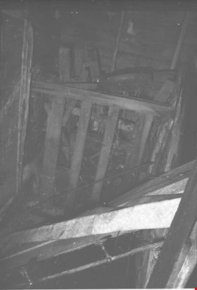
https://search.heritageburnaby.ca/link/museumdescription17950
- Repository
- Burnaby Village Museum
- Date
- Jan. 1991
- Collection/Fonds
- Burnaby Village Museum Photograph collection
- Description Level
- Item
- Physical Description
- 1 photograph : col. negative ; 35 mm
- Scope and Content
- Photograph of the interior of the Cunningham barn located at 3555 Douglas Road, Burnaby. Interior view of wood ceiling and rafters. The house and barn were built circa. 1923 on the property owned by Fred and Edna Cunningham. The Cunningham house was designated as a heritage building in 1996.
- Repository
- Burnaby Village Museum
- Collection/Fonds
- Burnaby Village Museum Photograph collection
- Description Level
- Item
- Physical Description
- 1 photograph : col. negative ; 35 mm
- Scope and Content
- Photograph of the interior of the Cunningham barn located at 3555 Douglas Road, Burnaby. Interior view of wood ceiling and rafters. The house and barn were built circa. 1923 on the property owned by Fred and Edna Cunningham. The Cunningham house was designated as a heritage building in 1996.
- Subjects
- Buildings - Agricultural
- Geographic Access
- Douglas Road
- Street Address
- 3555 Douglas Road
- Accession Code
- BV022.3.14
- Access Restriction
- No restrictions
- Reproduction Restriction
- No known restrictions
- Date
- Jan. 1991
- Media Type
- Photograph
- Historic Neighbourhood
- Burnaby Lake (Historic Neighbourhood)
- Planning Study Area
- Douglas-Gilpin Area
- Scan Resolution
- 2400
- Scan Date
- 2021-08-24
- Photographer
- Stevens, Colin
- Notes
- Title based on contents of photograph
- Photograph from Roll P92-4, negative #14
- 1 b&w. print accompanying
- Note in black ink on verso of accompanying photograph print reads: "P92-4-14"
Images

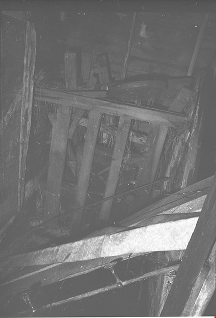
Interior of Cunningham barn
https://search.heritageburnaby.ca/link/museumdescription17951
- Repository
- Burnaby Village Museum
- Date
- Jan. 1991
- Collection/Fonds
- Burnaby Village Museum Photograph collection
- Description Level
- Item
- Physical Description
- 1 photograph : col. negative ; 35 mm
- Scope and Content
- Photograph of the interior of the Cunningham barn located at 3555 Douglas Road, Burnaby. Interior view of wood walls and a supply of rope hanging from a wooden rafter. The house and barn were built circa. 1923 on the property owned by Fred and Edna Cunningham. The Cunningham house was designated as…
- Repository
- Burnaby Village Museum
- Collection/Fonds
- Burnaby Village Museum Photograph collection
- Description Level
- Item
- Physical Description
- 1 photograph : col. negative ; 35 mm
- Scope and Content
- Photograph of the interior of the Cunningham barn located at 3555 Douglas Road, Burnaby. Interior view of wood walls and a supply of rope hanging from a wooden rafter. The house and barn were built circa. 1923 on the property owned by Fred and Edna Cunningham. The Cunningham house was designated as a heritage building in 1996.
- Subjects
- Buildings - Agricultural
- Geographic Access
- Douglas Road
- Street Address
- 3555 Douglas Road
- Accession Code
- BV022.3.15
- Access Restriction
- No restrictions
- Reproduction Restriction
- No known restrictions
- Date
- Jan. 1991
- Media Type
- Photograph
- Historic Neighbourhood
- Burnaby Lake (Historic Neighbourhood)
- Planning Study Area
- Douglas-Gilpin Area
- Scan Resolution
- 2400
- Scan Date
- 2021-08-24
- Photographer
- Stevens, Colin
- Notes
- Title based on contents of photograph
- Photograph from Roll P92-4, negative #15
- 1 b&w. print accompanying
- Note in black ink on verso of accompanying photograph print reads: "P92-4-15"
Images

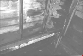
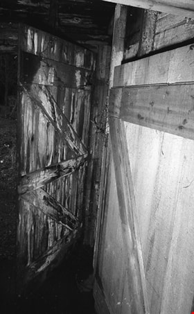
Interior walls of Cunningham barn
https://search.heritageburnaby.ca/link/museumdescription17941
- Repository
- Burnaby Village Museum
- Date
- Jan. 1991
- Collection/Fonds
- Burnaby Village Museum Photograph collection
- Description Level
- Item
- Physical Description
- 1 photograph : col. negative ; 35 mm
- Scope and Content
- Photograph of the interior walls of the Cunningham barn located at 3555 Douglas Road, Burnaby. The house and barn were built circa. 1923 on the property owned by Fred and Edna Cunningham. The Cunningham house was designated as a heritage building in 1996.
- Repository
- Burnaby Village Museum
- Collection/Fonds
- Burnaby Village Museum Photograph collection
- Description Level
- Item
- Physical Description
- 1 photograph : col. negative ; 35 mm
- Scope and Content
- Photograph of the interior walls of the Cunningham barn located at 3555 Douglas Road, Burnaby. The house and barn were built circa. 1923 on the property owned by Fred and Edna Cunningham. The Cunningham house was designated as a heritage building in 1996.
- Subjects
- Buildings - Agricultural
- Geographic Access
- Douglas Road
- Street Address
- 3555 Douglas Road
- Accession Code
- BV022.3.5
- Access Restriction
- No restrictions
- Reproduction Restriction
- No known restrictions
- Date
- Jan. 1991
- Media Type
- Photograph
- Historic Neighbourhood
- Burnaby Lake (Historic Neighbourhood)
- Planning Study Area
- Douglas-Gilpin Area
- Scan Resolution
- 2400
- Scan Date
- 2021-08-24
- Photographer
- Stevens, Colin
- Notes
- Title based on contents of photograph
- Photograph from Roll P92-4, negative #5
- 1 b&w. print accompanying
- Note in black ink on verso of accompanying photograph print reads: "P92-4-5"
Images

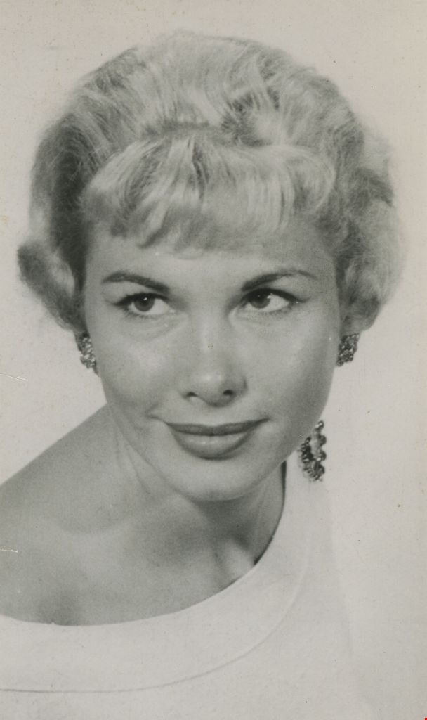
Lorraine Murison
https://search.heritageburnaby.ca/link/archivedescription45842
- Repository
- City of Burnaby Archives
- Date
- July 1958
- Collection/Fonds
- Columbian Newspaper collection
- Description Level
- Item
- Physical Description
- 1 photograph : b&w ; 13.5 x 9.5 cm
- Scope and Content
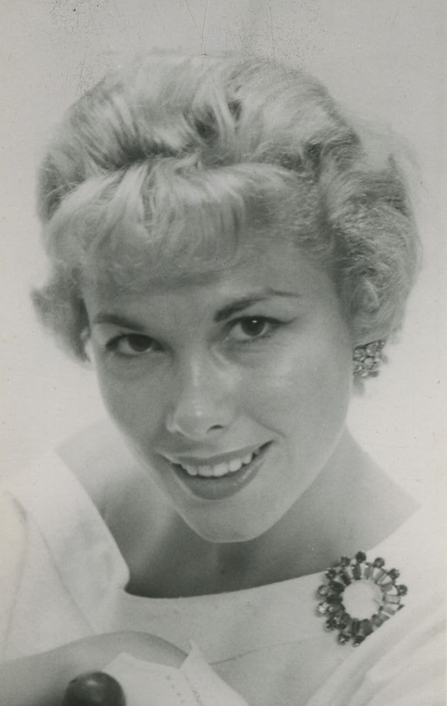
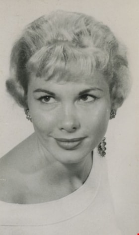
- Photograph of Columbian newspaper fashion columnist Lorraine Murison with a large broach pinned to the collar of her shirt. (According to newspaper articles that accompany this photograph, her surname is sometimes spelt Muirson, and sometimes Murison).
- Repository
- City of Burnaby Archives
- Date
- July 1958
- Collection/Fonds
- Columbian Newspaper collection
- Physical Description
- 1 photograph : b&w ; 13.5 x 9.5 cm
- Description Level
- Item
- Record No.
- 480-736
- Access Restriction
- No restrictions
- Reproduction Restriction
- Reproduce for fair dealing purposes only
- Accession Number
- 2003-02
- Scope and Content
- Photograph of Columbian newspaper fashion columnist Lorraine Murison with a large broach pinned to the collar of her shirt. (According to newspaper articles that accompany this photograph, her surname is sometimes spelt Muirson, and sometimes Murison).
- Media Type
- Photograph
- Photographer
- King, Basil
- Notes
- Title based on contents of photograph
Images
Lorraine Murison
https://search.heritageburnaby.ca/link/archivedescription45843
- Repository
- City of Burnaby Archives
- Date
- July 1958, published July 8, 1958
- Collection/Fonds
- Columbian Newspaper collection
- Description Level
- Item
- Physical Description
- 1 photograph : b&w ; 13.5 x 9.5 cm
- Scope and Content
- Photograph of Columbian newspaper fashion columnist Lorraine Murison with a large broach pinned to the collar of her shirt. (According to newspaper articles that accompany this photograph, her surname is sometimes spelt Muirson, and sometimes Murison).
- Repository
- City of Burnaby Archives
- Date
- July 1958, published July 8, 1958
- Collection/Fonds
- Columbian Newspaper collection
- Physical Description
- 1 photograph : b&w ; 13.5 x 9.5 cm
- Description Level
- Item
- Record No.
- 480-737
- Access Restriction
- No restrictions
- Reproduction Restriction
- No restrictions
- Accession Number
- 2003-02
- Scope and Content
- Photograph of Columbian newspaper fashion columnist Lorraine Murison with a large broach pinned to the collar of her shirt. (According to newspaper articles that accompany this photograph, her surname is sometimes spelt Muirson, and sometimes Murison).
- Media Type
- Photograph
- Photographer
- King, Basil
- Notes
- Title based on contents of photograph
Images

Olive Farrington Barber
https://search.heritageburnaby.ca/link/archivedescription35225
- Repository
- City of Burnaby Archives
- Date
- 1928 (date of original), copied 1986
- Collection/Fonds
- Burnaby Historical Society fonds
- Description Level
- Item
- Physical Description
- 1 photograph : b&w ; 12.7 x 17.8 cm print
- Scope and Content
- Photograph of Olive Farrington Barber in front of the Farrington brothers' chicken shed. Brothers Thomas Farrington and Richard Farrington founded Wheat Sheaf Poultry Ranch in 1919. It was located at 3907 Chesham Avenue (later renumbered 5384 Chesham Avenue).
- Repository
- City of Burnaby Archives
- Date
- 1928 (date of original), copied 1986
- Collection/Fonds
- Burnaby Historical Society fonds
- Subseries
- Pioneer Tales subseries
- Physical Description
- 1 photograph : b&w ; 12.7 x 17.8 cm print
- Description Level
- Item
- Record No.
- 204-082
- Access Restriction
- No restrictions
- Reproduction Restriction
- No known restrictions
- Accession Number
- BHS1988-03
- Scope and Content
- Photograph of Olive Farrington Barber in front of the Farrington brothers' chicken shed. Brothers Thomas Farrington and Richard Farrington founded Wheat Sheaf Poultry Ranch in 1919. It was located at 3907 Chesham Avenue (later renumbered 5384 Chesham Avenue).
- Media Type
- Photograph
- Notes
- Title based on contents of photograph
- Geographic Access
- Chesham Avenue
- Street Address
- 5384 Chesham Avenue
- Historic Neighbourhood
- Central Park (Historic Neighbourhood)
- Planning Study Area
- Garden Village Area
Images

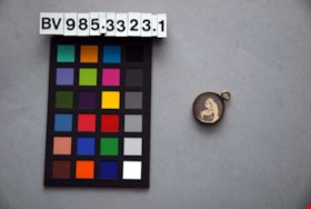
pendant
https://search.heritageburnaby.ca/link/museumartifact11409
- Repository
- Burnaby Village Museum
- Accession Code
- BV985.3323.1
- Description
- Pendant, small brass ring with picture on each side and glass in front. Portrait of Queen Victoria as a young woman on one side and older on other side. Small loop for hanging. Portraits are in sepia tones.
Images


ring
https://search.heritageburnaby.ca/link/museumartifact48591
- Repository
- Burnaby Village Museum
- Accession Code
- BV005.35.18
- Description
- Ring, high school; yellow, gold, maroon, black; writing in three black bars across front yellow panel; maroon and gold geometric shapes fan out behind it; some chips and discolouration.
- Object History
- Burnaby South High School was renamed Hugh M. Fraser High in 1941?, but was changed back to the original name a short time later. Hugh M. Fraser was appointed commissioner of the municipality of Burnaby when it was forced into receivership and at the end of 1932, after a dispute with the Provincial government about relief payments for the unemployed. A Provincial Commission stepped in to take over the governance of the city, under Hugh M. Fraser.
- Marks/Labels
- "HUGH M. / FRASER / HIGH", gold letters in three black bars across front panel
- Subjects
- Adornment
- Adornment - Jewelry
- Geographic Access
- Rumble Street
Images
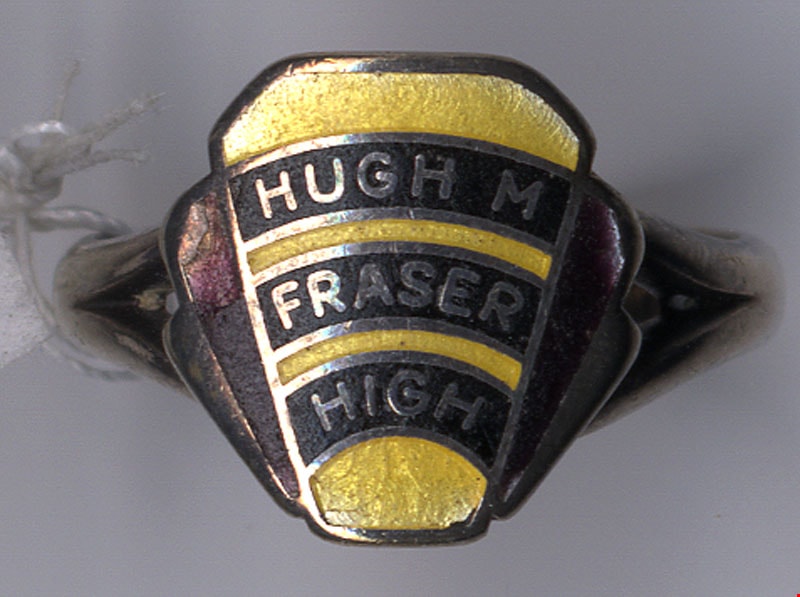
![Woman wearing jewelry, [between 1880 and 1895] thumbnail](/media/hpo/_Data/_BVM_Images/1985/1985_5886_0001_001.jpg?width=280)
Woman wearing jewelry
https://search.heritageburnaby.ca/link/museumdescription1510
- Repository
- Burnaby Village Museum
- Date
- [between 1880 and 1895]
- Collection/Fonds
- Burnaby Village Museum Photograph collection
- Description Level
- Item
- Physical Description
- 1 photograph : b&w ; 14 x 18.5 cm
- Scope and Content
- Photograph is a studio portrait of an unidentified young woman with her curly hair put up and decorated with a round hair pin in the front. She is wearing a white blouse with high neck, and is wearing a brooch shaped like a tuning fork or a wishbone and has a pendent around her neck.
- Repository
- Burnaby Village Museum
- Collection/Fonds
- Burnaby Village Museum Photograph collection
- Description Level
- Item
- Physical Description
- 1 photograph : b&w ; 14 x 18.5 cm
- Material Details
- printed on the card mount, recto, l.r. "Steele & Co./ LTD/ Winnipeg & Calgary"
- The photograph is printed in an oval shape, and mounted on a card supplied by the photo studio. There are scribbles on verso of cardboard.
- Scope and Content
- Photograph is a studio portrait of an unidentified young woman with her curly hair put up and decorated with a round hair pin in the front. She is wearing a white blouse with high neck, and is wearing a brooch shaped like a tuning fork or a wishbone and has a pendent around her neck.
- Subjects
- Adornment - Jewelry
- Clothing
- Accession Code
- BV985.5886.1
- Access Restriction
- No restrictions
- Reproduction Restriction
- No known restrictions
- Date
- [between 1880 and 1895]
- Media Type
- Photograph
- Scan Resolution
- 600
- Scan Date
- 2024-02-27
- Photographer
- Steele & Co.
- Notes
- Title based on contents of photograph
Images
![Woman wearing jewelry, [between 1880 and 1895] thumbnail](/media/hpo/_Data/_BVM_Images/1985/1985_5886_0001_001.jpg)
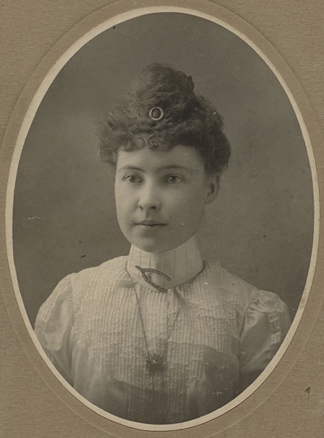
![Woman with glasses on her dress, [189-] thumbnail](/media/hpo/_Data/_BVM_Images/1983/1983_0042_0156_001.jpg?width=280)
Woman with glasses on her dress
https://search.heritageburnaby.ca/link/museumdescription416
- Repository
- Burnaby Village Museum
- Date
- [189-]
- Collection/Fonds
- Burnaby Village Museum Photograph collection
- Description Level
- Item
- Physical Description
- 1 photograph : b&w ; 15.24 x 20.32 cm oval mounted on matt 20 x 15 cm
- Scope and Content
- Photograph of an unidentified woman taken in a photographic studio. She has grey hair that is tied back, and wears turn of the century period dress, dark coloured with pleats on the chest and lace trimming at the neck. She has a brooch at her neck, and on her right chest, there is her glasses hangi…
- Repository
- Burnaby Village Museum
- Collection/Fonds
- Burnaby Village Museum Photograph collection
- Description Level
- Item
- Physical Description
- 1 photograph : b&w ; 15.24 x 20.32 cm oval mounted on matt 20 x 15 cm
- Material Details
- inscribed in pencil on the card mount, verso, u.l. "2144 Osler"
- Photograph is cut into an oval shape and mounted on a thick brown card
- Card is stained throughout
- Scope and Content
- Photograph of an unidentified woman taken in a photographic studio. She has grey hair that is tied back, and wears turn of the century period dress, dark coloured with pleats on the chest and lace trimming at the neck. She has a brooch at her neck, and on her right chest, there is her glasses hanging by a clip or a pin. She is wearing chains or rosary around her neck.
- Subjects
- Adornment - Jewelry
- Accession Code
- HV983.42.156
- Reproduction Restriction
- No known restrictions
- Date
- [189-]
- Media Type
- Photograph
- Scan Resolution
- 600
- Scan Date
- 2023-12-05
Images
![Woman with glasses on her dress, [189-] thumbnail](/media/hpo/_Data/_BVM_Images/1983/1983_0042_0156_001.jpg)
![Young woman wearing a pendant, [1923] thumbnail](/media/hpo/_Data/_BVM_Images/1984/1984_0051_0047_001.jpg?width=280)
Young woman wearing a pendant
https://search.heritageburnaby.ca/link/museumdescription265
- Repository
- Burnaby Village Museum
- Date
- [1923]
- Collection/Fonds
- Burnaby Village Museum Photograph collection
- Description Level
- Item
- Physical Description
- 1 photograph : sepia postcard ; 13.0 x 8.5 cm
- Scope and Content
- Photographic postcard of an unidentified young woman with short dark hair taken in a photographic studio. She is wearing a dress with vertical stripes, and has a pendant around her neck. There appears to be a faint outline of a face depicted in the pendant. An annotation on the back of the photogr…
- Repository
- Burnaby Village Museum
- Collection/Fonds
- Burnaby Village Museum Photograph collection
- Description Level
- Item
- Physical Description
- 1 photograph : sepia postcard ; 13.0 x 8.5 cm
- Scope and Content
- Photographic postcard of an unidentified young woman with short dark hair taken in a photographic studio. She is wearing a dress with vertical stripes, and has a pendant around her neck. There appears to be a faint outline of a face depicted in the pendant. An annotation on the back of the photograph reads: "2/23."
- Accession Code
- HV984.51.47
- Access Restriction
- No restrictions
- Reproduction Restriction
- No known restrictions
- Date
- [1923]
- Media Type
- Photograph
- Scan Resolution
- 600
- Scan Date
- 2023-10-10
- Notes
- Title based on contents of photograph
Images
![Young woman wearing a pendant, [1923] thumbnail](/media/hpo/_Data/_BVM_Images/1984/1984_0051_0047_001.jpg)