Narrow Results By
Subject
- Archeological Specimen 1
- Buildings - Religious - Churches 5
- Buildings - Residential - Houses 2
- Geographic Features - Gardens 2
- Holidays - Easter 1
- Indigenous peoples - British Columbia 1
- Persons 1
- Persons - Children 1
- Recreational Activities 1
- Woodworking Tools and Equipment 1
- Woodworking Tools and Equipment - Maul 1

Schou Street School
https://search.heritageburnaby.ca/link/landmark637
- Repository
- Burnaby Heritage Planning
- Description
- School building.
- Associated Dates
- 1914
- Street View URL
- Google Maps Street View
- Repository
- Burnaby Heritage Planning
- Geographic Access
- Norfolk Street
- Associated Dates
- 1914
- Description
- School building.
- Heritage Value
- This school was built to replace tents and temporary buildings that had previously been used for the local children of the Broadview neighbourhood. The site was donated to the School Board in 1911 by the real estate firm of Leibly & Blumer in anticipation of increased settlement in the district. The school was named after the street, which had been named after Nicolai Schou, Burnaby’s second Reeve. Originally designed in the Arts and Crafts style, the character of the school was altered in 1964 when its original siding was covered in stucco and the windows were replaced, but has retained its original form and massing, including its front gabled entrance with recessed doorway and twinned square columns. Of special note is the name of the school above the front entry.This school was designed by Joseph H. Bowman (1864-1943), a specialist in school buildings, who was retained as the school board architect for South Vancouver and Burnaby. One of his first designs for Burnaby was a utilitarian two-storey school that could be built with two classrooms and later expanded to eight rooms as the district’s school population grew; five schools from this design were built in 1908, and then four others in modified versions between 1910-16, including this school.
- Locality
- Broadview
- Historic Neighbourhood
- Broadview (Historic Neighbourhood)
- Planning Study Area
- Cascade-Schou Area
- Architect
- Joseph H. Bowman
- Area
- 7660.46
- Contributing Resource
- Building
- Street Address
- 4054 Norfolk Street
- Street View URL
- Google Maps Street View
Images


5190 Norfolk St
https://search.heritageburnaby.ca/link/archivedescription93756
- Repository
- City of Burnaby Archives
- Date
- April 14, 1992
- Collection/Fonds
- Grover, Elliott & Co. Ltd. fonds
- Description Level
- File
- Physical Description
- 25 photographs : col. negatives ; 35 mm
- Scope and Content
- Photographs of the exterior of the Royal Oak Baptist Church located at 5190 Norfolk Street.
- Repository
- City of Burnaby Archives
- Date
- April 14, 1992
- Collection/Fonds
- Grover, Elliott & Co. Ltd. fonds
- Physical Description
- 25 photographs : col. negatives ; 35 mm
- Description Level
- File
- Record No.
- 622-041
- Access Restriction
- No restrictions
- Reproduction Restriction
- No restrictions
- Accession Number
- 2017-39
- Scope and Content
- Photographs of the exterior of the Royal Oak Baptist Church located at 5190 Norfolk Street.
- Subjects
- Buildings - Religious - Churches
- Media Type
- Photograph
- Photographer
- Young, Richard
- Notes
- Transcribed title
- Title transcribed from envelope photographs were originally housed in
- File no. 92-167-B
- Geographic Access
- Norfolk Street
- Street Address
- 5190 Norfolk Street
- Planning Study Area
- Douglas-Gilpin Area

Altar at St. Andrew's Anglican Church
https://search.heritageburnaby.ca/link/archivedescription38248
- Repository
- City of Burnaby Archives
- Date
- 1924
- Collection/Fonds
- Burnaby Historical Society fonds
- Description Level
- Item
- Physical Description
- 1 photograph : b&w ; 9 x 12.5 cm
- Scope and Content
- Photograph of the altar at St. Andrew's Anglican Church, prepared for Easter Sunday.
- Repository
- City of Burnaby Archives
- Date
- 1924
- Collection/Fonds
- Burnaby Historical Society fonds
- Subseries
- Margaret McCallum subseries
- Physical Description
- 1 photograph : b&w ; 9 x 12.5 cm
- Description Level
- Item
- Record No.
- 375-009
- Access Restriction
- No restrictions
- Reproduction Restriction
- No known restrictions
- Accession Number
- BHS1986-42
- Scope and Content
- Photograph of the altar at St. Andrew's Anglican Church, prepared for Easter Sunday.
- Media Type
- Photograph
- Notes
- Title based on contents of photograph.
- Geographic Access
- Gilmore Avenue
- Norfolk Street
- Historic Neighbourhood
- Broadview (Historic Neighbourhood)
- Planning Study Area
- Cascade-Schou Area
Images

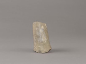
hand maul
https://search.heritageburnaby.ca/link/museumartifact44533
- Repository
- Burnaby Village Museum
- Accession Code
- BV002.37.6
- Description
- Hand maul, stone; fragment, no top.
- Object History
- Donor's father found the maul in 1946-1947 when excavating a lot at 4203 Norfolk Street. The lot was kitty corner to Schou Street School.
- Subjects
- Persons
- Indigenous peoples - British Columbia
- Woodworking Tools and Equipment
- Woodworking Tools and Equipment - Maul
- Archeological Specimen
- Geographic Access
- Norfolk Street
Images

Documents
Interview with Bob Lowe 2005 - Track 1
https://search.heritageburnaby.ca/link/museumdescription4493
- Repository
- Burnaby Village Museum
- Date
- 1930-1949 (interview content), interviewed May 2005
- Collection/Fonds
- Burnaby Village Museum fonds
- Description Level
- Item
- Physical Description
- 1 sound recording (mp3) (0:04:56 min)
- Scope and Content
- Track 1: This portion of the recording pertains to Bob’s school activities, recreation, responsibilities, and his jobs. Bob grew up in the area of Central Burnaby known as Skunk Hollow, and talks of living near Norfolk and Douglas Road in his early childhood, and then on Government Road. He recalls…
- Repository
- Burnaby Village Museum
- Collection/Fonds
- Burnaby Village Museum fonds
- Series
- Museum Oral Histories series
- Subseries
- Growing Up in Burnaby subseries
- Description Level
- Item
- Physical Description
- 1 sound recording (mp3) (0:04:56 min)
- Material Details
- Interviewer: Tom Gooden Interviewee: Bob Lowe Date of interview: May 2005 Total Number of Tracks: 6 Total length of all Tracks: 0:43:36
- Scope and Content
- Track 1: This portion of the recording pertains to Bob’s school activities, recreation, responsibilities, and his jobs. Bob grew up in the area of Central Burnaby known as Skunk Hollow, and talks of living near Norfolk and Douglas Road in his early childhood, and then on Government Road. He recalls attending Douglas Road School and Burnaby South High School. Bob describes his extracurricular activities in school, organized and informal. He mentions the games he played with his friends. Bob discusses his family chores, and his first job, which was a newspaper route for the Vancouver Province. He describes his later jobs, one at Forest Lawn Memorial Park, working for Mr. Arnold, and then for Mr. Robertson at Burnaby Lake Nurseries.
- History
- Recording of an interview with Robert "Bob" Lowe recording by Tom Gooden in 2005. This recording was completed for an exhibit, Growing Up in Burnaby, for the Burnaby Village Museum. Major themes discussed are growing up in Burnaby in the 1930s and 40s.
- Creator
- Burnaby Village Museum
- Subjects
- Persons - Children
- Geographic Access
- Norfolk Street
- Douglas Road
- Government Road
- Accession Code
- BV017.45.6
- Access Restriction
- No restrictions
- Reproduction Restriction
- May be restricted by third party rights
- Date
- 1930-1949 (interview content), interviewed May 2005
- Media Type
- Sound Recording
- Notes
- Title based on content of item
Audio Tracks
Interview with Bob Lowe 2005 - Track 1, 1930-1949 (interview content), interviewed May 2005
Interview with Bob Lowe 2005 - Track 1, 1930-1949 (interview content), interviewed May 2005
https://search.heritageburnaby.ca/media/hpo/_Data/_BVM_Sound_Recordings/Oral_Histories/2017_0045_0006_001.mp3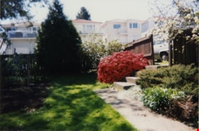
Looking south from 5496 Dominion Street
https://search.heritageburnaby.ca/link/archivedescription91865
- Repository
- City of Burnaby Archives
- Date
- April 1998
- Collection/Fonds
- Small family fonds
- Description Level
- Item
- Physical Description
- 1 photograph : col. ; 10 cm x 15 cm
- Scope and Content
- Photograph of the backyard at 5496 Dominion Street, looking south with the houses on Norfolk Street visible above the fence. These houses were built in the 1980s and 1990s following the rezoning of the properties.
- Repository
- City of Burnaby Archives
- Date
- April 1998
- Collection/Fonds
- Small family fonds
- Physical Description
- 1 photograph : col. ; 10 cm x 15 cm
- Description Level
- Item
- Record No.
- 620-046
- Access Restriction
- No restrictions
- Reproduction Restriction
- No reproduction permitted
- Accession Number
- 2017-01
- Scope and Content
- Photograph of the backyard at 5496 Dominion Street, looking south with the houses on Norfolk Street visible above the fence. These houses were built in the 1980s and 1990s following the rezoning of the properties.
- Media Type
- Photograph
- Notes
- Transcribed title
- Title transcribed from donor's notes
- Note in blue ink on verso of photograph reads: "P9"
- Note in black ink on verso of photograph reads: "April 1998 / 5496 Dominion St"
- Geographic Access
- Norfolk Street
- Street Address
- 5496 Dominion Street
- Historic Neighbourhood
- Burnaby Lake (Historic Neighbourhood)
- Planning Study Area
- Ardingley-Sprott Area
Images
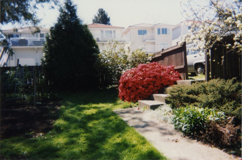

Looking west from back yard of 5496 Dominion Street
https://search.heritageburnaby.ca/link/archivedescription91866
- Repository
- City of Burnaby Archives
- Date
- April 1, 2015
- Collection/Fonds
- Small family fonds
- Description Level
- Item
- Physical Description
- 1 photograph : col. copy print ; 10 cm x 15 cm
- Scope and Content
- Photograph of the backyard at 5496 Dominion Street, looking west, with the houses on Norfolk Street (left) and Dominion Street (right) visible in the background.
- Repository
- City of Burnaby Archives
- Date
- April 1, 2015
- Collection/Fonds
- Small family fonds
- Physical Description
- 1 photograph : col. copy print ; 10 cm x 15 cm
- Description Level
- Item
- Record No.
- 620-047
- Access Restriction
- No restrictions
- Reproduction Restriction
- No reproduction permitted
- Accession Number
- 2017-01
- Scope and Content
- Photograph of the backyard at 5496 Dominion Street, looking west, with the houses on Norfolk Street (left) and Dominion Street (right) visible in the background.
- Media Type
- Photograph
- Notes
- Transcribed title
- Title transcribed from donor's notes
- Note in blue ink on verso of photograph reads: "P.10"
- Note in black ink on verso of photograph reads: "April 1, 2015"
- Geographic Access
- Dominion Street
- Norfolk Street
- Street Address
- 5496 Dominion Street
- Historic Neighbourhood
- Burnaby Lake (Historic Neighbourhood)
- Planning Study Area
- Ardingley-Sprott Area
Images

![Soap box race cars, [1939] (date of original), digitally copied 2012 thumbnail](/media/hpo/_Data/_Archives_Images/_Unrestricted/540/549-041.jpg?width=280)
Soap box race cars
https://search.heritageburnaby.ca/link/archivedescription75143
- Repository
- City of Burnaby Archives
- Date
- [1939] (date of original), digitally copied 2012
- Collection/Fonds
- Community Heritage Commission Special Projects fonds
- Description Level
- Item
- Physical Description
- 1 photograph (jpeg) : col. ; 300ppi
- Scope and Content
- Photograph of three boys on their soap box race cars at Norfolk Street near Royal Oak. Robert "Bob" Lowe is the child in the middle.
- Repository
- City of Burnaby Archives
- Date
- [1939] (date of original), digitally copied 2012
- Collection/Fonds
- Community Heritage Commission Special Projects fonds
- Physical Description
- 1 photograph (jpeg) : col. ; 300ppi
- Description Level
- Item
- Record No.
- 549-041
- Access Restriction
- No restrictions
- Reproduction Restriction
- No known restrictions
- Accession Number
- 2012-30
- Scope and Content
- Photograph of three boys on their soap box race cars at Norfolk Street near Royal Oak. Robert "Bob" Lowe is the child in the middle.
- Subjects
- Recreational Activities
- Names
- Lowe, Robert "Bob"
- Media Type
- Photograph
- Notes
- Title based on contents of photograph
- Geographic Access
- Norfolk Street
- Historic Neighbourhood
- Burnaby Lake (Historic Neighbourhood)
Images
![Soap box race cars, [1939] (date of original), digitally copied 2012 thumbnail](/media/hpo/_Data/_Archives_Images/_Unrestricted/540/549-041.jpg)

St. Andrews Anglican Church
https://search.heritageburnaby.ca/link/archivedescription38247
- Repository
- City of Burnaby Archives
- Date
- 1924
- Collection/Fonds
- Burnaby Historical Society fonds
- Description Level
- Item
- Physical Description
- 1 photograph : b&w ; 9 x 12.4 cm
- Scope and Content
- Photograph of the exterior of St. Andrew's Anglican Church built primarily by volunteer labour.
- Repository
- City of Burnaby Archives
- Date
- 1924
- Collection/Fonds
- Burnaby Historical Society fonds
- Subseries
- Margaret McCallum subseries
- Physical Description
- 1 photograph : b&w ; 9 x 12.4 cm
- Description Level
- Item
- Record No.
- 375-008
- Access Restriction
- No restrictions
- Reproduction Restriction
- No known restrictions
- Accession Number
- BHS1986-42
- Scope and Content
- Photograph of the exterior of St. Andrew's Anglican Church built primarily by volunteer labour.
- Subjects
- Buildings - Religious - Churches
- Media Type
- Photograph
- Notes
- Title based on contents of photograph
- Geographic Access
- Norfolk Street
- Gilmore Avenue
- Historic Neighbourhood
- Broadview (Historic Neighbourhood)
- Planning Study Area
- Cascade-Schou Area
Images

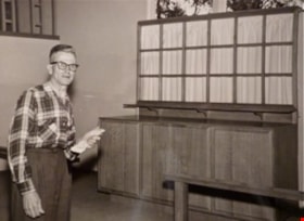
William Myers at St Andrews altar
https://search.heritageburnaby.ca/link/archivedescription88373
- Repository
- City of Burnaby Archives
- Date
- 1961 (date of original)
- Collection/Fonds
- Elaine A. Myers fonds
- Description Level
- Item
- Physical Description
- 1 photograph (jpeg) : sepia ; 96 dpi
- Scope and Content
- Photograph of Elaine's father, William Myers next to the the altar of St. Andrews Church that he built.
- Repository
- City of Burnaby Archives
- Date
- 1961 (date of original)
- Collection/Fonds
- Elaine A. Myers fonds
- Physical Description
- 1 photograph (jpeg) : sepia ; 96 dpi
- Material Details
- Jpeg is a copy created by the donor of a sepia original
- Description Level
- Item
- Record No.
- 580-003
- Access Restriction
- No restrictions
- Reproduction Restriction
- No restrictions
- Accession Number
- 2013-26
- Scope and Content
- Photograph of Elaine's father, William Myers next to the the altar of St. Andrews Church that he built.
- Subjects
- Buildings - Religious - Churches
- Media Type
- Photograph
- Notes
- Title based on contents of photograph
- Geographic Access
- Norfolk Street
- Gilmore Avenue
- Historic Neighbourhood
- Broadview (Historic Neighbourhood)
- Planning Study Area
- Cascade-Schou Area
Images
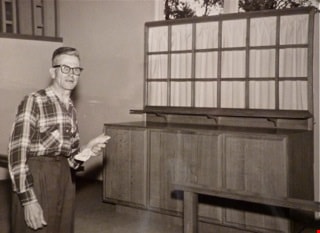

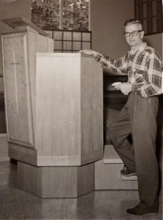
William Myers at St. Andrews pulpit
https://search.heritageburnaby.ca/link/archivedescription88374
- Repository
- City of Burnaby Archives
- Date
- 1961 (date of original)
- Collection/Fonds
- Elaine A. Myers fonds
- Description Level
- Item
- Physical Description
- 1 photograph (jpeg) : sepia ; 96 dpi
- Scope and Content
- Photograph of Elaine's father, William Myers next to the pulpit of St. Andrews Church that he built.
- Repository
- City of Burnaby Archives
- Date
- 1961 (date of original)
- Collection/Fonds
- Elaine A. Myers fonds
- Physical Description
- 1 photograph (jpeg) : sepia ; 96 dpi
- Material Details
- Jpeg is a copy created by the donor of a sepia original
- Description Level
- Item
- Record No.
- 580-004
- Access Restriction
- No restrictions
- Reproduction Restriction
- No restrictions
- Accession Number
- 2013-26
- Scope and Content
- Photograph of Elaine's father, William Myers next to the pulpit of St. Andrews Church that he built.
- Subjects
- Buildings - Religious - Churches
- Media Type
- Photograph
- Notes
- Title based on contents of photograph
- Geographic Access
- Norfolk Street
- Gilmore Avenue
- Historic Neighbourhood
- Broadview (Historic Neighbourhood)
- Planning Study Area
- Cascade-Schou Area
Images