Narrow Results By
![Valleyview Community Centre May Queen, [1940] thumbnail](/media/hpo/_Data/_Archives_Images/_Unrestricted/001/009-006.jpg?width=280)
Valleyview Community Centre May Queen
https://search.heritageburnaby.ca/link/archivedescription34071
- Repository
- City of Burnaby Archives
- Date
- [1940]
- Collection/Fonds
- Burnaby Historical Society fonds
- Description Level
- Item
- Physical Description
- 1 photograph : b&w ; 9.7 x 12.9 cm
- Scope and Content
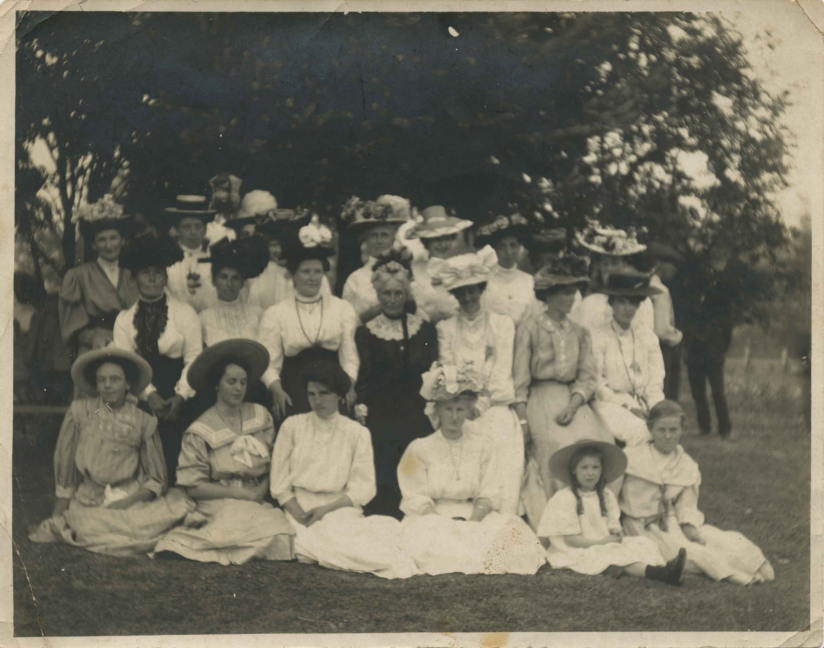
- Photograph of the Valleyview Community Centre May day celebrations. The May Queen and her suite are seated with three men and a woman standing behind them. Identified are (back row, l to r) MLA Ernie Winch, unknown, Burnaby Reeve Geroge Morrison and unknown woman. The Valleyview Community Centre …
- Repository
- City of Burnaby Archives
- Date
- [1940]
- Collection/Fonds
- Burnaby Historical Society fonds
- Subseries
- Photographs subseries
- Physical Description
- 1 photograph : b&w ; 9.7 x 12.9 cm
- Description Level
- Item
- Record No.
- 009-006
- Access Restriction
- No restrictions
- Reproduction Restriction
- No known restrictions
- Accession Number
- BHS2007-04
- Scope and Content
- Photograph of the Valleyview Community Centre May day celebrations. The May Queen and her suite are seated with three men and a woman standing behind them. Identified are (back row, l to r) MLA Ernie Winch, unknown, Burnaby Reeve Geroge Morrison and unknown woman. The Valleyview Community Centre was located at 4050 Grandview-Douglas Highway (later renumbered and renamed 4949 Canada Way).
- Subjects
- Events - May Day
- Media Type
- Photograph
- Notes
- Title based on contents of photograph
- Geographic Access
- Canada Way
- Street Address
- 4949 Canada Way
- Historic Neighbourhood
- Burnaby Lake (Historic Neighbourhood)
- Planning Study Area
- Morley-Buckingham Area
Images
![Valleyview Community Centre May Queen, [1940] thumbnail](/media/hpo/_Data/_Archives_Images/_Unrestricted/001/009-006.jpg)
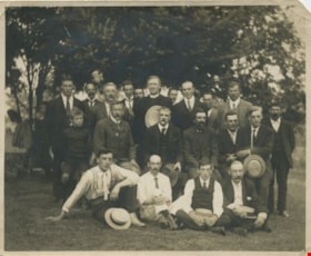
Burnaby Lake residents
https://search.heritageburnaby.ca/link/archivedescription34058
- Repository
- City of Burnaby Archives
- Date
- 1912
- Collection/Fonds
- Burnaby Historical Society fonds
- Description Level
- Item
- Physical Description
- 1 photograph : b&w ; 9.5 x 11.6 cm
- Scope and Content
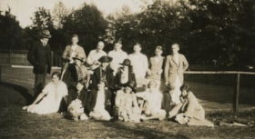
- Photograph of a group of male Burnaby Lake residents posed outside near Deer Lake Drive. Identified, standing: B.R. Hill (3rd from left), Rev. D. Dunlop (6th from left), Harry Ramsay (8th from left), Louis "Edgar" Sprott (9th from left), and George Every-Clayton (10th from left). Sitting on bench…
- Repository
- City of Burnaby Archives
- Date
- 1912
- Collection/Fonds
- Burnaby Historical Society fonds
- Subseries
- Photographs subseries
- Physical Description
- 1 photograph : b&w ; 9.5 x 11.6 cm
- Description Level
- Item
- Record No.
- 003-001
- Access Restriction
- No restrictions
- Reproduction Restriction
- No known restrictions
- Accession Number
- BHS2007-04
- Scope and Content
- Photograph of a group of male Burnaby Lake residents posed outside near Deer Lake Drive. Identified, standing: B.R. Hill (3rd from left), Rev. D. Dunlop (6th from left), Harry Ramsay (8th from left), Louis "Edgar" Sprott (9th from left), and George Every-Clayton (10th from left). Sitting on bench: [first name unknown] Clayton (1st from left), Robert Pontifex (2nd from left), Mr. Clay (4th from left), and Frank Hill (6th from left). Sitting on ground: Claude Hill (1st from left) and Percy Boyer Brown (2nd from left).
- Names
- Brown, Percy Boyer
- Every-Clayton, George
- Dunlop, Rev. D.
- Hill, Bernard R.
- Hill, Frank
- Brown, Alex
- Hill, Louis Claude "Claude"
- Pontifex, Robert
- Ramsay, Harry
- Sprott, Louis "Edgar"
- Media Type
- Photograph
- Notes
- Title based on contents of photograph
- Identification key accompanying in the envelope for photo 003-001 (labeled BHS 3.1)
- Geographic Access
- Deer Lake
- Deer Lake Avenue
- Historic Neighbourhood
- Vancouver Heights (Historic Neighbourhood)
- Burnaby Lake (Historic Neighbourhood)
- Planning Study Area
- Douglas-Gilpin Area
Images
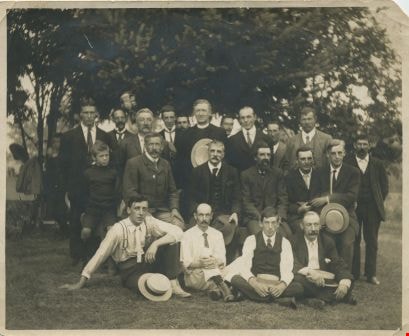
Burnaby Lake residents
https://search.heritageburnaby.ca/link/archivedescription34059
- Repository
- City of Burnaby Archives
- Date
- 1912
- Collection/Fonds
- Burnaby Historical Society fonds
- Description Level
- Item
- Physical Description
- 1 photograph : b&w ; 9.5 x 12.1 cm
- Scope and Content
- Photograph of a group of female Burnaby Lake residents posed outside near Deer Lake Drive. Identified, standing: Mrs. C.R. Gordon (5th from left, behind seated woman in black) and Mrs. F.J. Peers (7th from left). Sitting in middle: Miss K. Schou (1st from left), Mrs. Featherstonaugh [?] (3rd from…
- Repository
- City of Burnaby Archives
- Date
- 1912
- Collection/Fonds
- Burnaby Historical Society fonds
- Subseries
- Photographs subseries
- Physical Description
- 1 photograph : b&w ; 9.5 x 12.1 cm
- Description Level
- Item
- Record No.
- 003-002
- Access Restriction
- No restrictions
- Reproduction Restriction
- No known restrictions
- Accession Number
- BHS2007-04
- Scope and Content
- Photograph of a group of female Burnaby Lake residents posed outside near Deer Lake Drive. Identified, standing: Mrs. C.R. Gordon (5th from left, behind seated woman in black) and Mrs. F.J. Peers (7th from left). Sitting in middle: Miss K. Schou (1st from left), Mrs. Featherstonaugh [?] (3rd from left), Mrs. J. Woodward (4th from left, in black), and Mrs. Dunlop (5th from left). Seated on ground: P. Featherstonhaugh (2nd from left), F. Featherstonaugh (3rd from left), Phoebe Buker (4th from left), [Elizabeth?] Sprott (5th from left), and [first name unknown] Clayton (6th from left).
- Names
- Buker, Phoebe
- Fetherstonhaugh, F.
- Fetherstonhaugh, Phyllis
- Peers, Francis J.
- Sprott, Elizabeth
- Woodward, Julia
- Media Type
- Photograph
- Notes
- Title based on contents of photograph
- Identification key accompanying in the envelope for photo 003-001 (labeled BHS 3.1)
- Geographic Access
- Deer Lake
- Deer Lake Avenue
- Historic Neighbourhood
- Burnaby Lake (Historic Neighbourhood)
- Planning Study Area
- Douglas-Gilpin Area
Images
Ian Gordon at Douglas Road School
https://search.heritageburnaby.ca/link/archivedescription38644
- Repository
- City of Burnaby Archives
- Date
- 1956
- Collection/Fonds
- Burnaby Historical Society fonds
- Description Level
- Item
- Physical Description
- 1 photograph : b&w ; 10 x 15 cm
- Scope and Content
- Photograph of Ian Gordon (left) and another unknown boy playing on the grounds outside Douglas Road School.
- Repository
- City of Burnaby Archives
- Date
- 1956
- Collection/Fonds
- Burnaby Historical Society fonds
- Subseries
- Douglas Road School subseries
- Physical Description
- 1 photograph : b&w ; 10 x 15 cm
- Description Level
- Item
- Record No.
- 471-005
- Access Restriction
- No restrictions
- Reproduction Restriction
- Reproduce for fair dealing purposes only
- Accession Number
- BHS2005-3
- Scope and Content
- Photograph of Ian Gordon (left) and another unknown boy playing on the grounds outside Douglas Road School.
- Media Type
- Photograph
- Photographer
- Gordon, Ethel
- Notes
- Title based on contents of photograph
- Geographic Access
- Canada Way
- Street Address
- 4861 Canada Way
- Historic Neighbourhood
- Burnaby Lake (Historic Neighbourhood)
- Planning Study Area
- Douglas-Gilpin Area
Images

Looking south from Bernard Hill's house
https://search.heritageburnaby.ca/link/archivedescription39527
- Repository
- City of Burnaby Archives
- Date
- 1906
- Collection/Fonds
- Peers Family and Hill Family fonds
- Description Level
- Item
- Physical Description
- 1 photograph : b&w ; 11.8 x 17 cm on page 21.5 x 28 cm (pasted in album)
- Scope and Content
- Photograph of the fields and farmland looking southeast from the home of Bernard Hill down Douglas Road towards Deer Lake Brook. In the foreground view can be seen what is the present-day Kensington Avenue freeway entrance and No. 1 Firehall site on Sperling Avenue. The cabin that can be seen to …
- Repository
- City of Burnaby Archives
- Date
- 1906
- Collection/Fonds
- Peers Family and Hill Family fonds
- Physical Description
- 1 photograph : b&w ; 11.8 x 17 cm on page 21.5 x 28 cm (pasted in album)
- Description Level
- Item
- Record No.
- 477-846
- Access Restriction
- No restrictions
- Reproduction Restriction
- No known restrictions
- Accession Number
- 2007-12
- Scope and Content
- Photograph of the fields and farmland looking southeast from the home of Bernard Hill down Douglas Road towards Deer Lake Brook. In the foreground view can be seen what is the present-day Kensington Avenue freeway entrance and No. 1 Firehall site on Sperling Avenue. The cabin that can be seen to the left in the background is an unknown residence further along Douglas Road near Rayside Drive and the cabin that is just visible in the centre background of the photograph (between treeline split) belonged to Mr. Nicholson. It was later torn down when Bernard Hill's brother Claude Hill built his home, Broadview at that location. To the extreme right of the picture on the opposite side of Douglas Road is the property of Claude Hill's first Burnaby home also known as Brookfield (the current location of the Burnaby Village Museum).
- Subjects
- Agriculture - Farms
- Media Type
- Photograph
- Notes
- Title based on caption accompanying photograph
- Geographic Access
- Douglas Road
- Canada Way
- Deer Lake Brook
- Street Address
- 4990 Canada Way
- Historic Neighbourhood
- Burnaby Lake (Historic Neighbourhood)
- Planning Study Area
- Douglas-Gilpin Area
Images


Lubbock's farm
https://search.heritageburnaby.ca/link/archivedescription36517
- Repository
- City of Burnaby Archives
- Date
- 1977
- Collection/Fonds
- Burnaby Historical Society fonds
- Description Level
- Item
- Physical Description
- 1 photograph : col. ; 9 x 8.5 cm
- Scope and Content
- Copyright holder and creator are unknown. Copyright expires in 2053.
- Repository
- City of Burnaby Archives
- Date
- 1977
- Collection/Fonds
- Burnaby Historical Society fonds
- Subseries
- Lubbock family subseries
- Physical Description
- 1 photograph : col. ; 9 x 8.5 cm
- Description Level
- Item
- Record No.
- 289-006
- Access Restriction
- No restrictions
- Reproduction Restriction
- Reproduce for fair dealing purposes only
- Accession Number
- BHS1992-24
- Scope and Content
- Copyright holder and creator are unknown. Copyright expires in 2053.
- Media Type
- Photograph
- Notes
- Title based on contents of photograph
- Geographic Access
- Grandview Highway
- Canada Way
- Burris Street
- Street Address
- 7803 Burris Street
- Historic Neighbourhood
- Burnaby Lake (Historic Neighbourhood)
- Planning Study Area
- Morley-Buckingham Area
Images

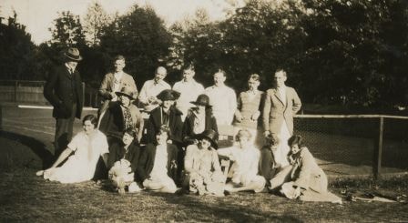
On the tennis court
https://search.heritageburnaby.ca/link/archivedescription39220
- Repository
- City of Burnaby Archives
- Date
- 1926
- Collection/Fonds
- Peers Family and Hill Family fonds
- Description Level
- Item
- Physical Description
- 1 photograph : b&w ; 6 x 11 cm on page 24.5 x 32.5 cm (pasted in album)
- Scope and Content
- Photograph of a group on the tennis court a the home of Bob and Kitty Peers on Deer Lake Avenue. Identified are Francis J. Peers (back row third from the left, with pipe) and then next to him to the right, his sons, William John "Bob" Peers, Richard Dominic "Dick" Peers, and Geoffrey Hugh Peers. T…
- Repository
- City of Burnaby Archives
- Date
- 1926
- Collection/Fonds
- Peers Family and Hill Family fonds
- Physical Description
- 1 photograph : b&w ; 6 x 11 cm on page 24.5 x 32.5 cm (pasted in album)
- Description Level
- Item
- Record No.
- 477-539
- Access Restriction
- No restrictions
- Reproduction Restriction
- No known restrictions
- Accession Number
- 2007-12
- Scope and Content
- Photograph of a group on the tennis court a the home of Bob and Kitty Peers on Deer Lake Avenue. Identified are Francis J. Peers (back row third from the left, with pipe) and then next to him to the right, his sons, William John "Bob" Peers, Richard Dominic "Dick" Peers, and Geoffrey Hugh Peers. The rest are unknown.
- Subjects
- Sports - Tennis
- Names
- Peers, Francis J.
- Peers, Geoffrey Hugh
- Peers, Richard Dominic "Dick"
- Peers, William John "Bob"
- Media Type
- Photograph
- Notes
- Title based on caption accompanying photograph
- Geographic Access
- Deer Lake Avenue
- Street Address
- 6588 Deer Lake Avenue
- Historic Neighbourhood
- Burnaby Lake (Historic Neighbourhood)
- Planning Study Area
- Douglas-Gilpin Area
Images
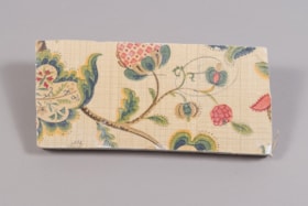
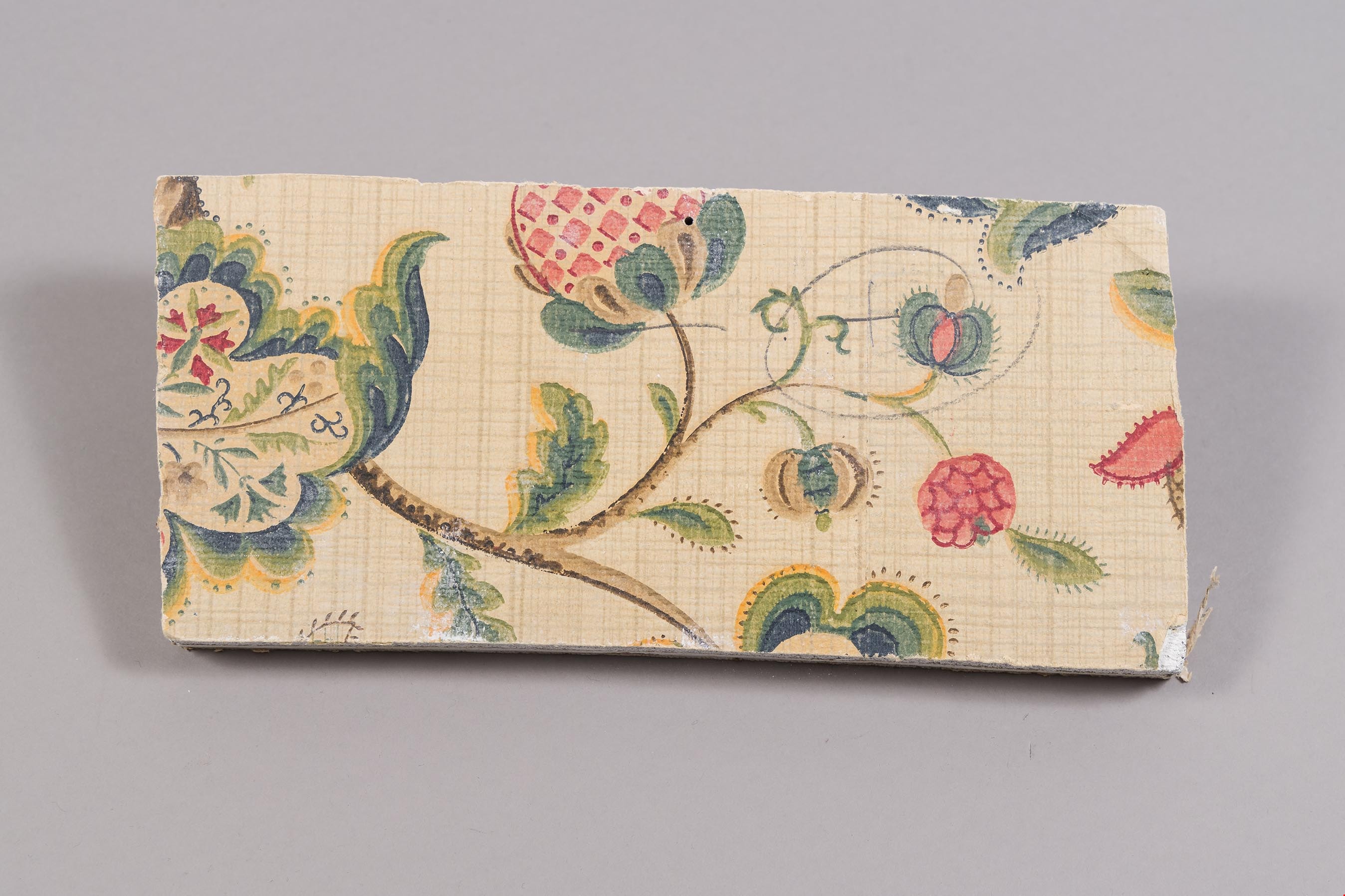
wall section
https://search.heritageburnaby.ca/link/museumartifact81703
- Repository
- Burnaby Village Museum
- Accession Code
- BV988.33.108
- Description
- A section of wall board and plaster with a flower motif wallpaper on the top surface.
- Object History
- This item was taken from Love farmhouse. It is unknown what room the fragment is from.
- Measurements
- 13 cm. X 28.5 cm X 2.5 cm thick. ( plaster 1.5 cm and wallboard 1 cm)
- Geographic Access
- Cumberland Street
- Historic Neighbourhood
- East Burnaby (Historic Neighbourhood)
Images