Narrow Results By
Subject
- Buildings - Judicial - Courthouses 1
- Buildings - Schools 2
- Geographic Features - Inlets 1
- Geographic Features - Parks 1
- Indigenous peoples - British Columbia 1
- Indigenous peoples - British Columbia - First contact with Europeans 1
- Indigenous peoples - British Columbia - Languages 1
- Indigenous peoples - Canada - Government relations 1
- Indigenous peoples - Canada - , Treatment of 1
- Officials - Aldermen and Councillors 1
- Officials - Commissioners 1
- Officials - Mayors and Reeves 3

Geoffrey & Kathleen Burnett Residence
https://search.heritageburnaby.ca/link/landmark582
- Repository
- Burnaby Heritage Planning
- Description
- Residential building.
- Associated Dates
- 1914
- Formal Recognition
- Heritage Designation, Community Heritage Register
- Street View URL
- Google Maps Street View
- Repository
- Burnaby Heritage Planning
- Geographic Access
- Canada Way
- Associated Dates
- 1914
- Formal Recognition
- Heritage Designation, Community Heritage Register
- Enactment Type
- Bylaw No. 13841
- Enactment Date
- 28/05/2018
- Description
- Residential building.
- Heritage Value
- With its long, narrow plan and hipped, cross-gabled roof, this impressive residence was designed for local surveyor and civil engineer Geoffrey Kirby Burnett, who married Kathleen Wallen (1888-1978) in 1916. It was designed by New Westminster architects R.W. Coventry Dick & Son. Beautifully conceived in the British Arts and Crafts style, it features a steeply-gabled roof over the side entry porch, with square timber columns. Other decorative details include half timbering in the gables, first storey casement windows with leaded transom lights and decorative window hoods on the side elevation.
- Locality
- Edmonds
- Historic Neighbourhood
- Edmonds (Historic Neighbourhood)
- Planning Study Area
- Richmond Park Area
- Architect
- R.W. Coventry Dick & Son
- Area
- 903.70
- Contributing Resource
- Building
- Ownership
- Private
- Street Address
- 7037 Canada Way
- Street View URL
- Google Maps Street View
Images

In the shadow by the sea : recollections of Burnaby's Barnet Village
https://search.heritageburnaby.ca/link/museumlibrary5173
- Repository
- Burnaby Village Museum
- Publication Date
- c2004
- Call Number
- 971.133 PRI Copy 2
an exceptional job in pulling the project together. Both Bianka Zein-
abova, of the Clerk's Department, and Therese Nielsen of the Planning Department assisted in
word processing and mailing. Michelle Barroca, Records and Information Officer andArilea Sill,
Archivist, retrieved documents from the City of Burnaby
- Repository
- Burnaby Village Museum
- Collection
- Digital Reference Collection
- Reference Collection
- Material Type
- Book
- ISBN
- 0969282885
- Call Number
- 971.133 PRI Copy 2
- Contributor
- Wolf, Jim
- Pride, Harry, 1925-
- Place of Publication
- Burnaby, B.C.
- Publisher
- City of Burnaby
- Publication Date
- c2004
- Physical Description
- 246 p. : ill., maps, ports. ; 28 cm.
- Library Subject (LOC)
- Burnaby (B.C.)--History
- Industries--British Columbia--Burnaby--History
- Barnet Marine Park--Burnaby, B.C.
- Geographic Access
- Barnet Road
- Burrard Inlet
- Notes
- Includes bibliographical references (p. 246) and index.
- "edited by Harry Pride and Jim Wolf"
- Copy 2 of 2
Digital Books

Barnet mill
https://search.heritageburnaby.ca/link/museumdescription15219
- Repository
- Burnaby Village Museum
- Date
- 1934 (date of original), copied 2004
- Collection/Fonds
- In the Shadow by the Sea collection
- Description Level
- Item
- Physical Description
- 1 photograph (tiff) : 300 dpi
- Scope and Content
- Photograph of the Barnet Mill on the shore of Burrard Inlet. Mill buildings including lodgings are visible.
- Repository
- Burnaby Village Museum
- Collection/Fonds
- In the Shadow by the Sea collection
- Description Level
- Item
- Physical Description
- 1 photograph (tiff) : 300 dpi
- Scope and Content
- Photograph of the Barnet Mill on the shore of Burrard Inlet. Mill buildings including lodgings are visible.
- Names
- Barnet Mill
- Geographic Access
- Burrard Inlet
- Accession Code
- BV019.32.39
- Access Restriction
- No restrictions
- Reproduction Restriction
- No known restrictions
- Date
- 1934 (date of original), copied 2004
- Media Type
- Photograph
- Historic Neighbourhood
- Barnet (Historic Neighbourhood)
- Planning Study Area
- Burnaby Mountain Area
- Notes
- Title based on contents of photograph
- Historical information provided by Burnaby Heritage Planning - Barnet Neighbourhood
Images


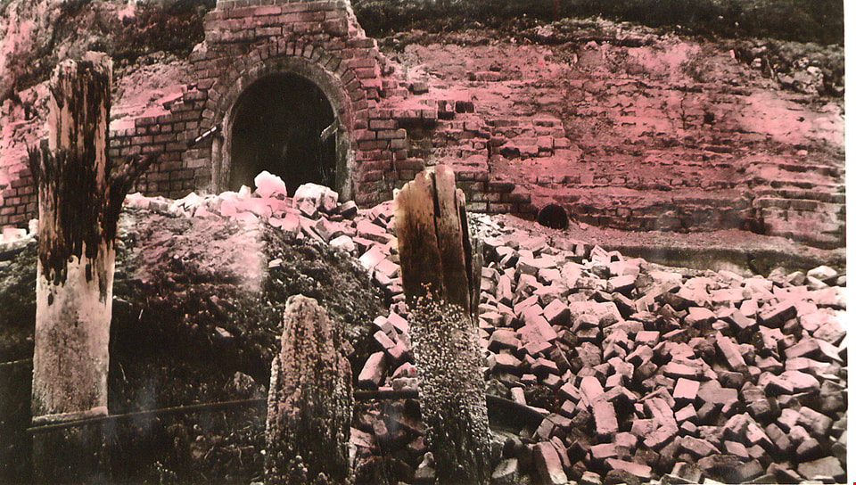
Barnet mill burner
https://search.heritageburnaby.ca/link/museumdescription15221
- Repository
- Burnaby Village Museum
- Date
- 1937 (date of original), copied 2004
- Collection/Fonds
- In the Shadow by the Sea collection
- Description Level
- Item
- Physical Description
- 1 photograph (tiff) : 300 dpi
- Scope and Content
- Photograph of the site of the old Barnet Mill burner along the shore of Burrard Inlet. Pilings and rail tracks are visible along the shore. B.C. Electric transmisson towers are visible at the top of the site. Photograph is taken from the water looking south.
- Repository
- Burnaby Village Museum
- Collection/Fonds
- In the Shadow by the Sea collection
- Description Level
- Item
- Physical Description
- 1 photograph (tiff) : 300 dpi
- Scope and Content
- Photograph of the site of the old Barnet Mill burner along the shore of Burrard Inlet. Pilings and rail tracks are visible along the shore. B.C. Electric transmisson towers are visible at the top of the site. Photograph is taken from the water looking south.
- Names
- Barnet Mill
- Geographic Access
- Burrard Inlet
- Accession Code
- BV019.32.41
- Access Restriction
- No restrictions
- Reproduction Restriction
- No known restrictions
- Date
- 1937 (date of original), copied 2004
- Media Type
- Photograph
- Historic Neighbourhood
- Barnet (Historic Neighbourhood)
- Planning Study Area
- Burnaby Mountain Area
- Notes
- Title based on contents of photograph
- Historical information provided by Burnaby Heritage Planning - Barnet Neighbourhood
Images


Bringing Visibility to the Land: A Tsleil-Waututh Perspective on Community Building
https://search.heritageburnaby.ca/link/museumdescription15665
- Repository
- Burnaby Village Museum
- Date
- 27 Apr. 2021
- Collection/Fonds
- Burnaby Village Museum fonds
- Description Level
- Item
- Physical Description
- 1 video recording (mp4) (47 min., 39 sec.) : digital, col., sd., stereo ; 29 fps
- Scope and Content
- Item consists of a video recording of a live Zoom webinar hosted by Burnaby Village Museum Curator, Jane Lemke. The webinar is titled "Bringing Visibility to the Land: A Tsleil-Waututh Perspective on Community Building" and is presented by Michelle George, Tsleil-Waututh Nation Cultural and Technic…
- Repository
- Burnaby Village Museum
- Collection/Fonds
- Burnaby Village Museum fonds
- Description Level
- Item
- Physical Description
- 1 video recording (mp4) (47 min., 39 sec.) : digital, col., sd., stereo ; 29 fps
- Material Details
- Presenters: Michelle George
- Host: Jane Lemke
- Date of Presentation: Tuesday, April 27, 7:00 pm - 8:00 pm
- Total Number of tracks: 1
- Total Length of all tracks: 47 min., 39 sec.
- Recording Device: Zoom video communication platform
- Recording Note: Film was edited from it's original recorded version (63 min., 29 sec.) to edited version (47 min., 39 sec.) for public viewing on Heritage Burnaby
- Scope and Content
- Item consists of a video recording of a live Zoom webinar hosted by Burnaby Village Museum Curator, Jane Lemke. The webinar is titled "Bringing Visibility to the Land: A Tsleil-Waututh Perspective on Community Building" and is presented by Michelle George, Tsleil-Waututh Nation Cultural and Technical Specialist. The Zoom webinar is the first in a series of six "Neighbourhood Speaker series" webinars exploring a range of topics shared by Indigenous speakers and knowledge keepers that were presented and made available to the public between April 27 and May 12, 2021. The live webinar was also made available on the Burnaby Village Museum's facebook page. Community members were invited to participate by bringing questions during the interactive online sessions. In this webinar, Michelle George explores the importance of bringing Tsleil-Waututh ways of knowing/knowledge of the land to Burnaby. She grounds her talk with her experience of working with the Burnaby Village Museum on producing the Indigenous History of Burnaby Resource Guide, an award-winning illustrated educational guide. Michelle also speaks to some of the devastating experiences that the Tsleil-Waututh Nation and Indigenous Peoples have suffered since Colonial Settlement and how her Nation has begun to grow in a changing environment. In segments of her talk, Michelle refers to a map titled "Tsleil-Waututh Nation Consultation Area". Following the presentation, Michelle George answers questions from the audience that are moderated by the host, Jane Lemke.
- History
- Michelle George is a member of the Tsleil-Waututh Nation (TWN) and currently works as a Tsleil-Waututh Nation Cultural and Technical Specialist for the Treaty, Lands and Resources (TLR) Department. She participates in various projects for the TWN government and community, focusing on Tsleil-Waututh Governance and Community. The goals that she carries in her work are to make sure Tsleil-Waututh culture is included and considered in these Nation-level projects, as well as within the reviews done on external projects within the TWN Consultation area. She has been a member of both the Tsleil-Waututh Land Code Committee and Land Use Planning group. Michelle is also a First Nations Health Authority Traditional Knowledge Keeper, and a past-Elected Councilor for Tsleil-Waututh Nation. Michelle also provides guest lectures at Simon Fraser University, Langara College, and the BC Institute of Technology.
- Creator
- Burnaby Village Museum
- Subjects
- Indigenous peoples - British Columbia
- Indigenous peoples - Canada - Government relations
- Indigenous peoples - British Columbia - Languages
- Indigenous peoples - Canada - , Treatment of
- Indigenous peoples - British Columbia - First contact with Europeans
- Names
- Burnaby Village Museum
- Burnaby Public Library
- George, Michelle
- Tsleil-Waututh Nation
- George, Chief Daniel "Dan"
- Responsibility
- Lemke, Jane
- Geographic Access
- Burrard Inlet
- Accession Code
- BV021.17.1
- Access Restriction
- No restrictions
- Reproduction Restriction
- No known restrictions
- Date
- 27 Apr. 2021
- Media Type
- Moving Images
- Notes
- Title based on contents of video recording
Images

Video
Bringing Visibility to the Land: A Tsleil-Waututh Perspective on Community Building, 27 Apr. 2021
Bringing Visibility to the Land: A Tsleil-Waututh Perspective on Community Building, 27 Apr. 2021
https://search.heritageburnaby.ca/media/hpo/_Data/_BVM_Moving_Images/2021_0017_0001_002.mp4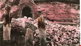
Mill burner
https://search.heritageburnaby.ca/link/museumdescription15220
- Repository
- Burnaby Village Museum
- Date
- 1937 (date of original), copied 2004
- Collection/Fonds
- In the Shadow by the Sea collection
- Description Level
- Item
- Physical Description
- 1 photograph (tiff) : 300 dpi
- Scope and Content
- Photograph of the crumbling foundation of the old Barnet Mill burner. Bricks from the former burner are piled on the shore in front of the burner entrance. Old pilings encrusted with barnacles are visible in the foreground.
- Repository
- Burnaby Village Museum
- Collection/Fonds
- In the Shadow by the Sea collection
- Description Level
- Item
- Physical Description
- 1 photograph (tiff) : 300 dpi
- Scope and Content
- Photograph of the crumbling foundation of the old Barnet Mill burner. Bricks from the former burner are piled on the shore in front of the burner entrance. Old pilings encrusted with barnacles are visible in the foreground.
- Names
- Barnet Mill
- Geographic Access
- Burrard Inlet
- Accession Code
- BV019.32.40
- Access Restriction
- No restrictions
- Reproduction Restriction
- No known restrictions
- Date
- 1937 (date of original), copied 2004
- Media Type
- Photograph
- Historic Neighbourhood
- Barnet (Historic Neighbourhood)
- Planning Study Area
- Burnaby Mountain Area
- Notes
- Title based on contents of photograph
- See page 120 of book "In the Shadow by the Sea - Recollections of Burnaby's Barnet Village". Caption with photograph reads: "The crumbling foundation of the old mill burner, 1937"
- Historical information provided by Burnaby Heritage Planning - Barnet Neighbourhood
Images

Douglas Road School site
https://search.heritageburnaby.ca/link/museumdescription11136
- Repository
- Burnaby Village Museum
- Date
- April 19, 1915
- Collection/Fonds
- Ronald G. Scobbie collection
- Description Level
- Item
- Physical Description
- 1 survey plan : blueprint on paper ; 56 x 54 cm
- Scope and Content
- Survey plan of "Douglas Road School Site / Burnaby Municipality" "Being Lot 21, of Blocks 1-5 inc. 11 & 12 of the subd. of north half of Lot 80, Group 1, New Westminster District".
- Repository
- Burnaby Village Museum
- Collection/Fonds
- Ronald G. Scobbie collection
- Description Level
- Item
- Physical Description
- 1 survey plan : blueprint on paper ; 56 x 54 cm
- Material Details
- Scale 40 feet = 1 inch
- Scope and Content
- Survey plan of "Douglas Road School Site / Burnaby Municipality" "Being Lot 21, of Blocks 1-5 inc. 11 & 12 of the subd. of north half of Lot 80, Group 1, New Westminster District".
- Creator
- McGugan, Donald Johnston
- Subjects
- Buildings - Schools
- Names
- Douglas Road School
- Responsibility
- Burnett & McGugan, Engineers and Surveyors
- Geographic Access
- Canada Way
- Street Address
- 4861 Canada Way
- Accession Code
- BV003.83.15
- Access Restriction
- No restrictions
- Reproduction Restriction
- No known restrictions
- Date
- April 19, 1915
- Media Type
- Cartographic Material
- Historic Neighbourhood
- Burnaby Lake (Historic Neighbourhood)
- Planning Study Area
- Douglas-Gilpin Area
- Scan Resolution
- 440
- Scan Date
- 22-Dec-2020
- Scale
- 100
- Notes
- Title based on contents of plan
- Note in black ink on verso of plan reads: "1747"
- Oath on plan reads: "I, D.G. McGugan..." "...and did person- ally superintend the survey..." "...completed on the 3rd day of April 1915"; signed by D.J. McGugan, notarized by "H.A. Eastman", sworn "...19th day of April 1915" "Burnett and McGugan" "B.C. Land Surveyors Etc. New Westminster, B.C.."
Images


Schou Street School site
https://search.heritageburnaby.ca/link/museumdescription11138
- Repository
- Burnaby Village Museum
- Date
- April 12, 1915
- Collection/Fonds
- Ronald G. Scobbie collection
- Description Level
- Item
- Physical Description
- 1 survey plan : blueprint on paper ; 56 x 54 cm
- Scope and Content
- Survey plan of "Schou Street School Site / Burnaby Municipality" "Being Lot 1-12 inc. of Block 47, of subd. of Blocks 8-12 and 15-49 inclusive, Lot 69, Group 1" "New Westminster District";
- Repository
- Burnaby Village Museum
- Collection/Fonds
- Ronald G. Scobbie collection
- Description Level
- Item
- Physical Description
- 1 survey plan : blueprint on paper ; 56 x 54 cm
- Material Details
- Scale 40 feet = 1 inch
- Scope and Content
- Survey plan of "Schou Street School Site / Burnaby Municipality" "Being Lot 1-12 inc. of Block 47, of subd. of Blocks 8-12 and 15-49 inclusive, Lot 69, Group 1" "New Westminster District";
- Creator
- Burnett, Geoffrey K.
- Subjects
- Buildings - Schools
- Names
- Schou Street School
- Responsibility
- Burnett & McGugan, Engineers and Surveyors
- Geographic Access
- Canada Way
- Grandview Highway
- Gilmore Avenue
- Street Address
- 4054 Norfolk Street
- Accession Code
- BV003.83.17
- Access Restriction
- No restrictions
- Reproduction Restriction
- No known restrictions
- Date
- April 12, 1915
- Media Type
- Cartographic Material
- Historic Neighbourhood
- Broadview (Historic Neighbourhood)
- Planning Study Area
- Cascade-Schou Area
- Scan Resolution
- 440
- Scan Date
- 22-Dec-2020
- Scale
- 100
- Notes
- Title based on contents of plan
- Oath on plan reads: "I, Geoffrey K. Burnett...did person- ally superintend the survey..." "...completed on the 12th day of April 1915"; signed by Geoffrey K. Burnett, notarized by "S.F. Mark", sworn "..12th day.. April 1915" "Burnett and McGugan" "B.C. Land Surveyors Etc. New Westminster, B.C.
- ."handwritten on back, "1751"
- two school buildings are shown on this blueprint, "Old School Building", "New School Building"
Images

![Protest against aerial spraying around Burnaby Lake, [2000] thumbnail](/media/hpo/_Data/_Archives_Images/_Unrestricted/535/535-2392-1.jpg?width=280)
Protest against aerial spraying around Burnaby Lake
https://search.heritageburnaby.ca/link/archivedescription96834
- Repository
- City of Burnaby Archives
- Date
- [2000]
- Collection/Fonds
- Burnaby NewsLeader photograph collection
- Description Level
- File
- Physical Description
- 2 photographs (tiff) : col.
- Scope and Content
- File contains photographs of a protest against planned aerial spraying around Burnaby Lake, at Burnaby City Hall. Photographs depict a group of protestors standing and holding signs that read "Stop Aerial Spraying" and "Live Bacteria Kills," and Martin Hanle holding up a sign in protest.
- Repository
- City of Burnaby Archives
- Date
- [2000]
- Collection/Fonds
- Burnaby NewsLeader photograph collection
- Physical Description
- 2 photographs (tiff) : col.
- Description Level
- File
- Record No.
- 535-2392
- Access Restriction
- No restrictions
- Reproduction Restriction
- No restrictions
- Accession Number
- 2018-12
- Scope and Content
- File contains photographs of a protest against planned aerial spraying around Burnaby Lake, at Burnaby City Hall. Photographs depict a group of protestors standing and holding signs that read "Stop Aerial Spraying" and "Live Bacteria Kills," and Martin Hanle holding up a sign in protest.
- Subjects
- Protests and Demonstrations
- Names
- Burnaby City Hall
- Media Type
- Photograph
- Photographer
- Bartel, Mario
- Notes
- Title based on caption
- Collected by editorial for use in a May 2000 issue of the Burnaby NewsLeader
- Caption from metadata for 535-2392-1: "A small group of protestors gather at Burnaby City Hall Monday night to express their opposition to planned aerial spraying around Burnaby Lake."
- Caption from metadata for 535-2392-2: "Martin Hanle expresses his opposition to planned aerial spraying around Burnaby Lake, at a small protest outside Burnaby City Hall on Monday."
- Geographic Access
- Canada Way
- Street Address
- 4949 Canada Way
- Historic Neighbourhood
- Burnaby Lake (Historic Neighbourhood)
- Planning Study Area
- Douglas-Gilpin Area
Images
![Protest against aerial spraying around Burnaby Lake, [2000] thumbnail](/media/hpo/_Data/_Archives_Images/_Unrestricted/535/535-2392-1.jpg)
![Derek Corrigan at Burnaby Justice Building, [2002] thumbnail](/media/hpo/_Data/_Archives_Images/_Unrestricted/535/535-2925.jpg?width=280)
Derek Corrigan at Burnaby Justice Building
https://search.heritageburnaby.ca/link/archivedescription97626
- Repository
- City of Burnaby Archives
- Date
- [2002]
- Collection/Fonds
- Burnaby NewsLeader photograph collection
- Description Level
- Item
- Physical Description
- 1 photograph (tiff) : col.
- Scope and Content
- Photograph of City of Burnaby councillor Derek Corrigan posing outside of the Burnaby Justice Building next to a sign directing to the Justice Law Courts.
- Repository
- City of Burnaby Archives
- Date
- [2002]
- Collection/Fonds
- Burnaby NewsLeader photograph collection
- Physical Description
- 1 photograph (tiff) : col.
- Description Level
- Item
- Record No.
- 535-2925
- Access Restriction
- No restrictions
- Reproduction Restriction
- No restrictions
- Accession Number
- 2018-12
- Scope and Content
- Photograph of City of Burnaby councillor Derek Corrigan posing outside of the Burnaby Justice Building next to a sign directing to the Justice Law Courts.
- Subjects
- Officials - Aldermen and Councillors
- Officials - Mayors and Reeves
- Buildings - Judicial - Courthouses
- Names
- Corrigan, Derek
- Media Type
- Photograph
- Photographer
- Bartel, Mario
- Notes
- Title based on caption
- Collected by editorial for use in a January 2002 issue of the Burnaby NewsLeader
- Caption from metadata: "Burnaby councillor, and lawyer, Derek Corrigan, is upset over the provincial government's plan to close the city's courthouse. He's leding a debate about the issue at Monday's city council meeting."
- Geographic Access
- Canada Way
- Street Address
- 4946 Canada Way
- Historic Neighbourhood
- Burnaby Lake (Historic Neighbourhood)
- Planning Study Area
- Douglas-Gilpin Area
Images
![Derek Corrigan at Burnaby Justice Building, [2002] thumbnail](/media/hpo/_Data/_Archives_Images/_Unrestricted/535/535-2925.jpg)
![Doug Drummond at Barnet Marine Park, [2003] thumbnail](/media/hpo/_Data/_Archives_Images/_Unrestricted/535/535-2277-1.jpg?width=280)
Doug Drummond at Barnet Marine Park
https://search.heritageburnaby.ca/link/archivedescription96655
- Repository
- City of Burnaby Archives
- Date
- [2003]
- Collection/Fonds
- Burnaby NewsLeader photograph collection
- Description Level
- File
- Physical Description
- 2 photographs (tiff) : col.
- Scope and Content
- File contains photographs of former City of Burnaby mayor Doug Drummond at Barnet Marine Park before is improvement and expansion. Photographs depict Drummond standing by the Inlet and walking along the waterfront path with Parks Commissioner Dan Johnston.
- Repository
- City of Burnaby Archives
- Date
- [2003]
- Collection/Fonds
- Burnaby NewsLeader photograph collection
- Physical Description
- 2 photographs (tiff) : col.
- Description Level
- File
- Record No.
- 535-2277
- Access Restriction
- No restrictions
- Reproduction Restriction
- No restrictions
- Accession Number
- 2018-12
- Scope and Content
- File contains photographs of former City of Burnaby mayor Doug Drummond at Barnet Marine Park before is improvement and expansion. Photographs depict Drummond standing by the Inlet and walking along the waterfront path with Parks Commissioner Dan Johnston.
- Subjects
- Geographic Features - Inlets
- Geographic Features - Parks
- Officials - Mayors and Reeves
- Officials - Commissioners
- Media Type
- Photograph
- Photographer
- Bartel, Mario
- Notes
- Title based on caption
- Collected by editorial for use in a March 2003 issue of the Burnaby NewsLeader
- Caption from metadata for 535-2277-1: "Former Burnaby Mayor, Doug Drummond, takes in the view from Barnet Marine Park, which will be expanded to the west, and enhanced with an interpretive centre in the old public works building and a rebuilt wharf reaching into the Burrard Inlet. Improving the park was one of Drummond's goals during his term in office."
- Caption fro metadata for 535-2277-2: "Former Burnaby mayor, Doug Drummond, and the city's parks commissioner, Dan Johnston, stroll along the path at Barnet Marine Park. The park will be expanded to the west, and enhanced with a rebuilt wharf into Burrard Inlet and an interpretive centre in the old public works building. The plan for the park will be the realization of one of Drummond's goals during his term in office."
- Geographic Access
- Barnet Marine Park
- Burrard Inlet
- Historic Neighbourhood
- Barnet (Historic Neighbourhood)
- Planning Study Area
- Burnaby Mountain Area
Images
![Doug Drummond at Barnet Marine Park, [2003] thumbnail](/media/hpo/_Data/_Archives_Images/_Unrestricted/535/535-2277-1.jpg)
![Mayor Derek Corrigan, [2003] thumbnail](/media/hpo/_Data/_Archives_Images/_Unrestricted/535/535-1732-1.jpg?width=280)
Mayor Derek Corrigan
https://search.heritageburnaby.ca/link/archivedescription95962
- Repository
- City of Burnaby Archives
- Date
- [2003]
- Collection/Fonds
- Burnaby NewsLeader photograph collection
- Description Level
- File
- Physical Description
- 2 photographs (tiff) : col.
- Scope and Content
- File contains photographs of Mayor Derek Corrigan. Photographs depict Corrigan silhouetted against his office windows at City Hall and in a close-up portrait.
- Repository
- City of Burnaby Archives
- Date
- [2003]
- Collection/Fonds
- Burnaby NewsLeader photograph collection
- Physical Description
- 2 photographs (tiff) : col.
- Description Level
- File
- Record No.
- 535-1732
- Access Restriction
- No restrictions
- Reproduction Restriction
- No restrictions
- Accession Number
- 2018-12
- Scope and Content
- File contains photographs of Mayor Derek Corrigan. Photographs depict Corrigan silhouetted against his office windows at City Hall and in a close-up portrait.
- Subjects
- Officials - Mayors and Reeves
- Media Type
- Photograph
- Photographer
- Bartel, Mario
- Notes
- Title based on caption
- Collected by editorial for use in a January 2004 issue of the Burnaby NewsLeader
- Caption from metadata for 535-1732-1: "Derek Corrigan says after a year of learning about his job as mayor, he's ready to get to work to fufill some of his goals for the City of Burnaby in the new year, his second in office."
- Caption from metadata for 535-1732-2: "Derek Corrigan talks about his plans for the City of Burnaby for the coming year."
- Geographic Access
- Canada Way
- Street Address
- 4949 Canada Way
- Historic Neighbourhood
- Burnaby Lake (Historic Neighbourhood)
- Planning Study Area
- Douglas-Gilpin Area
Images
![Mayor Derek Corrigan, [2003] thumbnail](/media/hpo/_Data/_Archives_Images/_Unrestricted/535/535-1732-1.jpg)