Narrow Results By
Subject
- Advertising Medium - Signs and Signboards 1
- Animals - Horses 1
- Buildings - Commercial 2
- Buildings - Commercial - General Stores 1
- Buildings - Commercial - Grocery Stores 1
- Buildings - Commercial - Service Stations 2
- Buildings - Commercial - Stores 2
- Buildings - Commercial - Train Stations 1
- Geographic Features - Sidewalks 1
- Land Clearing 1
- Occupations - Clerks 1
- Transportation - Trucks 1
1160 Douglas Rd
https://search.heritageburnaby.ca/link/archivedescription94327
- Repository
- City of Burnaby Archives
- Date
- December 1994
- Collection/Fonds
- Grover, Elliott & Co. Ltd. fonds
- Description Level
- File
- Physical Description
- 22 photographs : col. negatives ; 35 mm
- Scope and Content
- Photographs of the exterior of a three-storey commerical building located at 1160 Douglas Road.
- Repository
- City of Burnaby Archives
- Date
- December 1994
- Collection/Fonds
- Grover, Elliott & Co. Ltd. fonds
- Physical Description
- 22 photographs : col. negatives ; 35 mm
- Description Level
- File
- Record No.
- 622-112
- Access Restriction
- No restrictions
- Reproduction Restriction
- No restrictions
- Accession Number
- 2017-39
- Scope and Content
- Photographs of the exterior of a three-storey commerical building located at 1160 Douglas Road.
- Media Type
- Photograph
- Photographer
- Young, Richard
- Notes
- Transcribed title
- Title transcribed from envelope photographs were originally housed in
- File no. 94-424-B
- Geographic Access
- Douglas Road
- Street Address
- 1160 Douglas Road
- Historic Neighbourhood
- Vancouver Heights (Historic Neighbourhood)
- Planning Study Area
- Willingdon Heights Area
5499-5495 Regent Street / 2857 Douglas Road
https://search.heritageburnaby.ca/link/archivedescription93713
- Repository
- City of Burnaby Archives
- Date
- 1987
- Collection/Fonds
- Grover, Elliott & Co. Ltd. fonds
- Description Level
- File
- Physical Description
- 24 photographs : col. negatives ; 35 mm
- Scope and Content
- Photographs of the building exterior and loading bays of Loomis, located at 5499 and 5495 Regent Street, and of 2857 Douglas Road. 5499 and 5495 Regent Street are addresses that no longer exist; the current address is 5491 Regent Street.
- Repository
- City of Burnaby Archives
- Date
- 1987
- Collection/Fonds
- Grover, Elliott & Co. Ltd. fonds
- Physical Description
- 24 photographs : col. negatives ; 35 mm
- Description Level
- File
- Record No.
- 622-002
- Access Restriction
- No restrictions
- Reproduction Restriction
- No restrictions
- Accession Number
- 2017-39
- Scope and Content
- Photographs of the building exterior and loading bays of Loomis, located at 5499 and 5495 Regent Street, and of 2857 Douglas Road. 5499 and 5495 Regent Street are addresses that no longer exist; the current address is 5491 Regent Street.
- Media Type
- Photograph
- Notes
- Transcribed title
- Title transcribed from original print envelope
- File no. 87-133-B
- Geographic Access
- Douglas Road
- Regent Street
- Street Address
- 2857 Douglas Road
- 5491 Regent Street
- Historic Neighbourhood
- Burnaby Lake (Historic Neighbourhood)
- Planning Study Area
- Dawson-Delta Area
![Burnaby Lake Store, [1911] (date of original), copied ca. 2004 thumbnail](/media/hpo/_Data/_Archives_Images/_Unrestricted/371/475-001.jpg?width=280)
Burnaby Lake Store
https://search.heritageburnaby.ca/link/archivedescription38657
- Repository
- City of Burnaby Archives
- Date
- [1911] (date of original), copied ca. 2004
- Collection/Fonds
- Burnaby Historical Society fonds
- Description Level
- Item
- Physical Description
- 1 photograph : sepia ; 21 x 26 cm print
- Scope and Content
- Photograph of two unidentified men standing outside the Burnaby Lake Store on Douglas Road and Sperling Avenue (old street naming system, this portion of Douglas Road is now Canada Way).
- Repository
- City of Burnaby Archives
- Date
- [1911] (date of original), copied ca. 2004
- Collection/Fonds
- Burnaby Historical Society fonds
- Subseries
- Photographs subseries
- Physical Description
- 1 photograph : sepia ; 21 x 26 cm print
- Description Level
- Item
- Record No.
- 475-001
- Access Restriction
- No restrictions
- Reproduction Restriction
- No known restrictions
- Accession Number
- BHS2005-7
- Scope and Content
- Photograph of two unidentified men standing outside the Burnaby Lake Store on Douglas Road and Sperling Avenue (old street naming system, this portion of Douglas Road is now Canada Way).
- Names
- Burnaby Lake Store
- Media Type
- Photograph
- Notes
- Title based on contents of photograph
- Geographic Access
- Douglas Road
- Canada Way
- Sperling Avenue
- Historic Neighbourhood
- Burnaby Lake (Historic Neighbourhood)
- Planning Study Area
- Morley-Buckingham Area
Images
![Burnaby Lake Store, [1911] (date of original), copied ca. 2004 thumbnail](/media/hpo/_Data/_Archives_Images/_Unrestricted/371/475-001.jpg)
![Common Good Co-op Store, [1938] thumbnail](/media/hpo/_Data/_BVM_Images/1976/1976_0046_0001_001.jpg?width=280)
Common Good Co-op Store
https://search.heritageburnaby.ca/link/museumdescription735
- Repository
- Burnaby Village Museum
- Date
- [1938]
- Collection/Fonds
- Burnaby Village Museum Photograph collection
- Description Level
- Item
- Physical Description
- 1 photograph : sepia ; 6.8 x 11.2 cm
- Scope and Content
- Photograph of a man in an apron standing in front of a co-op store bearing the sign "C.G. Co-operative Association", otherwise known as the Army of the Common Good. Window displays include the goods he carries and advertising signs for Coca-Cola and Orange Crush are put up below the windows. In fro…
- Repository
- Burnaby Village Museum
- Collection/Fonds
- Burnaby Village Museum Photograph collection
- Description Level
- Item
- Physical Description
- 1 photograph : sepia ; 6.8 x 11.2 cm
- Material Details
- Inscribed in pencil, recto, b. "Co op store Douglas R." and in blue ink, verso, t. "Coop Store Douglas Road/ C.G. Co-op 1939", b. "Mr Love Mayor of/ store/ no 2", in blue ball point pen, l.l. "Main Store was at McKay station/ this is No 1 Branch store" stamped on verso, c. "VANCOUVER/ DRUG CO. LTD/ SEP 12 1938/ Nu-Gloss"
- Scope and Content
- Photograph of a man in an apron standing in front of a co-op store bearing the sign "C.G. Co-operative Association", otherwise known as the Army of the Common Good. Window displays include the goods he carries and advertising signs for Coca-Cola and Orange Crush are put up below the windows. In front of the store is wood plank sidewalk.
- Geographic Access
- Douglas Road
- Accession Code
- HV976.46.1
- Access Restriction
- No restrictions
- Reproduction Restriction
- No known restrictions
- Date
- [1938]
- Media Type
- Photograph
- Scan Resolution
- 600
- Scan Date
- 2023-06-20
- Notes
- Title based on caption of photograph
Images
![Common Good Co-op Store, [1938] thumbnail](/media/hpo/_Data/_BVM_Images/1976/1976_0046_0001_001.jpg)
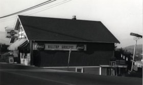
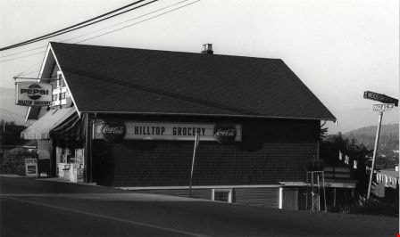
Hilltop Grocery
https://search.heritageburnaby.ca/link/archivedescription79116
- Repository
- City of Burnaby Archives
- Date
- October, 1976
- Collection/Fonds
- Burnaby Public Library Contemporary Visual Archive Project
- Description Level
- Item
- Physical Description
- 1 photograph : b&w ; 11 x 16 cm mounted on cardboard
- Scope and Content
- Photograph shows Hilltop Grocery located at 3690 Douglas Road, near the corner of Douglas Road and Woodsworth Street. It was built in 1916.
- Repository
- City of Burnaby Archives
- Date
- October, 1976
- Collection/Fonds
- Burnaby Public Library Contemporary Visual Archive Project
- Physical Description
- 1 photograph : b&w ; 11 x 16 cm mounted on cardboard
- Description Level
- Item
- Record No.
- 556-163
- Access Restriction
- No restrictions
- Reproduction Restriction
- Reproduce for fair dealing purposes only
- Accession Number
- 2013-13
- Scope and Content
- Photograph shows Hilltop Grocery located at 3690 Douglas Road, near the corner of Douglas Road and Woodsworth Street. It was built in 1916.
- Names
- Hilltop Grocery
- Media Type
- Photograph
- Photographer
- Salmon, Stu
- Notes
- Scope note taken directly from BPL photograph description.
- 1 b&w copy negative : 10 x 12.5 cm accompanying
- Geographic Access
- Douglas Road
- Street Address
- 3690 Douglas Road
- Historic Neighbourhood
- Burnaby Lake (Historic Neighbourhood)
- Planning Study Area
- Douglas-Gilpin Area
Images
![Ross Service Station, Douglas Road and Grandview Highway, 1922 (date of original), copied [1998] thumbnail](/media/hpo/_Data/_Archives_Images/_Unrestricted/316/358-001.jpg?width=280)
Ross Service Station, Douglas Road and Grandview Highway
https://search.heritageburnaby.ca/link/archivedescription37353
- Repository
- City of Burnaby Archives
- Date
- 1922 (date of original), copied [1998]
- Collection/Fonds
- Burnaby Historical Society fonds
- Description Level
- Item
- Physical Description
- 1 photograph : b&w ; 10 x 15 cm print
- Scope and Content
- Photograph of the Ross Service Station, located at Douglas road and Grandview Highway (now Canada Way). This station was built, owned and operated by Fred Ross.
- Repository
- City of Burnaby Archives
- Date
- 1922 (date of original), copied [1998]
- Collection/Fonds
- Burnaby Historical Society fonds
- Subseries
- Ross family subseries
- Physical Description
- 1 photograph : b&w ; 10 x 15 cm print
- Description Level
- Item
- Record No.
- 358-001
- Access Restriction
- No restrictions
- Reproduction Restriction
- No known restrictions
- Accession Number
- BHS1998-05
- Scope and Content
- Photograph of the Ross Service Station, located at Douglas road and Grandview Highway (now Canada Way). This station was built, owned and operated by Fred Ross.
- Names
- Ross Service Station
- Media Type
- Photograph
- Notes
- Title based on contents of photograph.
- The 1925 Burnaby Business Guide provides the address for this building as Douglas Road and Sprott Street.
- Geographic Access
- Douglas Road
- Sprott Street
- Canada Way
- Street Address
- 3355 Douglas Road
- Planning Study Area
- Douglas-Gilpin Area
Images
![Ross Service Station, Douglas Road and Grandview Highway, 1922 (date of original), copied [1998] thumbnail](/media/hpo/_Data/_Archives_Images/_Unrestricted/316/358-001.jpg)
![Ross Service Station, Douglas Road and Grandview Highway, 1930 (date of original), copied [1998] thumbnail](/media/hpo/_Data/_Archives_Images/_Unrestricted/316/358-002.jpg?width=280)
Ross Service Station, Douglas Road and Grandview Highway
https://search.heritageburnaby.ca/link/archivedescription37354
- Repository
- City of Burnaby Archives
- Date
- 1930 (date of original), copied [1998]
- Collection/Fonds
- Burnaby Historical Society fonds
- Description Level
- Item
- Physical Description
- 1 photograph : b&w ; 10 x 15 cm print
- Scope and Content
- Photograph of a man on a motorcycle, most likely Fred Ross's assistant, Terry Rowley, outside the Ross Service Station at Douglas road and Grandview Highway (now Canada Way). This station was built, owned and operated by Fred Ross.
- Repository
- City of Burnaby Archives
- Date
- 1930 (date of original), copied [1998]
- Collection/Fonds
- Burnaby Historical Society fonds
- Subseries
- Ross family subseries
- Physical Description
- 1 photograph : b&w ; 10 x 15 cm print
- Description Level
- Item
- Record No.
- 358-002
- Access Restriction
- No restrictions
- Reproduction Restriction
- No known restrictions
- Accession Number
- BHS1998-05
- Scope and Content
- Photograph of a man on a motorcycle, most likely Fred Ross's assistant, Terry Rowley, outside the Ross Service Station at Douglas road and Grandview Highway (now Canada Way). This station was built, owned and operated by Fred Ross.
- Names
- Ross Service Station
- Media Type
- Photograph
- Notes
- Title based on contents of photograph.
- The 1925 Burnaby Business Guide gives the address of this site as Douglas Road and Sprott Street.
- Geographic Access
- Douglas Road
- Sprott Street
- Canada Way
- Planning Study Area
- Douglas-Gilpin Area
Images
![Ross Service Station, Douglas Road and Grandview Highway, 1930 (date of original), copied [1998] thumbnail](/media/hpo/_Data/_Archives_Images/_Unrestricted/316/358-002.jpg)
![Sperling Avenue and Douglas Road, [between 1938 and 1940] (date of original), copied 1991 thumbnail](/media/hpo/_Data/_Archives_Images/_Unrestricted/370/370-534.jpg?width=280)
Sperling Avenue and Douglas Road
https://search.heritageburnaby.ca/link/archivedescription37947
- Repository
- City of Burnaby Archives
- Date
- [between 1938 and 1940] (date of original), copied 1991
- Collection/Fonds
- Burnaby Historical Society fonds
- Description Level
- Item
- Physical Description
- 1 photograph : b&w ; 2.8 x 3.7 cm print on contact sheet 20.6 x 26.1 cm
- Scope and Content
- Photograph of Sperling Avenue and Douglas Road. World Bros. Hardware can be seen on the north side of Douglas Road, with the General Store across the street.There are four people on horseback. The photograph was taken from Sperling Avenue.
- Repository
- City of Burnaby Archives
- Date
- [between 1938 and 1940] (date of original), copied 1991
- Collection/Fonds
- Burnaby Historical Society fonds
- Subseries
- Burnaby Image Bank subseries
- Physical Description
- 1 photograph : b&w ; 2.8 x 3.7 cm print on contact sheet 20.6 x 26.1 cm
- Description Level
- Item
- Record No.
- 370-534
- Access Restriction
- No restrictions
- Reproduction Restriction
- No known restrictions
- Accession Number
- BHS1999-03
- Scope and Content
- Photograph of Sperling Avenue and Douglas Road. World Bros. Hardware can be seen on the north side of Douglas Road, with the General Store across the street.There are four people on horseback. The photograph was taken from Sperling Avenue.
- Names
- World Brothers Hardware
- Media Type
- Photograph
- Notes
- Title based on contents of photograph
- 1 b&w copy negative accompanying
- Geographic Access
- Sperling Avenue
- Douglas Road
- Historic Neighbourhood
- Burnaby Lake (Historic Neighbourhood)
- Planning Study Area
- Morley-Buckingham Area
Images
![Sperling Avenue and Douglas Road, [between 1938 and 1940] (date of original), copied 1991 thumbnail](/media/hpo/_Data/_Archives_Images/_Unrestricted/370/370-534.jpg)
![Tram Station at Cumberland Road, [194-] thumbnail](/media/hpo/_Data/_BVM_Images/1977/197900390001.jpg?width=280)
Tram Station at Cumberland Road
https://search.heritageburnaby.ca/link/museumdescription441
- Repository
- Burnaby Village Museum
- Date
- [194-]
- Collection/Fonds
- Burnaby Village Museum Photograph collection
- Description Level
- Item
- Physical Description
- 1 photograph : b&w ; 9.0 x 6.3 cm
- Scope and Content
- Photograph of a woman sitting on the rail of a wooden walkway into a building. On the side of the building is painted a sign: "Cumberland / Road." Also visible on the wood plank wall is graffiti of a name: "John Mealings." An annotation on the back of the photo reads: "Eileen Bobergs' friend mid …
- Repository
- Burnaby Village Museum
- Collection/Fonds
- Burnaby Village Museum Photograph collection
- Description Level
- Item
- Physical Description
- 1 photograph : b&w ; 9.0 x 6.3 cm
- Scope and Content
- Photograph of a woman sitting on the rail of a wooden walkway into a building. On the side of the building is painted a sign: "Cumberland / Road." Also visible on the wood plank wall is graffiti of a name: "John Mealings." An annotation on the back of the photo reads: "Eileen Bobergs' friend mid 1940's / Burnaby Lake Tram Station." Stamped on the back of the photo: "205."
- Geographic Access
- Cumberland Street
- Burnaby Lake Interurban line
- Accession Code
- HV979.39.1
- Access Restriction
- No restrictions
- Reproduction Restriction
- May be restricted by third party rights
- Date
- [194-]
- Media Type
- Photograph
- Historic Neighbourhood
- East Burnaby (Historic Neighbourhood)
- Planning Study Area
- Cariboo-Armstrong Area
- Scan Resolution
- 600
- Scan Date
- 2023-09-12
- Notes
- Title based on contents of photograph
Images
![Tram Station at Cumberland Road, [194-] thumbnail](/media/hpo/_Data/_BVM_Images/1977/197900390001.jpg)