Narrow Results By
Subject
- Accidents - Automobile Accidents 1
- Advertising Medium 22
- Advertising Medium - Poster 1
- Advertising Medium - Signs and Signboards 255
- Aerial Photographs 1
- Agricultural Tools and Equipment 1
- Agriculture 2
- Agriculture - Crops 8
- Agriculture - Farms 4
- Agriculture - Fruit and Berries 5
- Agriculture - Poultry 1
- Animals - Birds 1
Person / Organization
- A & Aero Trading Salvage 1
- Adlem, Joan 1
- Admiral Hotel 4
- A & H Plastering and Stucco 1
- Aldersley, Ernie 1
- Alfred Horie Construction Company Limited 1
- Alpha Secondary School 1
- A. MacKenzie and Company Jubilee Store 5
- Anderson and Phillips Builders 1
- Anderson, Kathleen 1
- Anthony, Bill 1
- Archibald, Charles 1
![Burnaby Public Library Summer Reading Club wrap-up party, [2002] thumbnail](/media/hpo/_Data/_Archives_Images/_Unrestricted/535/535-2773-1.jpg?width=280)
Burnaby Public Library Summer Reading Club wrap-up party
https://search.heritageburnaby.ca/link/archivedescription97398
- Repository
- City of Burnaby Archives
- Date
- [2002]
- Collection/Fonds
- Burnaby NewsLeader photograph collection
- Description Level
- File
- Physical Description
- 2 photographs (tiff) : col.
- Scope and Content
- File contains photographs of the Burnaby Public Library's wrap-up party for its Summer Reading Club. Photographs depict Chantel Jones and Walter Pineda of the Holiday Inn at Metrotown making pancakes for the party's breakfast, and Summer Reading Club participant Graeme Zacharias playing with giant …
- Repository
- City of Burnaby Archives
- Date
- [2002]
- Collection/Fonds
- Burnaby NewsLeader photograph collection
- Physical Description
- 2 photographs (tiff) : col.
- Description Level
- File
- Record No.
- 535-2773
- Access Restriction
- No restrictions
- Reproduction Restriction
- No restrictions
- Accession Number
- 2018-12
- Scope and Content
- File contains photographs of the Burnaby Public Library's wrap-up party for its Summer Reading Club. Photographs depict Chantel Jones and Walter Pineda of the Holiday Inn at Metrotown making pancakes for the party's breakfast, and Summer Reading Club participant Graeme Zacharias playing with giant bubbles during the party.
- Subjects
- Events
- Events - Parties
- Persons - Children
- Names
- Burnaby Public Library
- Media Type
- Photograph
- Photographer
- Bartel, Mario
- Notes
- Title based on caption
- Collected by editorial for use in a September 2002 issue of the Burnaby NewsLeader
- Caption from metadata for 535-2773-1: "Chantel Jones and Walter Pineda, of the Holiday Inn at Metrotown, team up to flip pancakes at the Burnaby Library's wrap-up party for its Summer Reading Club. More than 6,100 kids signed up for the club, which required them to read at least 15 minutes a day for 50 days of the summer."
- Caption from metadata for 535-2773-2: "His summer reading completed, Graeme Zacharias, 8, makes giant soap bubbles at the wrap-up party and pancake breakfast for the Burnaby Library's Summer Reading Club. More than 6,100 kids signed up for the program, which required participants to read at least 15 minutes a day for 50 days through the summer."
- Geographic Access
- Kingsway
- Historic Neighbourhood
- Central Park (Historic Neighbourhood)
- Planning Study Area
- Maywood Area
Images
![Burnaby Public Library Summer Reading Club wrap-up party, [2002] thumbnail](/media/hpo/_Data/_Archives_Images/_Unrestricted/535/535-2773-1.jpg)
card
https://search.heritageburnaby.ca/link/museumartifact39322
- Repository
- Burnaby Village Museum
- Accession Code
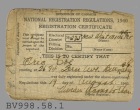
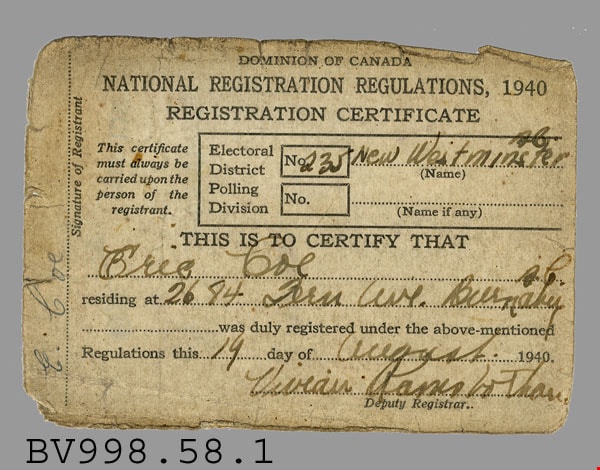
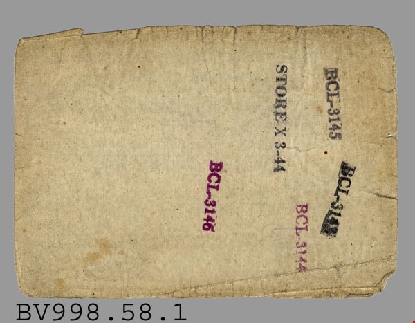
- BV998.58.1
- Description
- National Registration Regulations - Card -- [1940]. Dominion of Canada National Registration Card for Eric Coe of 2684 Fern Avenue, Burnaby. Eric Coe was Part of the Electoral District Number 235 New Westminster, B.C. The registration card was signed on August 19th, 1940 and was signed by Deputy Registrar Vivean Ramsbothan (?). On the back of the card are several ink stamps "BCL-3143", "BCL-3144", "BCL-3145", "BCL 3146" and "STORE X 3-44". The card measures 10cm x 7cm.
- Colour
- White
- Names
- Coe, Eric
Images
form
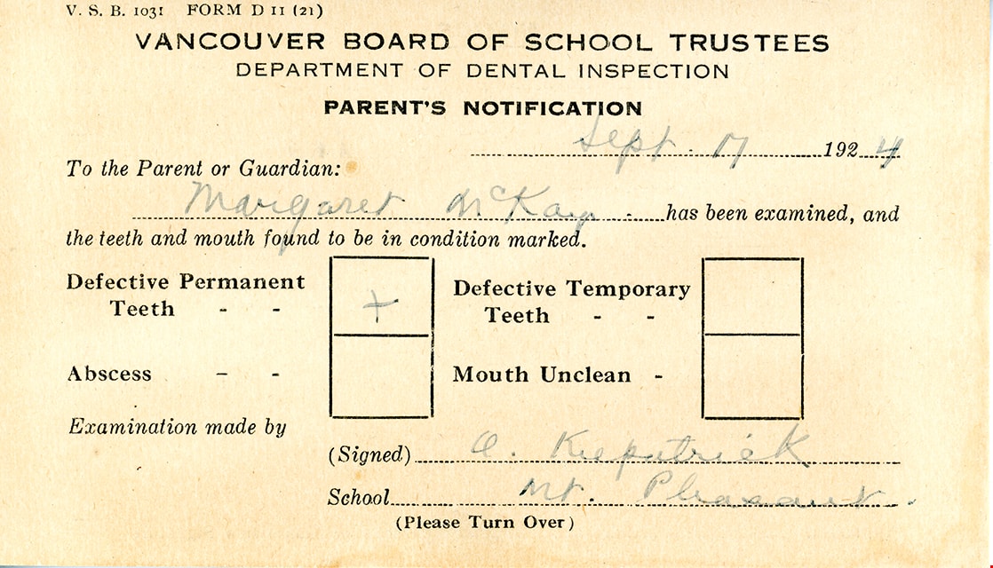
https://search.heritageburnaby.ca/link/museumartifact1970
- Repository
- Burnaby Village Museum
- Accession Code
- HV971.120.42
- Description
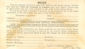
- Department of Dental Inspection - Form -- [1924]. Vancouver Board of School Trustees Department of Dental Inspection; Parent's notification; Sept.17 1924; Margaret McKay; finding is 'Defective Permanent Teeth'; signed A. Kilpatrick, Mr. Pliasaut?; reverse of card has "NOTICE", advising the parents to take their child to the dentist; card must be signed by dentist after treatment and card returned to school nurse; application for dental treatment at the school at bottom of card; envelope is plain, "Mrs. M McKay" handwritten on back
- Names
- Bingham, Alfred "Alf"
Images


Property master designs for "X2: X-Men United"
https://search.heritageburnaby.ca/link/museumdescription19154
- Repository
- Burnaby Village Museum
- Date
- [2002]
- Collection/Fonds
- Hipman "Jimmy" Chow and Donna Polos fonds
- Description Level
- File
- Physical Description
- 1 portfolio : 15 photographs : col. prints + 12 col. laser prints
- Scope and Content
- File consists of a portfolio of prop concept design plans, prototypes and resource photographs for the Marvel film "X2: X-Men United". Concept designs were created by different designers and portfolio of collection was created by property master, Jimmy Chow. The portfolio was used as a communicatio…
- Repository
- Burnaby Village Museum
- Collection/Fonds
- Hipman "Jimmy" Chow and Donna Polos fonds
- Description Level
- File
- Physical Description
- 1 portfolio : 15 photographs : col. prints + 12 col. laser prints
- Scope and Content
- File consists of a portfolio of prop concept design plans, prototypes and resource photographs for the Marvel film "X2: X-Men United". Concept designs were created by different designers and portfolio of collection was created by property master, Jimmy Chow. The portfolio was used as a communication tool for sharing prototypes and plans with Jimmy's team who worked with him on the film. The film was directed by Bryan Singer and was released in 2003. Some of the concept designs within the portfolio were created by assistant art director, Brenton Harron, signed "Harron" and illustrator Dean Sherriff , signed "Sheriff".
- Accession Code
- BV022.21.107
- Access Restriction
- Restricted access
- Reproduction Restriction
- May be restricted by third party rights
- Date
- [2002]
- Media Type
- Photograph
- Graphic Material
- Scan Resolution
- 600
- Scan Date
- 2023-03-10
- Notes
- Title based on contents of file
- Title on spine of cover of portfolio reads: "X2 / PROPS"
- Chinese seal in red ink on spine of cover of portfolio identifying Jimmy Chow as the owner or creator
Images

![Subdivision plans in New Westminster District Group 1 – Burnaby
, [1893-1910] thumbnail](/media/hpo/_Data/_BVM_Cartographic_Material/1977/1977_0093_0016a_001.jpg?width=280)
Subdivision plans in New Westminster District Group 1 – Burnaby
https://search.heritageburnaby.ca/link/museumdescription6985
- Repository
- Burnaby Village Museum
- Date
- [1893-1910]
- Collection/Fonds
- Burnaby Village Museum Map collection
- Description Level
- File
- Physical Description
- 4 plans : blueprint ink on paper mounted on 2 sides of cardboard 76 x 102 cm
- Scope and Content
- Item consists of a large board of two New Westminster District Gp 1 - subdivision plans mounted on one side and two New Westminster District Gp 1 - subdivision plans mounted on the other side. Side A: 1. Blueprint "Plan / of Subdivision / of / Lot 6 / Group One / New Westminster District / Scale…
- Repository
- Burnaby Village Museum
- Collection/Fonds
- Burnaby Village Museum Map collection
- Description Level
- File
- Physical Description
- 4 plans : blueprint ink on paper mounted on 2 sides of cardboard 76 x 102 cm
- Material Details
- Scales [between 1:1584 and 1:3960]
- Index number on edge of board reads: "16"
- Scope and Content
- Item consists of a large board of two New Westminster District Gp 1 - subdivision plans mounted on one side and two New Westminster District Gp 1 - subdivision plans mounted on the other side. Side A: 1. Blueprint "Plan / of Subdivision / of / Lot 6 / Group One / New Westminster District / Scale 5 chs = 1 in. / Map No 748" (Geographic location: Burnaby) 2. Blueprint "Plan / of Subdivision / of a Portion / of / Lot 29 / Group One / New Westminster Dist. / Scale 2 chs = 1 in. / Map No." Name identified in Block H is "Reichenbach" (Geographic location: Burnaby) Side B: 1. Blueprint "Plan / of Subdivision / of North 1/2 of Lot 80 / Group One / New Westminster District / Scale 3 chs = 1 in. / Map No 719" Plan is signed by: "Garden, Hermon & Burwell P.L.S. / Vancouver Jan. 23rd, 1893" (Geographic location: Burnaby) 2. Blueprint "Plan / of Subdivision / of Lot 79, Gr.1 / New Westminster Dist. / Scale 4 chas = 1 in. / Map No 536" Plan is signed by "Garden Hermon & Burwell / Provincial Land Surveyors". (Geographic location: Burnaby)
- Creator
- Garden, Hermon and Burwell
- Accession Code
- HV977.93.16
- Access Restriction
- No restrictions
- Reproduction Restriction
- No known restrictions
- Date
- [1893-1910]
- Media Type
- Cartographic Material
- Historic Neighbourhood
- Edmonds (Historic Neighbourhood)
- Burnaby Lake (Historic Neighbourhood)
- Planning Study Area
- Douglas-Gilpin Area
- Edmonds Area
- Cameron Area
- Scan Resolution
- 300
- Scale
- 72
- Notes
- Title based on contents of file
- Scale is measured in chains. (One chain equals 792 inches)
- The term "Lot" can also refer to a "District Lot”
Images
![Subdivision plans in New Westminster District Group 1 – Burnaby
, [1893-1910] thumbnail](/media/hpo/_Data/_BVM_Cartographic_Material/1977/1977_0093_0016a_001.jpg)

![Survey and Subdivision plans in New Westminster District Group 1 – Burnaby
, [1908] thumbnail](/media/hpo/_Data/_BVM_Cartographic_Material/1977/1977_0093_0004a_001.jpg?width=280)
Survey and Subdivision plans in New Westminster District Group 1 – Burnaby
https://search.heritageburnaby.ca/link/museumdescription6973
- Repository
- Burnaby Village Museum
- Date
- [1908]
- Collection/Fonds
- Burnaby Village Museum Map collection
- Description Level
- File
- Physical Description
- 10 plans : blueprint ink on paper mounted on 2 sides of cardboard ; 76 cm x 102 cm
- Scope and Content
- Item consists of a large board of four New Westminster District Gp 1 - subdivision plans mounted on one side and six New Westminster District Gp 1 - subdivision plans mounted on the other side. Side A: 1. Blueprint "Plan / of - ReSubdivision / of / Lots 1-18 inclusive / Blocks 20 and 21 / in Sub…
- Repository
- Burnaby Village Museum
- Collection/Fonds
- Burnaby Village Museum Map collection
- Description Level
- File
- Physical Description
- 10 plans : blueprint ink on paper mounted on 2 sides of cardboard ; 76 cm x 102 cm
- Material Details
- Scales [between 1:792 and 1:4752]
- Index number on edge of board reads: "4"
- Scope and Content
- Item consists of a large board of four New Westminster District Gp 1 - subdivision plans mounted on one side and six New Westminster District Gp 1 - subdivision plans mounted on the other side. Side A: 1. Blueprint "Plan / of - ReSubdivision / of / Lots 1-18 inclusive / Blocks 20 and 21 / in Subdivision / of / Lot 53 -Gr.1 / New Westminster District" / "Subdivision Lot Numbers - Shown in Red". Plan is bordered by First Street / Jorgenson's Line / Fourth Avenue and Second Street with Fifith Avenue running through the centre. There is an index in the upper right corner of the plan. Planned is signed by "Peter Byrne" and "William R. Phillips" and dated July 28, 1908. (Geographic location: Burnaby) 2. Blueprint "Plan / of Subdivision / of / Lot 159 / and a Portion of Lot 158 / Group One / New Westminster District". Plan is bordered by Lots 96 and 97; South Wilson Street; North Arm Road and Lot 160 / Power House Road (Lot 155 A). B.C.E.R. Gilley Station is identified in the upper right corner of the plan. (Geographic location: Burnaby) 3. Blueprint plan identified as "Subdvs 10, L 88 and Lot 25, G. 1" Plan identifies Cumberland Street running from top to the bottom and a Ravine running alongside with the Jensen house, stable and barn. (Geographic location: Burnaby) 4. Blueprint Plan of "Lot 153. G. 1 /New Westminster District". Plan identifies the "New Westminster & Vancouver Tramway" and the "New Westminster and Vancouver Road" running through the plan of Lot 53. (Geographic location: Burnaby) Side B: 1. Blueprint plan of "Profile on Proposed North Rd. Diversion". 2. Blueprint plan (no title) showing wood lots north of Burnaby Lake and Brunette River and west of North Road. Various lots are identified as "Heavily Timbered" (Lot 57); "Splendid Fir and Cedar / Heavy Fir etc. / Fine Cedar" (Lots 143, 148); "Rough Light Timber," (Lot 56); "Some Fir and Cedar" (Lot 40). (Geographic location: Burnaby) 3. Blueprint "Plan / of Subdivision / of a Portion / of Lot 87, Gr.1 / New Westminster District". Plan is bordered by Burnaby Lake at the top and Hastings Road / Lot 86 at the bottom and Lot 90 to the east. "Albert J. Hill B.C.LotS." Annotation in ink reads: " J.A. Brownlee, B.C.L.S. / Subdivision / Map 1494 / Bd. 248". Plan is signed by "Peter Byrne, Reeve" (Geographic location: Burnaby) 4. Blueprint plan of Subdivisions along either side of Douglas Road including Lots 117; 119; 74; 80; 79 and 77. (Geographic location: Burnaby) 5. Blueprint "Plan / of / Subdivision of / Lot 27 / in Subdivision / of / Lot 30 / Group One / New Westminster District" Plan is bordered by Lot 26, Lot 28 and Hastings Rd. Lot 27 runs north of Edmonds Street. , "Albert J. Hill, B.C.LotS." (Geographic location: Burnaby) 6. Blueprint plan identified as a "Cultivated Orchard" including the names "W. Grace" and "G. Mead" located north of the North Arm Fraser River and west of "Twentieth Street_ City Boundary". Handwritten annotation in coloured pencil reads: "Portion of Lot 172" (Geographic location: Burnaby)
- Subjects
- Geographic Features - Forests
- Geographic Access
- Cumberland Street
- North Road
- Hastings Street
- Douglas Road
- Accession Code
- HV977.93.4
- Access Restriction
- No restrictions
- Reproduction Restriction
- No known restrictions
- Date
- [1908]
- Media Type
- Cartographic Material
- Historic Neighbourhood
- Burnaby Lake (Historic Neighbourhood)
- Fraser Arm (Historic Neighbourhood)
- Planning Study Area
- Douglas-Gilpin Area
- Burnaby Lake Area
- Scan Resolution
- 300
- Scale
- 72
- Notes
- Title based on contents of file
- Scale is measured in chains. (One chain equals 792 inches)
- The term "Lot" can also refer to a "District Lot”-
Images
![Survey and Subdivision plans in New Westminster District Group 1 – Burnaby
, [1908] thumbnail](/media/hpo/_Data/_BVM_Cartographic_Material/1977/1977_0093_0004a_001.jpg)

![Survey and Subdivision plans in New Westminster District Group 1 – Burnaby
, [1906-1908] thumbnail](/media/hpo/_Data/_BVM_Cartographic_Material/1977/1977_0093_0008a_001.jpg?width=280)
Survey and Subdivision plans in New Westminster District Group 1 – Burnaby
https://search.heritageburnaby.ca/link/museumdescription6977
- Repository
- Burnaby Village Museum
- Date
- [1906-1908]
- Collection/Fonds
- Burnaby Village Museum Map collection
- Description Level
- File
- Physical Description
- 5 plans : blueprint ink on paper + 1 plan : pencil on paper mounted on 2 sides of cardboard 76 x 102 cm
- Scope and Content
- Item consists of a large board of three New Westminster District Gp 1 - plans mounted on one side and two New Westminster District Gp 1 - subdivision plans mounted on the other side. Side A: 1. Blueprint "Plan / of / Lot 155A Group 1 / Showing / Water Courses and General Topography, etc. / Scale…
- Repository
- Burnaby Village Museum
- Collection/Fonds
- Burnaby Village Museum Map collection
- Description Level
- File
- Physical Description
- 5 plans : blueprint ink on paper + 1 plan : pencil on paper mounted on 2 sides of cardboard 76 x 102 cm
- Material Details
- Scales [between 1:396 and 1:3168]
- Index number on edge of board reads: "8"
- Scope and Content
- Item consists of a large board of three New Westminster District Gp 1 - plans mounted on one side and two New Westminster District Gp 1 - subdivision plans mounted on the other side. Side A: 1. Blueprint "Plan / of / Lot 155A Group 1 / Showing / Water Courses and General Topography, etc. / Scale 200' = 1 / 171, G. 1 " Plans identifies Woodland, North Arm Road, Chinese Gardens, Woollard's Ditch and Woollard's Brook. (Geographic location: Burnaby) 2. Blueprint plan (no title) with handwritten annotation at the top "Lot 13. G.1" Streets on the plan are identified as Armstrong Street, Cariboo Road and Lillooet Street with the subdivided area lying above District Lot 1. (Geographic location: Burnaby) 3. Blueprint plan (no title) of subdivision of a portion of Lot 85. Subdivision is bordered by Deer Lake, Pole Line Road, Lot 85, Lot 86, Lot 92, Lot 93 and Lot 84. Plan is signed by "H.Neville Smith / C.E., B.C.L.S." "New Westminster / November 1906". (Geographic location: Burnaby) 4. Plan drawn in pencil "Lot 85, Gr.1 / Scale 2 in = 1 ch / Albert E. Hill / 6/5/08". Plan identifies Pole (Line Rd.) and Hastings Road. (Geographic location: Burnaby) Side B: 1. Blueprint "Subdivision of / Certain portion / of / Lot 28, Gr.1 /Sc. 100 ' = 1"" Plan identifies: Westminster & Vancouver Tramway Co.s Property, Block A, Douglas Street, May Street, Mary Street, Fourth Avenue, Fifth Avenue, Sixth Avenue, Seventh Avenue, Eighth Avenue, Ninth Avenue, Tenth Avenue, Eleventh Avenue and Westminster & Vancouver Tramway. (Geographic location: Burnaby) 2. Blueprint "Plan, Shewing Subdivision / DL 171 & Part of DL 160 / N.W.D.". Top of Plan includes an identifier: "REC. Map 992 / BD. 174". Plan is signed by G.E. Jorgenson B.C.L.S. Vancouver, B.C. May 14, 1907 and by Peter Byrne, Reeve. (Geographic location: Burnaby)
- Creator
- Smith, H. Neville
- Accession Code
- HV977.93.8
- Access Restriction
- No restrictions
- Reproduction Restriction
- No known restrictions
- Date
- [1906-1908]
- Media Type
- Cartographic Material
- Scan Resolution
- 300
- Scale
- 72
- Notes
- Title based on contents of file
- Scale is measured in chains and feet. (One chain equals 792 inches)
- Photograph only shows 1. Plan, L. 155A Gr.1
- The term "Lot" can also refer to a "District Lot"
Images
![Survey and Subdivision plans in New Westminster District Group 1 – Burnaby
, [1906-1908] thumbnail](/media/hpo/_Data/_BVM_Cartographic_Material/1977/1977_0093_0008a_001.jpg)

![Survey and Subdivision plans in New Westminster District Group 1 – Burnaby, Port Moody, [1862-1908] thumbnail](/media/hpo/_Data/_BVM_Cartographic_Material/1977/1977_0093_0026a_001.jpg?width=280)
Survey and Subdivision plans in New Westminster District Group 1 – Burnaby, Port Moody
https://search.heritageburnaby.ca/link/museumdescription6995
- Repository
- Burnaby Village Museum
- Date
- [1862-1908]
- Collection/Fonds
- Burnaby Village Museum Map collection
- Description Level
- File
- Physical Description
- 9 plans : 6 plans : black ink on paper ; 57 x 36.5 cm or smaller + 1 plan : black ink and grahite on paper ; 46.5 x 49 cm + 1 plan : blueprint on paper ; 15.5 x 19.5 cm + cm + 1 plan : graphite on paper ; 25 x 17 cm ; mounted on both sides of board 76 x 102 cm
- Scope and Content
- Item consists of a large board of four New Westminster District subdivision plans mounted on one side and five New Westminster District subdivision plans mounted on the other side. Side A: 1. "Plan / of Subdivision / of a Portion / of / Lot 87 / Group One / New Westminster District / Scale 4 chs…
- Repository
- Burnaby Village Museum
- Collection/Fonds
- Burnaby Village Museum Map collection
- Description Level
- File
- Physical Description
- 9 plans : 6 plans : black ink on paper ; 57 x 36.5 cm or smaller + 1 plan : black ink and grahite on paper ; 46.5 x 49 cm + 1 plan : blueprint on paper ; 15.5 x 19.5 cm + cm + 1 plan : graphite on paper ; 25 x 17 cm ; mounted on both sides of board 76 x 102 cm
- Material Details
- Scales [between 1:792 and 1:3600]
- Index number on edge of board reads: "26"
- Scope and Content
- Item consists of a large board of four New Westminster District subdivision plans mounted on one side and five New Westminster District subdivision plans mounted on the other side. Side A: 1. "Plan / of Subdivision / of a Portion / of / Lot 87 / Group One / New Westminster District / Scale 4 chs = 1 in". Plan is stamped: "Albert J. Hill, Civil Engineer / and / Provincial Land Surveyor, / New Westminster, / B.C." and intialed by: "RB" [sic] (in blue pencil crayon). Names two of the subdivisons of District Lot 87 are identified as, "L.E. Sprott" and "John Ledger". (Geographic location: Burnaby) 2. "Plan of Subdivision / of / Portions of / Lot 136, 131 and Lots 44 and 78 Gr.1 / New Westminster District / Scale 300 ft = 1 inch". Annotation above title reads: "No. 901 / Deposited in Land Registry Office / New Westminster / Aug. 19th 1905 / Charles S. Keith D. Reg." Annotations and signatures at bottom of plan read: "I, William Nelson Draper, / W.H.R. Collister / Charles E. Perkins / E.B. Morgan / make / Surveys / correct / representation / upon / the / Land Registry Act / (sgd) W.N. Draper, P.L.S.". Plan includes a handwritten title: "Lots 136, 131, 44 & 78" and is initialed: "RB" [sic] (in blue pencil crayon) (Geographic location: Burnaby) 3. "Survey / of / a Portion / of / Lot 95, Gr.1 / Scale 1 ch = 1in." Plan is stamped: "Albert J. Hill, Civil Engineer / and / Provincial Land Surveyor, / New Westminster, / B.C." and is initialed : "RB" [sic] (in blue pencil crayon) (Geographic location: Burnaby) 4. Blueprint plan of "Lot 396. Group One." with Scale : 3 chs = 1 in. A two acre portion of District Lot 396 is filled in with red ink." Plan is signed by "Albert J. Hill / B.C.L.S." (Geographic location: Port Moody) Side B: 1. Plan titled "District Lot 92 / Burnaby / Municipality / for sale by / Mahon / McFarland & / Mahon Ltd. / Vancouver, B.C. / Scale : 4 chains to one inch". District Lot 92 is subdivided into 161 lots and identifies roads: Norwich Road, Pole Line Road, Oakland Road, Stanley Road, Burford Road, Dalhousie Road, Brantford Road, Colborne Road, Roberts Road, Vancouver & Westminster Road, B.C. Electric Railway, Gilley Stn. and Burnaby (Power House). The bottom of the plan reads: "G.S. Dawson, P.LS. Vancouver, B.C." (Geographic location: Burnaby) 2. "Plan / of Subdivision / of a Portion / of / Lot 29 / Group 1 / New Westminster District / Scale 2 chs = 1 in". Plan is stamped: "Albert J. Hill, Civil Engineer / and / Provincial Land Surveyor, / New Westminster, / B.C." and is initialed by: "RB" [sic] (in blue pencil crayon) (Geographic location: Burnaby) 3. Small handrawn plan (no title) identifying "Lot 84 / Hydes, Claim" at the centre surrounded by lots and features identified as: "Lot 85", "Lot 93", "Lot 94", "Lot 32", "Lot 82", "Lot 83", "Lot 79", "swamp" and a "Small Lake" (Burnaby Lake). Identifying marks in the right corner of the plan read: "Page 13 / Surveyed by G. Turner / May 62". Plan also includes surveyor's bearing measurements and trails to "Small Lake" (Burnaby Lake). (Geographic location: Burnaby) 4. Untitled plan showing District Lots west of North Road and north of Burnaby Lake including: Lots 2, 4, 6, 8, 15, 10, 56, 148, 57, 58, 40. and Lots 3, 5, 7 east of North Road (Coquitlam). Lots in Burnaby are identifed for timber including: "Heavily Timbered" (Lot 57), " "Some Fir and Cedar" (Lot 40), "Splendid Fir and Cedar" (Lot 143), "Heavy Fir etc" (Lots 143 and 148), " "Fine Cedar" (Lot 15), "Rough Light Timber" (Lot 56). Other features identified at the lower portion of the plan include "Burnaby Lake" and "Brunette River". (Geographic location: Burnaby) 5. Untitled plan drawn in graphite showing sections of District Lot 85 south of Burnaby Lake and north of Hazsard Road. Plan is signed: "Albert J. Hill / B.C.L.S." and dated "12/26/08". Plan is initialed by: "RB" [sic] (in blue pencil crayon) (Geographic location: Burnaby)
- Publisher
- Mahon, McFarland & Mahon Ltd
- Accession Code
- HV977.93.26
- Access Restriction
- No restrictions
- Reproduction Restriction
- No known restrictions
- Date
- [1862-1908]
- Media Type
- Cartographic Material
- Historic Neighbourhood
- Burnaby Lake (Historic Neighbourhood)
- Burquitlam (Historic Neighbourhood)
- Planning Study Area
- Burnaby Lake Area
- Scan Resolution
- 300
- Scale
- 72
- Notes
- Title based on contents of file
- Scale is measured in chains and feet. (One chain equals 792 inches)
- The term "Lot" can also refer to a "District Lot”
Images
![Survey and Subdivision plans in New Westminster District Group 1 – Burnaby, Port Moody, [1862-1908] thumbnail](/media/hpo/_Data/_BVM_Cartographic_Material/1977/1977_0093_0026a_001.jpg)


![Survey and Subdivision plans in New Westminster District Group 2 - Surrey and Map of Surrey Municipality, [190-] thumbnail](/media/hpo/_Data/_BVM_Cartographic_Material/1977/1977_0093_0094_003.jpg?width=280)
Survey and Subdivision plans in New Westminster District Group 2 - Surrey and Map of Surrey Municipality
https://search.heritageburnaby.ca/link/museumdescription7063
- Repository
- Burnaby Village Museum
- Date
- [190-]
- Collection/Fonds
- Burnaby Village Museum Map collection
- Description Level
- File
- Physical Description
- 5 plans : blueprints on paper ; various sizes mounted on 2 sides of cardboard 76 x 102 cm
- Scope and Content
- File consists of a large board with two plans in New Westminster District (Group 2) mounted on one side and three plans in New Westminster District (Group 2) mounted on the other side. Side A: 1. Plan : blueprint on paper ; 75.5 x 64.5 cm. Title reads: "South Westminster / Plan/ of Subdivision of…
- Repository
- Burnaby Village Museum
- Collection/Fonds
- Burnaby Village Museum Map collection
- Description Level
- File
- Physical Description
- 5 plans : blueprints on paper ; various sizes mounted on 2 sides of cardboard 76 x 102 cm
- Material Details
- Scales vary (One chain equals 792 inches)
- Indexed number on tape on edge of board reads 94"
- Scope and Content
- File consists of a large board with two plans in New Westminster District (Group 2) mounted on one side and three plans in New Westminster District (Group 2) mounted on the other side. Side A: 1. Plan : blueprint on paper ; 75.5 x 64.5 cm. Title reads: "South Westminster / Plan/ of Subdivision of / Lot 440, G2, E1/2Sec36, NE1/4Sec25, N1/2ofSE1/4Sec25, T4.NW1/4S31,T2.". Subdivision plan covers subdivided property in Lot 440 and Section 36, Section 25 in New Westminster, Group 2, Township 4 (Delta) and Section 31 in Township 2 (Surrey). Includes inset map noting property in "South Westminster". Map is bordered by Burrard Inlet to the north and Mud Bay to the south. (Geographic locations: North Delta and Surrey) 2. Plan : blueprint on paper ; 22.5 x 59.5 cm. Title reads: "Plan / Shewing part of / Section 10 Block 5 North R.I.W. / New Westminster District / Lying North of B.C.S.Railway". Scale: 2 chains = 1 inch. Signed by A.S. Colton, District Land Surveyor. March 1, 1900. Plan covers property in Section 10, Block 5 North in New Westminster District, Group 2, along the south shore of the Fraser River with the Great Northern Railway running through. (Geographic location: Surrey) Side B: 1. Map : blueprint on paper ; 69 x 53 cm. Title reads: "Map / of / Surrey Municipality". Scale: 5 chains = 1 inch. Creator and surveyor of map is identified as "Albert J. Hill, M.A., Civil Engineer / And / Provincial Land Surveyor, / New Westminster, / B.C.". Map identifies property divisions including lots with names of property owners, Sections, Townships, Wards, waterways, major roads, railways and the Semiahmoo Indian Reserve on the shore of "Semiahmoo Bay" and an indian reserve (I.R.) located in Lot 1 along the south shore of the Fraser River. 2. Plan : blueprint on paper ; 21 x 40.5 cm. Title reads: "Plan / of / Sudivision of / Section 32, / Block 5 North Range 1 West, / District of New Westminster, B.C.". Scale: 4 chains = 1 inch. Sudivision plan is signed by Albert J. Hill, B.C. Land Surveyor. Plan covers Section 32, subdivided into 28 parcels. Section 32 is bordered by Section 29 (north), Section 33, Johnston Road (east), Section 34, Township 2, Town Line Road (south) and Section 31 (west). (Geographic location: Surrey) 3. Plan : blueprint on paper ; 49.5 x 37 cm. Title reads: "Traverse of the Waterline / in front of / Lots 3 and 4 Group 2 / N.W.D. / with G.N. Railway Rt of Way". Scale: 100 feet = 1 inch. Annotation on board below plan reads: "also see Boards 87 & 93 & 110". Location south of the Fraser River with old wharf identified and Great Northern Railway running east to west along the river. (Geographic location: Surrey)
- Names
- Great Northern Railway
- Accession Code
- HV977.93.94
- Access Restriction
- No restrictions
- Reproduction Restriction
- No known restrictions
- Date
- [190-]
- Media Type
- Cartographic Material
- Scan Resolution
- 600
- Scan Date
- 2023-06-26
- Notes
- Title based on contents of file
Zoomable Images
![Survey and Subdivision plans in New Westminster District Group 2 - Surrey and Map of Surrey Municipality, [190-] thumbnail](/media/hpo/_Data/_BVM_Cartographic_Material/1977/1977_0093_0094_003_seadragon/1977_0093_0094_003.jpg?w=280)
Survey and Subdivision plans in New Westminster District Group 2 - Surrey and Map of Surrey Municipality, [190-]
Zoom into Image
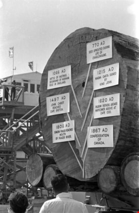
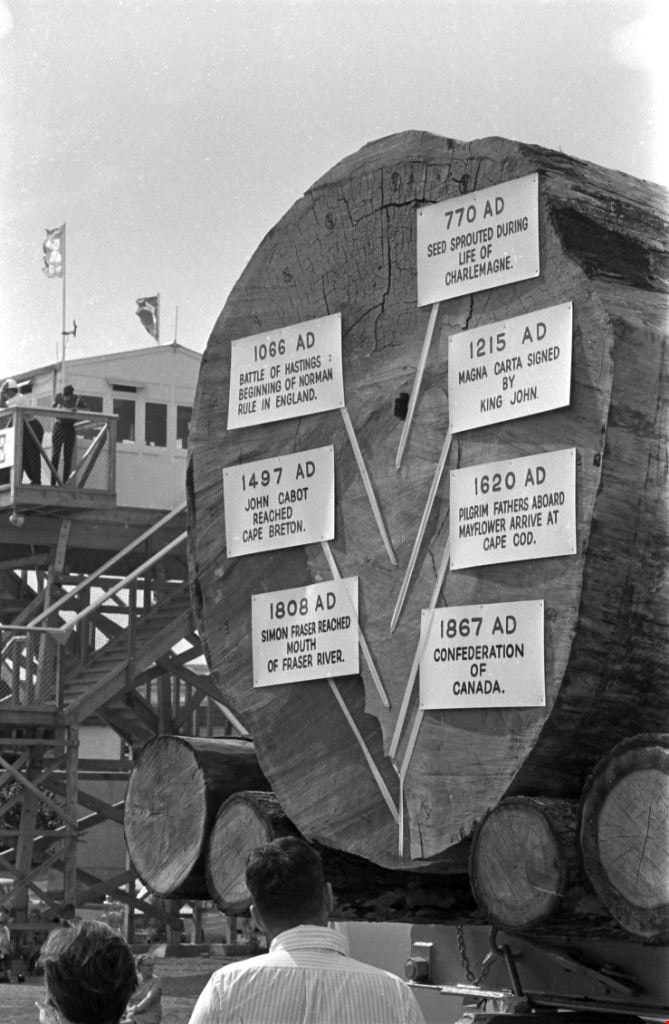
1200 Year Old Log
https://search.heritageburnaby.ca/link/archivedescription51441
- Repository
- City of Burnaby Archives
- Date
- 1967
- Collection/Fonds
- Harold H. Johnston fonds
- Description Level
- Item
- Physical Description
- 1 photograph (jpeg) : b&w
- Scope and Content
- Photograph of a log that has been put on display at the Pacific National Exhibition in Vancouver, BC. The log was dated as being 1200-years old and markers were placed on various rings to date the tree and make mention of historical events that took place in those years. The signs read: 770 AD See…
- Repository
- City of Burnaby Archives
- Date
- 1967
- Collection/Fonds
- Harold H. Johnston fonds
- Physical Description
- 1 photograph (jpeg) : b&w
- Description Level
- Item
- Record No.
- 483-062
- Access Restriction
- No restrictions
- Reproduction Restriction
- No reproduction permitted
- Accession Number
- 2008-08
- Scope and Content
- Photograph of a log that has been put on display at the Pacific National Exhibition in Vancouver, BC. The log was dated as being 1200-years old and markers were placed on various rings to date the tree and make mention of historical events that took place in those years. The signs read: 770 AD Seed sprouted during life of Charlemagne / 1066 AD Battle of Hastings, Beginning of Norman Rule in England / 1215 AD Magna Carta signed by King John / 1497 AD John Cabot Reached Cape Breton / 1620 AD Pilgrim Fathers Aboard Mayflower Arrive at Cape Cod / 1808 AD Simon Fraser Reached Mouth of Fraser River / 1867 AD Confederation of Canada.
- Subjects
- Exhibitions
- Maunfactured Products - Logs
- Media Type
- Photograph
- Photographer
- Johnston, Harold H.
- Notes
- Title based on contents of photograph
Images
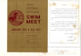
Album page
https://search.heritageburnaby.ca/link/museumartifact90367
- Repository
- Burnaby Village Museum
- Accession Code
- BV005.54.662
- Description
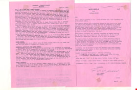
- Album page with flier and two notices. flier: red ink and photograph on brown card stock 28 x 21.5cm "Pacific Centennial Invitational Swim Meet January 30th & 31st 1971 / Simon Fraser University Pool..."; Notice: black and white copy on cartridge paper 23 x 15.5 cm with heading "--WELCOME--" and signed by The Burnaby Tyees Swimming Club Meet Director W.D. (Don) Purvis for Pacific Centennial Invitational Swim Meet January 30th & 31st 1971; Notice: black and white copy printed on cartridge paper 11 x 21.5 cm "THE BURNABY TYEES SWIMMING CLUB ACKNOWLEDGE WITH THANKS... THE BURNABY CENTENNIAL '71 COMMITTEE..."
- Object History
- Album page 134 from Don Copan album/scrapbook for Burnaby Centennial '71 celebrations
- Don Copan was an active member of the Burnaby Centennial ’71 Committee and later became the founding President of the Century Park Museum Association. While a member of the Burnaby Centennial ’71 Committee, Don created a scrapbook album of photographs and ephemera documenting the Burnaby Centennial ’71 Committee’s involvement in celebrating British Columbia’s Centenary of Confederation between January and December 1971 including Burnaby’s Commemorative Project – Heritage Village (Burnaby Village Museum).
- Reference
- Photographs from the Don Copan scrapbook/album are described as part of the Donald Copan collection - Copan Album series
- Category
- 08. Communication Artifacts
- Classification
- Documentary Artifacts - - Other Documents
- Object Term
- Leaflet
- Correspondence
Images

Album page
https://search.heritageburnaby.ca/link/museumartifact90380
- Repository
- Burnaby Village Museum
- Accession Code
- BV005.54.675
- Description
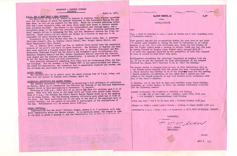
- Album page with two bulletins printed with black ink on pink cartridge paper; "Lynhurst - Cameron Schools / Bulletin / April 8, 1971"; "Easter Greetings / from / Douglas Gilpin" signed by F.H. Adler, principal.
- Object History
- Album page 147 from Don Copan album/scrapbook for Burnaby Centennial '71 celebrations
- Don Copan was an active member of the Burnaby Centennial ’71 Committee and later became the founding President of the Century Park Museum Association. While a member of the Burnaby Centennial ’71 Committee, Don created a scrapbook album of photographs and ephemera documenting the Burnaby Centennial ’71 Committee’s involvement in celebrating British Columbia’s Centenary of Confederation between January and December 1971 including Burnaby’s Commemorative Project – Heritage Village (Burnaby Village Museum).
- Reference
- Photographs from the Don Copan scrapbook/album are described as part of the Donald Copan collection - Copan Album series
- Category
- 08. Communication Artifacts
- Classification
- Documentary Artifacts - - Other Documents
- Object Term
- Leaflet
Images
Album page
https://search.heritageburnaby.ca/link/museumartifact90675
- Repository
- Burnaby Village Museum
- Accession Code
- BV005.54.740
- Description
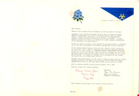
- Album page with type written letter on Burnaby Centennial "71 Committee stationery addressed to "Pioneer" re: an invitation to attend the Pioneer Medallion Presentation on May 9, 1971. ; signed by Mrs. Mary Trainer, Centennial Co-ordinator; regarding
- Object History
- Album page 212 from Don Copan album/scrapbook for Burnaby Centennial '71 celebrations
- Don Copan was an active member of the Burnaby Centennial ’71 Committee and later became the founding President of the Century Park Museum Association. While a member of the Burnaby Centennial ’71 Committee, Don created a scrapbook album of photographs and ephemera documenting the Burnaby Centennial ’71 Committee’s involvement in celebrating British Columbia’s Centenary of Confederation between January and December 1971 including Burnaby’s Commemorative Project – Heritage Village (Burnaby Village Museum).
- Reference
- Photographs from the Don Copan scrapbook/album are described as part of the Donald Copan collection - Copan Album series
- Category
- 08. Communication Artifacts
- Classification
- Documentary Artifacts - - Other Documents
- Object Term
- Correspondence
Images
Album page
https://search.heritageburnaby.ca/link/museumartifact90711
- Repository
- Burnaby Village Museum
- Accession Code
- BV005.54.747
- Description
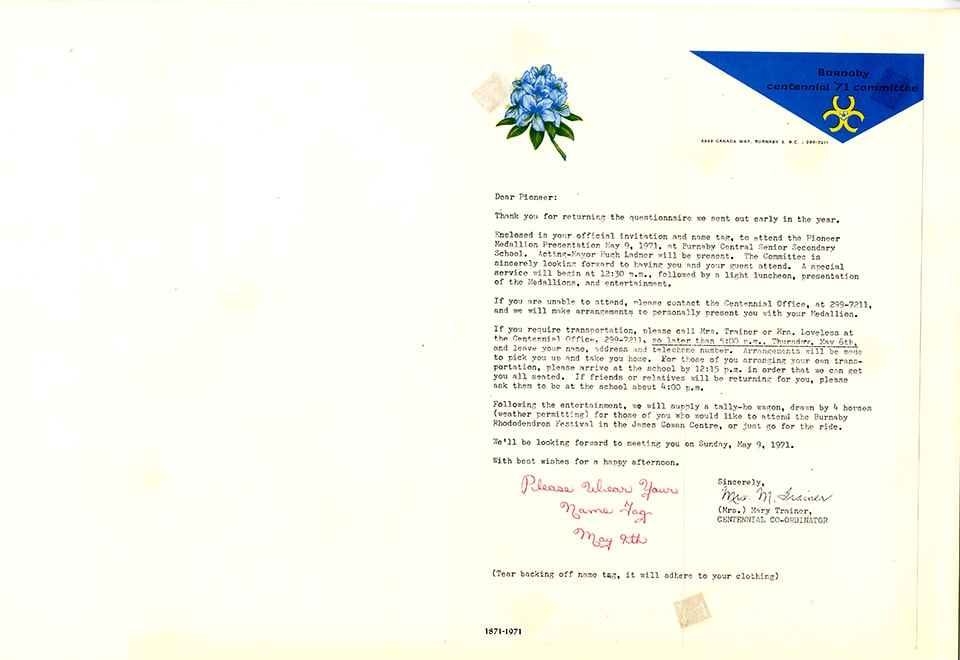
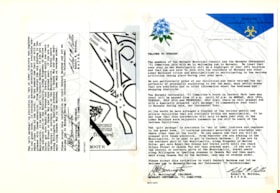
- Album page with two copies of doubled sided form letter from Burnaby Centennial '71 Committee; one side includes colour letterhead and heading "Welcome to Burnaby", signed by J.A. Barrington, Burnaby Centennial '71 Committee chairman; other side includes a map with title at bottom "Burnaby's salute to B.C. booth". Two copies are attached, to show both sides.
- Object History
- Album page 219 from Don Copan album/scrapbook for Burnaby Centennial '71 celebrations
- Don Copan was an active member of the Burnaby Centennial ’71 Committee and later became the founding President of the Century Park Museum Association. While a member of the Burnaby Centennial ’71 Committee, Don created a scrapbook album of photographs and ephemera documenting the Burnaby Centennial ’71 Committee’s involvement in celebrating British Columbia’s Centenary of Confederation between January and December 1971 including Burnaby’s Commemorative Project – Heritage Village (Burnaby Village Museum).
- Reference
- Photographs from the Don Copan scrapbook/album are described as part of the Donald Copan collection - Copan Album series
- Category
- 08. Communication Artifacts
- Classification
- Documentary Artifacts - - Other Documents
- Object Term
- Correspondence
- Subjects
- Celebrations - Centennials
Images
![A. MacKenzie and Company Jubilee Store, [1907 or 1908] thumbnail](/media/hpo/_Data/_BVM_Images/1985/1985_0024_0001_001.jpg?width=280)
A. MacKenzie and Company Jubilee Store
https://search.heritageburnaby.ca/link/museumdescription159
- Repository
- Burnaby Village Museum
- Date
- [1907 or 1908]
- Collection/Fonds
- Burnaby Village Museum Photograph collection
- Description Level
- Item
- Physical Description
- 1 photograph : b&w ; 9.8 x 14.0 cm, mounted on cardboard 13.2 x 18.8 cm
- Scope and Content
- Photograph of the exterior of a store on the ground floor of a two-storey building, with a sign painted on the front face of the second floor. It reads, "A. MacKenzie & Co / Jubilee Store." There are two men in suits standing out in front of the display windows that show stacks of boxes and cans.…
- Repository
- Burnaby Village Museum
- Collection/Fonds
- Burnaby Village Museum Photograph collection
- Description Level
- Item
- Physical Description
- 1 photograph : b&w ; 9.8 x 14.0 cm, mounted on cardboard 13.2 x 18.8 cm
- Scope and Content
- Photograph of the exterior of a store on the ground floor of a two-storey building, with a sign painted on the front face of the second floor. It reads, "A. MacKenzie & Co / Jubilee Store." There are two men in suits standing out in front of the display windows that show stacks of boxes and cans. The lot around the building looks vacant, but fenced. There is a wagon drawn by a team of two horses parked or travelling towards the store on the right side of the photograph. The store was owned by Alexander MacKenzie, (1870-1949) who arrived in Vancouver in 1907. There is a discrepancy in the date of the photograph; the accession register dates the photograph 1909 while the donation form signed by the donor dates all the photographs in the accession as 1907 or 1908. Annotations on the bottom front of the card mount read: "Ralph Libby" and "Vancouver B.C." This store later became the Matheson and Sons Market.
- Geographic Access
- Kingsway
- Nelson Avenue
- Accession Code
- BV985.24.1
- Access Restriction
- No restrictions
- Reproduction Restriction
- No known restrictions
- Date
- [1907 or 1908]
- Media Type
- Photograph
- Historic Neighbourhood
- Central Park (Historic Neighbourhood)
- Planning Study Area
- Marlborough Area
- Scan Resolution
- 600
- Scan Date
- 2023-12-19
- Photographer
- Libby, Ralph
- Notes
- Title based on contents of photograph
Images
![A. MacKenzie and Company Jubilee Store, [1907 or 1908] thumbnail](/media/hpo/_Data/_BVM_Images/1985/1985_0024_0001_001.jpg)

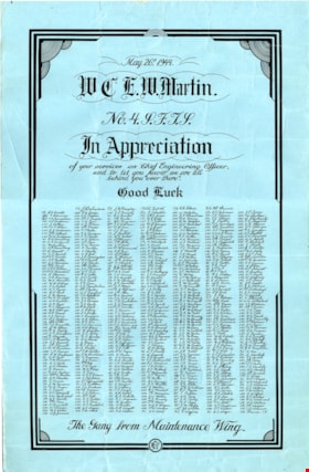
Appreciation certificate to Elmer Wilson Martin
https://search.heritageburnaby.ca/link/museumdescription15066
- Repository
- Burnaby Village Museum
- Date
- 26 May 1944
- Collection/Fonds
- Elmer Wilson Martin fonds
- Description Level
- Item
- Physical Description
- 1 certificate : lithographic print on blue paper ; 50.5 x 33 cm
- Scope and Content
- Item consists of a certificate of appreciation to WC E. W. Martin for his services as Chief Engineering Officer of the Royal Canadian Air Force. The certificate is signed by RCAF members of the maintenance wing wishing him luck while serving overseas.
- Repository
- Burnaby Village Museum
- Collection/Fonds
- Elmer Wilson Martin fonds
- Description Level
- Item
- Physical Description
- 1 certificate : lithographic print on blue paper ; 50.5 x 33 cm
- Scope and Content
- Item consists of a certificate of appreciation to WC E. W. Martin for his services as Chief Engineering Officer of the Royal Canadian Air Force. The certificate is signed by RCAF members of the maintenance wing wishing him luck while serving overseas.
- Accession Code
- BV019.37.11
- Access Restriction
- No restrictions
- Reproduction Restriction
- No known restrictions
- Date
- 26 May 1944
- Media Type
- Textual Record
- Scan Resolution
- 600
- Scan Date
- February 4, 2021
- Scale
- 100
- Notes
- Title based on contents of item
Images


Armstrong Street School site
https://search.heritageburnaby.ca/link/museumdescription11133
- Repository
- Burnaby Village Museum
- Date
- 1915
- Collection/Fonds
- Ronald G. Scobbie collection
- Description Level
- Item
- Physical Description
- 1 survey plan : blueprint on paper ; 56 x 54 cm
- Scope and Content
- Survey plan of "Armstrong Street School Site / Burnaby Municipality" "Being a 2 acre portion of Lot 13 Group 1, & according to map 1722 which shows this as Lot E. Block 2 of subdivision of a portion, of Lot 13, Group 1, New Westminster District".
- Repository
- Burnaby Village Museum
- Collection/Fonds
- Ronald G. Scobbie collection
- Description Level
- Item
- Physical Description
- 1 survey plan : blueprint on paper ; 56 x 54 cm
- Material Details
- Scale 40 feet = 1 inch
- Scope and Content
- Survey plan of "Armstrong Street School Site / Burnaby Municipality" "Being a 2 acre portion of Lot 13 Group 1, & according to map 1722 which shows this as Lot E. Block 2 of subdivision of a portion, of Lot 13, Group 1, New Westminster District".
- Creator
- Burnett, Geoffrey K.
- Subjects
- Buildings - Schools
- Names
- Armstrong Avenue School
- Responsibility
- Burnett & McGugan, Engineers and Surveyors
- Geographic Access
- Armstrong Avenue
- Street Address
- 8757 Armstrong Avenue
- Accession Code
- BV003.83.12
- Access Restriction
- No restrictions
- Reproduction Restriction
- No known restrictions
- Date
- 1915
- Media Type
- Cartographic Material
- Historic Neighbourhood
- East Burnaby (Historic Neighbourhood)
- Planning Study Area
- Cariboo-Armstrong Area
- Scan Resolution
- 440
- Scan Date
- 22-Dec-2020
- Scale
- 100
- Notes
- Title based on contents of plan
- Note in black ink on verso of plan reads: "1746"
- Oath on plan reads: "I, Geoffrey K. Burnett...and did personally superintend the survey represented..." "Completed on the 18th day of March 1915"; signed by Geoffrey K. Burnett and notarized by "K.A. Eastman", sworn "...19th day of April 1915"; "Burnett and McGugan., B.C. Land Surveyors. Etc.. New Westminster, B.C.."
Zoomable Images


Barnet School site
https://search.heritageburnaby.ca/link/museumdescription11140
- Repository
- Burnaby Village Museum
- Date
- May 27, 1915
- Collection/Fonds
- Ronald G. Scobbie collection
- Description Level
- Item
- Physical Description
- 1 survey plan : blueprint on paper ; 56 x 54 cm
- Scope and Content
- Survey plan of "Barnet School Site / Burnaby Municipality" "Being a portion of the west half of lot / 214, Group 1 / New Westminster District”.
- Repository
- Burnaby Village Museum
- Collection/Fonds
- Ronald G. Scobbie collection
- Description Level
- Item
- Physical Description
- 1 survey plan : blueprint on paper ; 56 x 54 cm
- Material Details
- Scale 40 feet = 1 inch
- Scope and Content
- Survey plan of "Barnet School Site / Burnaby Municipality" "Being a portion of the west half of lot / 214, Group 1 / New Westminster District”.
- Creator
- McGugan, Donald Johnston
- Subjects
- Buildings - Schools
- Names
- Barnet School
- Responsibility
- Burnett & McGugan, Engineers and Surveyors
- Geographic Access
- Barnet Road
- Street Address
- 7820 Barnet Road
- Accession Code
- BV003.83.19
- Access Restriction
- No restrictions
- Reproduction Restriction
- No known restrictions
- Date
- May 27, 1915
- Media Type
- Cartographic Material
- Historic Neighbourhood
- Barnet (Historic Neighbourhood)
- Planning Study Area
- Burnaby Mountain Area
- Scan Resolution
- 440
- Scan Date
- 22-Dec-2020
- Scale
- 100
- Notes
- Title based on contents of plan
- handwritten on back "Burnaby Schools" "23R" twice, "1783"
- Oath on plan reads: "I, D.J. McGugan...and did personally superintend the survey..." "completed on the 27th day of May 1915"; signed by D.J. McGugan, notarized by "Walter Edmonds" "sworn "...29th day of May 1915" "Burnett and McGugan" "B.C. Land Surveyors Etc. New Westminster, B.C.";
Zoomable Images

![Baseball team, [1929] thumbnail](/media/hpo/_Data/_BVM_Images/1985/1985_5755_0001_001.jpg?width=280)
Baseball team
https://search.heritageburnaby.ca/link/museumdescription1383
- Repository
- Burnaby Village Museum
- Date
- [1929]
- Collection/Fonds
- Burnaby Village Museum Photograph collection
- Description Level
- Item
- Physical Description
- 1 photograph : b&w
- Scope and Content
- The photograph shows 11 men posed together in what appears to be a baseball field. 7 of 11 men are wearing baseball uniforms. Most of them have or are wearing baseball gloves. The signatures on the back of the photograph may correspond to the identity of the men in the photograph. They are: D. Hamm…
- Repository
- Burnaby Village Museum
- Collection/Fonds
- Burnaby Village Museum Photograph collection
- Description Level
- Item
- Physical Description
- 1 photograph : b&w
- Material Details
- stamped verso, u.l. "PHOTO BY/ C. J. Lord", inscribed in black ink, each line signed in different hands, " D. Hammell/ R. Wilson/ Martin L. Dalen/ Ed Marriott/ Wilf Mains [or Mairs]/ D. Bird/ W. Sobbs [or Gibbs]/ R. J. Pelchat [or Pelcher]"
- Scope and Content
- The photograph shows 11 men posed together in what appears to be a baseball field. 7 of 11 men are wearing baseball uniforms. Most of them have or are wearing baseball gloves. The signatures on the back of the photograph may correspond to the identity of the men in the photograph. They are: D. Hammell, R. Wilson, Martin L. Dalen, Ed Marriott, Wilf Mains (or Mairs), D. Bird, W. Sobbs (or Gibbs), R. J. Pelchat (or Pelcher).
- Subjects
- Sports - Baseball
- Sports - Team Sports
- Accession Code
- BV985.5755.1
- Access Restriction
- No restrictions
- Reproduction Restriction
- No known restrictions
- Date
- [1929]
- Media Type
- Photograph
- Scan Resolution
- 600
- Scan Date
- 2024-01-23
- Photographer
- Lord, C.J.
- Notes
- Title based on contents of photograph
Images
![Baseball team, [1929] thumbnail](/media/hpo/_Data/_BVM_Images/1985/1985_5755_0001_001.jpg)
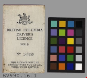
B C driver's licence
https://search.heritageburnaby.ca/link/museumartifact2814
- Repository
- Burnaby Village Museum
- Accession Code
- BV990.16.1
- Description
- British Columbia Driver's Licence - License -- [1928]. Driver's Licence issued to Jean Caldwell Thompson on August 8, 1928. The front cover has the Provincial Coat of Arms and the issue number for the licence "No. 144650". The fee for obtaining the licence was $1. It states that "The Licence Must Be Carried With You At All Times When Driving". Inside provides detailed information about Jean and rules and regulations to driving. The address given for Jean was "General Hospital Vancouver". The license has been stamped by the Provincial Police in Vancouver, B.C. and signed by Superintendent of the Provincial Police E. McArthur. The licence measures 6.5cm x 10cm.
- Colour
- White
Images


