Narrow Results By
Subject
- Buildings - Civic - Fire Halls 4
- Buildings - Residential - Houses 2
- Clothing - Uniforms 3
- Events - Fundraising 1
- Geographic Features - Neighbourhoods 1
- Occupations - Fire Fighters 3
- Persons - Volunteers 1
- Planning - City Planning 1
- Public Services - Municipal Services 1
- Public Services - Policing 1
- Recreational Activities 1
- Transportation - Fire Trucks 1

James & Mary Herd Residence
https://search.heritageburnaby.ca/link/landmark604
- Repository
- Burnaby Heritage Planning
- Description
- Residential building.
- Associated Dates
- 1910
- Other Names
- STRATHMORE
- Street View URL
- Google Maps Street View
- Repository
- Burnaby Heritage Planning
- Other Names
- STRATHMORE
- Geographic Access
- Boundary Road North
- Associated Dates
- 1910
- Description
- Residential building.
- Heritage Value
- Designed for James Herd (1863-1940) and his wife, Mary Jane Barrie Herd (née Fenton, 1870-1956), this house was described “as a fine new home valued at… $7,000” by The British Columbian in 1912. Named after Mrs. Herd’s birthplace in the Strathmore Valley, Scotland, this was one of the first homes to be built in the Vancouver Heights subdivision. A full width verandah takes advantage of remarkable views of downtown Vancouver and Burrard Inlet. Though the architecture of the house has been altered by the addition of stucco cladding and the replacement of the original windows, it remains an excellent example of the Craftsman style, with the triangular eave brackets, granite clad verandah piers, square support columns and varied roofline with broad eaves that are characteristic of the style. It was the long-time residence of Joseph Wellington Kelly (1876-1962), a stationary engineer, and his wife Margaret Ann Kelly (née Allan, 1880-1968), who were married in Vancouver in 1901. Their son, Allan C. Kelly (died 2001) was an architect, who worked for the architectural firm Townley & Matheson from 1928 until the 1970s. Among many other projects undertaken for the firm, Allan Kelly was the project architect for Vancouver City Hall.
- Locality
- Vancouver Heights
- Historic Neighbourhood
- Vancouver Heights (Historic Neighbourhood)
- Planning Study Area
- Burnaby Heights Area
- Area
- 708.39
- Contributing Resource
- Building
- Ownership
- Private
- Street Address
- 510 Boundary Road North
- Street View URL
- Google Maps Street View
Images


Lewis & Millicent Physick Residence
https://search.heritageburnaby.ca/link/landmark616
- Repository
- Burnaby Heritage Planning
- Description
- Residential building.
- Associated Dates
- 1939
- Street View URL
- Google Maps Street View
- Repository
- Burnaby Heritage Planning
- Geographic Access
- Boundary Road North
- Associated Dates
- 1939
- Description
- Residential building.
- Heritage Value
- This modest residence was built for Lewis Baker Physick (1905-1971), a freight dispatcher for B.C. Motor Transport Company who later worked for B.C. Hydro, and Millicent Physick (née Edwards, 1894-1971), a hairdresser, who lived here until their respective deaths. Situated on a terraced lot with stone-clad retaining walls, this home was influenced by the British Arts and Crafts style, which remained popular throughout the 1930s. Such stylistic influence can be seen in the second floor overhang, which is supported by false beams, leaded casement windows and steeply pitched roof and front gable. The roofline is enhanced by a jerkin-headed roof on the front gable. Apart from the addition of a later south elevation extension, the house remains in excellent original condition. Located on an elevated site, this residence has an unobstructed view of downtown Vancouver and Burrard Inlet.
- Locality
- Vancouver Heights
- Historic Neighbourhood
- Vancouver Heights (Historic Neighbourhood)
- Planning Study Area
- Burnaby Heights Area
- Area
- 566.71
- Contributing Resource
- Building
- Ownership
- Private
- Street Address
- 420 Boundary Road North
- Street View URL
- Google Maps Street View
Images


Lucy Turner Residence
https://search.heritageburnaby.ca/link/landmark618
- Repository
- Burnaby Heritage Planning
- Description
- Residential building.
- Associated Dates
- 1930
- Street View URL
- Google Maps Street View
- Repository
- Burnaby Heritage Planning
- Geographic Access
- Boundary Road North
- Associated Dates
- 1930
- Description
- Residential building.
- Heritage Value
- This house was built for Lucy Lillian Turner (1881-1959), the daughter of Captain Andrew Jackson Cates of North Vancouver. Lucy Turner was the widow of Robert Ketchson Turner (1871-1918), who was a purser for her father’s Terminal Steam Navigation Company. They were married in 1913; Robert died during the 1918 Spanish Influenza epidemic and was buried at Mountain View Cemetery in Vancouver. Located on an elevated site, this residence boasts an unobstructed view of downtown Vancouver and Burrard Inlet and is situated amidst a context of homes of a similar age and scale. Demonstrating the late influence of the Craftsman style, this one and one-half storey house has triangular eave brackets and exposed rafter tails and purlins. A central wall dormer projects over the central front entry. Though the integrity of the house has been compromised with a later coat of stucco over the original siding, it maintains its double-hung wooden windows and original form, scale and massing.
- Locality
- Vancouver Heights
- Historic Neighbourhood
- Vancouver Heights (Historic Neighbourhood)
- Planning Study Area
- Burnaby Heights Area
- Area
- 566.71
- Contributing Resource
- Building
- Ownership
- Private
- Street Address
- 324 Boundary Road North
- Street View URL
- Google Maps Street View
Images


Mary Sutcliffe Residence
https://search.heritageburnaby.ca/link/landmark621
- Repository
- Burnaby Heritage Planning
- Description
- Residential building.
- Associated Dates
- c.1930
- Street View URL
- Google Maps Street View
- Repository
- Burnaby Heritage Planning
- Geographic Access
- Boundary Road North
- Associated Dates
- c.1930
- Description
- Residential building.
- Heritage Value
- Built at a time when historical styles were favoured for domestic construction, this charming cottage residence was built for Mary Seymour Sutcliffe (1870-1959), the wife of retired painter Arthur Sutcliffe (1863-1932). It was inspired by the British Arts and Crafts movement, as displayed in the half-timbering, rounded door hood and the picturesque, jerkin-headed roof with exposed purlins. While this house has a Boundary Road address, the house faces north instead of west, facing an elevated and extraordinary view of Burrard Inlet.
- Locality
- Vancouver Heights
- Historic Neighbourhood
- Vancouver Heights (Historic Neighbourhood)
- Planning Study Area
- Burnaby Heights Area
- Area
- 566.71
- Contributing Resource
- Building
- Ownership
- Private
- Street Address
- 650 Boundary Road North
- Street View URL
- Google Maps Street View
Images

![Burnaby Heights On the Run event, [2002] thumbnail](/media/hpo/_Data/_Archives_Images/_Unrestricted/535/535-2793-1.jpg?width=280)
Burnaby Heights On the Run event
https://search.heritageburnaby.ca/link/archivedescription97433
- Repository
- City of Burnaby Archives
- Date
- [2002]
- Collection/Fonds
- Burnaby NewsLeader photograph collection
- Description Level
- File
- Physical Description
- 2 photographs (tiff) : col.
- Scope and Content
- File contains photographs of the first annual Burnaby Heights On the Run charity walk and run on Hastings Street. Photographs depict fire fighters from Fire Hall No. 5 cheering on participants and a crowd of participants at the events' starting line.
- Repository
- City of Burnaby Archives
- Date
- [2002]
- Collection/Fonds
- Burnaby NewsLeader photograph collection
- Physical Description
- 2 photographs (tiff) : col.
- Description Level
- File
- Record No.
- 535-2793
- Access Restriction
- No restrictions
- Reproduction Restriction
- No restrictions
- Accession Number
- 2018-12
- Scope and Content
- File contains photographs of the first annual Burnaby Heights On the Run charity walk and run on Hastings Street. Photographs depict fire fighters from Fire Hall No. 5 cheering on participants and a crowd of participants at the events' starting line.
- Names
- Burnaby Fire Department
- Media Type
- Photograph
- Photographer
- Bartel, Mario
- Notes
- Title based on caption
- Collected by editorial for use in a September 2002 issue of the Burnaby NewsLeader
- Caption from metadata for 535-2793-1: "Burnaby firefighters at Hall 5, on Hastings St., cheer on participants in first annual Burnaby Heights On The Run charity run and walk. Proceeds from the event go to the Burnaby Firefighters' Charitable Foundation."
- Caption from metadata for 535-2793-2: "More than 200 runners and walkers set off on the first annual Burnaby Heights On The Run, on Saturday. Proceeds from the event, which included courses of five and ten kilometers, go to the Burnaby Firefighters' Charitable Foudation."
- Geographic Access
- Hastings Street
- Carleton Avenue
- Historic Neighbourhood
- Vancouver Heights (Historic Neighbourhood)
- Planning Study Area
- Burnaby Heights Area
Images
![Burnaby Heights On the Run event, [2002] thumbnail](/media/hpo/_Data/_Archives_Images/_Unrestricted/535/535-2793-1.jpg)

Burnaby Heights "panhandling meter"
https://search.heritageburnaby.ca/link/archivedescription97994
- Repository
- City of Burnaby Archives
- Date
- [2000]
- Collection/Fonds
- Burnaby NewsLeader photograph collection
- Description Level
- File
- Physical Description
- 2 photographs (tiff) : col.
- Scope and Content
- File contains photographs of Mark, a panhandler, on Hastings Street by a "panhandling meter" installed by the City of Burnaby. The meter reads: "This is not a parking meter / Spare change for social change."
- Repository
- City of Burnaby Archives
- Date
- [2000]
- Collection/Fonds
- Burnaby NewsLeader photograph collection
- Physical Description
- 2 photographs (tiff) : col.
- Description Level
- File
- Record No.
- 535-3098
- Access Restriction
- No restrictions
- Reproduction Restriction
- No restrictions
- Accession Number
- 2018-12
- Scope and Content
- File contains photographs of Mark, a panhandler, on Hastings Street by a "panhandling meter" installed by the City of Burnaby. The meter reads: "This is not a parking meter / Spare change for social change."
- Media Type
- Photograph
- Photographer
- Bartel, Mario
- Notes
- Title based on caption
- Collected by editorial for use in a February 2000 issue of the Burnaby NewsLeader
- Caption from metadata for 535-3098-1: "Mark says he panhandles along Hastings St. when he's hungry and can't afford food. He says the new meters haven't affected his take."
- Caption from metadata for 535-3098-2: "The new spare change meters haven't disuaded panhandlers, like Mark, from setting up shop along Hastings St. He says he panhandles when he needs money for food."
- Geographic Access
- Hastings Street
- Carleton Avenue
- Historic Neighbourhood
- Vancouver Heights (Historic Neighbourhood)
- Planning Study Area
- Burnaby Heights Area
Images

![Ed McDonald family home, [1910] thumbnail](/media/hpo/_Data/_Archives_Images/_Unrestricted/316/319-001.jpg?width=280)
Ed McDonald family home
https://search.heritageburnaby.ca/link/archivedescription37110
- Repository
- City of Burnaby Archives
- Date
- [1910]
- Collection/Fonds
- Burnaby Historical Society fonds
- Description Level
- Item
- Physical Description
- 1 photograph : sepia ; 8 x 13 cm
- Scope and Content
- Photograph of Ed McDonald's family home at 702 N. Boundary Rd. A signpost for Edinburgh Street is visible on the left.
- Repository
- City of Burnaby Archives
- Date
- [1910]
- Collection/Fonds
- Burnaby Historical Society fonds
- Subseries
- Photographs subseries
- Physical Description
- 1 photograph : sepia ; 8 x 13 cm
- Description Level
- Item
- Record No.
- 319-001
- Access Restriction
- No restrictions
- Reproduction Restriction
- No known restrictions
- Accession Number
- BHS1995-12
- Scope and Content
- Photograph of Ed McDonald's family home at 702 N. Boundary Rd. A signpost for Edinburgh Street is visible on the left.
- Subjects
- Buildings - Residential - Houses
- Media Type
- Photograph
- Notes
- Title based on contents of photograph
- Geographic Access
- Boundary Road North
- Edinburgh Street
- Street Address
- 702 Boundary Road North
- Historic Neighbourhood
- Vancouver Heights (Historic Neighbourhood)
- Planning Study Area
- Burnaby Heights Area
Images
![Ed McDonald family home, [1910] thumbnail](/media/hpo/_Data/_Archives_Images/_Unrestricted/316/319-001.jpg)

Firefighters Albert Killer and Fred Blake
https://search.heritageburnaby.ca/link/museumdescription1294
- Repository
- Burnaby Village Museum
- Date
- 1939 (date of original)
- Collection/Fonds
- Burnaby Village Museum Photograph collection
- Description Level
- Item
- Physical Description
- 1 photograph : b&w ; 8.5 x 15 cm print
- Scope and Content
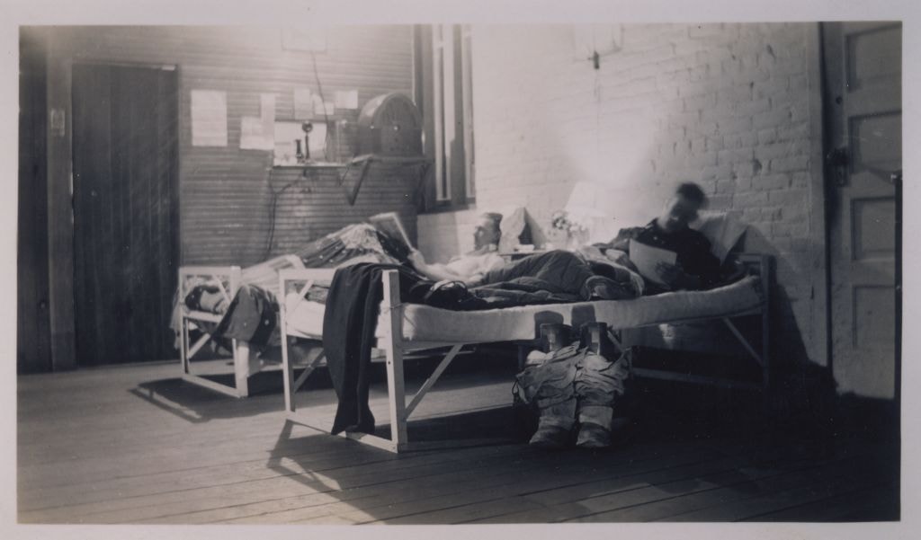
- Photograph of Firefighters Albert Killer and Fred Blake lying down on their beds and reading (in the dormitory during the night shift) at No. 1 Burnaby Fire Hall at Carleton Avenue and Eton Street. Fire boots (with fire resistant pants gathered over them) are visible at the side of Fred Blake's bed.
- Repository
- Burnaby Village Museum
- Collection/Fonds
- Burnaby Village Museum Photograph collection
- Description Level
- Item
- Physical Description
- 1 photograph : b&w ; 8.5 x 15 cm print
- Material Details
- .
- Scope and Content
- Photograph of Firefighters Albert Killer and Fred Blake lying down on their beds and reading (in the dormitory during the night shift) at No. 1 Burnaby Fire Hall at Carleton Avenue and Eton Street. Fire boots (with fire resistant pants gathered over them) are visible at the side of Fred Blake's bed.
- Geographic Access
- Carleton Avenue
- Eton Street
- Accession Code
- BV998.31.3
- Access Restriction
- No restrictions
- Reproduction Restriction
- No known restrictions
- Date
- 1939 (date of original)
- Media Type
- Photograph
- Historic Neighbourhood
- Vancouver Heights (Historic Neighbourhood)
- Planning Study Area
- Burnaby Heights Area
- Scan Resolution
- 600
- Scan Date
- 02-Jun-09
- Scale
- 100
- Notes
- Title based on contents of photograph
- Typed sticker on verso of photograph reads: "Night shift at No.1 Hall/ Carleton Ave. and Eton St. (L) Albert Killer (R) Fred Blake 1939"
- Address sticker on verso of photograph reads: "MR & MRS F BLAKE 4165 PANDORA ST BURNABY BC V5C 2B2"
Images
![Firefighters Albert Killer, Gordon Monk and Wendell Walyer, [1942] (date of original) thumbnail](/media/hpo/_Data/_BVM_Images/1990/199800310017.jpg?width=280)
Firefighters Albert Killer, Gordon Monk and Wendell Walyer
https://search.heritageburnaby.ca/link/museumdescription1302
- Repository
- Burnaby Village Museum
- Date
- [1942] (date of original)
- Collection/Fonds
- Burnaby Village Museum Photograph collection
- Description Level
- Item
- Physical Description
- 1 photograph : b&w ; 8 x 14 cm print
- Scope and Content
- Photograph of a Ford triple combination fire truck stationed outside the former Fire hall no. 1 on Carleton Avenue near Eton Street. Firefighters Albert Killer, Gordon Monk and Wendell Walyer (not in uniform) are standing at the truck, looking towards the camera.
- Repository
- Burnaby Village Museum
- Collection/Fonds
- Burnaby Village Museum Photograph collection
- Description Level
- Item
- Physical Description
- 1 photograph : b&w ; 8 x 14 cm print
- Scope and Content
- Photograph of a Ford triple combination fire truck stationed outside the former Fire hall no. 1 on Carleton Avenue near Eton Street. Firefighters Albert Killer, Gordon Monk and Wendell Walyer (not in uniform) are standing at the truck, looking towards the camera.
- Subjects
- Occupations - Fire Fighters
- Clothing - Uniforms
- Transportation - Fire Trucks
- Buildings - Civic - Fire Halls
- Geographic Access
- Carleton Avenue
- Eton Street
- Accession Code
- BV998.31.17
- Access Restriction
- No restrictions
- Reproduction Restriction
- No known restrictions
- Date
- [1942] (date of original)
- Media Type
- Photograph
- Historic Neighbourhood
- Vancouver Heights (Historic Neighbourhood)
- Planning Study Area
- Burnaby Heights Area
- Scan Resolution
- 600
- Scan Date
- 01-Jun-09
- Scale
- 100
- Notes
- Title based on contents of photograph
- Typed sticker on verso of photograph reads: "Truck bay in former pump house. 290 N. Carleton/ 1942 FORD Triple combina-tion. (L) A. Killer/ G. Monk W. Walyer"
- Address sticker on verso of photograph reads: "MR & MRS F BLAKE 4165 PANDORA ST BURNABY BC V5C 2B2"
Images
![Firefighters Albert Killer, Gordon Monk and Wendell Walyer, [1942] (date of original) thumbnail](/media/hpo/_Data/_BVM_Images/1990/199800310017.jpg)
Firefighters Harry Anderson, Leo Fraser, Fred Blake and Henry Chapman
https://search.heritageburnaby.ca/link/museumdescription2625
- Repository
- Burnaby Village Museum
- Date
- 1940
- Collection/Fonds
- Burnaby Village Museum Photograph collection
- Description Level
- Item
- Physical Description
- 1 photograph : b&w ; 6 x 10.5 cm
- Scope and Content
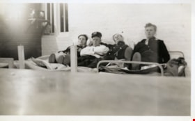
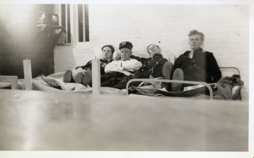
- Photograph of Firefighters Harry Anderson, Leo Fraser, Fred Blake and Henry Chapman lying down on their beds in the dormitory at No. 1 Burnaby Fire Hall at Carleton Avenue and Eton Street. This photograph was taken by Fred Blake using a box camera with a five minute exposure (so that he was able to…
- Repository
- Burnaby Village Museum
- Collection/Fonds
- Burnaby Village Museum Photograph collection
- Description Level
- Item
- Physical Description
- 1 photograph : b&w ; 6 x 10.5 cm
- Scope and Content
- Photograph of Firefighters Harry Anderson, Leo Fraser, Fred Blake and Henry Chapman lying down on their beds in the dormitory at No. 1 Burnaby Fire Hall at Carleton Avenue and Eton Street. This photograph was taken by Fred Blake using a box camera with a five minute exposure (so that he was able to run and put himself into the shot before the shutter closed).
- Geographic Access
- Carleton Avenue
- Eton Street
- Accession Code
- BV002.75.6
- Access Restriction
- Restricted access
- Reproduction Restriction
- May be restricted by third party rights
- Date
- 1940
- Media Type
- Photograph
- Historic Neighbourhood
- Vancouver Heights (Historic Neighbourhood)
- Planning Study Area
- Burnaby Heights Area
- Scan Resolution
- 600
- Scan Date
- 1/12/2010
- Scale
- 100
- Photographer
- Blake, Frederick "Fred"
- Notes
- Title based on contents of photograph
- Quote from letter of Aug. 15, 2002 from Fred Blake (letter in accession file): "With reference to the enclosed picture where I am stretched out on the bed. All my early pictures were taken with a box camera that I still have. With the slow film and poor room lighting I knew it would have to be a five minute time exposure. There was no automatic timer on the box camera. You had to press the shutter button to open the lens and again to close it. With this length of exposure I knew that if I moved quickly I could be in the picture. I had the others propped up and opened the lens and ran across and took my place on the bed. When I fell back I realized that I had forgotten a back rest for myself. I stayed that way for five minutes as I didn't want to take a chance of spoiling the picture. When the time was up I ran across the room and closed the lens. I was pleased that the picture tuned out alright, but a little disappointed about me."
- Handwritten note on verso of photograph reads: "I had to hang on to FRASER so that I wouldn't fall off the bed. / 658X / 1940 No.1 HALL 290 N. CARLETON / HARRY ANDERSON LEO FRASER FRED BLAKE HENRY CHAPMAN / L TO R"
Images
![Fire hall no. 1, [1925] (date of original) thumbnail](/media/hpo/_Data/_BVM_Images/1990/199800310005.jpg?width=280)
Fire hall no. 1
https://search.heritageburnaby.ca/link/museumdescription1296
- Repository
- Burnaby Village Museum
- Date
- [1925] (date of original)
- Collection/Fonds
- Burnaby Village Museum Photograph collection
- Description Level
- Item
- Physical Description
- 1 photograph : b&w ; 10 x 15 cm print
- Scope and Content
- Photograph of North Burnaby's first fire hall (the building was originally used as a pump house before it was converted).
- Repository
- Burnaby Village Museum
- Collection/Fonds
- Burnaby Village Museum Photograph collection
- Description Level
- Item
- Physical Description
- 1 photograph : b&w ; 10 x 15 cm print
- Scope and Content
- Photograph of North Burnaby's first fire hall (the building was originally used as a pump house before it was converted).
- Subjects
- Buildings - Civic - Fire Halls
- Names
- Burnaby Fire Department
- Geographic Access
- Carleton Avenue
- Eton Street
- Accession Code
- BV998.31.5
- Access Restriction
- No restrictions
- Reproduction Restriction
- No known restrictions
- Date
- [1925] (date of original)
- Media Type
- Photograph
- Historic Neighbourhood
- Vancouver Heights (Historic Neighbourhood)
- Planning Study Area
- Burnaby Heights Area
- Scan Resolution
- 600
- Scan Date
- 01-Jun-09
- Scale
- 100
- Photographer
- Blake, Frederick "Fred"
- Notes
- Title based on contents of photograph
- Typed sticker on verso of photograph reads: "Burnaby's first fire hall Carleton Ave. and Eton St. 290 N (1925)"
- Address sticker on verso of photograph reads: "MR & MRS F BLAKE 4165 PANDORA ST BURNABY BC V5C 2B2"
Images
![Fire hall no. 1, [1925] (date of original) thumbnail](/media/hpo/_Data/_BVM_Images/1990/199800310005.jpg)
![North Burnaby Speedwatch volunteers, [2001] thumbnail](/media/hpo/_Data/_Archives_Images/_Unrestricted/535/535-2944.jpg?width=280)
North Burnaby Speedwatch volunteers
https://search.heritageburnaby.ca/link/archivedescription97648
- Repository
- City of Burnaby Archives
- Date
- [2001]
- Collection/Fonds
- Burnaby NewsLeader photograph collection
- Description Level
- Item
- Physical Description
- 1 photograph (tiff) : col.
- Scope and Content
- Photograph of Jennifer Marchuk and Jim Campbell, volunteer co-ordinators for the Speedwatch program in North Burnaby, practicing using a radar gun in front of Carleton Plaza on Hastings Street.
- Repository
- City of Burnaby Archives
- Date
- [2001]
- Collection/Fonds
- Burnaby NewsLeader photograph collection
- Physical Description
- 1 photograph (tiff) : col.
- Description Level
- Item
- Record No.
- 535-2944
- Access Restriction
- No restrictions
- Reproduction Restriction
- No restrictions
- Accession Number
- 2018-12
- Scope and Content
- Photograph of Jennifer Marchuk and Jim Campbell, volunteer co-ordinators for the Speedwatch program in North Burnaby, practicing using a radar gun in front of Carleton Plaza on Hastings Street.
- Media Type
- Photograph
- Photographer
- Bartel, Mario
- Notes
- Title based on caption
- Collected by editorial for use in a November 2001 issue of the Burnaby NewsLeader
- Caption from metadata: "Jennifer Marchuk and Jim Campbell, volunteer co-ordinators for the Speedwatch program in North Burnaby, get in some practice time with the radar gun."
- Geographic Access
- Hastings Street
- Carleton Avenue
- Historic Neighbourhood
- Vancouver Heights (Historic Neighbourhood)
- Planning Study Area
- Burnaby Heights Area
Images
![North Burnaby Speedwatch volunteers, [2001] thumbnail](/media/hpo/_Data/_Archives_Images/_Unrestricted/535/535-2944.jpg)

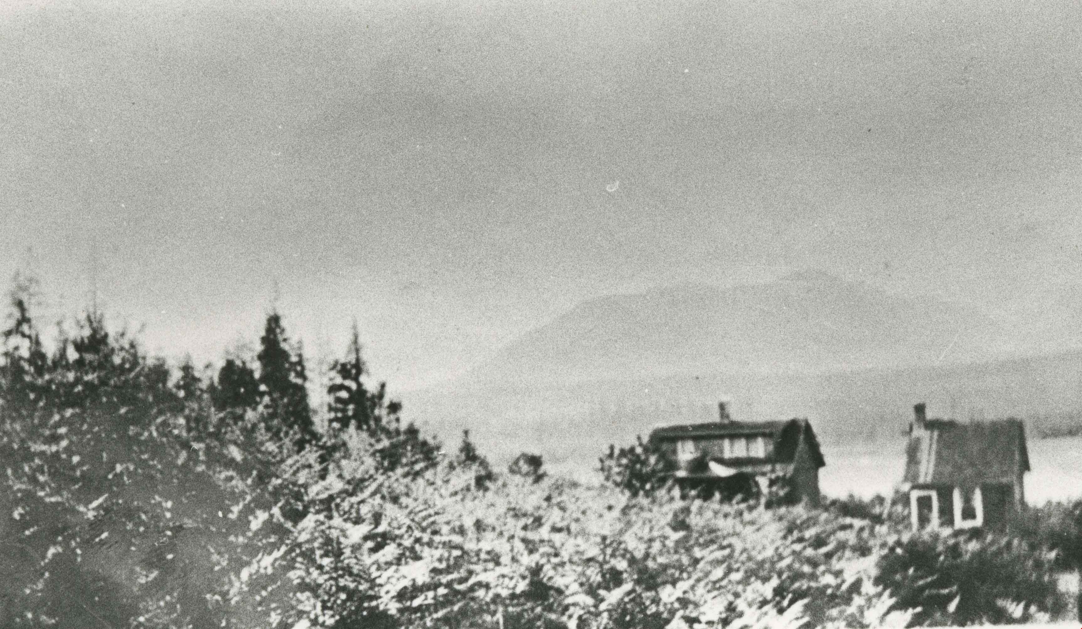
Vancouver Heights area
https://search.heritageburnaby.ca/link/archivedescription35266
- Repository
- City of Burnaby Archives
- Date
- 1911 (date of original), copied 1986
- Collection/Fonds
- Burnaby Historical Society fonds
- Description Level
- Item
- Physical Description
- 1 photograph : b&w ; 12.7 x 17.8 cm print
- Scope and Content
- Photograph of Carleton Avenue and Yale Street area in the neighbourhood where David Taylor and Henry Ward built their duplex for their families in 1911, when they emigrated from England. Both families had two children: Douglas and Hilda Ward, and Marjorie and Winnie Taylor.
- Repository
- City of Burnaby Archives
- Date
- 1911 (date of original), copied 1986
- Collection/Fonds
- Burnaby Historical Society fonds
- Subseries
- Pioneer Tales subseries
- Physical Description
- 1 photograph : b&w ; 12.7 x 17.8 cm print
- Description Level
- Item
- Record No.
- 204-123
- Access Restriction
- No restrictions
- Reproduction Restriction
- No known restrictions
- Accession Number
- BHS1988-03
- Scope and Content
- Photograph of Carleton Avenue and Yale Street area in the neighbourhood where David Taylor and Henry Ward built their duplex for their families in 1911, when they emigrated from England. Both families had two children: Douglas and Hilda Ward, and Marjorie and Winnie Taylor.
- Subjects
- Geographic Features - Neighbourhoods
- Media Type
- Photograph
- Notes
- Title based on contents of photograph
- Geographic Access
- Carleton Avenue
- Yale Street
- Historic Neighbourhood
- Vancouver Heights (Historic Neighbourhood)
- Planning Study Area
- Burnaby Heights Area
Images
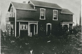
Ward-Taylor duplex
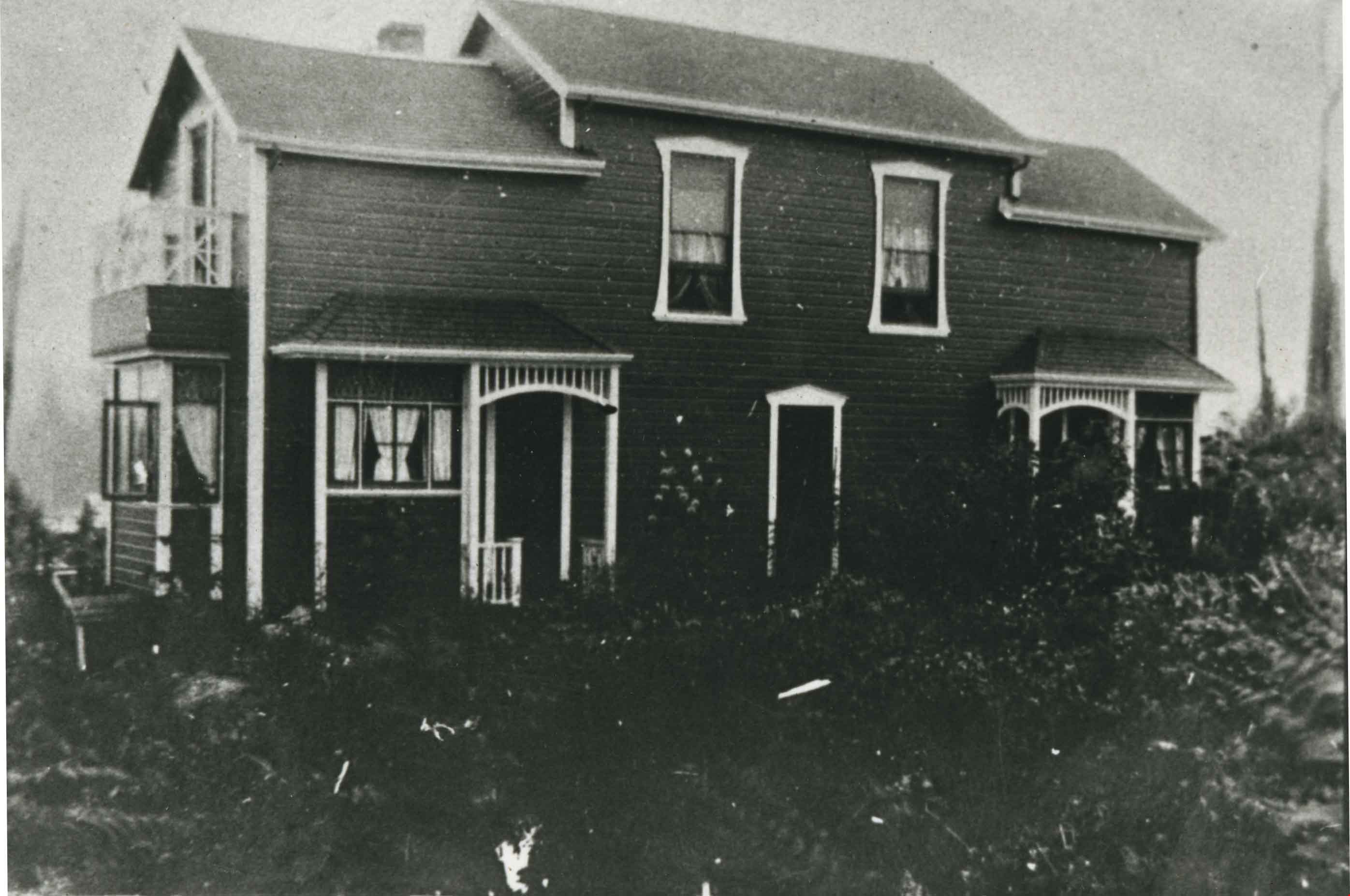
https://search.heritageburnaby.ca/link/archivedescription35265
- Repository
- City of Burnaby Archives
- Date
- 1911
- Collection/Fonds
- Burnaby Historical Society fonds
- Description Level
- Item
- Physical Description
- 1 photograph : b&w ; 12.7 x 17.8 cm print
- Scope and Content
- Photograph of a duplex built at 4208 McGill Street on the corner of Carleton Avenue and McGill, North Burnaby. This duplex was built by friends David Taylor (wife: Emily Taylor) and Henry Ward for their families in 1911, when they emigrated from England. Both families had two children: Douglas an…
- Repository
- City of Burnaby Archives
- Date
- 1911
- Collection/Fonds
- Burnaby Historical Society fonds
- Subseries
- Pioneer Tales subseries
- Physical Description
- 1 photograph : b&w ; 12.7 x 17.8 cm print
- Description Level
- Item
- Record No.
- 204-122
- Access Restriction
- No restrictions
- Reproduction Restriction
- No known restrictions
- Accession Number
- BHS1988-03
- Scope and Content
- Photograph of a duplex built at 4208 McGill Street on the corner of Carleton Avenue and McGill, North Burnaby. This duplex was built by friends David Taylor (wife: Emily Taylor) and Henry Ward for their families in 1911, when they emigrated from England. Both families had two children: Douglas and Hilda Ward, and Marjorie and Winnie Taylor.
- Subjects
- Buildings - Residential - Houses
- Media Type
- Photograph
- Notes
- Title based on contents of photograph
- Geographic Access
- Carleton Avenue
- McGill Street
- Historic Neighbourhood
- Vancouver Heights (Historic Neighbourhood)
- Planning Study Area
- Burnaby Heights Area
Images