Narrow Results By
Subject
- Accidents - Automobile Accidents 1
- Advertising Medium - Signs and Signboards 17
- Agriculture - Farms 1
- Animals - Cats 1
- Buildings - Civic - Art Galleries 2
- Buildings - Civic - Fire Halls 1
- Buildings - Civic - Hospitals 5
- Buildings - Civic - Libraries 1
- Buildings - Civic - Museums 9
- Buildings - Commercial 2
- Buildings - Commercial - Bakeries 4
- Buildings - Commercial - Department Stores 4
Person / Organization
- Admiral Hotel 1
- Bancroft, Rose 3
- Barnet Mill 1
- Barnet Rifle Club 1
- Bird, Gloriana "Birdie" 1
- Brentwood Shopping Centre 3
- Brice, Miss 1
- British Columbia Electric Railway Company 1
- British Columbia Hydro and Power Authority 1
- British Columbia Institute of Technology 1
- Brown, Mr 1
- Burnaby Art Gallery 2
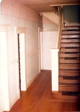
![6664 Deer Lake Avenue entrance hall, [1979] thumbnail](/media/hpo/_Data/_Archives_Images/_Unrestricted/600/625-030.jpg?width=280)
6664 Deer Lake Avenue entrance hall
https://search.heritageburnaby.ca/link/archivedescription95602
- Repository
- City of Burnaby Archives
- Date
- [1979]
- Collection/Fonds
- City of Burnaby Archives photograph collection
- Description Level
- Item
- Physical Description
- 1 photograph (tiff)
- Scope and Content
- Photograph of the entrance hall in 6664 Deer Lake Avenue (formerly the F.J. Hart Estate "Avalon"; now Hart House). This photograph was taken prior to the City of Burnaby’s purchase of the home in 1979. The photograph depicts the entrance hall's large fireplace and multiple rugs.
- Repository
- City of Burnaby Archives
- Date
- [1979]
- Collection/Fonds
- City of Burnaby Archives photograph collection
- Physical Description
- 1 photograph (tiff)
- Description Level
- Item
- Record No.
- 625-030
- Access Restriction
- No restrictions
- Reproduction Restriction
- Reproduce for fair dealing purposes only
- Accession Number
- 2021-10
- Scope and Content
- Photograph of the entrance hall in 6664 Deer Lake Avenue (formerly the F.J. Hart Estate "Avalon"; now Hart House). This photograph was taken prior to the City of Burnaby’s purchase of the home in 1979. The photograph depicts the entrance hall's large fireplace and multiple rugs.
- Subjects
- Buildings - Heritage
- Media Type
- Photograph
- Notes
- Title based on caption
- Caption was added during digitization.
- Geographic Access
- Deer Lake
- Street Address
- 6664 Deer Lake Avenue
- Historic Neighbourhood
- Burnaby Lake (Historic Neighbourhood)
- Planning Study Area
- Morley-Buckingham Area
Images
![6664 Deer Lake Avenue entrance hall, [1979] thumbnail](/media/hpo/_Data/_Archives_Images/_Unrestricted/600/625-030.jpg)
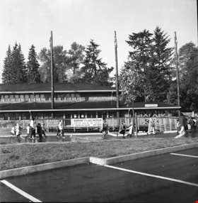
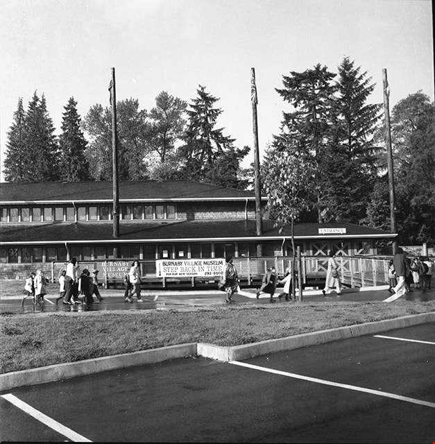
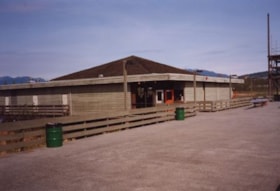
Adminstration building and entrance to Burnaby Village Museum
https://search.heritageburnaby.ca/link/museumdescription17505
- Repository
- Burnaby Village Museum
- Date
- 1990
- Collection/Fonds
- Burnaby Village Museum fonds
- Description Level
- Item
- Physical Description
- 1 photograph : b&w negative ; 6 x 6 cm
- Scope and Content
- Photograph of Burnaby Village Museum adminstration building, parking lot and entrance. A group of visitors are walking through the parking lot towards the entrance.
- Repository
- Burnaby Village Museum
- Collection/Fonds
- Burnaby Village Museum fonds
- Series
- Museum photographs series
- Description Level
- Item
- Physical Description
- 1 photograph : b&w negative ; 6 x 6 cm
- Scope and Content
- Photograph of Burnaby Village Museum adminstration building, parking lot and entrance. A group of visitors are walking through the parking lot towards the entrance.
- Subjects
- Buildings - Civic - Museums
- Names
- Burnaby Village Museum
- Geographic Access
- Deer Lake Avenue
- Street Address
- 6501 Deer Lake Avenue
- Accession Code
- BV019.2.66
- Access Restriction
- No restrictions
- Reproduction Restriction
- No known restrictions
- Date
- 1990
- Media Type
- Photograph
- Historic Neighbourhood
- Burnaby Lake (Historic Neighbourhood)
- Scan Resolution
- 1200
- Scan Date
- 2021-09-29
- Photographer
- Stevens, Colin
- Notes
- Title based on contents of photograph
- Photograph from negative roll "P90-19"
Images
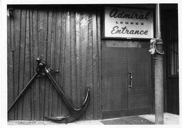
Admiral Hotel (Entrance)
https://search.heritageburnaby.ca/link/archivedescription93661
- Repository
- City of Burnaby Archives
- Date
- November 13, 1977
- Collection/Fonds
- Burnaby Public Library Contemporary Visual Archive Project
- Description Level
- Item
- Physical Description
- 1 photograph : b&w ; 12.5 x 17.5 cm
- Scope and Content
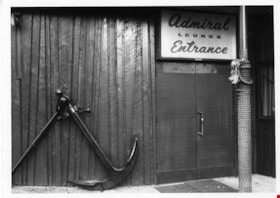
- Photograph of the entrance to the Admiral Lounge at the Admiral Hotel on Hastings Street. The photograph is taken at a close distance, facing north. The photograph shows the Lounge's sign and nautical decor.
- Repository
- City of Burnaby Archives
- Date
- November 13, 1977
- Collection/Fonds
- Burnaby Public Library Contemporary Visual Archive Project
- Physical Description
- 1 photograph : b&w ; 12.5 x 17.5 cm
- Description Level
- Item
- Record No.
- 556-618
- Access Restriction
- No restrictions
- Reproduction Restriction
- Reproduce for fair dealing purposes only
- Accession Number
- 2017-57
- Scope and Content
- Photograph of the entrance to the Admiral Lounge at the Admiral Hotel on Hastings Street. The photograph is taken at a close distance, facing north. The photograph shows the Lounge's sign and nautical decor.
- Names
- Admiral Hotel
- Media Type
- Photograph
- Photographer
- Chapman, Fred
- Notes
- Title taken from project information form
- Accompanied by a project information form and 1 photograph (b&w negative ; 9.5 x 12.5 cm)
- BPL no. 68
- Geographic Access
- Hastings Street
- Street Address
- 4125 Hastings Street
- Historic Neighbourhood
- Vancouver Heights (Historic Neighbourhood)
- Planning Study Area
- Burnaby Heights Area
Images
![Back gate entrance to east wing kitchen of Oakalla, [198-] thumbnail](/media/hpo/_Data/_BVM_Images/1991/1991_0045_0275_001.jpg?width=280)
Back gate entrance to east wing kitchen of Oakalla
https://search.heritageburnaby.ca/link/museumdescription1116
- Repository
- Burnaby Village Museum
- Date
- [198-]
- Collection/Fonds
- Oakalla Prison collection
- Description Level
- Item
- Physical Description
- 1 photgraph : b&w ; 12.5 x 13 cm
- Scope and Content
- Photograph of back gate entrance to east wing kitchen of Oakalla Prison. A tall chain link gate stands at the entrance in front of a one storey brick building.
- Repository
- Burnaby Village Museum
- Collection/Fonds
- Oakalla Prison collection
- Description Level
- Item
- Physical Description
- 1 photgraph : b&w ; 12.5 x 13 cm
- Scope and Content
- Photograph of back gate entrance to east wing kitchen of Oakalla Prison. A tall chain link gate stands at the entrance in front of a one storey brick building.
- History
- Salvaged from Oakalla Prison Farm site in October 1991
- Subjects
- Public Services - Correctional
- Geographic Access
- Oakmount Crescent
- Street Address
- 5220 Oakmount Crescent
- Accession Code
- BV991.45.275
- Access Restriction
- No restrictions
- Reproduction Restriction
- May be restricted by third party rights
- Date
- [198-]
- Media Type
- Photograph
- Historic Neighbourhood
- Burnaby Lake (Historic Neighbourhood)
- Planning Study Area
- Oakalla Area
- Scan Resolution
- 600
- Scan Date
- June 7, 2021
- Scale
- 100
- Notes
- Title based on contents of photograph
- Note in blue ink on verso of photograph reads: "BACK GATE ENTRANCE / TO EAST WING KITCHEN"
- Photograph was stapled to sheet of white looseleaf paper, three holes on left side and removed
Images
![Back gate entrance to east wing kitchen of Oakalla, [198-] thumbnail](/media/hpo/_Data/_BVM_Images/1991/1991_0045_0275_001.jpg)
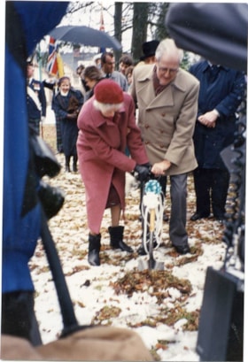
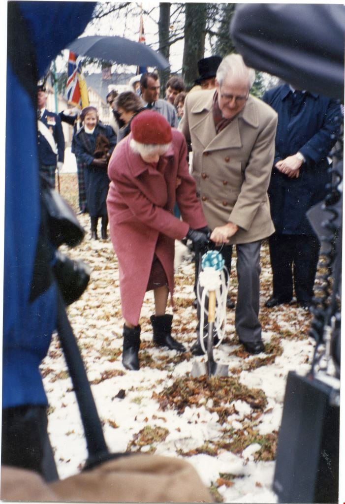
Breaking ground for the Administration/Entrance Building of the Burnaby Village Museum
https://search.heritageburnaby.ca/link/museumdescription4821
- Repository
- Burnaby Village Museum
- Date
- February 18, 1989
- Collection/Fonds
- Burnaby Village Museum Photograph collection
- Description Level
- Item
- Physical Description
- 1 photograph : color ; copy print ; 9 cm x 13 cm
- Scope and Content
- Photograph of Florence Godwin (nee Hart) and her brother at sod turning for the new BVM adminstration buiilding, 1989.
- Repository
- Burnaby Village Museum
- Collection/Fonds
- Burnaby Village Museum Photograph collection
- Description Level
- Item
- Physical Description
- 1 photograph : color ; copy print ; 9 cm x 13 cm
- Material Details
- inscribed on reserve in pen: "Florence Godwin (nee Hart) + ____ Hart (brother). / "Sod turning for new BVM Admin Building"
- Scope and Content
- Photograph of Florence Godwin (nee Hart) and her brother at sod turning for the new BVM adminstration buiilding, 1989.
- Other Title Information
- title based on content of photograph
- Accession Code
- BV018.21.1
- Access Restriction
- No restrictions
- Date
- February 18, 1989
- Media Type
- Photograph
- Scan Resolution
- 600
- Scan Date
- 03-Apr-18
Images

Burnaby hospital closes main entrance
https://search.heritageburnaby.ca/link/archivedescription95094
- Repository
- City of Burnaby Archives
- Date
- April 6, 2020
- Collection/Fonds
- Burnaby Photographic Society fonds
- Description Level
- Item
- Physical Description
- 1 photograph (tiff)
- Scope and Content
- Photograph of a rerouting sign posted to a sandwich board outside the Burnaby Hospital emergency lot. The sign states that the hospital entrance is closed and requests visitors use the Main Entrance of the hospital.
- Repository
- City of Burnaby Archives
- Date
- April 6, 2020
- Collection/Fonds
- Burnaby Photographic Society fonds
- Physical Description
- 1 photograph (tiff)
- Description Level
- Item
- Record No.
- 623-013
- Access Restriction
- No restrictions
- Reproduction Restriction
- No restrictions
- Accession Number
- 2020-10
- Scope and Content
- Photograph of a rerouting sign posted to a sandwich board outside the Burnaby Hospital emergency lot. The sign states that the hospital entrance is closed and requests visitors use the Main Entrance of the hospital.
- Subjects
- Buildings - Civic - Hospitals
- Geographic Features - Automobile Parking Lots
- Advertising Medium - Signs and Signboards
- Media Type
- Photograph
- Photographer
- Damer, Eric
- Notes
- Transcribed title
- Geographic Access
- Kincaid Street
- Street Address
- 3935 Kincaid Street
- Historic Neighbourhood
- Broadview (Historic Neighbourhood)
- Planning Study Area
- Cascade-Schou Area
Images

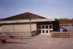
![Burnaby Lake Pavilion entrance, [1972] thumbnail](/media/hpo/_Data/_Archives_Images/_Unrestricted/371/389-003.jpg?width=280)
Burnaby Lake Pavilion entrance
https://search.heritageburnaby.ca/link/archivedescription39790
- Repository
- City of Burnaby Archives
- Date
- [1972]
- Collection/Fonds
- Burnaby Historical Society fonds
- Description Level
- Item
- Physical Description
- 1 photograph : b&w ; 8.7 x 13.3 cm
- Scope and Content
- Photograph of the entrance to the Burnaby Lake Rowing Pavilion. The pavilion and other facilities at Burnaby Lake were built in the early 1970s in preparation for the 1973 Canada Summer Games which were co-hosted in 1973 by Burnaby and New Westminster.
- Repository
- City of Burnaby Archives
- Date
- [1972]
- Collection/Fonds
- Burnaby Historical Society fonds
- Subseries
- Photographs subseries
- Physical Description
- 1 photograph : b&w ; 8.7 x 13.3 cm
- Description Level
- Item
- Record No.
- 389-003
- Access Restriction
- No restrictions
- Reproduction Restriction
- Reproduce for fair dealing purposes only
- Accession Number
- BHS2007-04
- Scope and Content
- Photograph of the entrance to the Burnaby Lake Rowing Pavilion. The pavilion and other facilities at Burnaby Lake were built in the early 1970s in preparation for the 1973 Canada Summer Games which were co-hosted in 1973 by Burnaby and New Westminster.
- Subjects
- Buildings - Recreational
- Media Type
- Photograph
- Notes
- Title based on contents of photograph.
- Geographic Access
- Burnaby Lake
- Roberts Street
- Street Address
- 6871 Roberts Street
- Historic Neighbourhood
- Burnaby Lake (Historic Neighbourhood)
- Planning Study Area
- Burnaby Lake Area
Images
![Burnaby Lake Pavilion entrance, [1972] thumbnail](/media/hpo/_Data/_Archives_Images/_Unrestricted/371/389-003.jpg)
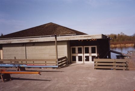
Burnaby Lake Rowing Pavilion entrance
https://search.heritageburnaby.ca/link/archivedescription36590
- Repository
- City of Burnaby Archives
- Date
- April 1992
- Collection/Fonds
- Burnaby Historical Society fonds
- Description Level
- Item
- Physical Description
- 1 photograph : col. ; 10 x 15 cm
- Scope and Content
- Photograph of the entrance to the Burnaby Lake Rowing Pavilion. The pavilion and other facilities at Burnaby Lake were built in the early 1970's in preparation for the 1973 Canada Summer Games which were co-hosted in 1973 by Burnaby and New Westminster.
- Repository
- City of Burnaby Archives
- Date
- April 1992
- Collection/Fonds
- Burnaby Historical Society fonds
- Subseries
- Nancy Peter subseries
- Physical Description
- 1 photograph : col. ; 10 x 15 cm
- Description Level
- Item
- Record No.
- 304-001
- Access Restriction
- No restrictions
- Reproduction Restriction
- Reproduce for fair dealing purposes only
- Accession Number
- BHS1992-45
- Scope and Content
- Photograph of the entrance to the Burnaby Lake Rowing Pavilion. The pavilion and other facilities at Burnaby Lake were built in the early 1970's in preparation for the 1973 Canada Summer Games which were co-hosted in 1973 by Burnaby and New Westminster.
- Subjects
- Buildings - Recreational
- Media Type
- Photograph
- Notes
- Title based on contents of photograph
- Geographic Access
- Burnaby Lake
- Roberts Street
- Street Address
- 6871 Roberts Street
- Historic Neighbourhood
- Burnaby Lake (Historic Neighbourhood)
- Planning Study Area
- Burnaby Lake Area
Images

Burnaby Lake Rowing Pavilion second entrance
https://search.heritageburnaby.ca/link/archivedescription36591
- Repository
- City of Burnaby Archives
- Date
- April 1992
- Collection/Fonds
- Burnaby Historical Society fonds
- Description Level
- Item
- Physical Description
- 1 photograph : col. ; 10 x 15 cm
- Scope and Content
- Photograph of the second entrance to the Burnaby Lake Rowing Pavilion. The pavilion and other facilities at Burnaby Lake were built in the early 1970's in preparation for the 1973 Canada Summer Games which were co-hosted in 1973 by Burnaby and New Westminster.
- Repository
- City of Burnaby Archives
- Date
- April 1992
- Collection/Fonds
- Burnaby Historical Society fonds
- Subseries
- Nancy Peter subseries
- Physical Description
- 1 photograph : col. ; 10 x 15 cm
- Description Level
- Item
- Record No.
- 304-002
- Access Restriction
- No restrictions
- Reproduction Restriction
- Reproduce for fair dealing purposes only
- Accession Number
- BHS1992-45
- Scope and Content
- Photograph of the second entrance to the Burnaby Lake Rowing Pavilion. The pavilion and other facilities at Burnaby Lake were built in the early 1970's in preparation for the 1973 Canada Summer Games which were co-hosted in 1973 by Burnaby and New Westminster.
- Subjects
- Buildings - Recreational
- Media Type
- Photograph
- Notes
- Title based on contents of photograph
- Geographic Access
- Burnaby Lake
- Roberts Street
- Street Address
- 6871 Roberts Street
- Historic Neighbourhood
- Burnaby Lake (Historic Neighbourhood)
- Planning Study Area
- Burnaby Lake Area
Images

Central Park Entrance
https://search.heritageburnaby.ca/link/archivedescription34860
- Repository
- City of Burnaby Archives
- Date
- March 23, 1985
- Collection/Fonds
- Burnaby Historical Society fonds
- Description Level
- Item
- Physical Description
- 1 photograph : col. ; 8.8 x 11.3 cm
- Scope and Content
- Photograph of the Central Park entrance on Kingsway. A car can be seen exiting the park, and the tracks of the Skytrain Expo line are in the background.
- Repository
- City of Burnaby Archives
- Date
- March 23, 1985
- Collection/Fonds
- Burnaby Historical Society fonds
- Subseries
- Evelyn Salisbury subseries
- Physical Description
- 1 photograph : col. ; 8.8 x 11.3 cm
- Description Level
- Item
- Record No.
- 145-008
- Access Restriction
- No restrictions
- Reproduction Restriction
- Reproduce for fair dealing purposes only
- Accession Number
- BHS1985-15
- Scope and Content
- Photograph of the Central Park entrance on Kingsway. A car can be seen exiting the park, and the tracks of the Skytrain Expo line are in the background.
- Subjects
- Structures - Arches
- Media Type
- Photograph
- Notes
- Title based on contents of photograph
- Geographic Access
- Central Park
- Imperial Street
- Street Address
- 3883 Imperial Street
- Historic Neighbourhood
- Central Park (Historic Neighbourhood)
- Planning Study Area
- Maywood Area
Images


Central Park Entrance
https://search.heritageburnaby.ca/link/archivedescription34861
- Repository
- City of Burnaby Archives
- Date
- March 23, 1985
- Collection/Fonds
- Burnaby Historical Society fonds
- Description Level
- Item
- Physical Description
- 1 photograph : col. ; 8.8 x 11.3 cm
- Scope and Content
- Photograph of the Central Park entrance on Kingsway. The tracks of the Skytrain Expo line can be seen in the background.
- Repository
- City of Burnaby Archives
- Date
- March 23, 1985
- Collection/Fonds
- Burnaby Historical Society fonds
- Subseries
- Evelyn Salisbury subseries
- Physical Description
- 1 photograph : col. ; 8.8 x 11.3 cm
- Description Level
- Item
- Record No.
- 145-009
- Access Restriction
- No restrictions
- Reproduction Restriction
- Reproduce for fair dealing purposes only
- Accession Number
- BHS1985-15
- Scope and Content
- Photograph of the Central Park entrance on Kingsway. The tracks of the Skytrain Expo line can be seen in the background.
- Subjects
- Structures - Arches
- Media Type
- Photograph
- Notes
- Title based on contents of photograph
- Geographic Access
- Central Park
- Imperial Street
- Street Address
- 3883 Imperial Street
- Historic Neighbourhood
- Central Park (Historic Neighbourhood)
- Planning Study Area
- Maywood Area
Images


Central Park Entrance
https://search.heritageburnaby.ca/link/archivedescription38507
- Repository
- City of Burnaby Archives
- Date
- 1914
- Collection/Fonds
- Burnaby Historical Society fonds
- Description Level
- Item
- Physical Description
- 1 photograph : b&w postcard ; 9 x 14 cm
- Scope and Content
- Photographic postcard of the entrance arch at Central Park. The postcard was sent to R.M. Harding of Everett, Washington and bears a New Westminster postmark and is dated August 6, 1922. The note written on the reverse of the card reads: " Dear Ross, This is were [sic] we made camp tonight. Wish…
- Repository
- City of Burnaby Archives
- Date
- 1914
- Collection/Fonds
- Burnaby Historical Society fonds
- Subseries
- Photographs subseries
- Physical Description
- 1 photograph : b&w postcard ; 9 x 14 cm
- Description Level
- Item
- Record No.
- 449-002
- Access Restriction
- No restrictions
- Reproduction Restriction
- No known restrictions
- Accession Number
- BHS2007-04
- Scope and Content
- Photographic postcard of the entrance arch at Central Park. The postcard was sent to R.M. Harding of Everett, Washington and bears a New Westminster postmark and is dated August 6, 1922. The note written on the reverse of the card reads: " Dear Ross, This is were [sic] we made camp tonight. Wish you were with us. We have had a dandy trip so far - but awfully dusty for about 14 miles from this side of the border line. Love, Eva."
- Names
- Harding, Ross M.
- Media Type
- Photograph
- Notes
- Title based on contents of photograph.
- Geographic Access
- Central Park
- Imperial Street
- Street Address
- 3883 Imperial Street
- Historic Neighbourhood
- Central Park (Historic Neighbourhood)
- Planning Study Area
- Maywood Area
Images

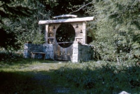
Chapel entrance - Wilson Creek
https://search.heritageburnaby.ca/link/museumdescription5073
- Repository
- Burnaby Village Museum
- Date
- May 1965
- Collection/Fonds
- Burnaby Girl Guides fonds
- Description Level
- Item
- Physical Description
- 1 photograph : col. slide ; 35 mm
- Scope and Content
- Photograph of the Chapel entrance of the Burnaby Girl Guide camp at Wilson Creek. The chapel entrance is a stone walled structure with a decorative wooden gate and circular portico surrounded by trees and foliage.
- Repository
- Burnaby Village Museum
- Collection/Fonds
- Burnaby Girl Guides fonds
- Description Level
- Item
- Physical Description
- 1 photograph : col. slide ; 35 mm
- Scope and Content
- Photograph of the Chapel entrance of the Burnaby Girl Guide camp at Wilson Creek. The chapel entrance is a stone walled structure with a decorative wooden gate and circular portico surrounded by trees and foliage.
- Names
- Girl Guides of Canada
- Accession Code
- BV015.36.112
- Access Restriction
- No restrictions
- Reproduction Restriction
- May be restricted by third party rights
- Date
- May 1965
- Media Type
- Photograph
- Arrangement
- Loose photographs and slides arranged by Kathryn Raadsheer nee Hardy.
- Notes
- Title based on content of photograph
- Note in blue ink on verso of slides reads: "Chapel entrance Wilson / Creek May 65"
Images


Detail of tin ceiling in entrance hallway
https://search.heritageburnaby.ca/link/museumdescription9978
- Repository
- Burnaby Village Museum
- Date
- 1988
- Collection/Fonds
- Burnaby Village Museum fonds
- Description Level
- Item
- Physical Description
- 1 photograph : b&w negative ; 35 mm
- Scope and Content
- Photograph detail of the painted tin ceiling in the entrance hallway of the Love farmhouse. The photograph was taken while the house was still located at 7651 Cumberland Street before being moved to the Burnaby Village Museum in May 1988. The original tin ceiling was restored and painted on the sit…
- Repository
- Burnaby Village Museum
- Collection/Fonds
- Burnaby Village Museum fonds
- Series
- Jesse Love farmhouse series
- Description Level
- Item
- Physical Description
- 1 photograph : b&w negative ; 35 mm
- Scope and Content
- Photograph detail of the painted tin ceiling in the entrance hallway of the Love farmhouse. The photograph was taken while the house was still located at 7651 Cumberland Street before being moved to the Burnaby Village Museum in May 1988. The original tin ceiling was restored and painted on the site of the Burnaby Village Museum.
- Subjects
- Buildings - Heritage
- Geographic Access
- Cumberland Street
- Street Address
- 7651 Cumberland Street
- Accession Code
- BV018.41.165
- Access Restriction
- No restrictions
- Reproduction Restriction
- May be restricted by third party rights
- Date
- 1988
- Media Type
- Photograph
- Historic Neighbourhood
- East Burnaby (Historic Neighbourhood)
- Planning Study Area
- Cariboo-Armstrong Area
- Scan Resolution
- 1000
- Scan Date
- 31-Jan-2019
- Scale
- 100
- Notes
- Title based on contents of photograph
- Photograph is one of a group of 25 photographs that were taken by Jim Wolf (not all photographs were described)
- See BV988.33.34 for description of artifact
Images


Employees' Entrance
https://search.heritageburnaby.ca/link/archivedescription79403
- Repository
- City of Burnaby Archives
- Date
- October 1976
- Collection/Fonds
- Burnaby Public Library Contemporary Visual Archive Project
- Description Level
- Item
- Physical Description
- 1 photograph : b&w ; 11 x 16 cm mounted on cardboard
- Scope and Content
- Photograph shows the employees' entrance to the Dominion Bridge building on Boundary Road.
- Repository
- City of Burnaby Archives
- Date
- October 1976
- Collection/Fonds
- Burnaby Public Library Contemporary Visual Archive Project
- Physical Description
- 1 photograph : b&w ; 11 x 16 cm mounted on cardboard
- Description Level
- Item
- Record No.
- 556-278
- Access Restriction
- No restrictions
- Reproduction Restriction
- Reproduce for fair dealing purposes only
- Accession Number
- 2013-13
- Scope and Content
- Photograph shows the employees' entrance to the Dominion Bridge building on Boundary Road.
- Media Type
- Photograph
- Photographer
- Cook, Alan
- Notes
- Scope note taken directly from BPL photograph description.
- 1 b&w copy negative : 10 x 12.5 cm accompanying
- Geographic Access
- Henning Drive
- Street Address
- 3880 Henning Drive
- Historic Neighbourhood
- Broadview (Historic Neighbourhood)
- Planning Study Area
- West Central Valley Area
Images
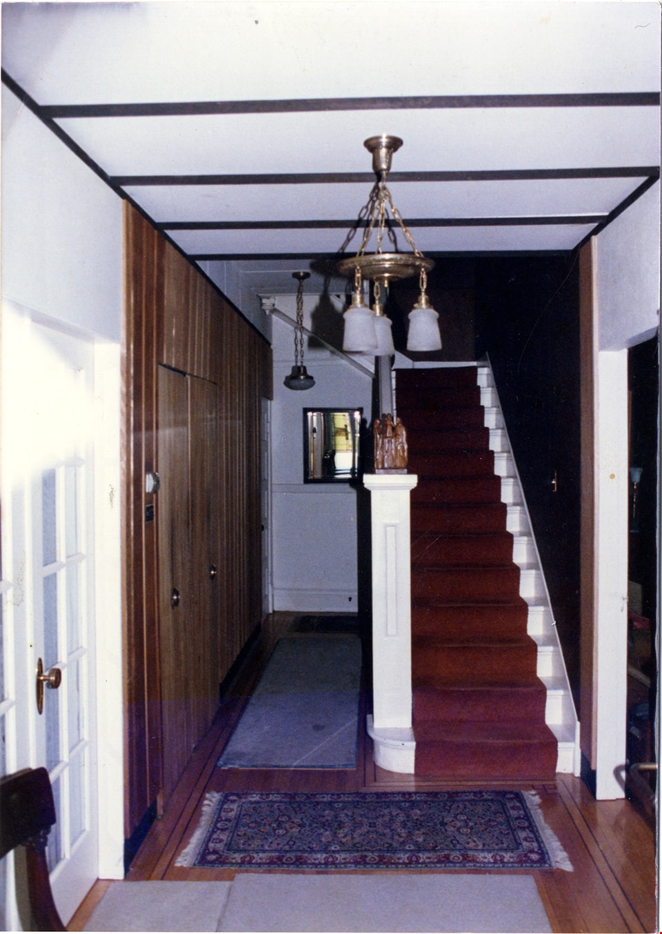
Entrance hall and stairway inside Mawhinney house
https://search.heritageburnaby.ca/link/museumdescription15574
- Repository
- Burnaby Village Museum
- Date
- 1962
- Collection/Fonds
- Reverend Edward S. Gale fonds
- Description Level
- Item
- Physical Description
- 1 photograph : col. ; 17.5 x 12.5 cm
- Scope and Content
- Photograph of the front entrance hall and stairway inside of the Mervin Mawhinney house. The address of the house was 7661 Burris Street and was changed to 7667 Burris Street in 1984.
- Repository
- Burnaby Village Museum
- Collection/Fonds
- Reverend Edward S. Gale fonds
- Description Level
- Item
- Physical Description
- 1 photograph : col. ; 17.5 x 12.5 cm
- Scope and Content
- Photograph of the front entrance hall and stairway inside of the Mervin Mawhinney house. The address of the house was 7661 Burris Street and was changed to 7667 Burris Street in 1984.
- Geographic Access
- Burris Street
- Street Address
- 7667 Burris Street
- Accession Code
- BV018.9.39
- Access Restriction
- No restrictions
- Reproduction Restriction
- May be restricted by third party rights
- Date
- 1962
- Media Type
- Photograph
- Planning Study Area
- Morley-Buckingham Area
- Scan Resolution
- 600
- Scan Date
- April 15, 2021
- Scale
- 100
- Photographer
- Weller, Michael
- Notes
- Title based on contents of photograph
Images

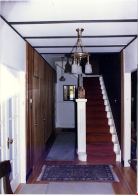
Entrance hall and stairway inside Mawhinney house
https://search.heritageburnaby.ca/link/museumdescription15575
- Repository
- Burnaby Village Museum
- Date
- 1987
- Collection/Fonds
- Reverend Edward S. Gale fonds
- Description Level
- Item
- Physical Description
- 1 photograph : col. ; 12.5 x 9 cm
- Scope and Content
- Photograph of the front entrance hall and stairway inside of the Mervin Mawhinney house located at 7667 Burris Street in Burnaby. Photograph was taken after renovations by Reverend Gale whereby the wood panelling and dropped ceiling were added. Two lighting fixtures are hanging from the ceiling and…
- Repository
- Burnaby Village Museum
- Collection/Fonds
- Reverend Edward S. Gale fonds
- Description Level
- Item
- Physical Description
- 1 photograph : col. ; 12.5 x 9 cm
- Scope and Content
- Photograph of the front entrance hall and stairway inside of the Mervin Mawhinney house located at 7667 Burris Street in Burnaby. Photograph was taken after renovations by Reverend Gale whereby the wood panelling and dropped ceiling were added. Two lighting fixtures are hanging from the ceiling and an oriental style carpet sits at the base of the staircase. Two french doors are visible on the left and a mirror is hanging on the wall at the end of the hallway next to the stairwell.
- Geographic Access
- Burris Street
- Street Address
- 7667 Burris Street
- Accession Code
- BV018.9.40
- Access Restriction
- No restrictions
- Reproduction Restriction
- May be restricted by third party rights
- Date
- 1987
- Media Type
- Photograph
- Planning Study Area
- Morley-Buckingham Area
- Scan Resolution
- 600
- Scan Date
- April 20, 2021
- Scale
- 100
- Notes
- Title based on contents of photograph
Images
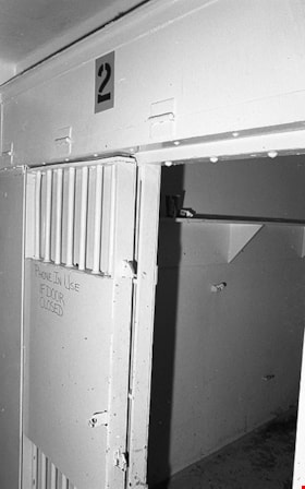
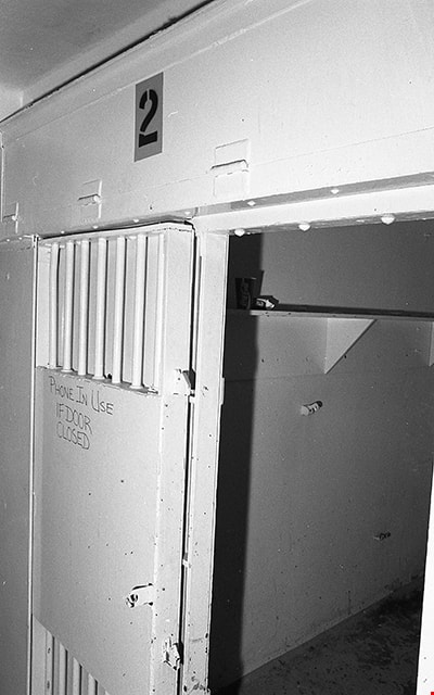
Entrance to death row cell number two
https://search.heritageburnaby.ca/link/museumdescription17935
- Repository
- Burnaby Village Museum
- Date
- 1991
- Collection/Fonds
- Oakalla Prison collection
- Description Level
- Item
- Physical Description
- 1 photograph : col. negative ; 35 mm
- Scope and Content
- Photograph of entrance into death row cell number two inside Oakalla Prison (Lower Mainland Regional Correctional Centre). Cell door is open and interior with shelf is visible. Signage above cell door reads "2" and hand written signage on cell door reads "PHONE IN USE / IF DOOR / CLOSED".
- Repository
- Burnaby Village Museum
- Collection/Fonds
- Oakalla Prison collection
- Description Level
- Item
- Physical Description
- 1 photograph : col. negative ; 35 mm
- Scope and Content
- Photograph of entrance into death row cell number two inside Oakalla Prison (Lower Mainland Regional Correctional Centre). Cell door is open and interior with shelf is visible. Signage above cell door reads "2" and hand written signage on cell door reads "PHONE IN USE / IF DOOR / CLOSED".
- Subjects
- Public Services - Correctional
- Geographic Access
- Oakmount Crescent
- Street Address
- 5220 Oakmount Crescent
- Accession Code
- BV991.45.719
- Access Restriction
- No restrictions
- Reproduction Restriction
- No known restrictions
- Date
- 1991
- Media Type
- Photograph
- Historic Neighbourhood
- Burnaby Lake (Historic Neighbourhood)
- Planning Study Area
- Oakalla Area
- Scan Resolution
- 2400
- Scan Date
- 2021-08-24
- Photographer
- Stevens, Colin
- Notes
- Title based on contents of photograph
- Photograph negative #22 from Roll 91-22
- 1 b&w copy print accompanying
- Note in black ink on verso of accompanying copy print photograph reads:"P91-[20]-22-22" ("20 is crossed out and replaced with "22")
Images
![Entrance to Listening Sap, [between 1914 and 1918] thumbnail](/media/hpo/_Data/_Archives_Images/_Unrestricted/550/550-124.jpg?width=280)
Entrance to Listening Sap
https://search.heritageburnaby.ca/link/archivedescription82553
- Repository
- City of Burnaby Archives
- Date
- [between 1914 and 1918]
- Collection/Fonds
- Hill family and Vidal family fonds
- Description Level
- Item
- Physical Description
- 1 photograph : sepia ; 6 x 4 cm
- Scope and Content
- Photograph is a portrait of five soldiers sitting in a trench.
- Repository
- City of Burnaby Archives
- Date
- [between 1914 and 1918]
- Collection/Fonds
- Hill family and Vidal family fonds
- Physical Description
- 1 photograph : sepia ; 6 x 4 cm
- Description Level
- Item
- Record No.
- 550-124
- Access Restriction
- No restrictions
- Reproduction Restriction
- No known restrictions
- Accession Number
- 2013-03
- Scope and Content
- Photograph is a portrait of five soldiers sitting in a trench.
- Media Type
- Photograph
- Notes
- Title based on note accompanying photograph
- Note in black pen on verso reads: "Entrance to Listening Sap / M & N"
Images
![Entrance to Listening Sap, [between 1914 and 1918] thumbnail](/media/hpo/_Data/_Archives_Images/_Unrestricted/550/550-124.jpg)

Entrance to New Haven
https://search.heritageburnaby.ca/link/museumdescription13532
- Repository
- Burnaby Village Museum
- Date
- Jan. 2001
- Collection/Fonds
- Burnaby Village Museum Photograph collection
- Description Level
- Item
- Physical Description
- 1 photograph : col. ; 5.3 x 10 cm
- Scope and Content
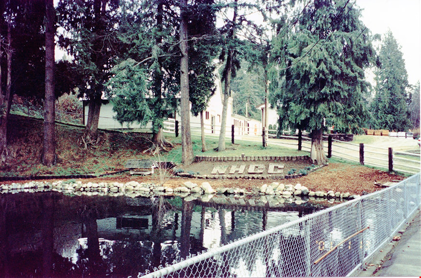
- Photograph of roadway entrance to New Haven Correctional Centre with the intitals "NHCC" located in a garden along the bank of a pond. Farm buildings are visible behind the trees.
- Repository
- Burnaby Village Museum
- Collection/Fonds
- Burnaby Village Museum Photograph collection
- Description Level
- Item
- Physical Description
- 1 photograph : col. ; 5.3 x 10 cm
- Scope and Content
- Photograph of roadway entrance to New Haven Correctional Centre with the intitals "NHCC" located in a garden along the bank of a pond. Farm buildings are visible behind the trees.
- History
- In 1937 New Haven Correctional Centre was established as the British Columbia Training School on the southeast side of Marine Drive in Burnaby (4250 Marine Drive). Sections of Sussex and Patterson Avenues bordered the estate. Originally, the facility housed nineteen inmates with two staff and was one of the first initiatives in Canada to segregate young adult inmates into a separate institution apart from adults. This was part of the Borstal system that started in England whereby young male offenders between the ages of sixteen and twenty one were trained to earn an honest living. Alterations and additions to the estate took place between December 1937 and October 1939 so that more inmates could be accomodated. Five new cottages were built that could hold up to forty people. Except for the plastering and lighting, all work on the new cottages was done by the inmates. On October 29, 1939, the Lieutenant-Governor Eric Hamber formally opened the New Haven Borstal School. World War II interrupted full development of the intstitution and it was closed in 1941 when the inmates were were conscripted into the army. Between 1941 and 1947 the Deaf and Blind Institute were housed at New Haven. In 1947, the New Haven Borstal School returned to the estate. New additions were added to old buildings and new additional buildings were erected on the site over the years including a warden's house on the east grounds and a barn and gymnasium. In the 1970s an equipment shed was added along with another dormitory and a variety of small sheds and storage buildings. The correctional centre officially closed in March 2001.
- Subjects
- Public Services - Correctional
- Geographic Access
- Marine Drive
- Street Address
- 4250 Marine Drive
- Accession Code
- BV020.5.876
- Access Restriction
- No restrictions
- Reproduction Restriction
- No known restrictions
- Date
- Jan. 2001
- Media Type
- Photograph
- Historic Neighbourhood
- Fraser Arm (Historic Neighbourhood)
- Planning Study Area
- Suncrest Area
- Scan Resolution
- 600
- Scan Date
- 25-Aug-2020
- Scale
- 100
- Notes
- Title based on contents of photograph
- Photograph processing stamp on front of photograph reads: "'01_1_13"
- Historical information based on notes from Mary Forsyth's research notes "New Haven" MSS185-018
Images