Narrow Results By
Subject
- Accidents - Automobile Accidents 1
- Advertising Medium - Signs and Signboards 2
- Aerial Photographs 2
- Agricultural Tools and Equipment 3
- Agriculture - Crops 6
- Agriculture - Farms 7
- Agriculture - Fruit and Berries 3
- Animals - Cows 2
- Animals - Dogs 2
- Animals - Horses 6
- Buildings - Agricultural 16
- Buildings - Commercial 3
1160 Douglas Rd
https://search.heritageburnaby.ca/link/archivedescription94327
- Repository
- City of Burnaby Archives
- Date
- December 1994
- Collection/Fonds
- Grover, Elliott & Co. Ltd. fonds
- Description Level
- File
- Physical Description
- 22 photographs : col. negatives ; 35 mm
- Scope and Content
- Photographs of the exterior of a three-storey commerical building located at 1160 Douglas Road.
- Repository
- City of Burnaby Archives
- Date
- December 1994
- Collection/Fonds
- Grover, Elliott & Co. Ltd. fonds
- Physical Description
- 22 photographs : col. negatives ; 35 mm
- Description Level
- File
- Record No.
- 622-112
- Access Restriction
- No restrictions
- Reproduction Restriction
- No restrictions
- Accession Number
- 2017-39
- Scope and Content
- Photographs of the exterior of a three-storey commerical building located at 1160 Douglas Road.
- Media Type
- Photograph
- Photographer
- Young, Richard
- Notes
- Transcribed title
- Title transcribed from envelope photographs were originally housed in
- File no. 94-424-B
- Geographic Access
- Douglas Road
- Street Address
- 1160 Douglas Road
- Historic Neighbourhood
- Vancouver Heights (Historic Neighbourhood)
- Planning Study Area
- Willingdon Heights Area
5499-5495 Regent Street / 2857 Douglas Road
https://search.heritageburnaby.ca/link/archivedescription93713
- Repository
- City of Burnaby Archives
- Date
- 1987
- Collection/Fonds
- Grover, Elliott & Co. Ltd. fonds
- Description Level
- File
- Physical Description
- 24 photographs : col. negatives ; 35 mm
- Scope and Content
- Photographs of the building exterior and loading bays of Loomis, located at 5499 and 5495 Regent Street, and of 2857 Douglas Road. 5499 and 5495 Regent Street are addresses that no longer exist; the current address is 5491 Regent Street.
- Repository
- City of Burnaby Archives
- Date
- 1987
- Collection/Fonds
- Grover, Elliott & Co. Ltd. fonds
- Physical Description
- 24 photographs : col. negatives ; 35 mm
- Description Level
- File
- Record No.
- 622-002
- Access Restriction
- No restrictions
- Reproduction Restriction
- No restrictions
- Accession Number
- 2017-39
- Scope and Content
- Photographs of the building exterior and loading bays of Loomis, located at 5499 and 5495 Regent Street, and of 2857 Douglas Road. 5499 and 5495 Regent Street are addresses that no longer exist; the current address is 5491 Regent Street.
- Media Type
- Photograph
- Notes
- Transcribed title
- Title transcribed from original print envelope
- File no. 87-133-B
- Geographic Access
- Douglas Road
- Regent Street
- Street Address
- 2857 Douglas Road
- 5491 Regent Street
- Historic Neighbourhood
- Burnaby Lake (Historic Neighbourhood)
- Planning Study Area
- Dawson-Delta Area
7818 6th Street
https://search.heritageburnaby.ca/link/archivedescription93731
- Repository
- City of Burnaby Archives
- Date
- 1989
- Collection/Fonds
- Grover, Elliott & Co. Ltd. fonds
- Description Level
- File
- Physical Description
- 26 photographs : col. negatives ; 35 mm
- Scope and Content
- Photographs of the exterior of a Benjamin Moore Paints store and surrounding area. The store is located on a corner opposite Microtel and outside the store, a sign for the Skytrain Operations and Maintenance Centre is visible.
- Repository
- City of Burnaby Archives
- Date
- 1989
- Collection/Fonds
- Grover, Elliott & Co. Ltd. fonds
- Physical Description
- 26 photographs : col. negatives ; 35 mm
- Description Level
- File
- Record No.
- 622-019
- Access Restriction
- No restrictions
- Reproduction Restriction
- No restrictions
- Accession Number
- 2017-39
- Scope and Content
- Photographs of the exterior of a Benjamin Moore Paints store and surrounding area. The store is located on a corner opposite Microtel and outside the store, a sign for the Skytrain Operations and Maintenance Centre is visible.
- Media Type
- Photograph
- Notes
- Transcribed title
- Title transcribed from original print envelope
- File no. 89v-004-O
- Property address could not be confirmed at time of description.
- Geographic Access
- 6th Street
- 12th Avenue
- Street Address
- 7818 6th Street
- Historic Neighbourhood
- East Burnaby (Historic Neighbourhood)
- Planning Study Area
- Second Street Area
![Aerial photograph of Douglas Road and Sperling Avenue, [1938] thumbnail](/media/hpo/_Data/_BVM_Images/1990/199200470001.jpg?width=280)
Aerial photograph of Douglas Road and Sperling Avenue
https://search.heritageburnaby.ca/link/museumdescription1165
- Repository
- Burnaby Village Museum
- Date
- [1938]
- Collection/Fonds
- Burnaby Village Museum Photograph collection
- Description Level
- Item
- Physical Description
- 1 photograph : b&w ; 19 x 24 cm
- Scope and Content
- Aerial photograph of the area surrounding Douglas Road and Sperling Avenue.
- Repository
- Burnaby Village Museum
- Collection/Fonds
- Burnaby Village Museum Photograph collection
- Description Level
- Item
- Physical Description
- 1 photograph : b&w ; 19 x 24 cm
- Scope and Content
- Aerial photograph of the area surrounding Douglas Road and Sperling Avenue.
- Subjects
- Aerial Photographs
- Geographic Access
- Douglas Road
- Sperling Avenue
- Accession Code
- BV992.47.1
- Access Restriction
- No restrictions
- Date
- [1938]
- Media Type
- Photograph
- Historic Neighbourhood
- Burnaby Lake (Historic Neighbourhood)
- Planning Study Area
- Morley-Buckingham Area
- Scan Resolution
- 600
- Scan Date
- 01-Jun-09
- Scale
- 100
- Notes
- Title based on contents of photograph
- Notes on verso of photograph read: "Burnaby Image Bank #532" and "DOUGLAS ROAD AND SPERLING c. 1938"
- Stamp on verso of photograph reads: "Copyright Simon Fraser/ University Archives"
Images
![Aerial photograph of Douglas Road and Sperling Avenue, [1938] thumbnail](/media/hpo/_Data/_BVM_Images/1990/199200470001.jpg)
![Aerial photograph of the Burnaby Village area, [1946] (date of original), copied 1991 thumbnail](/media/hpo/_Data/_Archives_Images/_Unrestricted/370/370-532.jpg?width=280)
Aerial photograph of the Burnaby Village area
https://search.heritageburnaby.ca/link/archivedescription37945
- Repository
- City of Burnaby Archives
- Date
- [1946] (date of original), copied 1991
- Collection/Fonds
- Burnaby Historical Society fonds
- Description Level
- Item
- Physical Description
- 1 photograph : b&w ; 3.5 x 4.4 cm print on contact sheet 20.5 x 26.7 cm
- Scope and Content
- Aerial photograph of the Sperling Avenue/Douglas Road Burnaby Village area.
- Repository
- City of Burnaby Archives
- Date
- [1946] (date of original), copied 1991
- Collection/Fonds
- Burnaby Historical Society fonds
- Subseries
- Burnaby Image Bank subseries
- Physical Description
- 1 photograph : b&w ; 3.5 x 4.4 cm print on contact sheet 20.5 x 26.7 cm
- Description Level
- Item
- Record No.
- 370-532
- Access Restriction
- No restrictions
- Reproduction Restriction
- No known restrictions
- Accession Number
- BHS1999-03
- Scope and Content
- Aerial photograph of the Sperling Avenue/Douglas Road Burnaby Village area.
- Subjects
- Aerial Photographs
- Media Type
- Photograph
- Notes
- Title based on contents of photograph
- 1 b&w copy negative accompanying
- Negative has a pink cast
- Geographic Access
- Douglas Road
- Sperling Avenue
- Canada Way
- Historic Neighbourhood
- Burnaby Lake (Historic Neighbourhood)
Images
![Aerial photograph of the Burnaby Village area, [1946] (date of original), copied 1991 thumbnail](/media/hpo/_Data/_Archives_Images/_Unrestricted/370/370-532.jpg)

Back of Whitechurch Hardware building
https://search.heritageburnaby.ca/link/museumdescription16889
- Repository
- Burnaby Village Museum
- Date
- Aug. 1974
- Collection/Fonds
- Burnaby Village Museum fonds
- Description Level
- Item
- Physical Description
- 1 photograph : col. slide ; 35 mm
- Scope and Content
- Photograph of the back of the Whitechurch Hardware building during the preparation for the building to be moved from 7685 Sixth Street to Heritage Village (Burnaby Village Museum). The back of the building is supported with a temporary back for the move.
- Repository
- Burnaby Village Museum
- Collection/Fonds
- Burnaby Village Museum fonds
- Subseries
- Bell's building photographs subseries
- Description Level
- Item
- Physical Description
- 1 photograph : col. slide ; 35 mm
- Scope and Content
- Photograph of the back of the Whitechurch Hardware building during the preparation for the building to be moved from 7685 Sixth Street to Heritage Village (Burnaby Village Museum). The back of the building is supported with a temporary back for the move.
- Geographic Access
- 6th Street
- Street Address
- 7695 6th Street
- 7685 6th Street
- Accession Code
- BV020.5.1859
- Access Restriction
- No restrictions
- Reproduction Restriction
- No known restrictions
- Date
- Aug. 1974
- Media Type
- Photograph
- Historic Neighbourhood
- East Burnaby (Historic Neighbourhood)
- Planning Study Area
- Second Street Area
- Scan Resolution
- 2400
- Scale
- 100
- Notes
- Title based on contents of photograph
- Note in blue ink on slide frame reads: "(FRONT) / VIEW FROM THIS SIDE / WRONG SIDE / 1974 / Whitechurch Hardware / Temporary Back / Before move to HV"
- 1 col. copy print accompanying
Images


Back of Whitechurch Hardware building
https://search.heritageburnaby.ca/link/museumdescription16891
- Repository
- Burnaby Village Museum
- Date
- Aug. 1974
- Collection/Fonds
- Burnaby Village Museum fonds
- Description Level
- Item
- Physical Description
- 1 photograph : col. slide ; 35 mm
- Scope and Content
- Photograph of the back of the Whitechurch Hardware building during the preparation for the building to be moved by the Nickel Brothers house moving company from 7685 Sixth Street to Heritage Village (Burnaby Village Museum). Right section of back of the building is missing.
- Repository
- Burnaby Village Museum
- Collection/Fonds
- Burnaby Village Museum fonds
- Subseries
- Bell's building photographs subseries
- Description Level
- Item
- Physical Description
- 1 photograph : col. slide ; 35 mm
- Scope and Content
- Photograph of the back of the Whitechurch Hardware building during the preparation for the building to be moved by the Nickel Brothers house moving company from 7685 Sixth Street to Heritage Village (Burnaby Village Museum). Right section of back of the building is missing.
- Geographic Access
- 6th Street
- Street Address
- 7695 6th Street
- 7685 6th Street
- Accession Code
- BV020.5.1861
- Access Restriction
- No restrictions
- Reproduction Restriction
- No known restrictions
- Date
- Aug. 1974
- Media Type
- Photograph
- Historic Neighbourhood
- East Burnaby (Historic Neighbourhood)
- Planning Study Area
- Second Street Area
- Scan Resolution
- 2400
- Scale
- 100
- Notes
- Title based on contents of photograph
- Note in blue ink on slide frame reads: "Rear of Whitechurch / showing removed / back set on 6th St."
Images

![BaroMedical Hyperbaric Oxygen Clinic, [2000] thumbnail](/media/hpo/_Data/_Archives_Images/_Unrestricted/535/535-1674-2.jpg?width=280)
BaroMedical Hyperbaric Oxygen Clinic
https://search.heritageburnaby.ca/link/archivedescription95874
- Repository
- City of Burnaby Archives
- Date
- [2000]
- Collection/Fonds
- Burnaby NewsLeader photograph collection
- Description Level
- File
- Physical Description
- 2 photographs (tiff) : col.
- Scope and Content
- File contains photographs of technicians demonstrating hyperbaric chambers at BaroMedical Hyperbaric Oxygen Clinic.
- Repository
- City of Burnaby Archives
- Date
- [2000]
- Collection/Fonds
- Burnaby NewsLeader photograph collection
- Physical Description
- 2 photographs (tiff) : col.
- Description Level
- File
- Record No.
- 535-1674
- Access Restriction
- No restrictions
- Reproduction Restriction
- No restrictions
- Accession Number
- 2018-12
- Scope and Content
- File contains photographs of technicians demonstrating hyperbaric chambers at BaroMedical Hyperbaric Oxygen Clinic.
- Media Type
- Photograph
- Photographer
- Bartel, Mario
- Notes
- Title based on caption
- Collected by editorial for use in a November 2000 issue of the Burnaby NewsLeader
- Caption from metadata for 535-1674-1: "Svejtlana Ruzic, a hyperbaric technician at BaroMedical, in one of the the clinic's freestanding hyperbaric chambers."
- Caption from metadata for 535-1674-2: "Dijana Horgas and Svjetlana Ruzic, hyperbaric technicians at BaroMedical, demonstrate how technicians are able to communicate with the patient while the patient is undergoing treatment in a hyperbaric chamber."
- Geographic Access
- 6th Street
- Street Address
- 7850 6th Street
- Planning Study Area
- Second Street Area
Images
![BaroMedical Hyperbaric Oxygen Clinic, [2000] thumbnail](/media/hpo/_Data/_Archives_Images/_Unrestricted/535/535-1674-2.jpg)
![Bernard Hill farm, [190-] (date of original), copied 1986 thumbnail](/media/hpo/_Data/_Archives_Images/_Unrestricted/204/204-789.jpg?width=280)
Bernard Hill farm
https://search.heritageburnaby.ca/link/archivedescription35929
- Repository
- City of Burnaby Archives
- Date
- [190-] (date of original), copied 1986
- Collection/Fonds
- Burnaby Historical Society fonds
- Description Level
- Item
- Physical Description
- 1 photograph : b&w ; 12.7 x 17.8 cm print
- Scope and Content
- Photograph of the Hill brothers Frank, Claude and Gerry and their pet dog riding on hay wagon on their father's farm.
- Repository
- City of Burnaby Archives
- Date
- [190-] (date of original), copied 1986
- Collection/Fonds
- Burnaby Historical Society fonds
- Subseries
- Pioneer Tales subseries
- Physical Description
- 1 photograph : b&w ; 12.7 x 17.8 cm print
- Description Level
- Item
- Record No.
- 204-789
- Access Restriction
- No restrictions
- Reproduction Restriction
- No restrictions
- Accession Number
- BHS1988-03
- Scope and Content
- Photograph of the Hill brothers Frank, Claude and Gerry and their pet dog riding on hay wagon on their father's farm.
- Subjects
- Animals - Dogs
- Transportation - Horses
- Agriculture - Crops
- Agricultural Tools and Equipment
- Media Type
- Photograph
- Notes
- Title based on contents of photograph
- Geographic Access
- Douglas Road
- Canada Way
- Street Address
- 4990 Canada Way
- Historic Neighbourhood
- Burnaby Lake (Historic Neighbourhood)
- Planning Study Area
- Douglas-Gilpin Area
Images
![Bernard Hill farm, [190-] (date of original), copied 1986 thumbnail](/media/hpo/_Data/_Archives_Images/_Unrestricted/204/204-789.jpg)
![Bernard Hill's home, [1905] thumbnail](/media/hpo/_Data/_Archives_Images/_Unrestricted/477/477-863.jpg?width=280)
Bernard Hill's home
https://search.heritageburnaby.ca/link/archivedescription39544
- Repository
- City of Burnaby Archives
- Date
- [1905]
- Collection/Fonds
- Peers Family and Hill Family fonds
- Description Level
- Item
- Physical Description
- 1 photograph : b&w ; 7.5 x 10 cm on page 21.5 x 28 cm (pasted in album)
- Scope and Content
- Photograph of the house belonging to Bernard Hill in the Burnaby Lake area on what is now Canada Way. Douglas Road runs through the foreground.
- Repository
- City of Burnaby Archives
- Date
- [1905]
- Collection/Fonds
- Peers Family and Hill Family fonds
- Physical Description
- 1 photograph : b&w ; 7.5 x 10 cm on page 21.5 x 28 cm (pasted in album)
- Description Level
- Item
- Record No.
- 477-863
- Access Restriction
- No restrictions
- Reproduction Restriction
- No known restrictions
- Accession Number
- 2007-12
- Scope and Content
- Photograph of the house belonging to Bernard Hill in the Burnaby Lake area on what is now Canada Way. Douglas Road runs through the foreground.
- Subjects
- Buildings - Residential - Houses
- Media Type
- Photograph
- Notes
- Title based on caption accompanying photograph
- Geographic Access
- Douglas Road
- Canada Way
- Street Address
- 4990 Canada Way
- Historic Neighbourhood
- Burnaby Lake (Historic Neighbourhood)
- Planning Study Area
- Douglas-Gilpin Area
Images
![Bernard Hill's home, [1905] thumbnail](/media/hpo/_Data/_Archives_Images/_Unrestricted/477/477-863.jpg)
![Bert Porter on a steamroller, [1919] (date of original), copied 1985 thumbnail](/media/hpo/_Data/_Archives_Images/_Unrestricted/126/140-011.jpg?width=280)
Bert Porter on a steamroller
https://search.heritageburnaby.ca/link/archivedescription34830
- Repository
- City of Burnaby Archives
- Date
- [1919] (date of original), copied 1985
- Collection/Fonds
- Burnaby Historical Society fonds
- Description Level
- Item
- Physical Description
- 1 photograph : b&w ; 8.8 x 12.5 cm print
- Scope and Content
- Photograph of Bert Porter with a municipal steamroller on Douglas Road. He worked many years operating a steam roller for the municipality, flattening out gravel streets after grading, and was the husband of Lillie Lewis Porter.
- Repository
- City of Burnaby Archives
- Date
- [1919] (date of original), copied 1985
- Collection/Fonds
- Burnaby Historical Society fonds
- Subseries
- Lewis family subseries
- Physical Description
- 1 photograph : b&w ; 8.8 x 12.5 cm print
- Description Level
- Item
- Record No.
- 140-011
- Access Restriction
- No restrictions
- Reproduction Restriction
- No known restrictions
- Accession Number
- BHS1985-10
- Scope and Content
- Photograph of Bert Porter with a municipal steamroller on Douglas Road. He worked many years operating a steam roller for the municipality, flattening out gravel streets after grading, and was the husband of Lillie Lewis Porter.
- Subjects
- Construction Tools and Equipment
- Occupations - Labourers
- Occupations - Civic Workers
- Construction - Road Construction
- Names
- Porter, Bert
- Media Type
- Photograph
- Notes
- Title based on contents of photograph
- Geographic Access
- Douglas Road
Images
![Bert Porter on a steamroller, [1919] (date of original), copied 1985 thumbnail](/media/hpo/_Data/_Archives_Images/_Unrestricted/126/140-011.jpg)
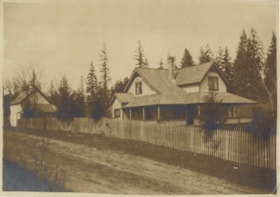
B. R. Hill home
https://search.heritageburnaby.ca/link/archivedescription82549
- Repository
- City of Burnaby Archives
- Date
- 1910
- Collection/Fonds
- Hill family and Vidal family fonds
- Description Level
- Item
- Physical Description
- 1 photograph : sepia ; 12 x 17 cm
- Scope and Content
- Photograph shows a wood house, identified as Bernard Hill's home, situated beside a road identified as Douglas Road.
- Repository
- City of Burnaby Archives
- Date
- 1910
- Collection/Fonds
- Hill family and Vidal family fonds
- Physical Description
- 1 photograph : sepia ; 12 x 17 cm
- Description Level
- Item
- Record No.
- 550-122
- Access Restriction
- No restrictions
- Reproduction Restriction
- No known restrictions
- Accession Number
- 2013-03
- Scope and Content
- Photograph shows a wood house, identified as Bernard Hill's home, situated beside a road identified as Douglas Road.
- Subjects
- Buildings - Residential - Houses
- Names
- Hill, Bernard R.
- Media Type
- Photograph
- Notes
- Title based on note accompanying photograph
- Note in pencil on album page reads: "B R Hill Home - Douglas Road, near Deer Lake / 1910 Burnaby"
- Note in blue pen on verso reads: "B R Hill home / Burnaby"
- Geographic Access
- Douglas Road
- Deer Lake
- Street Address
- 4990 Canada Way
Images

![B.R. Hill house, [1910] thumbnail](/media/hpo/_Data/_BVM_Images/1976/1976_0051_0001_001.jpg?width=280)
B.R. Hill house
https://search.heritageburnaby.ca/link/museumdescription740
- Repository
- Burnaby Village Museum
- Date
- [1910]
- Collection/Fonds
- Burnaby Village Museum Photograph collection
- Description Level
- Item
- Physical Description
- 1 photograph : b&w photogravure ; 8.1 x 10.7 cm
- Scope and Content
- Photograph is photogravure printed on paper of a house on the side of a path. The area appears wooded. The inscription and the accession register identify the house as the residence of Mr. and Mrs. B.R. Hill on Douglas Road, built about 1892, with an addition to the house built about 1905.
- Repository
- Burnaby Village Museum
- Collection/Fonds
- Burnaby Village Museum Photograph collection
- Description Level
- Item
- Physical Description
- 1 photograph : b&w photogravure ; 8.1 x 10.7 cm
- Material Details
- An annotation in pencil is written on the back of the photograph
- Scope and Content
- Photograph is photogravure printed on paper of a house on the side of a path. The area appears wooded. The inscription and the accession register identify the house as the residence of Mr. and Mrs. B.R. Hill on Douglas Road, built about 1892, with an addition to the house built about 1905.
- Subjects
- Buildings - Residential - Houses
- Geographic Access
- Canada Way
- Douglas Road
- Street Address
- 4990 Canada Way
- Accession Code
- HV976.51.1
- Access Restriction
- No restrictions
- Reproduction Restriction
- May be restricted by third party rights
- Date
- [1910]
- Media Type
- Photograph
- Historic Neighbourhood
- Burnaby Lake (Historic Neighbourhood)
- Planning Study Area
- Douglas-Gilpin Area
- Scan Resolution
- 600
- Scan Date
- 2023-06-20
- Notes
- Title based on contents of photograph
Images
![B.R. Hill house, [1910] thumbnail](/media/hpo/_Data/_BVM_Images/1976/1976_0051_0001_001.jpg)

Bricks from chimney of Whitechurch Hardware building
https://search.heritageburnaby.ca/link/museumdescription16905
- Repository
- Burnaby Village Museum
- Date
- Aug. 1974
- Collection/Fonds
- Burnaby Village Museum fonds
- Description Level
- Item
- Physical Description
- 1 photograph : col. slide ; 35 mm
- Scope and Content
- Photograph of a pile of bricks stacked on the ground next to the Whitechurch Hardware building at 7685 Sixth Street. Bricks from the chimney were removed in preparation for the building to be moved by Nickel Brothers house moving company from 7685 Sixth Street to Heritage Village (Burnaby Village M…
- Repository
- Burnaby Village Museum
- Collection/Fonds
- Burnaby Village Museum fonds
- Subseries
- Bell's building photographs subseries
- Description Level
- Item
- Physical Description
- 1 photograph : col. slide ; 35 mm
- Scope and Content
- Photograph of a pile of bricks stacked on the ground next to the Whitechurch Hardware building at 7685 Sixth Street. Bricks from the chimney were removed in preparation for the building to be moved by Nickel Brothers house moving company from 7685 Sixth Street to Heritage Village (Burnaby Village Museum).
- Geographic Access
- 6th Street
- Street Address
- 7685 6th Street
- Accession Code
- BV020.5.1875
- Access Restriction
- No restrictions
- Reproduction Restriction
- No known restrictions
- Date
- Aug. 1974
- Media Type
- Photograph
- Historic Neighbourhood
- East Burnaby (Historic Neighbourhood)
- Planning Study Area
- Second Street Area
- Scan Resolution
- 2400
- Scale
- 100
- Notes
- Title based on contents of photograph
- Note in blue ink on slide frame reads: "1974 / Whitechurch Hrdwr. / Bricks from / Chimney"
Images

![Burnaby Lake Store, [1911] (date of original), copied ca. 2004 thumbnail](/media/hpo/_Data/_Archives_Images/_Unrestricted/371/475-001.jpg?width=280)
Burnaby Lake Store
https://search.heritageburnaby.ca/link/archivedescription38657
- Repository
- City of Burnaby Archives
- Date
- [1911] (date of original), copied ca. 2004
- Collection/Fonds
- Burnaby Historical Society fonds
- Description Level
- Item
- Physical Description
- 1 photograph : sepia ; 21 x 26 cm print
- Scope and Content
- Photograph of two unidentified men standing outside the Burnaby Lake Store on Douglas Road and Sperling Avenue (old street naming system, this portion of Douglas Road is now Canada Way).
- Repository
- City of Burnaby Archives
- Date
- [1911] (date of original), copied ca. 2004
- Collection/Fonds
- Burnaby Historical Society fonds
- Subseries
- Photographs subseries
- Physical Description
- 1 photograph : sepia ; 21 x 26 cm print
- Description Level
- Item
- Record No.
- 475-001
- Access Restriction
- No restrictions
- Reproduction Restriction
- No known restrictions
- Accession Number
- BHS2005-7
- Scope and Content
- Photograph of two unidentified men standing outside the Burnaby Lake Store on Douglas Road and Sperling Avenue (old street naming system, this portion of Douglas Road is now Canada Way).
- Names
- Burnaby Lake Store
- Media Type
- Photograph
- Notes
- Title based on contents of photograph
- Geographic Access
- Douglas Road
- Canada Way
- Sperling Avenue
- Historic Neighbourhood
- Burnaby Lake (Historic Neighbourhood)
- Planning Study Area
- Morley-Buckingham Area
Images
![Burnaby Lake Store, [1911] (date of original), copied ca. 2004 thumbnail](/media/hpo/_Data/_Archives_Images/_Unrestricted/371/475-001.jpg)
![Car Accident, [1937 or 1938] (date of original), copied 1991 thumbnail](/media/hpo/_Data/_Archives_Images/_Unrestricted/370/370-548.jpg?width=280)
Car Accident
https://search.heritageburnaby.ca/link/archivedescription37961
- Repository
- City of Burnaby Archives
- Date
- [1937 or 1938] (date of original), copied 1991
- Collection/Fonds
- Burnaby Historical Society fonds
- Description Level
- Item
- Physical Description
- 1 photograph : b&w ; 3.3 x 2.5 cm print on contact sheet 20.6 x 26.1 cm
- Scope and Content
- Photograph of a damaged car belonging to Bob Pontifex, after an accident at Sperling Avenue and Douglas Road.
- Repository
- City of Burnaby Archives
- Date
- [1937 or 1938] (date of original), copied 1991
- Collection/Fonds
- Burnaby Historical Society fonds
- Subseries
- Burnaby Image Bank subseries
- Physical Description
- 1 photograph : b&w ; 3.3 x 2.5 cm print on contact sheet 20.6 x 26.1 cm
- Description Level
- Item
- Record No.
- 370-548
- Access Restriction
- No restrictions
- Reproduction Restriction
- No known restrictions
- Accession Number
- BHS1999-03
- Scope and Content
- Photograph of a damaged car belonging to Bob Pontifex, after an accident at Sperling Avenue and Douglas Road.
- Subjects
- Accidents - Automobile Accidents
- Media Type
- Photograph
- Notes
- Title based on contents of photograph
- 1 b&w copy negative accompanying
- Geographic Access
- Douglas Road
- Sperling Avenue
- Canada Way
- Historic Neighbourhood
- Burnaby Lake (Historic Neighbourhood)
Images
![Car Accident, [1937 or 1938] (date of original), copied 1991 thumbnail](/media/hpo/_Data/_Archives_Images/_Unrestricted/370/370-548.jpg)

C.F. Sprott's house
https://search.heritageburnaby.ca/link/archivedescription34498
- Repository
- City of Burnaby Archives
- Date
- 1908
- Collection/Fonds
- Burnaby Historical Society fonds
- Description Level
- Item
- Physical Description
- 1 photograph : sepia ; 12.8 x 17.7 cm mounted on cardboard 14.8 x 19.7 cm
- Scope and Content
- Photograph of C.F. Sprott's House at Douglas Road and Norland Avenue. A unidentified man is standing on the porch steps.
- Repository
- City of Burnaby Archives
- Date
- 1908
- Collection/Fonds
- Burnaby Historical Society fonds
- Subseries
- Photographs subseries
- Physical Description
- 1 photograph : sepia ; 12.8 x 17.7 cm mounted on cardboard 14.8 x 19.7 cm
- Description Level
- Item
- Record No.
- 022-001
- Access Restriction
- No restrictions
- Reproduction Restriction
- No known restrictions
- Accession Number
- BHS2007-04
- Scope and Content
- Photograph of C.F. Sprott's House at Douglas Road and Norland Avenue. A unidentified man is standing on the porch steps.
- Media Type
- Photograph
- Photographer
- Cooksley, William Thomas
- Notes
- Title based on contents of photograph
- Annotation at bottom of photograph reads, "C.F. Sprott's Residence, Fruit Farm, Burnaby B.C."
- Annotation underneath photograph reads, "W.T. Cooksley, New Westminster, B.C."
- Geographic Access
- Douglas Road
- Norland Avenue
- Historic Neighbourhood
- Burnaby Lake (Historic Neighbourhood)
- Planning Study Area
- Ardingley-Sprott Area
Images

![Child on Douglas Road sidewalk, [1915 or 1916] (date of original), copied 1991 thumbnail](/media/hpo/_Data/_Archives_Images/_Unrestricted/370/370-771.jpg?width=280)
Child on Douglas Road sidewalk
https://search.heritageburnaby.ca/link/archivedescription38184
- Repository
- City of Burnaby Archives
- Date
- [1915 or 1916] (date of original), copied 1991
- Collection/Fonds
- Burnaby Historical Society fonds
- Description Level
- Item
- Physical Description
- 1 photograph : b&w ; 4.5 x 3.4 cm print on contact sheet 20.6 x 26.5 cm
- Scope and Content
- Photograph of a child in a baby carriage on a board sidewalk on Douglas Road.
- Repository
- City of Burnaby Archives
- Date
- [1915 or 1916] (date of original), copied 1991
- Collection/Fonds
- Burnaby Historical Society fonds
- Subseries
- Burnaby Image Bank subseries
- Physical Description
- 1 photograph : b&w ; 4.5 x 3.4 cm print on contact sheet 20.6 x 26.5 cm
- Description Level
- Item
- Record No.
- 370-771
- Access Restriction
- No restrictions
- Reproduction Restriction
- No known restrictions
- Accession Number
- BHS1999-03
- Scope and Content
- Photograph of a child in a baby carriage on a board sidewalk on Douglas Road.
- Media Type
- Photograph
- Notes
- Title based on contents of photograph
- 1 b&w copy negative accompanying
- Negative has a pink cast
- Geographic Access
- Douglas Road
- Historic Neighbourhood
- Vancouver Heights (Historic Neighbourhood)
- Planning Study Area
- Willingdon Heights Area
Images
![Child on Douglas Road sidewalk, [1915 or 1916] (date of original), copied 1991 thumbnail](/media/hpo/_Data/_Archives_Images/_Unrestricted/370/370-771.jpg)
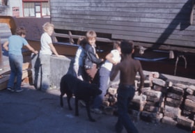
Children on site of Whitechurch Hardware
https://search.heritageburnaby.ca/link/museumdescription16894
- Repository
- Burnaby Village Museum
- Date
- Aug. 1974
- Collection/Fonds
- Burnaby Village Museum fonds
- Description Level
- Item
- Physical Description
- 1 photograph : col. slide ; 35 mm
- Scope and Content
- Photograph of a group of children and a dog gathered to watch the Whitechurch Hardware get raised up in preparation for it to be moved to Heritage Village (Burnaby Village Museum). The building is located at 7685 Sixth Street. Bricks that were removed from the building's chimney are stacked next to…
- Repository
- Burnaby Village Museum
- Collection/Fonds
- Burnaby Village Museum fonds
- Subseries
- Bell's building photographs subseries
- Description Level
- Item
- Physical Description
- 1 photograph : col. slide ; 35 mm
- Scope and Content
- Photograph of a group of children and a dog gathered to watch the Whitechurch Hardware get raised up in preparation for it to be moved to Heritage Village (Burnaby Village Museum). The building is located at 7685 Sixth Street. Bricks that were removed from the building's chimney are stacked next to the building. A building with sign "Tove's Beauty Corner" is visible across the street.
- Geographic Access
- 6th Street
- Street Address
- 7685 6th Street
- Accession Code
- BV020.5.1864
- Access Restriction
- No restrictions
- Reproduction Restriction
- No known restrictions
- Date
- Aug. 1974
- Media Type
- Photograph
- Historic Neighbourhood
- East Burnaby (Historic Neighbourhood)
- Planning Study Area
- Second Street Area
- Scan Resolution
- 2400
- Scale
- 100
- Notes
- Title based on contents of photograph
- Note in blue ink on slide frame reads: "Kids + dog + bricks / from chimney / watching jack up / Whitechurch / on 6th St. / Aug / 74"
Images

Chimney of Whitechurch Hardware
https://search.heritageburnaby.ca/link/museumdescription16897
- Repository
- Burnaby Village Museum
- Date
- Aug. 1974
- Collection/Fonds
- Burnaby Village Museum fonds
- Description Level
- Item
- Physical Description
- 1 photograph : col. slide ; 35 mm
- Scope and Content
- Photograph of the original chimney of the Whitechurch Hardware building located at 7685 Sixth Street. The building was being prepared to be moved by the Nickel Brothers house moving company to Heritage Village (Burnaby Village Museum).
- Repository
- Burnaby Village Museum
- Collection/Fonds
- Burnaby Village Museum fonds
- Subseries
- Bell's building photographs subseries
- Description Level
- Item
- Physical Description
- 1 photograph : col. slide ; 35 mm
- Scope and Content
- Photograph of the original chimney of the Whitechurch Hardware building located at 7685 Sixth Street. The building was being prepared to be moved by the Nickel Brothers house moving company to Heritage Village (Burnaby Village Museum).
- Geographic Access
- 6th Street
- Street Address
- 7685 6th Street
- Accession Code
- BV020.5.1867
- Access Restriction
- No restrictions
- Reproduction Restriction
- No known restrictions
- Date
- Aug. 1974
- Media Type
- Photograph
- Historic Neighbourhood
- East Burnaby (Historic Neighbourhood)
- Planning Study Area
- Second Street Area
- Scan Resolution
- 2400
- Scale
- 100
- Notes
- Title based on contents of photograph
- Note in blue ink on slide frame reads: "Chimney of / Whitechurch (original)"
Images
