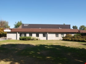
Kensington Arena
https://search.heritageburnaby.ca/link/landmark787
- Repository
- Burnaby Heritage Planning
- Geographic Access
- Curtis Street
- Associated Dates
- 1973
- Heritage Value
- In 1972, the Burnaby Parks Commission considered numerous requests from the community to increase the available ice rink surfaces in the city and voted to build a new full-sized rink instead of adding to the existing municipal rink facility. The new arena was to be situated in North Burnaby and was opened in 1973 adjacent to Kensington Park.
- Planning Study Area
- Parkcrest-Aubrey Area
- Street Address
- 6159 Curtis Street
- Street View URL
- Google Maps Street View
Images
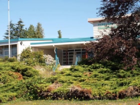
Parkcrest Elementary School
https://search.heritageburnaby.ca/link/landmark784
- Repository
- Burnaby Heritage Planning
- Geographic Access
- Halifax Street
- Associated Dates
- 1960
- Heritage Value
- Parkcrest School was opened in 1960 to accommodate the growing population in the area north of the Lougheed Highway between Holdom and Sperling Avenues. The school was expanded with additional classrooms in 1964 and 1968.
- Planning Study Area
- Parkcrest-Aubrey Area
- Street Address
- 6055 Halifax Street
- Street View URL
- Google Maps Street View

