Narrow Results By
Subject
- Accidents 14
- Accidents - Automobile Accidents 30
- Accidents - Train Accidents 23
- Adminstrative Groups - Committees 4
- Adornment - Jewelry 7
- Adornment - Lapel Pins 1
- Advertising Medium 11
- Advertising Medium - Flyer 3
- Advertising Medium - Poster 16
- Advertising Medium - Signs and Signboards 223
- Aerial Photographs 132
- Agricultural Tools and Equipment 22

Duncan & Margaret McGregor Estate 'Glen-Lyon' New Haven Barn
https://search.heritageburnaby.ca/link/landmark852
- Repository
- Burnaby Heritage Planning
- Description
- Designed in a vernacular architectural style, the New Haven Barn is a large gambrel-roofed barn located on the Edwardian era McGregor Estate 'Glen-Lyon,' overlooking the rich farmland of the Fraser River floodplain and near a ravine and forested area adjacent to Marine Drive in South Burnaby.
- Associated Dates
- 1939
- Formal Recognition
- Heritage Designation, Community Heritage Register
- Other Names
- Home of the Friendless, New Haven Borstal Home for Boys and Youthful Offenders, New Haven Correction Centre
- Street View URL
- Google Maps Street View
- Repository
- Burnaby Heritage Planning
- Other Names
- Home of the Friendless, New Haven Borstal Home for Boys and Youthful Offenders, New Haven Correction Centre
- Geographic Access
- Marine Drive
- Associated Dates
- 1939
- Formal Recognition
- Heritage Designation, Community Heritage Register
- Enactment Type
- Bylaw No. 12183
- Enactment Date
- 11/12/2006
- Description
- Designed in a vernacular architectural style, the New Haven Barn is a large gambrel-roofed barn located on the Edwardian era McGregor Estate 'Glen-Lyon,' overlooking the rich farmland of the Fraser River floodplain and near a ravine and forested area adjacent to Marine Drive in South Burnaby.
- Heritage Value
- The site is historically significant for its association with early social welfare and correctional reform. The estate was sold in 1926 to an inter-denominational religious organization called the Home of the Friendless, which used it as their B.C. headquarters. The organization was charged with several cases of abuse and neglect in 1937, after which a Royal Commission was formed that led to new legislation to regulate and license all private welfare institutions. 'Glen-Lyon' was sold to the provincial government, and was dedicated in 1939 by the Lt.-Gov. E.W. Hamber for use as the New Haven Borstal Home for Boys and Youthful Offenders (later renamed the New Haven Correction Centre). The Borstal movement originated in England in the late nineteenth century, as an alternative to sending young offenders and runaways to prisons by providing reformatories that focused on discipline and vocational skill. This site’s role as the first North American institution devoted to the Borstal School philosophy was historic, and influenced corrections programs across Canada. The New Haven Barn is a significant feature from its development in 1939 as the Borstal School, designed by Chief Provincial Architect Henry Whittaker of the Department of Public Works, and is the only remaining structure of its kind in Burnaby.
- Defining Elements
- Key elements that define the heritage character of the New Haven Barn include its: - gambrel-roofed barn with roof vent with finial, sliding hay loft and access doors, small multi-pane windows, and lapped wooden siding
- Historic Neighbourhood
- Fraser Arm (Historic Neighbourhood)
- Planning Study Area
- Big Bend Area
- Architect
- Henry Whittaker
- Function
- Primary Historic--Estate
- Community
- Burnaby
- Cadastral Identifier
- 003-004-661
- Boundaries
- 'Glen-Lyon' is comprised of a single residential lot located at 4250 Marine Drive, Burnaby.
- Area
- 230873.18
- Contributing Resource
- Building
- Ownership
- Private
- Names
- Whittaker, George
- New Haven Borstal Home for Boys and Youthful Offenders
- New Haven Correction Centre
- Borstal School
- Street Address
- 4250 Marine Drive
- Street View URL
- Google Maps Street View
Images


E.W. Bateman House 'Elworth'
https://search.heritageburnaby.ca/link/landmark538
- Repository
- Burnaby Heritage Planning
- Description
- The E.W. Bateman House is a one-and-one-half storey wood-frame residence set within in a garden landscape. The house and its adjacent garage are the only historic buildings standing on their original site within the Burnaby Village Museum property.
- Associated Dates
- 1922
- Formal Recognition
- Heritage Designation, Community Heritage Register
- Other Names
- Edwin & Mary Bateman Residence
- Street View URL
- Google Maps Street View
- Repository
- Burnaby Heritage Planning
- Other Names
- Edwin & Mary Bateman Residence
- Geographic Access
- Deer Lake Avenue
- Associated Dates
- 1922
- Formal Recognition
- Heritage Designation, Community Heritage Register
- Enactment Type
- Bylaw No. 9807
- Enactment Date
- 23/11/1992
- Description
- The E.W. Bateman House is a one-and-one-half storey wood-frame residence set within in a garden landscape. The house and its adjacent garage are the only historic buildings standing on their original site within the Burnaby Village Museum property.
- Heritage Value
- The E.W. Bateman House was constructed in the Deer Lake Crescent subdivision, that was originally promoted in 1911 as an upper class suburban neighbourhood. It represents one of the first residential developments in the City of Burnaby that required buildings to be of a specific value, thus demonstrating the desire for exclusivity among the successful businessmen who chose to settle in the area. The house and grounds illustrate the reduced scale of upper-class residential construction at a time of modest returning prosperity that followed the end of the First World War, and the social, cultural, lifestyle and leisure sensibilities of the owners in the Deer Lake Crescent subdivision: such values as social aspiration, racial exclusivity, demonstration of architectural taste, and importance of a landscaped garden. The heritage value of the E.W. Bateman House is its comprehensive representation of an upper middle-class suburban residence of the early 1920s. It was built for retired CPR executive Edwin Wettenhall Bateman (1859-1957) and his wife, Mary (Dale) Bateman (1865-1935), by contractor William Dodson in 1922. The Bateman House was designed by English-born and trained architect Enoch Evans (1862-1939) of E. Evans and Son, and is an important surviving residential design by Evans, and a typical example of the eclectic Period Revival influences that were common to domestic architecture in the post-First World War era. The symmetry of the imposing front verandah, supported by exaggerated Ionic columns, gives the relatively-modest house an image of grandeur and formality. Named after Edwin Bateman’s birthplace in Cheshire, England, ‘Elworth’ also symbolizes allegiance to England and the patriotic tenor of the time. The heritage value for this house also lies in its interpretive value within the Burnaby Village Museum. The site is an important cultural feature for the interpretation of Burnaby’s heritage to the public. The E.W. Bateman House was purchased by Burnaby in 1970 and became the focal point for the development of the Museum. Both the interior and exterior of the house have been restored and interpreted to the date of original construction, including recreated room interiors and period furnishings.
- Defining Elements
- The elements that define the heritage character of the E.W. Bateman House include its: - rectangular form and massing with central entry on long side - side gable roof with front shed dormer with cedar shingle cladding - symmetry of front facade - full open front verandah inset under the roofline, supported with Ionic columns - cedar shingle siding - multi-paned double-hung wooden-sash windows, mixture of 6-over-1 and 8-over-1 - symmetrical disposition of fenestration, with double-assembly units on the ground floor - exterior shutters - two flanking brick chimneys on the side elevations - interior room layouts and original interior features such as quality millwork and original hardware - original garage at the rear of the house
- Locality
- Deer Lake Park
- Historic Neighbourhood
- Burnaby Lake (Historic Neighbourhood)
- Planning Study Area
- Morley-Buckingham Area
- Organization
- Burnaby Village Museum
- Architect
- Enoch Evans
- E. Evans and Son
- Builder
- William Dodson
- Function
- Primary Current--Museum
- Primary Historic--Single Dwelling
- Community
- Burnaby
- Cadastral Identifier
- P.I.D. No. 011-030-356 Legal Description: Parcel 1, District Lot 79 and District Lot 85, Group 1, New Westminster District, Reference Plan 77594
- Boundaries
- Burnaby Village Museum is comprised of a single municipally-owned property located at 6501 Deer Lake Avenue, Burnaby.
- Area
- 38,488.63
- Contributing Resource
- Building
- Landscape Feature
- Structure
- Ownership
- Public (local)
- Documentation
- Heritage Site Files: PC77000 20. City of Burnaby Planning and Building Department, 4949 Canada Way, Burnaby, B.C., V5G 1M2
- Subjects
- Buildings - Residential
- Buildings - Residential - Houses
- Buildings - Heritage
- Buildings - Civic - Museums
- Street Address
- 6501 Deer Lake Avenue
- Street View URL
- Google Maps Street View
Images


H.T. Ceperley Estate 'Fairacres' Greenhouse Foundation Wall
https://search.heritageburnaby.ca/link/landmark862
- Repository
- Burnaby Heritage Planning
- Description
- The original rubble stone walls that formed the foundation for a greenhouses adjacent to the Steam Plant Building provided heat to several greenhouses on the estate propoerty. The Root House, which is to the north of the Greenhouse Foundation Wall, provided storage for the farm operation.
- Associated Dates
- 1908
- Formal Recognition
- Heritage Designation, Community Heritage Register
- Repository
- Burnaby Heritage Planning
- Geographic Access
- Deer Lake Avenue
- Associated Dates
- 1908
- Formal Recognition
- Heritage Designation, Community Heritage Register
- Enactment Type
- Bylaw No. 140665
- Enactment Date
- 23/11/1992
- Description
- The original rubble stone walls that formed the foundation for a greenhouses adjacent to the Steam Plant Building provided heat to several greenhouses on the estate propoerty. The Root House, which is to the north of the Greenhouse Foundation Wall, provided storage for the farm operation.
- Heritage Value
- The outbuildings at 'Fairacres' are a rare surviving architecturally-designed ensemble of agricultural structures that exist in complementary harmony with the main estate house. Architect Robert Mackay Fripp (1858-1917), an outspoken advocate of Arts and Crafts design, was retained by the Ceperleys to design several original outbuildings on their estate, which was designed as a country estate with a working farm that included over 10 acres of productive berry and vegetable fields, with a large kitchen garden, a root house to store food, an orchard, and greenhouses heated by steam. The agricultural potential of the Deer Lake area made it one of the first parts of the municipality to attract settlement. In 1909, the Ceperleys built three large greenhouses heated by an adjacent steam plant (Fairacres Steam Plant). The greenhouses featured granite foundation walls, including this one which remains intact. The Ceperleys employed a large staff to manage the estate's agricultural production, including Chinese farm labourers. Produce was grown for use at the estate, and for sale at local markets. Agricultural use of the estate continued when a Catholic order of Benedictine monks purchased the estate as part of the Priory of St. Joseph and the Seminary of Christ the King, and continued to farm the land until 1953.
- Defining Elements
- Key elements that define the heritage character of the ‘Fairacres’ Steam Plant Building include its: - overall spatial arrangement of the Greenhouse Foundation Wall in relation to the Steam Plant Building and the Root House - original rubble stone walls reflecting the Arts and Crafts design aesthetic of the estate buildings.
- Locality
- Deer Lake Park
- Historic Neighbourhood
- Burnaby Lake (Historic Neighbourhood)
- Planning Study Area
- Douglas-Gilpin Area
- Architect
- Robert Mackay Fripp
- Function
- Primary Historic--Outbuilding
- Community
- Burnaby
- Cadastral Identifier
- P.I.D. No. 004-493-311 Legal Description: Block 3 Except: Part subdivided by Plan 26865, District Lot 79, Group 1, New Westminster District, Plan 536
- Boundaries
- ‘Fairacres’ is comprised of a single municipally-owned property located at 6344 Deer Lake Avenue, Burnaby.
- Area
- 17,065.00
- Contributing Resource
- Landscape Feature
- Remains
- Ownership
- Public (local)
- Other Collection
- Burnaby Historical Society, Community Archives: Ceperley Photograph Album
- Documentation
- Heritage Site Files: PC77000 20. City of Burnaby Planning and Building Department, 4949 Canada Way, Burnaby, B.C., V5G 1M2
- Street Address
- 6344 Deer Lake Avenue
Images


H.T. Ceperley Estate 'Fairacres' Root House
https://search.heritageburnaby.ca/link/landmark527
- Repository
- Burnaby Heritage Planning
- Description
- The ‘Fairacres’ Root House is a long, low one-storey masonry building, measuring 4.6 metres by 9.1 metres, with massively buttressed concrete walls and foundations. Built into sloping ground adjacent to the location of the former greenhouses, the surviving orchard and the kitchen entrance of the ma…
- Associated Dates
- 1908
- Formal Recognition
- Heritage Designation, Community Heritage Register
- Repository
- Burnaby Heritage Planning
- Geographic Access
- Deer Lake Avenue
- Associated Dates
- 1908
- Formal Recognition
- Heritage Designation, Community Heritage Register
- Enactment Type
- Bylaw No. 9807
- Enactment Date
- 23/11/1992
- Description
- The ‘Fairacres’ Root House is a long, low one-storey masonry building, measuring 4.6 metres by 9.1 metres, with massively buttressed concrete walls and foundations. Built into sloping ground adjacent to the location of the former greenhouses, the surviving orchard and the kitchen entrance of the main house, 'Fairacres,' this functional structure was used as a frost-free store for fruit and vegetables for the family's use.
- Heritage Value
- The outbuildings at 'Fairacres' are a rare surviving architecturally-designed ensemble of agricultural structures that exist in complementary harmony with the main estate house. Architect Robert Mackay Fripp (1858-1917), an outspoken advocate of Arts and Crafts design, was retained by the Ceperleys to design several original outbuildings on their estate. The Root House is important as a rare surviving, and exceptionally large, example of this building type in the Vancouver region. Unusual in the fact that an architect designed a building of such modest aspirations, it is also remarkable in its method of construction. The use of concrete as a structural material is one of the earliest in the region and extraordinary for its use on such a modest vernacular outbuilding; root cellars were typically built of loose stone. Built in 1908, the Root House was significantly altered in the 1960s and restored to its original design in 2000. The building is significant as an indicator of the market gardening activity in the area around Deer Lake and of the country-house self-sufficiency practiced by the Ceperley family. The Root House illustrates the cultural, aesthetic, and lifestyle values of the Ceperleys in constructing such a large building for storing their own produce.
- Defining Elements
- The outbuildings at 'Fairacres' are a rare surviving architecturally-designed ensemble of agricultural structures that exist in complementary harmony with the main estate house. Architect Robert Mackay Fripp (1858-1917), an outspoken advocate of Arts and Crafts design, was retained by the Ceperleys to design several original outbuildings on their estate. The Root House is important as a rare surviving, and exceptionally large, example of this building type in the Vancouver region. Unusual in the fact that an architect designed a building of such modest aspirations, it is also remarkable in its method of construction. The use of concrete as a structural material is one of the earliest in the region and extraordinary for its use on such a modest vernacular outbuilding; root cellars were typically built of loose stone. Built in 1908, the Root House was significantly altered in the 1960s and restored to its original design in 2000. The building is significant as an indicator of the market gardening activity in the area around Deer Lake and of the country-house self-sufficiency practiced by the Ceperley family. The Root House illustrates the cultural, aesthetic, and lifestyle values of the Ceperleys in constructing such a large building for storing their own produce.
- Locality
- Deer Lake Park
- Historic Neighbourhood
- Burnaby Lake (Historic Neighbourhood)
- Planning Study Area
- Douglas-Gilpin Area
- Architect
- Robert Mackay Fripp
- Function
- Primary Historic--Outbuilding
- Secondary Historic--Food Storage
- Community
- Burnaby
- Cadastral Identifier
- P.I.D. No. 004-493-311 Legal Description: Block 3 Except: Part subdivided by Plan 26865, District Lot 79, Group 1, New Westminster District, Plan 536
- Boundaries
- ‘Fairacres’ is comprised of a single municipally-owned property located at 6344 Deer Lake Avenue, Burnaby.
- Area
- 17,065.00
- Contributing Resource
- Building
- Landscape Feature
- Ownership
- Public (local)
- Other Collection
- Burnaby Historical Society, Community Archives: Ceperley Photograph Album
- Documentation
- Heritage Site Files: PC77000 20. City of Burnaby Planning and Building Department, 4949 Canada Way, Burnaby, B.C., V5G 1M2
- Street Address
- 6344 Deer Lake Avenue
Images


H.T. Ceperley Estate 'Fairacres' Steam Plant Building
https://search.heritageburnaby.ca/link/landmark528
- Repository
- Burnaby Heritage Planning
- Description
- Designed in the British Arts and Crafts style, the ‘Fairacres’ Steam Plant Buiding is a single-storey wood frame building with a gabled roof that originally housed the apparatus for climate control in the greenhouses, formerly located to its north. The original rubble stone walls that formed the fo…
- Associated Dates
- 1908
- Formal Recognition
- Heritage Designation, Community Heritage Register
- Repository
- Burnaby Heritage Planning
- Geographic Access
- Deer Lake Avenue
- Associated Dates
- 1908
- Formal Recognition
- Heritage Designation, Community Heritage Register
- Enactment Type
- Bylaw No. 9807
- Enactment Date
- 23/11/1992
- Description
- Designed in the British Arts and Crafts style, the ‘Fairacres’ Steam Plant Buiding is a single-storey wood frame building with a gabled roof that originally housed the apparatus for climate control in the greenhouses, formerly located to its north. The original rubble stone walls that formed the foundation for the greenhouses stand adjacent. The Steam Plant Building stands as a pendant to the Root House, which is to the north of the former greenhouses.
- Heritage Value
- The outbuildings at 'Fairacres' are a rare surviving architecturally-designed ensemble of agricultural structures that exist in complementary harmony with the main estate house. Architect Robert Mackay Fripp (1858-1917), an outspoken advocate of Arts and Crafts design, was retained by the Ceperleys to design several original outbuildings on their estate. The Ceperleys operated 'Fairacres' with staff, a farm manager and workers, including Chinese, to grow produce for themselves and for sale at local markets. The Steam Plant Building illustrates the market gardening activity of the area around Deer Lake and its importance to the Ceperley family, which valued a year-round supply of fresh fruit and vegetables for the kitchen and flowers for the house. It also illustrates the cultural and aesthetic values of the Ceperleys in retaining an architect to design a functional outbuilding using an accepted and contemporary architectural style. Built in 1908, the Steam Plant Building was significantly altered in the 1960s and restored to its original design in 2000.
- Defining Elements
- Key elements that define the heritage character of the ‘Fairacres’ Steam Plant Building include its: - overall spatial arrangement of the Steam Plant Building in relation to the former greenhouses and the Root House - side gable roof with cedar shingle cladding. - tall brick chimney indicitive of the building's original function. - distinctive Arts and Crafts architectural features such as the shingle wall cladding with decorative shingling under window sills, deep eaves, and pebble-dashed concrete foundation walls - six-paned wooden-sash casement windows - simple functional interior features - rubble stone walls that formed the foundation for the greenhouses
- Locality
- Deer Lake Park
- Historic Neighbourhood
- Burnaby Lake (Historic Neighbourhood)
- Planning Study Area
- Douglas-Gilpin Area
- Architect
- Robert Mackay Fripp
- Function
- Primary Historic--Outbuilding
- Community
- Burnaby
- Cadastral Identifier
- P.I.D. No. 004-493-311 Legal Description: Block 3 Except: Part subdivided by Plan 26865, District Lot 79, Group 1, New Westminster District, Plan 536
- Boundaries
- ‘Fairacres’ is comprised of a single municipally-owned property located at 6344 Deer Lake Avenue, Burnaby.
- Area
- 17,065.00
- Contributing Resource
- Building
- Landscape Feature
- Ownership
- Public (local)
- Other Collection
- Burnaby Historical Society, Community Archives: Ceperley Photograph Album
- Documentation
- Heritage Site Files: PC77000 20. City of Burnaby Planning and Building Department, 4949 Canada Way, Burnaby, B.C., V5G 1M2
- Street Address
- 6344 Deer Lake Avenue
Images

![B.C. Police display in Osoyoos museum, [1987 or 1988] thumbnail](/media/hpo/_Data/_BVM_Images/2000/200400230040.jpg?width=280)
B.C. Police display in Osoyoos museum
https://search.heritageburnaby.ca/link/museumdescription1754
- Repository
- Burnaby Village Museum
- Date
- [1987 or 1988]
- Collection/Fonds
- Burnaby Village Museum Photograph collection
- Description Level
- Item
- Physical Description
- 1 photograph : col. ; 12.5 x 12.5 cm
- Scope and Content
- Photograph of a mannequin, sitting in a reconstructed British Columbia Police office with handcuffs around his wrists (representing a convict). This was part of a museum display in Osoyoos (in the Okanagan Valley).
- Repository
- Burnaby Village Museum
- Collection/Fonds
- Burnaby Village Museum Photograph collection
- Description Level
- Item
- Physical Description
- 1 photograph : col. ; 12.5 x 12.5 cm
- Scope and Content
- Photograph of a mannequin, sitting in a reconstructed British Columbia Police office with handcuffs around his wrists (representing a convict). This was part of a museum display in Osoyoos (in the Okanagan Valley).
- Subjects
- Buildings - Civic - Museums
- Accession Code
- BV004.23.40
- Access Restriction
- Restricted access
- Reproduction Restriction
- May be restricted by third party rights
- Date
- [1987 or 1988]
- Media Type
- Photograph
- Scan Resolution
- 600
- Scan Date
- 09-Jun-09
- Scale
- 100
- Notes
- Title based on contents of photograph
- Note in blue ink on verso of photograph reads: "Sept 87/ Osooy... [sic]"
- Note in black ink on verso of photograph reads: "B.C. Police Display Osoyoos March 1988"
Images
![B.C. Police display in Osoyoos museum, [1987 or 1988] thumbnail](/media/hpo/_Data/_BVM_Images/2000/200400230040.jpg)
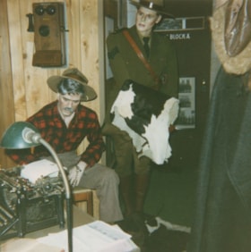
B.C. Police display in Osoyoos museum
https://search.heritageburnaby.ca/link/museumdescription1755
- Repository
- Burnaby Village Museum
- Date
- March 1988
- Collection/Fonds
- Burnaby Village Museum Photograph collection
- Description Level
- Item
- Physical Description
- 1 photograph : col. ; 12.5 x 12.5 cm
- Scope and Content
- Photograph of two mannequins in a reconstructed British Columbia Police office. One is sitting in a chair with handcuffs around his wrists (representing a convict). The other is wearing a British Columbia Police officer uniform and standing in the doorway with a cow hide slung across his arm. This…
- Repository
- Burnaby Village Museum
- Collection/Fonds
- Burnaby Village Museum Photograph collection
- Description Level
- Item
- Physical Description
- 1 photograph : col. ; 12.5 x 12.5 cm
- Scope and Content
- Photograph of two mannequins in a reconstructed British Columbia Police office. One is sitting in a chair with handcuffs around his wrists (representing a convict). The other is wearing a British Columbia Police officer uniform and standing in the doorway with a cow hide slung across his arm. This was part of a museum display in Osoyoos (in the Okanagan Valley).
- Accession Code
- BV004.23.41
- Access Restriction
- Restricted access
- Reproduction Restriction
- May be restricted by third party rights
- Date
- March 1988
- Media Type
- Photograph
- Scan Resolution
- 600
- Scan Date
- 09-Jun-09
- Scale
- 100
- Notes
- Title based on contents of photograph
- Note in black ink on verso of photograph reads: "B.C. Police Display Osoyoos March 1988"
Images


B.C. Police display in Osoyoos museum
https://search.heritageburnaby.ca/link/museumdescription1756
- Repository
- Burnaby Village Museum
- Date
- March 1988
- Collection/Fonds
- Burnaby Village Museum Photograph collection
- Description Level
- Item
- Physical Description
- 1 photograph : col. ; 12.5 x 12.5 cm
- Scope and Content
- Photograph of a mannequin in a reconstructed British Columbia Police office. He is wearing a British Columbia Police officer uniform and sitting at a desk at a typewriter. This was part of a museum display in Osoyoos (in the Okanagan Valley).
- Repository
- Burnaby Village Museum
- Collection/Fonds
- Burnaby Village Museum Photograph collection
- Description Level
- Item
- Physical Description
- 1 photograph : col. ; 12.5 x 12.5 cm
- Scope and Content
- Photograph of a mannequin in a reconstructed British Columbia Police office. He is wearing a British Columbia Police officer uniform and sitting at a desk at a typewriter. This was part of a museum display in Osoyoos (in the Okanagan Valley).
- Accession Code
- BV004.23.42
- Access Restriction
- Restricted access
- Reproduction Restriction
- May be restricted by third party rights
- Date
- March 1988
- Media Type
- Photograph
- Scan Resolution
- 600
- Scan Date
- 09-Jun-09
- Scale
- 100
- Notes
- Title based on contents of photograph
- Note in black ink on verso of photograph reads: "B.C. Police Display Osoyoos March 1988"
Images

![Burnaby Garden Centre, [196-] thumbnail](/media/hpo/_Data/_Archives_Images/_Unrestricted/316/366-032.jpg?width=280)
Burnaby Garden Centre
https://search.heritageburnaby.ca/link/archivedescription97617
- Repository
- City of Burnaby Archives
- Date
- [196-]
- Collection/Fonds
- Burnaby Historical Society fonds
- Description Level
- Item
- Physical Description
- 1 photograph : b&w negative
- Scope and Content
- Photograph of the exterior of the Burnaby Garden Centre with a full pickup truck in the foreground. The Burnaby Garden Centre is located at 3807 East Hastings Street.
- Repository
- City of Burnaby Archives
- Date
- [196-]
- Collection/Fonds
- Burnaby Historical Society fonds
- Subseries
- Municipal record subseries
- Physical Description
- 1 photograph : b&w negative
- Description Level
- Item
- Record No.
- 366-032
- Access Restriction
- No restrictions
- Reproduction Restriction
- Reproduce for fair dealing purposes only
- Accession Number
- BHS1998-12
- Scope and Content
- Photograph of the exterior of the Burnaby Garden Centre with a full pickup truck in the foreground. The Burnaby Garden Centre is located at 3807 East Hastings Street.
- Subjects
- Buildings - Agricultural
- Media Type
- Photograph
- Notes
- Title based on content of photograph
- Geographic Access
- Hastings Street
- Historic Neighbourhood
- Vancouver Heights (Historic Neighbourhood)
- Planning Study Area
- Burnaby Heights Area
Images
![Burnaby Garden Centre, [196-] thumbnail](/media/hpo/_Data/_Archives_Images/_Unrestricted/316/366-032.jpg)
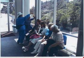
Burnaby Historical Society Visits Stave Lake Powerhouse Museum and Park 2004
https://search.heritageburnaby.ca/link/archivedescription98451
- Repository
- City of Burnaby Archives
- Date
- 2004
- Collection/Fonds
- Burnaby Historical Society fonds
- Description Level
- File
- Physical Description
- 22 photographs : inkjet prints on paper ; 10 cm x 15 cm
- Scope and Content
- File contains photographs of a Burnaby Historical Society trip to the Stave Lake Powerhouse Museum and park picnic in Mission, BC in 2004.
- Repository
- City of Burnaby Archives
- Date
- 2004
- Collection/Fonds
- Burnaby Historical Society fonds
- Series
- Administration series
- Physical Description
- 22 photographs : inkjet prints on paper ; 10 cm x 15 cm
- Description Level
- File
- Record No.
- 633-006
- Access Restriction
- No restrictions
- Reproduction Restriction
- No restrictions
- Accession Number
- 2020-06
- Scope and Content
- File contains photographs of a Burnaby Historical Society trip to the Stave Lake Powerhouse Museum and park picnic in Mission, BC in 2004.
- Media Type
- Photograph
- Notes
- Transcribed title
- Title transcribed from inside cover of photo album
- Photographs were originally contained in a photograph album and removed by Archives staff for preservation purposes. Original order of photographs within the album is maintained.
- Most photographs in file have note on verso identifying individuals depicted
Images

![Burnaby Village Museum carousel tour, [2000] thumbnail](/media/hpo/_Data/_Archives_Images/_Unrestricted/535/535-2676.jpg?width=280)
Burnaby Village Museum carousel tour
https://search.heritageburnaby.ca/link/archivedescription97271
- Repository
- City of Burnaby Archives
- Date
- [2000]
- Collection/Fonds
- Burnaby NewsLeader photograph collection
- Description Level
- Item
- Physical Description
- 1 photograph (tiff) : col.
- Scope and Content
- Photograph of Dr. Garnett Reynolds, of the Pacific Coast Association of Port Authorities, and Mildred Reynolds speaking with Steve Alderson, the carousel operator at the Burnaby Village Museum. Alderson is dressed in a period costume and is standing on the inside of the barrier around the old carou…
- Repository
- City of Burnaby Archives
- Date
- [2000]
- Collection/Fonds
- Burnaby NewsLeader photograph collection
- Physical Description
- 1 photograph (tiff) : col.
- Description Level
- Item
- Record No.
- 535-2676
- Access Restriction
- No restrictions
- Reproduction Restriction
- Reproduce for fair dealing purposes only
- Accession Number
- 2018-12
- Scope and Content
- Photograph of Dr. Garnett Reynolds, of the Pacific Coast Association of Port Authorities, and Mildred Reynolds speaking with Steve Alderson, the carousel operator at the Burnaby Village Museum. Alderson is dressed in a period costume and is standing on the inside of the barrier around the old carousel, and some of the carousel horses are visible in the background.
- Names
- Burnaby Village Museum
- Media Type
- Photograph
- Photographer
- Bartel, Mario
- Notes
- Title based on caption
- Collected by editorial for use in a September 2000 issue of the Burnaby NewsLeader
- Caption from metadata: "Dr. Garnett Reynolds, of Port Alberni, and his wife, Mildred, admire the pins worn by Burnaby Village Museum's carousel operator, Steve Alderson. Reynolds is a life member of the Pacific Coast Association of Port Authorities, and he was on a tour of the museum with a group of port administrators from around the world."
- Street Address
- 4900 Deer Lake Avenue
- 6501 Deer Lake Avenue
- Historic Neighbourhood
- Burnaby Lake (Historic Neighbourhood)
- Planning Study Area
- Morley-Buckingham Area
Images
![Burnaby Village Museum carousel tour, [2000] thumbnail](/media/hpo/_Data/_Archives_Images/_Unrestricted/535/535-2676.jpg)
![Burnaby Village Museum Fall Fair, [2002] thumbnail](/media/hpo/_Data/_Archives_Images/_Unrestricted/535/535-2763-2.jpg?width=280)
Burnaby Village Museum Fall Fair
https://search.heritageburnaby.ca/link/archivedescription97388
- Repository
- City of Burnaby Archives
- Date
- [2002]
- Collection/Fonds
- Burnaby NewsLeader photograph collection
- Description Level
- File
- Physical Description
- 2 photographs (tiff) : col.
- Scope and Content
- File contains photographs of the Burnaby Village Museum's Fall Fair. Photographs depict four-year-old Jeffrey Dykstra during the watermelon eating contest and 12-year-old David Marino stuffing a scarecrow during another competition.
- Repository
- City of Burnaby Archives
- Date
- [2002]
- Collection/Fonds
- Burnaby NewsLeader photograph collection
- Physical Description
- 2 photographs (tiff) : col.
- Description Level
- File
- Record No.
- 535-2763
- Access Restriction
- No restrictions
- Reproduction Restriction
- No restrictions
- Accession Number
- 2018-12
- Scope and Content
- File contains photographs of the Burnaby Village Museum's Fall Fair. Photographs depict four-year-old Jeffrey Dykstra during the watermelon eating contest and 12-year-old David Marino stuffing a scarecrow during another competition.
- Media Type
- Photograph
- Photographer
- Bartel, Mario
- Notes
- Title based on caption
- Collected by editorial for use in a September 2002 issue of the Burnaby NewsLeader
- Caption from metadata for 535-2763-1: "Jeffrey Dykstra, 4, digs into a slice of watermelon, at the watermelon eating contest at Burnaby Village Museum's annual Fall Fair on Saturday. Other events at the traditional fair included a scarecrow building contest, tests of strength, a palm reader and a chance to "milk a cow.""
- Caption from metadata for 535-2763-2: "David Marino, 12, stuffs his scarecrow at a scarecrow building competition, one of the traditional Fall Fair events at Burnaby Village Museum's closing weekend celebration."
- Geographic Access
- Deer Lake Avenue
- Street Address
- 4900 Deer Lake Avenue
- 6501 Deer Lake Avenue
- Historic Neighbourhood
- Burnaby Lake (Historic Neighbourhood)
- Planning Study Area
- Morley-Buckingham Area
Images
![Burnaby Village Museum Fall Fair, [2002] thumbnail](/media/hpo/_Data/_Archives_Images/_Unrestricted/535/535-2763-2.jpg)
![Burnaby Village Museum Fall Fair, [1999] thumbnail](/media/hpo/_Data/_Archives_Images/_Unrestricted/535/535-3339-1.jpg?width=280)
Burnaby Village Museum Fall Fair
https://search.heritageburnaby.ca/link/archivedescription98315
- Repository
- City of Burnaby Archives
- Date
- [1999]
- Collection/Fonds
- Burnaby NewsLeader photograph collection
- Description Level
- File
- Physical Description
- 3 photographs (tiff) : col.
- Scope and Content
- File contains photographs of the Fall Fair at the Burnaby Village Museum. Photographs depict square dancers performing in front of the Museum's church; Amanda King in period costume and seated beneath a parasol; and a young child viewing two chicks in the petting zoo.
- Repository
- City of Burnaby Archives
- Date
- [1999]
- Collection/Fonds
- Burnaby NewsLeader photograph collection
- Physical Description
- 3 photographs (tiff) : col.
- Description Level
- File
- Record No.
- 535-3339
- Access Restriction
- No restrictions
- Reproduction Restriction
- No restrictions
- Accession Number
- 2018-12
- Scope and Content
- File contains photographs of the Fall Fair at the Burnaby Village Museum. Photographs depict square dancers performing in front of the Museum's church; Amanda King in period costume and seated beneath a parasol; and a young child viewing two chicks in the petting zoo.
- Subjects
- Events - Festivals
- Exhibitions - Fairs
- Exhibitions - Burnaby Village Museum
- Buildings - Civic - Museums
- Performances
- Names
- Burnaby Village Museum
- Media Type
- Photograph
- Notes
- Title based on caption
- Collected by editorial for use in a September 1999 issue of the Burnaby NewsLeader
- Caption from metadata for 535-3339-1: "Square Dancers perform on main street at Bby Village Museum's Fall Fair on the weekend"
- Caption from metadata for 535-3339-2: "Bby Village Volunteer Amanda King watches over the petting zoo in the afternoon sun."
- Caption from metadata for 535-3339-3: "Talia Tvergyak gets up close and personal with some baby chicks at the petting zoo in Burnaby Village Museum."
- Geographic Access
- Deer Lake Avenue
- Street Address
- 6501 Deer Lake Avenue
- Historic Neighbourhood
- Burnaby Lake (Historic Neighbourhood)
- Planning Study Area
- Morley-Buckingham Area
Images
![Burnaby Village Museum Fall Fair, [1999] thumbnail](/media/hpo/_Data/_Archives_Images/_Unrestricted/535/535-3339-1.jpg)
![Burnaby Village Museum film set, [2002] thumbnail](/media/hpo/_Data/_Archives_Images/_Unrestricted/535/535-2752.jpg?width=280)
Burnaby Village Museum film set
https://search.heritageburnaby.ca/link/archivedescription97376
- Repository
- City of Burnaby Archives
- Date
- [2002]
- Collection/Fonds
- Burnaby NewsLeader photograph collection
- Description Level
- Item
- Physical Description
- 1 photograph (tiff) : col.
- Scope and Content
- Photograph of two unidentified people standing underneath a ladder and large lights on a film set at Burnaby Village Museum.
- Repository
- City of Burnaby Archives
- Date
- [2002]
- Collection/Fonds
- Burnaby NewsLeader photograph collection
- Physical Description
- 1 photograph (tiff) : col.
- Description Level
- Item
- Record No.
- 535-2752
- Access Restriction
- No restrictions
- Reproduction Restriction
- No restrictions
- Accession Number
- 2018-12
- Scope and Content
- Photograph of two unidentified people standing underneath a ladder and large lights on a film set at Burnaby Village Museum.
- Names
- Burnaby Village Museum
- Media Type
- Photograph
- Photographer
- Bartel, Mario
- Notes
- Title based on caption
- Collected by editorial for use in a July 2002 issue of the Burnaby NewsLeader
- Caption from metadata: "Burnaby Village Museum has become a popular location for filmmakers looking for a period set, or a quaint village setting."
- Geographic Access
- Deer Lake Avenue
- Street Address
- 4900 Deer Lake Avenue
- 6501 Deer Lake Avenue
- Historic Neighbourhood
- Burnaby Lake (Historic Neighbourhood)
- Planning Study Area
- Morley-Buckingham Area
Images
![Burnaby Village Museum film set, [2002] thumbnail](/media/hpo/_Data/_Archives_Images/_Unrestricted/535/535-2752.jpg)
![Burnaby Village Museum pumpkin patch, [2000] thumbnail](/media/hpo/_Data/_Archives_Images/_Unrestricted/535/535-2682.jpg?width=280)
Burnaby Village Museum pumpkin patch
https://search.heritageburnaby.ca/link/archivedescription97285
- Repository
- City of Burnaby Archives
- Date
- [2000]
- Collection/Fonds
- Burnaby NewsLeader photograph collection
- Description Level
- Item
- Physical Description
- 1 photograph (tiff) : col.
- Scope and Content
- Photograph of Tony Guerriero, a groundskeeper, checking on a pumpkin growing in a garden at the Burnaby Village Museum.
- Repository
- City of Burnaby Archives
- Date
- [2000]
- Collection/Fonds
- Burnaby NewsLeader photograph collection
- Physical Description
- 1 photograph (tiff) : col.
- Description Level
- Item
- Record No.
- 535-2682
- Access Restriction
- No restrictions
- Reproduction Restriction
- Reproduce for fair dealing purposes only
- Accession Number
- 2018-12
- Scope and Content
- Photograph of Tony Guerriero, a groundskeeper, checking on a pumpkin growing in a garden at the Burnaby Village Museum.
- Names
- Burnaby Village Museum
- Media Type
- Photograph
- Photographer
- Bartel, Mario
- Notes
- Title based on caption
- Collected by editorial for use in a September 2000 issue of the Burnaby NewsLeader
- Caption from metadata: "Tony Guerriero, a groundsman at Burnaby Village Museum, checks the progress of the Atlantic Dill pumpkins, as the Museum gets ready for its second annual Fall Fair, Sept. 16."
- Geographic Access
- Deer Lake Avenue
- Street Address
- 4900 Deer Lake Avenue
- 6501 Deer Lake Avenue
- Historic Neighbourhood
- Burnaby Lake (Historic Neighbourhood)
- Planning Study Area
- Morley-Buckingham Area
Images
![Burnaby Village Museum pumpkin patch, [2000] thumbnail](/media/hpo/_Data/_Archives_Images/_Unrestricted/535/535-2682.jpg)
![Burnaby Village Museum season opening, [2002] thumbnail](/media/hpo/_Data/_Archives_Images/_Unrestricted/535/535-2345.jpg?width=280)
Burnaby Village Museum season opening
https://search.heritageburnaby.ca/link/archivedescription96746
- Repository
- City of Burnaby Archives
- Date
- [2002]
- Collection/Fonds
- Burnaby NewsLeader photograph collection
- Description Level
- Item
- Physical Description
- 1 photograph (tiff) : col.
- Scope and Content
- Photograph of Alodia Mulingtapang shining a Model "A" car that is part of an exhibition at Burnaby Village Museum, before its opening for the season. One of the Museum's streets and its businesses, including the Ice Cream Parlour, are visible in the background.
- Repository
- City of Burnaby Archives
- Date
- [2002]
- Collection/Fonds
- Burnaby NewsLeader photograph collection
- Physical Description
- 1 photograph (tiff) : col.
- Description Level
- Item
- Record No.
- 535-2345
- Access Restriction
- No restrictions
- Reproduction Restriction
- No restrictions
- Accession Number
- 2018-12
- Scope and Content
- Photograph of Alodia Mulingtapang shining a Model "A" car that is part of an exhibition at Burnaby Village Museum, before its opening for the season. One of the Museum's streets and its businesses, including the Ice Cream Parlour, are visible in the background.
- Subjects
- Exhibitions - Burnaby Village Museum
- Buildings - Civic - Museums
- Transportation - Automobiles
- Names
- Burnaby Village Museum
- Media Type
- Photograph
- Photographer
- Bartel, Mario
- Notes
- Title based on caption
- Collected by editorial for use in a May 2002 issue of the Burnaby NewsLeader
- Caption from metadata: "Alodia Mulingtapang shines up the old Model "A" at Burnaby Village Museum, as the Museum prepares to open for the season this weekend."
- Geographic Access
- Deer Lake Avenue
- Street Address
- 4900 Deer Lake Avenue
- 6501 Deer Lake Avenue
- Historic Neighbourhood
- Burnaby Lake (Historic Neighbourhood)
- Planning Study Area
- Morley-Buckingham Area
Images
![Burnaby Village Museum season opening, [2002] thumbnail](/media/hpo/_Data/_Archives_Images/_Unrestricted/535/535-2345.jpg)
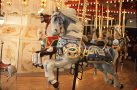
![Carousel at Burnaby Village Museum, [1999] thumbnail](/media/hpo/_Data/_Archives_Images/_Unrestricted/535/535-3135.jpg?width=280)
Carousel at Burnaby Village Museum
https://search.heritageburnaby.ca/link/archivedescription98055
- Repository
- City of Burnaby Archives
- Date
- [1999]
- Collection/Fonds
- Burnaby NewsLeader photograph collection
- Description Level
- Item
- Physical Description
- 1 photograph (tiff) : b&w
- Scope and Content
- Photograph of an unidentified child riding the carousel at Burnaby Village Museum.
- Repository
- City of Burnaby Archives
- Date
- [1999]
- Collection/Fonds
- Burnaby NewsLeader photograph collection
- Physical Description
- 1 photograph (tiff) : b&w
- Description Level
- Item
- Record No.
- 535-3135
- Access Restriction
- No restrictions
- Reproduction Restriction
- No restrictions
- Accession Number
- 2018-12
- Scope and Content
- Photograph of an unidentified child riding the carousel at Burnaby Village Museum.
- Names
- Burnaby Village Museum
- Media Type
- Photograph
- Notes
- Title based on original file name
- Collected by editorial for use in a March 1999 issue of the Burnaby NewsLeader
- Geographic Access
- Deer Lake Avenue
- Street Address
- 4900 Deer Lake Avenue
- 6501 Deer Lake Avenue
- Historic Neighbourhood
- Burnaby Lake (Historic Neighbourhood)
- Planning Study Area
- Morley-Buckingham Area
Images
![Carousel at Burnaby Village Museum, [1999] thumbnail](/media/hpo/_Data/_Archives_Images/_Unrestricted/535/535-3135.jpg)
Carousel Opening
https://search.heritageburnaby.ca/link/archivedescription91712
- Repository
- City of Burnaby Archives
- Date
- March 27, 1993
- Collection/Fonds
- Doreen Lawson fonds
- Description Level
- File
- Physical Description
- 17 photographs : col. slides ; 35 mm
- Scope and Content
- File consists of photographs of the Burnaby Centennial Park Carousel grand opening on March 27, 1993 at the Burnaby Village Museum. Individuals depicted riding the carousel include City Councillor Derek Corrigan, City Manager Bob Moncur, and City staff member Denis Nokony.
- Repository
- City of Burnaby Archives
- Date
- March 27, 1993
- Collection/Fonds
- Doreen Lawson fonds
- Physical Description
- 17 photographs : col. slides ; 35 mm
- Description Level
- File
- Record No.
- 618-030
- Access Restriction
- No restrictions
- Reproduction Restriction
- No restrictions
- Accession Number
- 2015-15
- Scope and Content
- File consists of photographs of the Burnaby Centennial Park Carousel grand opening on March 27, 1993 at the Burnaby Village Museum. Individuals depicted riding the carousel include City Councillor Derek Corrigan, City Manager Bob Moncur, and City staff member Denis Nokony.
- Subjects
- Buildings - Civic - Museums
- Recreational Devices - Carousels
- Officials - Alderman and Councillors
- Names
- Burnaby Village Museum
- Media Type
- Photograph
- Photographer
- Lawson, Doreen A.
- Notes
- Transcribed title
- Title transcribed from label on slide sleeve
- Street Address
- 6501 Deer Lake Avenue
- Historic Neighbourhood
- Burnaby Lake (Historic Neighbourhood)
- Planning Study Area
- Morley-Buckingham Area
Images

![Carousel ride at Burnaby Village Museum, [2003] thumbnail](/media/hpo/_Data/_Archives_Images/_Unrestricted/535/535-1723.jpg?width=280)
Carousel ride at Burnaby Village Museum
https://search.heritageburnaby.ca/link/archivedescription95953
- Repository
- City of Burnaby Archives
- Date
- [2003]
- Collection/Fonds
- Burnaby NewsLeader photograph collection
- Description Level
- Item
- Physical Description
- 1 photograph (tiff) : col.
- Scope and Content
- Photograph of a young child riding the carousel at Burnaby Village Museum during the Burnaby Multicultural Festival. The child's parent stands next to them and the lights of the carousel blur in the background.
- Repository
- City of Burnaby Archives
- Date
- [2003]
- Collection/Fonds
- Burnaby NewsLeader photograph collection
- Physical Description
- 1 photograph (tiff) : col.
- Description Level
- Item
- Record No.
- 535-1723
- Access Restriction
- No restrictions
- Reproduction Restriction
- No restrictions
- Accession Number
- 2018-12
- Scope and Content
- Photograph of a young child riding the carousel at Burnaby Village Museum during the Burnaby Multicultural Festival. The child's parent stands next to them and the lights of the carousel blur in the background.
- Names
- Burnaby Village Museum
- Media Type
- Photograph
- Photographer
- Flanagan, Colleen
- Notes
- Title based on caption
- Collected by editorial for use in an August 2003 issue of the Burnaby NewsLeader
- Caption from metadata: "Kate Wong, 3, enjoys a ride on the indoor carousal Saturday afternoon at Burnaby Village Museum while taking in the Burnaby Multicultural Fest."
- Geographic Access
- Deer Lake Avenue
- Street Address
- 6501 Deer Lake Avenue
- Historic Neighbourhood
- Burnaby Lake (Historic Neighbourhood)
- Planning Study Area
- Morley-Buckingham Area
Images
![Carousel ride at Burnaby Village Museum, [2003] thumbnail](/media/hpo/_Data/_Archives_Images/_Unrestricted/535/535-1723.jpg)
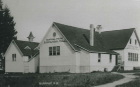
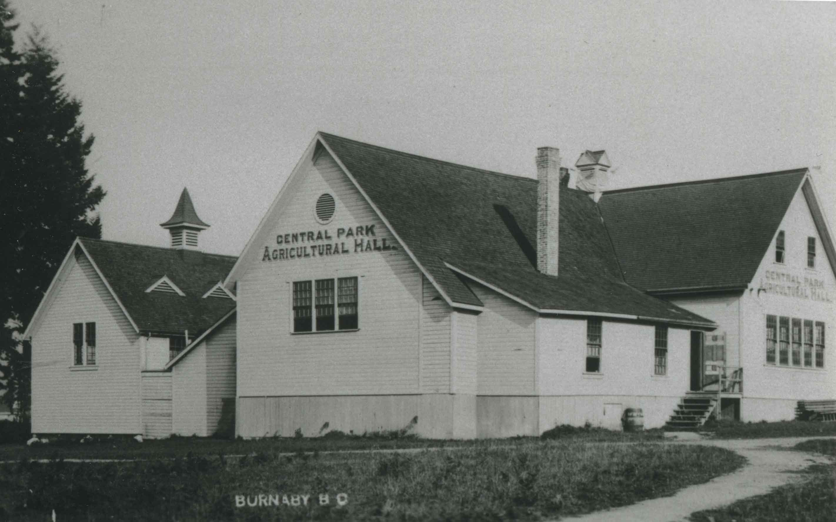
Central Park Agricultural Hall
https://search.heritageburnaby.ca/link/archivedescription36671
- Repository
- City of Burnaby Archives
- Date
- 1920 (date of original), copied 1992
- Collection/Fonds
- Burnaby Historical Society fonds
- Description Level
- Item
- Physical Description
- 1 photograph : b&w ; 10.1 x 14.9 cm print
- Scope and Content
- Photograph of the Central Park Agricultural Hall which was built on the triangular part of the park at Kingsway near Patterson.
- Repository
- City of Burnaby Archives
- Date
- 1920 (date of original), copied 1992
- Collection/Fonds
- Burnaby Historical Society fonds
- Subseries
- Burnaby Centennial Anthology subseries
- Physical Description
- 1 photograph : b&w ; 10.1 x 14.9 cm print
- Description Level
- Item
- Record No.
- 315-026
- Access Restriction
- No restrictions
- Reproduction Restriction
- No known restrictions
- Accession Number
- BHS1994-04
- Scope and Content
- Photograph of the Central Park Agricultural Hall which was built on the triangular part of the park at Kingsway near Patterson.
- Subjects
- Buildings - Agricultural
- Media Type
- Photograph
- Notes
- Title based on contents of photograph
- Copy taken from original b&w photographic postcard
- Geographic Access
- Central Park
- Imperial Street
- Street Address
- 3883 Imperial Street
- Historic Neighbourhood
- Central Park (Historic Neighbourhood)
- Planning Study Area
- Maywood Area
Images