Narrow Results By
Subject
- Accidents - Automobile Accidents 1
- Advertising Medium 3
- Advertising Medium - Signs and Signboards 83
- Aerial Photographs 26
- Agricultural Tools and Equipment 1
- Agricultural Tools and Equipment - Plows 4
- Agriculture 2
- Agriculture - Crops 8
- Agriculture - Farms 53
- Agriculture - Fruit and Berries 11
- Agriculture - Poultry 4
- Animals - Birds 2
![Buildings at the submarine works yard, [1917] (date of original), copied 2004 thumbnail](/media/hpo/_Data/_Archives_Images/_Unrestricted/371/466-004.jpg?width=280)
Buildings at the submarine works yard
https://search.heritageburnaby.ca/link/archivedescription38605
- Repository
- City of Burnaby Archives
- Date
- [1917] (date of original), copied 2004
- Collection/Fonds
- Burnaby Historical Society fonds
- Description Level
- Item
- Physical Description
- 1 photograph : b&w ; 20 x 28 cm print
- Scope and Content
- Photograph of a large building at the site of the submarine works yard in Barnet. During World War One, the Royal Russian Navy contracted with a Seattle-based company to build submarines for Russia, but American neutrality in the war prevented the subs from being built in the United States. Instea…
- Repository
- City of Burnaby Archives
- Date
- [1917] (date of original), copied 2004
- Collection/Fonds
- Burnaby Historical Society fonds
- Subseries
- Jim Wolf subseries
- Physical Description
- 1 photograph : b&w ; 20 x 28 cm print
- Description Level
- Item
- Record No.
- 466-004
- Access Restriction
- No restrictions
- Reproduction Restriction
- No known restrictions
- Accession Number
- BHS2004-9
- Scope and Content
- Photograph of a large building at the site of the submarine works yard in Barnet. During World War One, the Royal Russian Navy contracted with a Seattle-based company to build submarines for Russia, but American neutrality in the war prevented the subs from being built in the United States. Instead, the company operated a facility at Barnet to complete the contract.
- Subjects
- Buildings - Industrial
- Transportation - Submarines
- Wars - World War, 1914-1918
- Occupations - Labourers
- Names
- Royal Russian Navy
- Media Type
- Photograph
- Notes
- Title based on contents of photograph.
- Geographic Access
- Barnet Village
- Barnet Road
- Street Address
- 8774 Barnet Road
- Historic Neighbourhood
- Barnet (Historic Neighbourhood)
- Planning Study Area
- Burnaby Mountain Area
Images
![Buildings at the submarine works yard, [1917] (date of original), copied 2004 thumbnail](/media/hpo/_Data/_Archives_Images/_Unrestricted/371/466-004.jpg)
![Headquarter buildings at the submarine works yard, [1917] (date of original), copied 2004 thumbnail](/media/hpo/_Data/_Archives_Images/_Unrestricted/371/466-001.jpg?width=280)
Headquarter buildings at the submarine works yard
https://search.heritageburnaby.ca/link/archivedescription38602
- Repository
- City of Burnaby Archives
- Date
- [1917] (date of original), copied 2004
- Collection/Fonds
- Burnaby Historical Society fonds
- Description Level
- Item
- Physical Description
- 1 photograph : b&w ; 20 x 28 cm print
- Scope and Content
- Photograph of the headquarter buildings at the submarine works yard at Barnet. During World War One, the Royal Russian Navy contracted with a Seattle-based company to build submarines for Russia, but American neutrality in the war prevented the subs from being built in the United States. Instead, …
- Repository
- City of Burnaby Archives
- Date
- [1917] (date of original), copied 2004
- Collection/Fonds
- Burnaby Historical Society fonds
- Subseries
- Jim Wolf subseries
- Physical Description
- 1 photograph : b&w ; 20 x 28 cm print
- Description Level
- Item
- Record No.
- 466-001
- Access Restriction
- No restrictions
- Reproduction Restriction
- No known restrictions
- Accession Number
- BHS2004-9
- Scope and Content
- Photograph of the headquarter buildings at the submarine works yard at Barnet. During World War One, the Royal Russian Navy contracted with a Seattle-based company to build submarines for Russia, but American neutrality in the war prevented the subs from being built in the United States. Instead, the company operated a facility at Barnet to complete the contract.
- Names
- Royal Russian Navy
- Media Type
- Photograph
- Notes
- Title based on contents of photograph
- Geographic Access
- Barnet Road
- Barnet Village
- Street Address
- 8774 Barnet Road
- Historic Neighbourhood
- Barnet (Historic Neighbourhood)
- Planning Study Area
- Burnaby Mountain Area
Images
![Headquarter buildings at the submarine works yard, [1917] (date of original), copied 2004 thumbnail](/media/hpo/_Data/_Archives_Images/_Unrestricted/371/466-001.jpg)
![Headquarter buildings at the submarine works yard, [1917] (date of original), copied 2004 thumbnail](/media/hpo/_Data/_Archives_Images/_Unrestricted/371/466-002.jpg?width=280)
Headquarter buildings at the submarine works yard
https://search.heritageburnaby.ca/link/archivedescription38603
- Repository
- City of Burnaby Archives
- Date
- [1917] (date of original), copied 2004
- Collection/Fonds
- Burnaby Historical Society fonds
- Description Level
- Item
- Physical Description
- 1 photograph : b&w ; 20 x 28 cm print
- Scope and Content
- Photograph of the headquarters of the submarine works yard at Barnet. During World War One, the Royal Russian Navy contracted with a Seattle-based company to build submarines for Russia, but American neutrality in the war prevented the subs from being built in the United States. Instead, the compan…
- Repository
- City of Burnaby Archives
- Date
- [1917] (date of original), copied 2004
- Collection/Fonds
- Burnaby Historical Society fonds
- Subseries
- Jim Wolf subseries
- Physical Description
- 1 photograph : b&w ; 20 x 28 cm print
- Description Level
- Item
- Record No.
- 466-002
- Access Restriction
- No restrictions
- Reproduction Restriction
- No known restrictions
- Accession Number
- BHS2004-9
- Scope and Content
- Photograph of the headquarters of the submarine works yard at Barnet. During World War One, the Royal Russian Navy contracted with a Seattle-based company to build submarines for Russia, but American neutrality in the war prevented the subs from being built in the United States. Instead, the company operated a facility at Barnet to complete the contract.
- Subjects
- Buildings - Industrial
- Transportation - Submarines
- Wars - World War, 1914-1918
- Occupations - Labourers
- Names
- Royal Russian Navy
- Media Type
- Photograph
- Notes
- Title based on contents of photograph
- Geographic Access
- Barnet Road
- Barnet Village
- Street Address
- 8774 Barnet Road
- Historic Neighbourhood
- Barnet (Historic Neighbourhood)
- Planning Study Area
- Burnaby Mountain Area
Images
![Headquarter buildings at the submarine works yard, [1917] (date of original), copied 2004 thumbnail](/media/hpo/_Data/_Archives_Images/_Unrestricted/371/466-002.jpg)
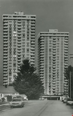
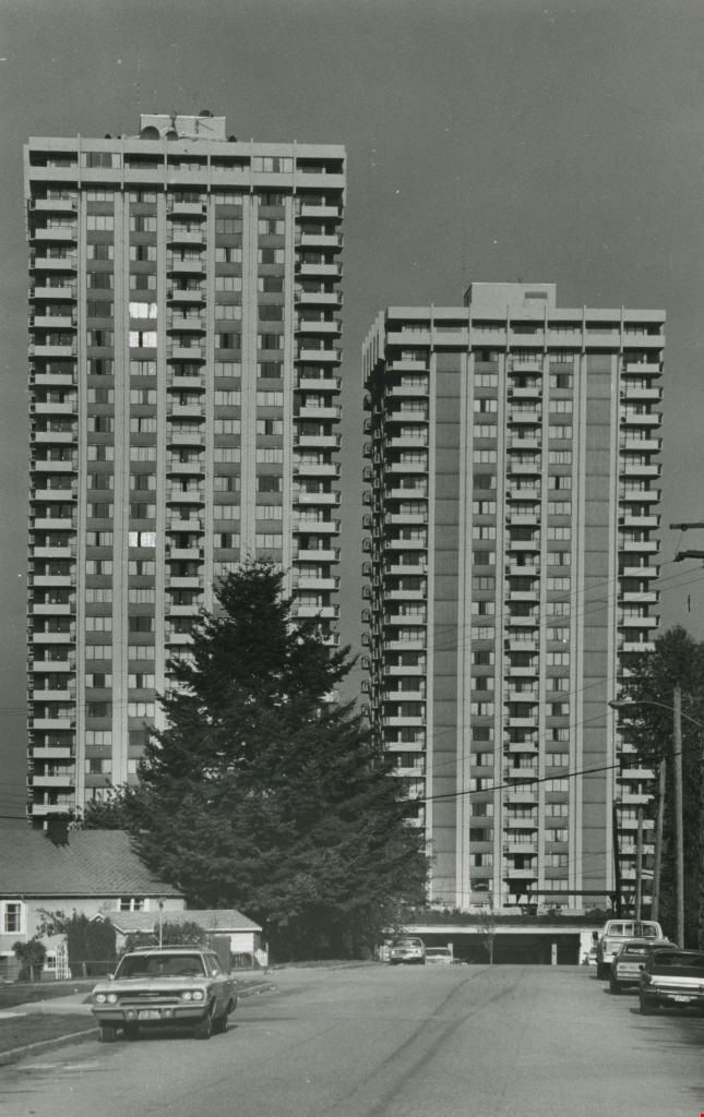
High-rise apartment buildings
https://search.heritageburnaby.ca/link/archivedescription45393
- Repository
- City of Burnaby Archives
- Date
- 1979
- Collection/Fonds
- Columbian Newspaper collection
- Description Level
- Item
- Physical Description
- 1 photograph : b&w ; 23 x 14.5 cm
- Scope and Content
- Photograph of two high-rise apartment buildings.
- Repository
- City of Burnaby Archives
- Date
- 1979
- Collection/Fonds
- Columbian Newspaper collection
- Physical Description
- 1 photograph : b&w ; 23 x 14.5 cm
- Description Level
- Item
- Record No.
- 480-288
- Access Restriction
- No restrictions
- Reproduction Restriction
- No restrictions
- Accession Number
- 2003-02
- Scope and Content
- Photograph of two high-rise apartment buildings.
- Subjects
- Buildings - Residential - Apartments
- Media Type
- Photograph
- Photographer
- Hodge, Craig
- Notes
- Title based on contents of photograph
- Newspaper clipping attached to verso of photograph reads: "Highrises, sunlight stealers or sophisticated urban structures?"
Images

Simon Fraser University Buildings
https://search.heritageburnaby.ca/link/archivedescription37406
- Repository
- City of Burnaby Archives
- Date
- 1970
- Collection/Fonds
- Burnaby Historical Society fonds
- Description Level
- Item
- Physical Description
- 1 photograph : col. postcard ; 9 x 14 cm
- Scope and Content
- Photographic postcard taken looking north towards Simon Fraser University. The caption on the back of the postcard reads: "The aerial view shows part of the university buildings on Burnaby Mountain, with Burrard Inlet, Indian Arm and the North Shore Mountains in the background."
- Repository
- City of Burnaby Archives
- Date
- 1970
- Collection/Fonds
- Burnaby Historical Society fonds
- Subseries
- Robert Prittie subseries
- Physical Description
- 1 photograph : col. postcard ; 9 x 14 cm
- Description Level
- Item
- Record No.
- 369-005
- Access Restriction
- No restrictions
- Reproduction Restriction
- Reproduce for fair dealing purposes only
- Accession Number
- BHS1999-01
- Scope and Content
- Photographic postcard taken looking north towards Simon Fraser University. The caption on the back of the postcard reads: "The aerial view shows part of the university buildings on Burnaby Mountain, with Burrard Inlet, Indian Arm and the North Shore Mountains in the background."
- Subjects
- Aerial Photographs
- Buildings - Schools - Universities and Colleges
- Geographic Features - Mountains
- Documentary Artifacts - Postcards
- Names
- Simon Fraser University
- Media Type
- Photograph
- Notes
- Title based on caption
- Geographic Access
- University Drive
- Street Address
- 8888 University Drive
- Planning Study Area
- Burnaby Mountain Area
Images


Parkcrest Plaza
https://search.heritageburnaby.ca/link/archivedescription93653
- Repository
- City of Burnaby Archives
- Date
- October 23, 1977
- Collection/Fonds
- Burnaby Public Library Contemporary Visual Archive Project
- Description Level
- Item
- Physical Description
- 1 photograph : b&w ; 12.5 x 17.5 cm
- Scope and Content
- Photograph of the Parkcrest Plaza shopping centre at Sperling and Broadway. The photograph is taken from across the parking lot and lawn, facing west. Signs for the plaza's businesses include Fresh Foods and Bank of Nova Scotia, and homes and apartment buildings are in the distance.
- Repository
- City of Burnaby Archives
- Date
- October 23, 1977
- Collection/Fonds
- Burnaby Public Library Contemporary Visual Archive Project
- Physical Description
- 1 photograph : b&w ; 12.5 x 17.5 cm
- Description Level
- Item
- Record No.
- 556-610
- Access Restriction
- No restrictions
- Reproduction Restriction
- Reproduce for fair dealing purposes only
- Accession Number
- 2017-57
- Scope and Content
- Photograph of the Parkcrest Plaza shopping centre at Sperling and Broadway. The photograph is taken from across the parking lot and lawn, facing west. Signs for the plaza's businesses include Fresh Foods and Bank of Nova Scotia, and homes and apartment buildings are in the distance.
- Subjects
- Buildings - Commercial - Grocery Stores
- Buildings - Commercial - Malls
- Buildings - Commercial - Banks
- Buildings - Commercial - Stores
- Media Type
- Photograph
- Photographer
- Chapman, Fred
- Notes
- Title taken from project information form
- Accompanied by a project information form and 1 photograph (b&w negative ; 9.5 x 12.5 cm)
- BPL no. 60
- Geographic Access
- Sperling Avenue
- Broadway
- Street Address
- 5901 Sperling Avenue
- Planning Study Area
- Parkcrest-Aubrey Area
Images

![3700 block of Hastings Street, [2000] thumbnail](/media/hpo/_Data/_Archives_Images/_Unrestricted/535/535-3066.jpg?width=280)
3700 block of Hastings Street
https://search.heritageburnaby.ca/link/archivedescription97940
- Repository
- City of Burnaby Archives
- Date
- [2000]
- Collection/Fonds
- Burnaby NewsLeader photograph collection
- Description Level
- Item
- Physical Description
- 1 photograph (tiff) : b&w
- Scope and Content
- Photograph of the 3700 block of Hastings Street in North Burnaby, looking southeast. Kato Japanese Chinese Restaurant is one of the visible businesses and some snow is on the ground.
- Repository
- City of Burnaby Archives
- Date
- [2000]
- Collection/Fonds
- Burnaby NewsLeader photograph collection
- Physical Description
- 1 photograph (tiff) : b&w
- Description Level
- Item
- Record No.
- 535-3066
- Access Restriction
- No restrictions
- Reproduction Restriction
- No restrictions
- Accession Number
- 2018-12
- Scope and Content
- Photograph of the 3700 block of Hastings Street in North Burnaby, looking southeast. Kato Japanese Chinese Restaurant is one of the visible businesses and some snow is on the ground.
- Subjects
- Geographic Features - Roads
- Buildings - Commercial
- Buildings - Commercial - Restaurants
- Buildings - Residential
- Media Type
- Photograph
- Notes
- Title based on contents of photograph
- Collected by editorial for use in a January 2000 issue of the Burnaby NewsLeader
- Geographic Access
- Hastings Street
- Street Address
- 3700 Hastings Street
- Historic Neighbourhood
- Vancouver Heights (Historic Neighbourhood)
- Planning Study Area
- Burnaby Heights Area
Images
![3700 block of Hastings Street, [2000] thumbnail](/media/hpo/_Data/_Archives_Images/_Unrestricted/535/535-3066.jpg)

7530 Buller Avenue
https://search.heritageburnaby.ca/link/archivedescription98686
- Repository
- City of Burnaby Archives
- Date
- 2022
- Collection/Fonds
- Disappearing Burnaby collection
- Description Level
- Item
- Physical Description
- 1 photograph (jpeg) : col.
- Scope and Content
- Photograph of the exterior of a two-storey house located at 7530 Buller Avenue. The photograph depicts the house at dusk; the house stands behind a wooden fence and is surrounded by trees. The house was constructed in 1924 and was formerly known as "Ryverbrae," the William & Esther Burdick Residenc…
- Repository
- City of Burnaby Archives
- Date
- 2022
- Collection/Fonds
- Disappearing Burnaby collection
- Physical Description
- 1 photograph (jpeg) : col.
- Description Level
- Item
- Record No.
- 634-033
- Access Restriction
- No restrictions
- Reproduction Restriction
- No restrictions
- Accession Number
- 2022-14
- Scope and Content
- Photograph of the exterior of a two-storey house located at 7530 Buller Avenue. The photograph depicts the house at dusk; the house stands behind a wooden fence and is surrounded by trees. The house was constructed in 1924 and was formerly known as "Ryverbrae," the William & Esther Burdick Residence.
- Media Type
- Photograph
- Photographer
- Cheung, Nakita
- Notes
- Title taken from the associated blog post
- Associated blog post: https://disappearingburnaby.wordpress.com/2022/06/30/william-esther-burdick-residence/
- Geographic Access
- Buller Avenue
- Street Address
- 7530 Buller Avenue
- Historic Neighbourhood
- Alta Vista (Historic Neighbourhood)
- Planning Study Area
- Clinton-Glenwood Area
Images


Administration Building New Haven Borstal
https://search.heritageburnaby.ca/link/archivedescription93663
- Repository
- City of Burnaby Archives
- Date
- January 15, 1978
- Collection/Fonds
- Burnaby Public Library Contemporary Visual Archive Project
- Description Level
- Item
- Physical Description
- 1 photograph : b&w ; 12.5 x 17.5 cm
- Scope and Content
- Photograph of the exterior of the administration building at the New Haven Borstal Institute. The photograph is taken from across the lawn, facing northwest. A man is looking into the window of the building on the left.
- Repository
- City of Burnaby Archives
- Date
- January 15, 1978
- Collection/Fonds
- Burnaby Public Library Contemporary Visual Archive Project
- Physical Description
- 1 photograph : b&w ; 12.5 x 17.5 cm
- Description Level
- Item
- Record No.
- 556-620
- Access Restriction
- No restrictions
- Reproduction Restriction
- Reproduce for fair dealing purposes only
- Accession Number
- 2017-57
- Scope and Content
- Photograph of the exterior of the administration building at the New Haven Borstal Institute. The photograph is taken from across the lawn, facing northwest. A man is looking into the window of the building on the left.
- Subjects
- Buildings - Public - Detention Facilities
- Buildings - Schools
- Buildings - Heritage
- Government - Provincial Government
- Media Type
- Photograph
- Photographer
- Surridge, Jack
- Notes
- Title taken from project information form
- Accompanied by a project information form and 1 photograph (b&w negative ; 9.5 x 12.5 cm)
- BPL no. 69
- Street Address
- 4520 Marine Drive
- Historic Neighbourhood
- Fraser Arm (Historic Neighbourhood)
- Planning Study Area
- Big Bend Area
Images


Brookes family home, "Normanna"
https://search.heritageburnaby.ca/link/archivedescription35246
- Repository
- City of Burnaby Archives
- Date
- 1927
- Collection/Fonds
- Burnaby Historical Society fonds
- Description Level
- Item
- Physical Description
- 1 photograph : b&w ; 12.7 x 17.8 cm print
- Scope and Content
- Photograph of "Normanna," the Brookes family residence. This new Brookes family home was built in 1927 on the same site as the original house at 441 12th Avenue (later renumbered 7979 12th Avenue). Eventually, this became Normanna Norwegian rest home. The original house was built by Burnaby's firs…
- Repository
- City of Burnaby Archives
- Date
- 1927
- Collection/Fonds
- Burnaby Historical Society fonds
- Subseries
- Pioneer Tales subseries
- Physical Description
- 1 photograph : b&w ; 12.7 x 17.8 cm print
- Description Level
- Item
- Record No.
- 204-103
- Access Restriction
- No restrictions
- Reproduction Restriction
- No known restrictions
- Accession Number
- BHS1988-03
- Scope and Content
- Photograph of "Normanna," the Brookes family residence. This new Brookes family home was built in 1927 on the same site as the original house at 441 12th Avenue (later renumbered 7979 12th Avenue). Eventually, this became Normanna Norwegian rest home. The original house was built by Burnaby's first Reeve, Charles Shaw, and is now a designated heritage site at 7725 4th Street.
- Subjects
- Geographic Features - Gardens
- Buildings - Residential - Houses
- Buildings - Residential - Seniors Housing
- Buildings - Heritage
- Names
- Normanna Rest Home
- Media Type
- Photograph
- Notes
- Title based on contents of photograph
- Geographic Access
- 4th Street
- Street Address
- 7725 4th Street
- Historic Neighbourhood
- East Burnaby (Historic Neighbourhood)
- Planning Study Area
- Second Street Area
Images


Burnaby Mountain Parking Lot & Restaurant
https://search.heritageburnaby.ca/link/archivedescription93706
- Repository
- City of Burnaby Archives
- Date
- February 15, 1978
- Collection/Fonds
- Burnaby Public Library Contemporary Visual Archive Project
- Description Level
- Item
- Physical Description
- 1 photograph : b&w ; 12.5 x 17.5 cm
- Scope and Content
- Photograph of the view of the mountains and park from a hill on Burnaby Mountain Park. The photograph is taken facing north. The photograph shows the parking lot and the Burnaby Mountain Centennial Pavilion.
- Repository
- City of Burnaby Archives
- Date
- February 15, 1978
- Collection/Fonds
- Burnaby Public Library Contemporary Visual Archive Project
- Physical Description
- 1 photograph : b&w ; 12.5 x 17.5 cm
- Description Level
- Item
- Record No.
- 556-663
- Access Restriction
- No restrictions
- Reproduction Restriction
- Reproduce for fair dealing purposes only
- Accession Number
- 2017-57
- Scope and Content
- Photograph of the view of the mountains and park from a hill on Burnaby Mountain Park. The photograph is taken facing north. The photograph shows the parking lot and the Burnaby Mountain Centennial Pavilion.
- Subjects
- Buildings - Commercial - Restaurants
- Buildings - Civic
- Buildings - Recreational
- Geographic Features - Automobile Parking Lots
- Geographic Features - Parks
- Names
- Burnaby Mountain Park
- Media Type
- Photograph
- Photographer
- Surridge, Jack
- Notes
- Title taken from project information form
- Accompanied by a project information form and 1 photograph (b&w negative ; 9.5 x 12.5 cm)
- BPL no. 111
- Geographic Access
- Burnaby Lake Regional Nature Park
- Burnaby Mountain Conservation Area
- Street Address
- 100 Centennial Way
- Planning Study Area
- Burnaby Mountain Area
Images


Burnaby Mountain Park Pavilion Building
https://search.heritageburnaby.ca/link/archivedescription93642
- Repository
- City of Burnaby Archives
- Date
- November 19, 1977
- Collection/Fonds
- Burnaby Public Library Contemporary Visual Archive Project
- Description Level
- Item
- Physical Description
- 1 photograph : b&w ; 12.5 x 17.5 cm
- Scope and Content
- Photograph of the Burnaby Centennial Pavilion in Burnaby Mountain Park. The pavilion was built in 1958 for the British Columbia Centenary and became Horizons Restaurant in 1986 and may have housed The Owl and the Oarsman Restaurant at this time. Two individuals are standing on the deck and looking …
- Repository
- City of Burnaby Archives
- Date
- November 19, 1977
- Collection/Fonds
- Burnaby Public Library Contemporary Visual Archive Project
- Physical Description
- 1 photograph : b&w ; 12.5 x 17.5 cm
- Description Level
- Item
- Record No.
- 556-599
- Access Restriction
- No restrictions
- Reproduction Restriction
- Reproduce for fair dealing purposes only
- Accession Number
- 2017-57
- Scope and Content
- Photograph of the Burnaby Centennial Pavilion in Burnaby Mountain Park. The pavilion was built in 1958 for the British Columbia Centenary and became Horizons Restaurant in 1986 and may have housed The Owl and the Oarsman Restaurant at this time. Two individuals are standing on the deck and looking toward the mountains. The photograph is taken from across the lawn, facing north of northwest.
- Media Type
- Photograph
- Photographer
- McGillivray, Don
- Notes
- Title taken from project information form
- Accompanied by a project information form and 1 photograph (b&w negative ; 9.5 x 12.5 cm)
- BPL no. 49
- Geographic Access
- Burnaby Mountain Conservation Area
- Street Address
- 100 Centennial Way
- Planning Study Area
- Burnaby Mountain Area
Images


Burnaby Place
https://search.heritageburnaby.ca/link/archivedescription93691
- Repository
- City of Burnaby Archives
- Date
- June 4, 1978
- Collection/Fonds
- Burnaby Public Library Contemporary Visual Archive Project
- Description Level
- Item
- Physical Description
- 1 photograph : b&w ; 12.5 x 17.5 cm
- Scope and Content
- Photograph of a commercial mid-rise building at Patterson Avenue and Kingsway, near Central Park. A Shell gas station is next to the building and a Bank of Nova Scotia occupies the first floor. The photograph is taken from Patterson, facing east on Kingsway. Pedestrians are crossing at the intersec…
- Repository
- City of Burnaby Archives
- Date
- June 4, 1978
- Collection/Fonds
- Burnaby Public Library Contemporary Visual Archive Project
- Physical Description
- 1 photograph : b&w ; 12.5 x 17.5 cm
- Description Level
- Item
- Record No.
- 556-648
- Access Restriction
- No restrictions
- Reproduction Restriction
- Reproduce for fair dealing purposes only
- Accession Number
- 2017-57
- Scope and Content
- Photograph of a commercial mid-rise building at Patterson Avenue and Kingsway, near Central Park. A Shell gas station is next to the building and a Bank of Nova Scotia occupies the first floor. The photograph is taken from Patterson, facing east on Kingsway. Pedestrians are crossing at the intersection.
- Subjects
- Buildings - Commercial
- Buildings - Commercial - Service Stations
- Buildings - Commercial - Banks
- Media Type
- Photograph
- Photographer
- Chapman, Fred
- Notes
- Title taken from project information form
- Accompanied by a project information form and 1 photograph (b&w negative ; 9.5 x 12.5 cm)
- BPL no. 96
- Geographic Access
- Kingsway
- Central Park
- Patterson Avenue
- Historic Neighbourhood
- Central Park (Historic Neighbourhood)
- Planning Study Area
- Maywood Area
Images

Cowan Centre & Parking Lot
https://search.heritageburnaby.ca/link/archivedescription93669
- Repository
- City of Burnaby Archives
- Date
- January 18, 1978
- Collection/Fonds
- Burnaby Public Library Contemporary Visual Archive Project
- Description Level
- Item
- Physical Description
- 1 photograph : b&w ; 12.5 x 17.5 cm
- Scope and Content
- Photograph of the exterior of the James Cowan Centre (now the James Cowan Theatre at the Shadbolt Centre for the Arts) and the nearby parking lot and gardens. The photograph is taken looking down from a high point, facing east.
- Repository
- City of Burnaby Archives
- Date
- January 18, 1978
- Collection/Fonds
- Burnaby Public Library Contemporary Visual Archive Project
- Physical Description
- 1 photograph : b&w ; 12.5 x 17.5 cm
- Description Level
- Item
- Record No.
- 556-626
- Access Restriction
- No restrictions
- Reproduction Restriction
- Reproduce for fair dealing purposes only
- Accession Number
- 2017-57
- Scope and Content
- Photograph of the exterior of the James Cowan Centre (now the James Cowan Theatre at the Shadbolt Centre for the Arts) and the nearby parking lot and gardens. The photograph is taken looking down from a high point, facing east.
- Names
- James Cowan Theatre
- Media Type
- Photograph
- Photographer
- Surridge, Jack
- Notes
- Title taken from project information form
- Accompanied by a project information form and 1 photograph (b&w negative ; 9.5 x 12.5 cm)
- BPL no. 75
- Street Address
- 6450 Deer Lake Avenue
- Historic Neighbourhood
- Burnaby Lake (Historic Neighbourhood)
- Planning Study Area
- Douglas-Gilpin Area
Images

![Cranberry Commons, [2002] thumbnail](/media/hpo/_Data/_Archives_Images/_Unrestricted/535/535-2517-1.jpg?width=280)
Cranberry Commons
https://search.heritageburnaby.ca/link/archivedescription96962
- Repository
- City of Burnaby Archives
- Date
- [2002]
- Collection/Fonds
- Burnaby NewsLeader photograph collection
- Description Level
- File
- Physical Description
- 2 photographs (tiff) : b&w and col.
- Scope and Content
- File contains photographs of Ronaye Mathew at Cranberry Commons, a cohousing development in North Burnaby that received an Environment Award from the City of Burnaby. Photographs depict Mathew in the development's courtyard and posing in the communal kitchen.
- Repository
- City of Burnaby Archives
- Date
- [2002]
- Collection/Fonds
- Burnaby NewsLeader photograph collection
- Physical Description
- 2 photographs (tiff) : b&w and col.
- Description Level
- File
- Record No.
- 535-2517
- Access Restriction
- No restrictions
- Reproduction Restriction
- No restrictions
- Accession Number
- 2018-12
- Scope and Content
- File contains photographs of Ronaye Mathew at Cranberry Commons, a cohousing development in North Burnaby that received an Environment Award from the City of Burnaby. Photographs depict Mathew in the development's courtyard and posing in the communal kitchen.
- Subjects
- Buildings - Residential - Apartments
- Buildings - Residential
- Buildings - Residential - Townhouses
- Media Type
- Photograph
- Photographer
- Bartel, Mario
- Notes
- Title based on caption
- Collected by editorial for use in a June 2002 issue of the Burnaby NewsLeader
- Caption from metadata for 535-2517-1: "Ronaye Mathew relaxes in the central courtyard at Cranberry Commons, a cohousing development in North Burnaby that's been honoured by the city with an Environment Award."
- Caption from metadata for 535-2517-2: "Ronaye Mathew enjoys a rare moment of peace in the communal kitchen at Cranberry Commons, a cohousing development in North Burnaby. At least three times a week, the kitchen is crowded for communal dinners. The development has been honored by the City with an Environment Award."
- Geographic Access
- Albert Street
- Street Address
- 4272 Albert Street
- Historic Neighbourhood
- Vancouver Heights (Historic Neighbourhood)
- Planning Study Area
- Burnaby Heights Area
Images
![Cranberry Commons, [2002] thumbnail](/media/hpo/_Data/_Archives_Images/_Unrestricted/535/535-2517-1.jpg)

Deer Lake
https://search.heritageburnaby.ca/link/archivedescription34297
- Repository
- City of Burnaby Archives
- Date
- 1923
- Collection/Fonds
- Burnaby Historical Society fonds
- Description Level
- Item
- Physical Description
- 1 photograph : sepia
- Scope and Content
- Photograph looking over Deer Lake and snow-covered ground towards buildings and houses. To the left is the cottage and house belonging to the Woodward sisters, Harriet and Maude. The cottage, and later the house, were also used as the Burnaby Lake Post Office and a school run by Harriet Woodward. …
- Repository
- City of Burnaby Archives
- Date
- 1923
- Collection/Fonds
- Burnaby Historical Society fonds
- Subseries
- Peers family subseries
- Physical Description
- 1 photograph : sepia
- Description Level
- Item
- Record No.
- 020-004
- Access Restriction
- No restrictions
- Reproduction Restriction
- No known restrictions
- Accession Number
- BHS2007-04
- Scope and Content
- Photograph looking over Deer Lake and snow-covered ground towards buildings and houses. To the left is the cottage and house belonging to the Woodward sisters, Harriet and Maude. The cottage, and later the house, were also used as the Burnaby Lake Post Office and a school run by Harriet Woodward. At the time of this photograph, it was in use as the Burnaby Lake United Church. In the middle of the picture, numerous boathouses and a diving tower can be seen at the shoreline of the lake. To the right of the copse of trees, on the hill, is the house and post office belonging to the Woodward sisters and right of that is the home built for William J. Walker in 1907 but owned by D.R. Boucher during the 1920s. To the far right the Pole Line Road (later, Sperling Avenue) is visible along with the home of Francis J. Peers, known as Greyfriars.
- Subjects
- Buildings - Heritage
- Buildings - Residential - Houses
- Geographic Features - Lakes and Ponds
- Buildings - Religious - Churches
- Media Type
- Photograph
- Notes
- Title based on caption accompanying photograph
- Geographic Access
- Sperling Avenue
- Deer Lake
- Rugby Street
- Historic Neighbourhood
- Burnaby Lake (Historic Neighbourhood)
- Planning Study Area
- Morley-Buckingham Area
Images


First School at Burnaby Lake
https://search.heritageburnaby.ca/link/archivedescription39549
- Repository
- City of Burnaby Archives
- Date
- 1909
- Collection/Fonds
- Peers Family and Hill Family fonds
- Description Level
- Item
- Physical Description
- 1 photograph : b&w ; 12.5 x 17 cm on page 21.5 x 28 cm (pasted in album)
- Scope and Content
- Photograph of Harriet Woodward and her class of students outside the Woodward home near Deer Lake which served as the first school and post office in the Burnaby Lake area; (l to r): Harriet Woodward (Miss Harry), Bob Peers, Melvin Mawhinney, Muriel Sprott, Kitty Hill, Beatrice Clayton and Arthur P…
- Repository
- City of Burnaby Archives
- Date
- 1909
- Collection/Fonds
- Peers Family and Hill Family fonds
- Physical Description
- 1 photograph : b&w ; 12.5 x 17 cm on page 21.5 x 28 cm (pasted in album)
- Description Level
- Item
- Record No.
- 477-868
- Access Restriction
- No restrictions
- Reproduction Restriction
- No known restrictions
- Accession Number
- 2007-12
- Scope and Content
- Photograph of Harriet Woodward and her class of students outside the Woodward home near Deer Lake which served as the first school and post office in the Burnaby Lake area; (l to r): Harriet Woodward (Miss Harry), Bob Peers, Melvin Mawhinney, Muriel Sprott, Kitty Hill, Beatrice Clayton and Arthur Peers. The cottage was a prefabricated building designed by J.J. Mahoney and architect Joseph Bowman and was manufactured in Vancouver by the B.C. Mills Timber and Trading Company and erected here is 1904. The cottage was enlarged with several additions until 1912 when the Woodwards built a new house.
- Subjects
- Buildings - Residential - Houses
- Buildings - Public - Post Offices
- Buildings - Schools
- Occupations - Teachers
- Names
- Clayton, Beatrice
- Mawhinney, Melvin
- Peers, Arthur Francis "Mike"
- Peers, Katherine Maude Hill "Kitty"
- Peers, William John "Bob"
- Sprott, Muriel
- Woodward, Harriet
- Media Type
- Photograph
- Notes
- Title based on caption accompanying photograph
- Geographic Access
- Sperling Avenue
- Street Address
- 5141 Sperling Avenue
- Historic Neighbourhood
- Burnaby Lake (Historic Neighbourhood)
- Planning Study Area
- Morley-Buckingham Area
Images


Highrises on Kingsway
https://search.heritageburnaby.ca/link/archivedescription93692
- Repository
- City of Burnaby Archives
- Date
- June 4, 1978
- Collection/Fonds
- Burnaby Public Library Contemporary Visual Archive Project
- Description Level
- Item
- Physical Description
- 1 photograph : b&w ; 12.5 x 17.5 cm
- Scope and Content
- Photograph of high-rises apartment buildings and the neighbourhood along Kingsway by Central Park. The photograph is taken from a high point, facing east down Kingsway. The Central Park Veterinary Hospital, Central Park Place, a railway crossing, a gas station, and the Central Park Gate are visible…
- Repository
- City of Burnaby Archives
- Date
- June 4, 1978
- Collection/Fonds
- Burnaby Public Library Contemporary Visual Archive Project
- Physical Description
- 1 photograph : b&w ; 12.5 x 17.5 cm
- Description Level
- Item
- Record No.
- 556-649
- Access Restriction
- No restrictions
- Reproduction Restriction
- Reproduce for fair dealing purposes only
- Accession Number
- 2017-57
- Scope and Content
- Photograph of high-rises apartment buildings and the neighbourhood along Kingsway by Central Park. The photograph is taken from a high point, facing east down Kingsway. The Central Park Veterinary Hospital, Central Park Place, a railway crossing, a gas station, and the Central Park Gate are visible in the photograph.
- Subjects
- Buildings - Commercial
- Buildings - Residential - Apartments
- Buildings - Commercial - Service Stations
- Geographic Features - Parks
- Monuments
- Media Type
- Photograph
- Photographer
- Chapman, Fred
- Notes
- Title taken from project information form
- Accompanied by a project information form and 1 photograph (b&w negative ; 9.5 x 12.5 cm)
- BPL no. 97
- Geographic Access
- Kingsway
- Central Park
- Historic Neighbourhood
- Central Park (Historic Neighbourhood)
- Planning Study Area
- Maywood Area
Images


Mathers House Cowan Centre
https://search.heritageburnaby.ca/link/archivedescription93670
- Repository
- City of Burnaby Archives
- Date
- January 18, 1978
- Collection/Fonds
- Burnaby Public Library Contemporary Visual Archive Project
- Description Level
- Item
- Physical Description
- 1 photograph : b&w ; 12.5 x 17.5 cm
- Scope and Content
- Photograph of the rear exterior of Mathers House (Altnadene), which was purchased by Burnaby in 1971 for use as part of the James Cowan Centre, now the Shadbolt Centre for the Arts. The photograph is taken facing southeast.
- Repository
- City of Burnaby Archives
- Date
- January 18, 1978
- Collection/Fonds
- Burnaby Public Library Contemporary Visual Archive Project
- Physical Description
- 1 photograph : b&w ; 12.5 x 17.5 cm
- Description Level
- Item
- Record No.
- 556-627
- Access Restriction
- No restrictions
- Reproduction Restriction
- Reproduce for fair dealing purposes only
- Accession Number
- 2017-57
- Scope and Content
- Photograph of the rear exterior of Mathers House (Altnadene), which was purchased by Burnaby in 1971 for use as part of the James Cowan Centre, now the Shadbolt Centre for the Arts. The photograph is taken facing southeast.
- Media Type
- Photograph
- Photographer
- Surridge, Jack
- Notes
- Title taken from project information form
- Accompanied by a project information form and 1 photograph (b&w negative ; 9.5 x 12.5 cm)
- BPL no. 76
- Street Address
- 6490 Deer Lake Avenue
- Historic Neighbourhood
- Burnaby Lake (Historic Neighbourhood)
- Planning Study Area
- Douglas-Gilpin Area
Images


Maude and Harriet Woodward Cottage
https://search.heritageburnaby.ca/link/archivedescription39571
- Repository
- City of Burnaby Archives
- Date
- 1904
- Collection/Fonds
- Peers Family and Hill Family fonds
- Description Level
- Item
- Physical Description
- 1 photograph : b&w ; 5 x 7.5 cm on page 21.5 x 28 cm (pasted in album)
- Scope and Content
- Photograph of an unidentified person sitting on the porch of the Maude and Harriet Woodward cottage. This house was a prefabricated cottage erected in 1904. The cottages were designed by J.J. Mahoney and architect Joseph Bowman and were manufactured in Vancouver by the B.C. Mills Timber and Tradi…
- Repository
- City of Burnaby Archives
- Date
- 1904
- Collection/Fonds
- Peers Family and Hill Family fonds
- Physical Description
- 1 photograph : b&w ; 5 x 7.5 cm on page 21.5 x 28 cm (pasted in album)
- Description Level
- Item
- Record No.
- 477-890
- Access Restriction
- No restrictions
- Reproduction Restriction
- No known restrictions
- Accession Number
- 2007-12
- Scope and Content
- Photograph of an unidentified person sitting on the porch of the Maude and Harriet Woodward cottage. This house was a prefabricated cottage erected in 1904. The cottages were designed by J.J. Mahoney and architect Joseph Bowman and were manufactured in Vancouver by the B.C. Mills Timber and Trading Company. Maude Woodward established a post-office here which was operated by her sister, Harriet. Harriet also began a small private school here, the first in Burnaby Lake. The cottage was enlarged with several additions until 1912 when the Woodwards built a new house.
- Media Type
- Photograph
- Notes
- Title based on contents of photograph
- Geographic Access
- Sperling Avenue
- Street Address
- 5141 Sperling Avenue
- Historic Neighbourhood
- Burnaby Lake (Historic Neighbourhood)
- Planning Study Area
- Morley-Buckingham Area
Images
