Narrow Results By
Subject
- Accidents 14
- Accidents - Automobile Accidents 30
- Accidents - Train Accidents 23
- Adminstrative Groups - Committees 4
- Adornment - Jewelry 7
- Adornment - Lapel Pins 1
- Advertising Medium 11
- Advertising Medium - Flyer 3
- Advertising Medium - Poster 16
- Advertising Medium - Signs and Signboards 221
- Aerial Photographs 132
- Agricultural Tools and Equipment 22
2761 North Rd
https://search.heritageburnaby.ca/link/archivedescription94334
- Repository
- City of Burnaby Archives
- Date
- April 1995
- Collection/Fonds
- Grover, Elliott & Co. Ltd. fonds
- Description Level
- File
- Physical Description
- 24 photographs : col. negatives ; 35 mm
- Scope and Content
- Photographs of an undeveloped property located at 2761 North Road - an address that no longer exists. Three large billboards are posted at the edge of the property, facing onto the street.
- Repository
- City of Burnaby Archives
- Date
- April 1995
- Collection/Fonds
- Grover, Elliott & Co. Ltd. fonds
- Physical Description
- 24 photographs : col. negatives ; 35 mm
- Description Level
- File
- Record No.
- 622-119
- Access Restriction
- No restrictions
- Reproduction Restriction
- No restrictions
- Accession Number
- 2017-39
- Scope and Content
- Photographs of an undeveloped property located at 2761 North Road - an address that no longer exists. Three large billboards are posted at the edge of the property, facing onto the street.
- Media Type
- Photograph
- Photographer
- Young, Richard
- Notes
- Transcribed title
- Title transcribed from envelope photographs were originally housed in
- File no. 95-167-B
- Geographic Access
- North Road
- Historic Neighbourhood
- Burquitlam (Historic Neighbourhood)
- Planning Study Area
- Lyndhurst Area
7465 Mulberry Place
https://search.heritageburnaby.ca/link/archivedescription94305
- Repository
- City of Burnaby Archives
- Date
- February 1994
- Collection/Fonds
- Grover, Elliott & Co. Ltd. fonds
- Description Level
- File
- Physical Description
- 22 photographs : col. negatives ; 35 mm
- Scope and Content
- Photographs of an undeveloped, forested property located at 7465 Mulberry Place.
- Repository
- City of Burnaby Archives
- Date
- February 1994
- Collection/Fonds
- Grover, Elliott & Co. Ltd. fonds
- Physical Description
- 22 photographs : col. negatives ; 35 mm
- Description Level
- File
- Record No.
- 622-090
- Access Restriction
- No restrictions
- Reproduction Restriction
- No restrictions
- Accession Number
- 2017-39
- Scope and Content
- Photographs of an undeveloped, forested property located at 7465 Mulberry Place.
- Subjects
- Geographic Features - Forests
- Media Type
- Photograph
- Notes
- Transcribed title
- Title transcribed from envelope photographs were originally housed in
- File no. 94-051-B
- Photographer identified as "J.C."
- Geographic Access
- Mulberry Place
- Street Address
- 7465 Mulberry Place
- Historic Neighbourhood
- East Burnaby (Historic Neighbourhood)
- Planning Study Area
- Cariboo-Armstrong Area
7837 CA Way Burnaby
https://search.heritageburnaby.ca/link/archivedescription93813
- Repository
- City of Burnaby Archives
- Date
- November 1992
- Collection/Fonds
- Grover, Elliott & Co. Ltd. fonds
- Description Level
- File
- Physical Description
- 48 photographs : col. negatives ; 35 mm + 5 photographs : col. ; 10 cm x 15 cm
- Scope and Content
- Photographs of the residential buildings located at 7837 Canada Way. Buildings include a two-storey blue-shingled house, single-storey addition, and a guest house. File also contains photographs of the Capilano suspension bridge and Capilano Suspension Bridge Park in North Vancouver.
- Repository
- City of Burnaby Archives
- Date
- November 1992
- Collection/Fonds
- Grover, Elliott & Co. Ltd. fonds
- Physical Description
- 48 photographs : col. negatives ; 35 mm + 5 photographs : col. ; 10 cm x 15 cm
- Description Level
- File
- Record No.
- 622-061
- Access Restriction
- No restrictions
- Reproduction Restriction
- No restrictions
- Accession Number
- 2017-39
- Scope and Content
- Photographs of the residential buildings located at 7837 Canada Way. Buildings include a two-storey blue-shingled house, single-storey addition, and a guest house. File also contains photographs of the Capilano suspension bridge and Capilano Suspension Bridge Park in North Vancouver.
- Media Type
- Photograph
- Notes
- Transcribed title
- Title transcribed from envelope photographs were originally housed in
- File no. 92-437-B
- Sticky note adhered to 622-061-9 print reads: "7 / View of the building looking northeast across the site".
- Sticky note adhered to 622-061-13 print reads: "6 / View of the original house and the single storey addition looking north west across the property".
- Sticky note adhered to 622-061-17 print reads: "8 / View northeast across the property from the southeast corner".
- Sticky note adhered to 622-061-21 print reads: "9 / View west from the property along the lane at the south side".
- Sticky note adhered to 622-061-26 reads: "3 / The original house now part of the guest home and the view south along the east property line".
- Sticky note adhered to 622-061-27 reads: "4 / View west along Canada Way [illegible] the subject".
- Sticky note adhered to 622-061-28 reads: "5 / The most recent addition - the single storey L shaped structure at the west end of the guesthouse".
- Sticky note adhere to 622-061-29 reads: "5A / The original house"."
- Photographer identified as "D.E."
- Geographic Access
- Canada Way
- Street Address
- 7837 Canada Way
- Planning Study Area
- Lake City Area
8678 Greenall Ave
https://search.heritageburnaby.ca/link/archivedescription94335
- Repository
- City of Burnaby Archives
- Date
- April 1995
- Collection/Fonds
- Grover, Elliott & Co. Ltd. fonds
- Description Level
- File
- Physical Description
- 25 photographs : col. negatives ; 35 mm
- Scope and Content
- Photographs of a property located at 8678 Greenal Avenue.
- Repository
- City of Burnaby Archives
- Date
- April 1995
- Collection/Fonds
- Grover, Elliott & Co. Ltd. fonds
- Physical Description
- 25 photographs : col. negatives ; 35 mm
- Description Level
- File
- Record No.
- 622-120
- Access Restriction
- No restrictions
- Reproduction Restriction
- No restrictions
- Accession Number
- 2017-39
- Scope and Content
- Photographs of a property located at 8678 Greenal Avenue.
- Subjects
- Geographic Features - Forests
- Media Type
- Photograph
- Photographer
- Young, Richard
- Notes
- Transcribed title
- Title transcribed from envelope photographs were originally housed in
- File no. 95-171-B
- Geographic Access
- Greenall Avenue
- Street Address
- 8678 Greenall Avenue
- Historic Neighbourhood
- Fraser Arm (Historic Neighbourhood)
- Planning Study Area
- Big Bend Area
9886 and 9940 Broadway
https://search.heritageburnaby.ca/link/archivedescription94331
- Repository
- City of Burnaby Archives
- Date
- March 1995
- Collection/Fonds
- Grover, Elliott & Co. Ltd. fonds
- Description Level
- File
- Physical Description
- 70 photographs : col. negatives ; 35 mm
- Scope and Content
- Photographs of Broadway, various residential houses and towers, and undeveloped properties at unidentified locations.
- Repository
- City of Burnaby Archives
- Date
- March 1995
- Collection/Fonds
- Grover, Elliott & Co. Ltd. fonds
- Physical Description
- 70 photographs : col. negatives ; 35 mm
- Description Level
- File
- Record No.
- 622-116
- Access Restriction
- No restrictions
- Reproduction Restriction
- No restrictions
- Accession Number
- 2017-39
- Scope and Content
- Photographs of Broadway, various residential houses and towers, and undeveloped properties at unidentified locations.
- Media Type
- Photograph
- Notes
- Transcribed title
- Title transcribed from envelope photographs were originally housed in
- File no. 95-069-B
- Photographer identified as "K.H."
- Geographic Access
- Broadway
- Street Address
- 9886 Broadway
- 9940 Broadway
- Historic Neighbourhood
- Burquitlam (Historic Neighbourhood)
- Planning Study Area
- Lyndhurst Area

Abandonded farm house
https://search.heritageburnaby.ca/link/archivedescription36511
- Repository
- City of Burnaby Archives
- Date
- 1950
- Collection/Fonds
- Burnaby Historical Society fonds
- Description Level
- Item
- Physical Description
- 1 photograph : b&w ; 8.5 x 14 cm
- Scope and Content
- Photograph of an abandoned farm house on Government Road.
- Repository
- City of Burnaby Archives
- Date
- 1950
- Collection/Fonds
- Burnaby Historical Society fonds
- Subseries
- Photographs subseries
- Physical Description
- 1 photograph : b&w ; 8.5 x 14 cm
- Description Level
- Item
- Record No.
- 288-002
- Access Restriction
- No restrictions
- Reproduction Restriction
- Reproduce for fair dealing purposes only
- Accession Number
- BHS1992-23
- Scope and Content
- Photograph of an abandoned farm house on Government Road.
- Media Type
- Photograph
- Notes
- Title based on contents of photograph
- Photograph is a modern contact print of an original negative that was loaned to the Archives
- Geographic Access
- Government Road
- Historic Neighbourhood
- Lochdale (Historic Neighbourhood)
- Planning Study Area
- Government Road Area
Images


Across the inlet from Barnet
https://search.heritageburnaby.ca/link/museumdescription15222
- Repository
- Burnaby Village Museum
- Date
- July 1934 (date of original), copied 2004
- Collection/Fonds
- In the Shadow by the Sea collection
- Description Level
- Item
- Physical Description
- 1 photograph (tiff) : 300 dpi
- Scope and Content
- Photograph looking across Burrard Inlet from the Village of Barnet. The rugged coastline of the north shore of the inlet is visible with rock formations and forest.
- Repository
- Burnaby Village Museum
- Collection/Fonds
- In the Shadow by the Sea collection
- Description Level
- Item
- Physical Description
- 1 photograph (tiff) : 300 dpi
- Material Details
- Original photograph appears to be hand coloured
- Scope and Content
- Photograph looking across Burrard Inlet from the Village of Barnet. The rugged coastline of the north shore of the inlet is visible with rock formations and forest.
- Subjects
- Geographic Features - Inlets
- Geographic Features - Rock Formations
- Geographic Features - Forests
- Geographic Access
- Burrard Inlet
- Accession Code
- BV019.32.42
- Access Restriction
- No restrictions
- Reproduction Restriction
- No known restrictions
- Date
- July 1934 (date of original), copied 2004
- Media Type
- Photograph
- Historic Neighbourhood
- Barnet (Historic Neighbourhood)
- Planning Study Area
- Burnaby Mountain Area
- Notes
- Title based on contents of photograph
Images

![Aerial View of Chinese Market Gardens on Marine Drive, [between 1950 and 1959] (date of original), 2017 (date of duplication) thumbnail](/media/hpo/_Data/_BVM_Images/2017/2017_0040_0001_001.jpg?width=280)
Aerial View of Chinese Market Gardens on Marine Drive
https://search.heritageburnaby.ca/link/museumdescription4296
- Repository
- Burnaby Village Museum
- Date
- [between 1950 and 1959] (date of original), 2017 (date of duplication)
- Collection/Fonds
- Herbert Yee Law family fonds
- Description Level
- Item
- Physical Description
- 1 photograph (jpg) : b&w
- Scope and Content
- Photograph is an aerial view looking south over the Chinese Market Gardens along Marine Drive in the Big Bend area of Burnaby.
- Repository
- Burnaby Village Museum
- Collection/Fonds
- Herbert Yee Law family fonds
- Description Level
- Item
- Physical Description
- 1 photograph (jpg) : b&w
- Scope and Content
- Photograph is an aerial view looking south over the Chinese Market Gardens along Marine Drive in the Big Bend area of Burnaby.
- Names
- Chinese Market Gardens
- Geographic Access
- Marine Drive
- Accession Code
- BV017.40.1
- Access Restriction
- No restrictions
- Reproduction Restriction
- May be restricted by third party rights
- Date
- [between 1950 and 1959] (date of original), 2017 (date of duplication)
- Media Type
- Photograph
- Historic Neighbourhood
- Fraser Arm (Historic Neighbourhood)
- Planning Study Area
- Big Bend Area
- Scan Resolution
- 600
- Scan Date
- 11/19/2017
- Scale
- 100
- Notes
- Title based on contents of photograph.
Images
![Aerial View of Chinese Market Gardens on Marine Drive, [between 1950 and 1959] (date of original), 2017 (date of duplication) thumbnail](/media/hpo/_Data/_BVM_Images/2017/2017_0040_0001_001.jpg)
![Anthony Ferrari tree planting in Beecher Park, [2002] thumbnail](/media/hpo/_Data/_Archives_Images/_Unrestricted/535/535-2842.jpg?width=280)
Anthony Ferrari tree planting in Beecher Park
https://search.heritageburnaby.ca/link/archivedescription97503
- Repository
- City of Burnaby Archives
- Date
- [2002]
- Collection/Fonds
- Burnaby NewsLeader photograph collection
- Description Level
- Item
- Physical Description
- 1 photograph (tiff) : col.
- Scope and Content
- Photograph of Anthony Ferrari, an athlete with the Burnaby Winter Club AAA Bantams hockey team, planting vegetation during an environmental event with the Toronto Dominion Bank in Beecher Park.
- Repository
- City of Burnaby Archives
- Date
- [2002]
- Collection/Fonds
- Burnaby NewsLeader photograph collection
- Physical Description
- 1 photograph (tiff) : col.
- Description Level
- Item
- Record No.
- 535-2842
- Access Restriction
- No restrictions
- Reproduction Restriction
- No restrictions
- Accession Number
- 2018-12
- Scope and Content
- Photograph of Anthony Ferrari, an athlete with the Burnaby Winter Club AAA Bantams hockey team, planting vegetation during an environmental event with the Toronto Dominion Bank in Beecher Park.
- Subjects
- Persons - Athletes
- Environmental Issues
- Geographic Features - Creeks
- Geographic Features - Forests
- Names
- Burnaby Winter Club
- Media Type
- Photograph
- Photographer
- Bartel, Mario
- Notes
- Title based on caption
- Collected by editorial for use in a November 2002 issue of the Burnaby NewsLeader
- Caption from metadata: "Anthony Ferrari , a player with the Burnaby Winter Club AAA Bantams, does his part to help restore the natural habitat around Beecher Creek. Members of the team joined staff from the Toronto Dominion Bank Saturday to plant trees and native vegetation in the ongoing effort to maintain the creek as a home for fish as it passes through Beecher Park."
- Geographic Access
- Beecher Park
- Springer Avenue
- Street Address
- 1255 Springer Avenue
- Planning Study Area
- Brentwood Area
Images
![Anthony Ferrari tree planting in Beecher Park, [2002] thumbnail](/media/hpo/_Data/_Archives_Images/_Unrestricted/535/535-2842.jpg)
![Arborists in a forest, [1999] thumbnail](/media/hpo/_Data/_Archives_Images/_Unrestricted/535/535-3236-1.jpg?width=280)
Arborists in a forest
https://search.heritageburnaby.ca/link/archivedescription98158
- Repository
- City of Burnaby Archives
- Date
- [1999]
- Collection/Fonds
- Burnaby NewsLeader photograph collection
- Description Level
- File
- Physical Description
- 7 photographs (tiff) : col.
- Scope and Content
- File contains photographs of unidentified arborists climbing and working on trees, and photographs of their climbing equipment, ropes, and saws.
- Repository
- City of Burnaby Archives
- Date
- [1999]
- Collection/Fonds
- Burnaby NewsLeader photograph collection
- Physical Description
- 7 photographs (tiff) : col.
- Description Level
- File
- Record No.
- 535-3236
- Access Restriction
- No restrictions
- Reproduction Restriction
- No restrictions
- Accession Number
- 2018-12
- Scope and Content
- File contains photographs of unidentified arborists climbing and working on trees, and photographs of their climbing equipment, ropes, and saws.
- Media Type
- Photograph
- Notes
- Title based on contents of file
- Collected by editorial for use in a June 1999 issue of the Burnaby NewsLeader
Images
![Arborists in a forest, [1999] thumbnail](/media/hpo/_Data/_Archives_Images/_Unrestricted/535/535-3236-1.jpg)

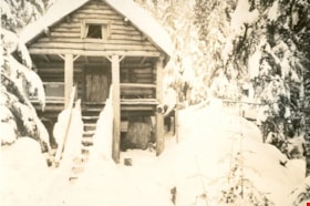
"Argu-In" cabin on Mount Seymour
https://search.heritageburnaby.ca/link/museumdescription2936
- Repository
- Burnaby Village Museum
- Date
- [between 1939 and 1949] (date of orignals), copied 2008
- Collection/Fonds
- Pixie McGeachie fonds
- Description Level
- Item
- Physical Description
- 1 photograph (tiff) : b&w ; 600 dpi
- Scope and Content
- Photograph of Jack and Pixie McGeachie's snow covered log cabin "Argu-In" looking down slope, through the trees on Mount Seymour, North Vancouver. Jack McGeachie and friends, Maurice Skinner and Jack Gannon built and maintained a cabin with friends on Mount Seymour from 1938 until after the Second…
- Repository
- Burnaby Village Museum
- Collection/Fonds
- Pixie McGeachie fonds
- Description Level
- Item
- Physical Description
- 1 photograph (tiff) : b&w ; 600 dpi
- Scope and Content
- Photograph of Jack and Pixie McGeachie's snow covered log cabin "Argu-In" looking down slope, through the trees on Mount Seymour, North Vancouver. Jack McGeachie and friends, Maurice Skinner and Jack Gannon built and maintained a cabin with friends on Mount Seymour from 1938 until after the Second World War.
- Subjects
- Natural Phenomena - Snow
- Geographic Features - Forests
- Geographic Features - Mountains - British Columbia
- Buildings - Residential - Cabins
- Accession Code
- BV008.17.25
- Access Restriction
- No restrictions
- Reproduction Restriction
- May be restricted by third party rights
- Date
- [between 1939 and 1949] (date of orignals), copied 2008
- Media Type
- Photograph
- Notes
- Title based on contents of photograph
Images


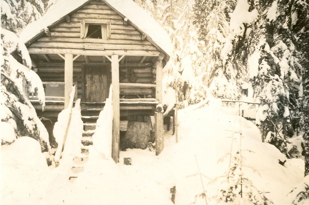
"Argu-In" on Mount Seymour
https://search.heritageburnaby.ca/link/museumdescription2923
- Repository
- Burnaby Village Museum
- Date
- [between 1939 and 1949] (date of orignals), copied 2008
- Collection/Fonds
- Pixie McGeachie fonds
- Description Level
- Item
- Physical Description
- 1 photograph (tiff) : b&w ; 600 dpi
- Scope and Content
- Photograph of Jack and Pixie McGeachie's log cabin, "Argu-In" located on Mount Seymour, North Vancouver. The cabin is surrounded by snow covered trees. Jack McGeachie and friends, Maurice Skinner and Jack Gannon built and maintained a cabin with friends on Mount Seymour from 1938 until after the …
- Repository
- Burnaby Village Museum
- Collection/Fonds
- Pixie McGeachie fonds
- Description Level
- Item
- Physical Description
- 1 photograph (tiff) : b&w ; 600 dpi
- Scope and Content
- Photograph of Jack and Pixie McGeachie's log cabin, "Argu-In" located on Mount Seymour, North Vancouver. The cabin is surrounded by snow covered trees. Jack McGeachie and friends, Maurice Skinner and Jack Gannon built and maintained a cabin with friends on Mount Seymour from 1938 until after the Second World War.
- Subjects
- Natural Phenomena - Snow
- Geographic Features - Forests
- Geographic Features - Mountains - British Columbia
- Buildings - Residential - Cabins
- Accession Code
- BV008.17.12
- Access Restriction
- No restrictions
- Reproduction Restriction
- May be restricted by third party rights
- Date
- [between 1939 and 1949] (date of orignals), copied 2008
- Media Type
- Photograph
- Notes
- Title based on contents of photograph
Images


"Argu-In" on Mount Seymour
https://search.heritageburnaby.ca/link/museumdescription2924
- Repository
- Burnaby Village Museum
- Date
- [between 1939 and 1949] (date of orignals), copied 2008
- Collection/Fonds
- Pixie McGeachie fonds
- Description Level
- Item
- Physical Description
- 1 photograph (tiff) : b&w ; 600 dpi
- Scope and Content
- Photograph of a side view of Jack and Pixie McGeachie's cabin "Argu-In" looking through snow covered trees on Mount Seymour, North Vancouver. The cabin was located on Mount Seymour.Jack McGeachie and friends, Maurice Skinner and Jack Gannon built and maintained a cabin with friends on Mount Seymou…
- Repository
- Burnaby Village Museum
- Collection/Fonds
- Pixie McGeachie fonds
- Description Level
- Item
- Physical Description
- 1 photograph (tiff) : b&w ; 600 dpi
- Scope and Content
- Photograph of a side view of Jack and Pixie McGeachie's cabin "Argu-In" looking through snow covered trees on Mount Seymour, North Vancouver. The cabin was located on Mount Seymour.Jack McGeachie and friends, Maurice Skinner and Jack Gannon built and maintained a cabin with friends on Mount Seymour from 1938 until after the Second World War.
- Subjects
- Natural Phenomena - Snow
- Geographic Features - Forests
- Geographic Features - Mountains - British Columbia
- Buildings - Residential - Cabins
- Accession Code
- BV008.17.13
- Access Restriction
- No restrictions
- Reproduction Restriction
- May be restricted by third party rights
- Date
- [between 1939 and 1949] (date of orignals), copied 2008
- Media Type
- Photograph
- Notes
- Title based on contents of photograph
Images


"Argu-In" on Mount Seymour
https://search.heritageburnaby.ca/link/museumdescription2925
- Repository
- Burnaby Village Museum
- Date
- [between 1939 and 1949] (date of orignals), copied 2008
- Collection/Fonds
- Pixie McGeachie fonds
- Description Level
- Item
- Physical Description
- 1 photograph (tiff) : b&w ; 600 dpi
- Scope and Content
- Photograph of a side view of Jack and Pixie McGeachie's log cabin "Argu-In" on Mount Seymour, North Vancouver. There is a bit of snow on the ground and smoke coming from the chimney. Jack McGeachie and friends, Maurice Skinner and Jack Gannon built and maintained a cabin with friends on Mount Seym…
- Repository
- Burnaby Village Museum
- Collection/Fonds
- Pixie McGeachie fonds
- Description Level
- Item
- Physical Description
- 1 photograph (tiff) : b&w ; 600 dpi
- Scope and Content
- Photograph of a side view of Jack and Pixie McGeachie's log cabin "Argu-In" on Mount Seymour, North Vancouver. There is a bit of snow on the ground and smoke coming from the chimney. Jack McGeachie and friends, Maurice Skinner and Jack Gannon built and maintained a cabin with friends on Mount Seymour from 1938 until after the Second World War.
- Subjects
- Natural Phenomena - Snow
- Geographic Features - Forests
- Geographic Features - Mountains - British Columbia
- Buildings - Residential - Cabins
- Accession Code
- BV008.17.14
- Access Restriction
- No restrictions
- Reproduction Restriction
- May be restricted by third party rights
- Date
- [between 1939 and 1949] (date of orignals), copied 2008
- Media Type
- Photograph
- Notes
- Title based on contents of photograph
Images

"Argu-In" on Mount Seymour
https://search.heritageburnaby.ca/link/museumdescription2937
- Repository
- Burnaby Village Museum
- Date
- [between 1939 and 1949] (date of orignals), copied 2008
- Collection/Fonds
- Pixie McGeachie fonds
- Description Level
- Item
- Physical Description
- 1 photograph (tiff) : b&w ; 600 dpi
- Scope and Content
- Photograph of Jack and Pixie McGeachie's of log cabin "Argu-In" surrounded by large drifts of snow. The cabin is located on Mount Seymour, North Vancouver. Jack McGeachie and friends, Maurice Skinner and Jack Gannon built and maintained a cabin with friends on Mount Seymour from 1938 until after th…
- Repository
- Burnaby Village Museum
- Collection/Fonds
- Pixie McGeachie fonds
- Description Level
- Item
- Physical Description
- 1 photograph (tiff) : b&w ; 600 dpi
- Scope and Content
- Photograph of Jack and Pixie McGeachie's of log cabin "Argu-In" surrounded by large drifts of snow. The cabin is located on Mount Seymour, North Vancouver. Jack McGeachie and friends, Maurice Skinner and Jack Gannon built and maintained a cabin with friends on Mount Seymour from 1938 until after the Second World War.
- Subjects
- Natural Phenomena - Snow
- Geographic Features - Forests
- Geographic Features - Mountains - British Columbia
- Buildings - Residential - Cabins
- Accession Code
- BV008.17.26
- Access Restriction
- No restrictions
- Reproduction Restriction
- May be restricted by third party rights
- Date
- [between 1939 and 1949] (date of orignals), copied 2008
- Media Type
- Photograph
- Notes
- Title based on contents of photograph
Images
![ARJ and HJ at Lunch, [1925] thumbnail](/media/hpo/_Data/_Archives_Images/_Unrestricted/001/020-128.jpg?width=280)
ARJ and HJ at Lunch
https://search.heritageburnaby.ca/link/archivedescription34421
- Repository
- City of Burnaby Archives
- Date
- [1925]
- Collection/Fonds
- Burnaby Historical Society fonds
- Description Level
- Item
- Physical Description
- 1 photograph : b&w ; 7 x 12 cm on page 17.5 x 26.5 cm
- Scope and Content
- Photograph of two men sitting beside a campfire. A pot is suspended by wooden pole over the hot coals. A caption accompanying the photograph reads: "A.R.J. [and] H.J. - Lunch." The men are only identified by their initials. This photograph appears to have been taken by Arthur Peers, who travell…
- Repository
- City of Burnaby Archives
- Date
- [1925]
- Collection/Fonds
- Burnaby Historical Society fonds
- Subseries
- Peers family subseries
- Physical Description
- 1 photograph : b&w ; 7 x 12 cm on page 17.5 x 26.5 cm
- Description Level
- Item
- Record No.
- 020-128
- Access Restriction
- No restrictions
- Reproduction Restriction
- No restrictions
- Accession Number
- BHS2007-04
- Scope and Content
- Photograph of two men sitting beside a campfire. A pot is suspended by wooden pole over the hot coals. A caption accompanying the photograph reads: "A.R.J. [and] H.J. - Lunch." The men are only identified by their initials. This photograph appears to have been taken by Arthur Peers, who travelled through the Fraser River Valley and worked on the construction of the Trans-Provincial Highway during the later 1920s.
- Media Type
- Photograph
- Photographer
- Peers, Arthur Francis "Mike"
- Notes
- Title based on caption accompanying photograph
Images
![ARJ and HJ at Lunch, [1925] thumbnail](/media/hpo/_Data/_Archives_Images/_Unrestricted/001/020-128.jpg)
![At MacMillan's Chicken Farm, [1915] thumbnail](/media/hpo/_Data/_BVM_Images/1985/1985_5818_0001_001.jpg?width=280)
At MacMillan's Chicken Farm
https://search.heritageburnaby.ca/link/museumdescription1443
- Repository
- Burnaby Village Museum
- Date
- [1915]
- Collection/Fonds
- Burnaby Village Museum Photograph collection
- Description Level
- Item
- Physical Description
- 1 photograph : b&w
- Scope and Content
- Photograph of an unidentified man sitting on grass and feeding baby chicks from his hand. There is an inverted wooden box behind the chicks that has the name "EDWARDSBURG STARCH" printed on the side. In the background are a chicken wire fence, two barrels, and a shed. The inscription on the photogr…
- Repository
- Burnaby Village Museum
- Collection/Fonds
- Burnaby Village Museum Photograph collection
- Description Level
- Item
- Physical Description
- 1 photograph : b&w
- Material Details
- inscribed in black ink, verso, t. "At MacMillan's/ Chicken Farm"
- Scope and Content
- Photograph of an unidentified man sitting on grass and feeding baby chicks from his hand. There is an inverted wooden box behind the chicks that has the name "EDWARDSBURG STARCH" printed on the side. In the background are a chicken wire fence, two barrels, and a shed. The inscription on the photograph identifies the location as "MacMillan's Chicken Farm". Further location or information about the farm is not known.
- Subjects
- Animals - Poultry
- Agriculture - Farms
- Accession Code
- BV985.5818.1
- Access Restriction
- No restrictions
- Reproduction Restriction
- No known restrictions
- Date
- [1915]
- Media Type
- Photograph
- Scan Resolution
- 600
- Scan Date
- 2024-02-27
Images
![At MacMillan's Chicken Farm, [1915] thumbnail](/media/hpo/_Data/_BVM_Images/1985/1985_5818_0001_001.jpg)

Barn at 6861 Kitchener Street
https://search.heritageburnaby.ca/link/archivedescription78995
- Repository
- City of Burnaby Archives
- Date
- October 4, 1976
- Collection/Fonds
- Burnaby Public Library Contemporary Visual Archive Project
- Description Level
- Item
- Physical Description
- 1 photograph : b&w ; 11 x 16 cm mounted on cardboard
- Scope and Content
- Photograph shows a barn and lot with a horse grazing at 6861 Kitchener Street near Cliff Avenue.
- Repository
- City of Burnaby Archives
- Date
- October 4, 1976
- Collection/Fonds
- Burnaby Public Library Contemporary Visual Archive Project
- Physical Description
- 1 photograph : b&w ; 11 x 16 cm mounted on cardboard
- Description Level
- Item
- Record No.
- 556-079
- Access Restriction
- No restrictions
- Reproduction Restriction
- Reproduce for fair dealing purposes only
- Accession Number
- 2013-13
- Scope and Content
- Photograph shows a barn and lot with a horse grazing at 6861 Kitchener Street near Cliff Avenue.
- Media Type
- Photograph
- Photographer
- Born, A. J.
- Notes
- Scope note taken directly from BPL photograph description.
- 1 b&w copy negative : 10 x 12.5 cm accompanying
- Geographic Access
- Kitchener Street
- Street Address
- 6861 Kitchener Street
- Historic Neighbourhood
- Lochdale (Historic Neighbourhood)
- Planning Study Area
- Lochdale Area
Images


Barn, paddock and out buildings
https://search.heritageburnaby.ca/link/museumdescription12818
- Repository
- Burnaby Village Museum
- Date
- 1977
- Collection/Fonds
- Century Park Museum Association fonds
- Description Level
- Item
- Physical Description
- 1 photograph : col. slide ; 35 mm
- Scope and Content
- Photograph of the barn, fenced paddocks and out buildings on the Lubbock family farm located at 7803 Burris Street.
- Repository
- Burnaby Village Museum
- Collection/Fonds
- Century Park Museum Association fonds
- Description Level
- Item
- Physical Description
- 1 photograph : col. slide ; 35 mm
- Scope and Content
- Photograph of the barn, fenced paddocks and out buildings on the Lubbock family farm located at 7803 Burris Street.
- History
- In 1977, Century Park Museum was granted access to the Sprott-Lubbock farm to appraise the heritage buildings for preservation. Buildings that were saved included the old farrier shed (BV985.1240.2) which was also used as a blacksmith shop and the Vorce tram station building (BV985.1240.3) from the old Burnaby Lake Interurban line which was used as a grain storage shed on the property. Segments of the original farmhouse and other out buildings were retained. Other buildings on the site were demolished to make way for a new housing development.
- Subjects
- Agriculture - Farms
- Names
- Lubbock farm
- Geographic Access
- Grandview Highway
- Burris Street
- Street Address
- 7803 Burris Street
- Accession Code
- BV020.5.485
- Access Restriction
- No restrictions
- Reproduction Restriction
- No known restrictions
- Date
- 1977
- Media Type
- Photograph
- Historic Neighbourhood
- Burnaby Lake (Historic Neighbourhood)
- Planning Study Area
- Morley-Buckingham Area
- Scan Resolution
- 2400
- Scan Date
- 13-Mar-20
- Scale
- 100
- Notes
- Title based on contents of photograph
Images

![Barns at Oakalla, [195-] (date of original), copied 1991 thumbnail](/media/hpo/_Data/_Archives_Images/_Unrestricted/370/370-706.jpg?width=280)
Barns at Oakalla
https://search.heritageburnaby.ca/link/archivedescription38119
- Repository
- City of Burnaby Archives
- Date
- [195-] (date of original), copied 1991
- Collection/Fonds
- Burnaby Historical Society fonds
- Description Level
- Item
- Physical Description
- 1 photograph : b&w ; 2.8 x 4.1 cm print on contact sheet 20.1 x 26.5 cm
- Scope and Content
- Photograph of the exterior of horse and cattle barns at Oakalla Prison Farm.
- Repository
- City of Burnaby Archives
- Date
- [195-] (date of original), copied 1991
- Collection/Fonds
- Burnaby Historical Society fonds
- Subseries
- Burnaby Image Bank subseries
- Physical Description
- 1 photograph : b&w ; 2.8 x 4.1 cm print on contact sheet 20.1 x 26.5 cm
- Description Level
- Item
- Record No.
- 370-706
- Access Restriction
- No restrictions
- Reproduction Restriction
- Reproduce for fair dealing purposes only
- Accession Number
- BHS1999-03
- Scope and Content
- Photograph of the exterior of horse and cattle barns at Oakalla Prison Farm.
- Subjects
- Buildings - Agricultural - Barns
- Agriculture - Farms
- Buildings - Public - Detention Facilities
- Names
- Oakalla Prison Farm
- Media Type
- Photograph
- Notes
- Title based on contents of photograph
- 1 b&w copy negative accompanying
- Negative has a pink cast
- Geographic Access
- Oakmount Crescent
- Street Address
- 5220 Oakmount Crescent
- Historic Neighbourhood
- Burnaby Lake (Historic Neighbourhood)
- Planning Study Area
- Oakalla Area
Images
![Barns at Oakalla, [195-] (date of original), copied 1991 thumbnail](/media/hpo/_Data/_Archives_Images/_Unrestricted/370/370-706.jpg)