Narrow Results By
![Archie and Dale in a cemetery, [2000] thumbnail](/media/hpo/_Data/_Archives_Images/_Unrestricted/535/535-2709-1.jpg?width=280)
Archie and Dale in a cemetery
https://search.heritageburnaby.ca/link/archivedescription97313
- Repository
- City of Burnaby Archives
- Date
- [2000]
- Collection/Fonds
- Burnaby NewsLeader photograph collection
- Description Level
- File
- Physical Description
- 4 photographs (tiff) : col.
- Scope and Content
- File contains photographs of two people, identified as Archie and Dale, in a cemetery. Photographs depict Archie and Dale looking at or posing with headstones and a close-up of an individual headstone.
- Repository
- City of Burnaby Archives
- Date
- [2000]
- Collection/Fonds
- Burnaby NewsLeader photograph collection
- Physical Description
- 4 photographs (tiff) : col.
- Description Level
- File
- Record No.
- 535-2709
- Access Restriction
- No restrictions
- Reproduction Restriction
- No restrictions
- Accession Number
- 2018-12
- Scope and Content
- File contains photographs of two people, identified as Archie and Dale, in a cemetery. Photographs depict Archie and Dale looking at or posing with headstones and a close-up of an individual headstone.
- Subjects
- Cemeteries
- Monuments - Gravestones
- Media Type
- Photograph
- Notes
- Title based on contents of file
- Collected by editorial for use in a September 2000 issue of the Burnaby NewsLeader
- Individuals identified by original file names of photographs
Images
![Archie and Dale in a cemetery, [2000] thumbnail](/media/hpo/_Data/_Archives_Images/_Unrestricted/535/535-2709-1.jpg)
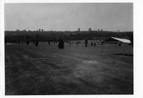
Forest Lawn Cemetery
https://search.heritageburnaby.ca/link/archivedescription93709
- Repository
- City of Burnaby Archives
- Date
- June 4, 1978
- Collection/Fonds
- Burnaby Public Library Contemporary Visual Archive Project
- Description Level
- Item
- Physical Description
- 1 photograph : b&w ; 12.5 x 17.5 cm
- Scope and Content
- Photograph of the grounds of the Forest Lawn Memorial Park cemetery, located by Royal Oak Avenue and Canada Way. Shrubs, gravestones, and a tent are across the lawn. The photograph is taken from on the grounds, facing south. High-rise buildings in the Metrotown area are visible in the distance.
- Repository
- City of Burnaby Archives
- Date
- June 4, 1978
- Collection/Fonds
- Burnaby Public Library Contemporary Visual Archive Project
- Physical Description
- 1 photograph : b&w ; 12.5 x 17.5 cm
- Description Level
- Item
- Record No.
- 556-666
- Access Restriction
- No restrictions
- Reproduction Restriction
- Reproduce for fair dealing purposes only
- Accession Number
- 2017-57
- Scope and Content
- Photograph of the grounds of the Forest Lawn Memorial Park cemetery, located by Royal Oak Avenue and Canada Way. Shrubs, gravestones, and a tent are across the lawn. The photograph is taken from on the grounds, facing south. High-rise buildings in the Metrotown area are visible in the distance.
- Subjects
- Monuments - Gravestones
- Cemeteries
- Media Type
- Photograph
- Photographer
- Surridge, Jack
- Notes
- Title taken from project information form
- Accompanied by a project information form and 1 photograph (b&w negative ; 9.5 x 12.5 cm)
- BPL no. 113
- Geographic Access
- Royal Oak Avenue
- Street Address
- 3789 Royal Oak Avenue
- Historic Neighbourhood
- Burnaby Lake (Historic Neighbourhood)
- Planning Study Area
- Douglas-Gilpin Area
Images

![Burnaby family gravestones, [194-] thumbnail](/media/hpo/_Data/_BVM_Images/1976/1976_0065_0003_001.jpg?width=280)
Burnaby family gravestones
https://search.heritageburnaby.ca/link/museumdescription745
- Repository
- Burnaby Village Museum
- Date
- [194-]
- Collection/Fonds
- Burnaby Village Museum Photograph collection
- Description Level
- Item
- Physical Description
- 1 photograph : b&w ; 11.4 x 8.9 cm
- Scope and Content
- Photograph of the grave marker for Robert Burnaby and other family members in cemetery in Loughborough, United Kingdom. The grave marker is a cross on three tiered slabs with plaque on each. The top one reads, "Robert Burnaby / Born Nov. 30. 1828: Died Jan. 10.1878." The middle one reads, "Sarah…
- Repository
- Burnaby Village Museum
- Collection/Fonds
- Burnaby Village Museum Photograph collection
- Description Level
- Item
- Physical Description
- 1 photograph : b&w ; 11.4 x 8.9 cm
- Scope and Content
- Photograph of the grave marker for Robert Burnaby and other family members in cemetery in Loughborough, United Kingdom. The grave marker is a cross on three tiered slabs with plaque on each. The top one reads, "Robert Burnaby / Born Nov. 30. 1828: Died Jan. 10.1878." The middle one reads, "Sarah Burnaby / Born October 22. 1822: Died March 2 1875./ Rev. VII. 14." The bottom one reads, "Sarah, Widow of the / Rev. Thomas Burnaby, / And mother of the above. / Died: Oct. 31, 1878, Aged 80 Years." It is suspected that the grave marker was located in the large church building that is shown in photo HV976.65.1. There is a brick wall behind the grave marker. Stamped on the back of the photo: "4387."
- Subjects
- Monuments - Gravestones
- Accession Code
- HV976.65.3
- Access Restriction
- No restrictions
- Reproduction Restriction
- No known restrictions
- Date
- [194-]
- Media Type
- Photograph
- Related Material
- For a closer view of the grave marker, see HV976.65.2
- Scan Resolution
- 600
- Scan Date
- 2023-06-20
- Notes
- Title based on contents of photograph
- 1 b&w copy negative accompanying
Images
![Burnaby family gravestones, [194-] thumbnail](/media/hpo/_Data/_BVM_Images/1976/1976_0065_0003_001.jpg)
![Church, [194-] thumbnail](/media/hpo/_Data/_BVM_Images/1976/1976_0065_0001_001.jpg?width=280)
Church
https://search.heritageburnaby.ca/link/museumdescription743
- Repository
- Burnaby Village Museum
- Date
- [194-]
- Collection/Fonds
- Burnaby Village Museum Photograph collection
- Description Level
- Item
- Physical Description
- 1 photograph : b&w ; 8.9 x 11.3 cm
- Scope and Content
- Photograph of a large church building that has been conjectured in the accession register to be the church (or the cemetery) in which Robert Burnaby was buried. Following that logic, this would be in Loughborough, where Robert Burnaby is buried. Stamped on the back of the photo: "4387."
- Repository
- Burnaby Village Museum
- Collection/Fonds
- Burnaby Village Museum Photograph collection
- Description Level
- Item
- Physical Description
- 1 photograph : b&w ; 8.9 x 11.3 cm
- Scope and Content
- Photograph of a large church building that has been conjectured in the accession register to be the church (or the cemetery) in which Robert Burnaby was buried. Following that logic, this would be in Loughborough, where Robert Burnaby is buried. Stamped on the back of the photo: "4387."
- Subjects
- Buildings - Religious - Churches
- Accession Code
- HV976.65.1
- Access Restriction
- No restrictions
- Reproduction Restriction
- May be restricted by third party rights
- Date
- [194-]
- Media Type
- Photograph
- Scan Resolution
- 600
- Scan Date
- 2023-06-20
- Notes
- Title based on contents of photograph
- 1 b&w copy negative accompanying
Images
![Church, [194-] thumbnail](/media/hpo/_Data/_BVM_Images/1976/1976_0065_0001_001.jpg)

First United Spiritualist Church
https://search.heritageburnaby.ca/link/archivedescription79041
- Repository
- City of Burnaby Archives
- Date
- October, 1976
- Collection/Fonds
- Burnaby Public Library Contemporary Visual Archive Project
- Description Level
- Item
- Physical Description
- 1 photograph : b&w ; 11 x 16 cm mounted on cardboard
- Scope and Content
- Photograph shows the First United Spiritualist Church located at 5584 Kincaid Street. This structure was originally built on the triangle across from Forest Lawn Cemetery at Royal Oak Avenue and Canada Way to serve as the funeral parlor for Forest Lawn. In 1955 it was moved to the Kincaid address…
- Repository
- City of Burnaby Archives
- Date
- October, 1976
- Collection/Fonds
- Burnaby Public Library Contemporary Visual Archive Project
- Physical Description
- 1 photograph : b&w ; 11 x 16 cm mounted on cardboard
- Description Level
- Item
- Record No.
- 556-109
- Access Restriction
- No restrictions
- Reproduction Restriction
- Reproduce for fair dealing purposes only
- Accession Number
- 2013-13
- Scope and Content
- Photograph shows the First United Spiritualist Church located at 5584 Kincaid Street. This structure was originally built on the triangle across from Forest Lawn Cemetery at Royal Oak Avenue and Canada Way to serve as the funeral parlor for Forest Lawn. In 1955 it was moved to the Kincaid address and occupied by the St. Columba Anglican Church which was vacated in December 1970. In April 1971, the First United Spiritualist Church moved in.
- Subjects
- Buildings - Religious - Churches
- Media Type
- Photograph
- Photographer
- Salmon, Stu
- Notes
- Scope note taken directly from BPL photograph description.
- 1 b&w copy negative : 10 x 12.5 cm accompanying
- Geographic Access
- Kincaid Street
- Street Address
- 5584 Kincaid Street
- Planning Study Area
- Douglas-Gilpin Area
Images
