Narrow Results By
Creator
- Adams, John 2
- Aitkenhead, May 1
- Armstrong, Sophie 1
- Beach, Chris 1
- Bekins Moving and Storage Company Limited 1
- Bowman, Carly 1
- British Columbia Underwriters' Association 10
- Burnett and McGugan B.C. Land Surveyors, New Westminster 5
- Burnett, David H. 1
- Burnett, Geoffrey K. 6
- Burnett & McGugan, Engineers and Surveyors 23
- City Map and White Print Co. 1
Person / Organization
- All Saints Anglican Church 1
- Armstrong Avenue School 1
- Atcheson, Jean 1
- Barnet School 1
- Bellinger, Marion 1
- British Columbia Electric Railway Company 1
- Broadview Presbyterian Church 1
- Brownlee, James Harrison 1
- Burnaby Village Museum 3
- Burnett, Geoffrey K. 2
- Ceperley, H.T. 2
- Chinese Market Gardens 1
![Oakalla Prison Farm, [2019] thumbnail](/media/hpo/_Data/_BVM_Images/2019/2019_0036_0001_001.jpg?width=280)
Oakalla Prison Farm
https://search.heritageburnaby.ca/link/museumdescription18849
- Repository
- Burnaby Village Museum
- Date
- [2019]
- Collection/Fonds
- Burnaby Village Museum fonds
- Description Level
- Item
- Physical Description
- 1 painting (tiff)
- Scope and Content
- Item consists of a digital copy of a painting of a view of Oakalla Prison farm with Deer Lake in the background. The original painting was created by Burnaby Village Museum preparator Carly Bowman as part of an exhibit.
- Repository
- Burnaby Village Museum
- Collection/Fonds
- Burnaby Village Museum fonds
- Series
- Museum exhibits series
- Subseries
- Museum materials for exhibits subseries
- Description Level
- Item
- Physical Description
- 1 painting (tiff)
- Scope and Content
- Item consists of a digital copy of a painting of a view of Oakalla Prison farm with Deer Lake in the background. The original painting was created by Burnaby Village Museum preparator Carly Bowman as part of an exhibit.
- Creator
- Bowman, Carly
- Names
- Oakalla Prison Farm
- Accession Code
- BV019.36.1
- Date
- [2019]
- Media Type
- Graphic Material
- Notes
- Title based on contents of item
Images
![Oakalla Prison Farm, [2019] thumbnail](/media/hpo/_Data/_BVM_Images/2019/2019_0036_0001_001.jpg)

Okanagan Fishing Guide
https://search.heritageburnaby.ca/link/museumdescription11398
- Repository
- Burnaby Village Museum
- Date
- 1948
- Collection/Fonds
- Burnaby Village Museum Map collection
- Description Level
- Item
- Physical Description
- 1 map : col. ink on paper handcol. ; 24 x 35 cm
- Scope and Content
- Item consists of map titled "Okanagan Fishing Guide / Showing / Major Roads / and the / Best Fish Lakes". Hand drawn map compiled and drawn by W.C. Rueber, Kelowna B.C. of Okanagan Lake area. Advertisement at bottom of page indicates that it may have been produced by "OK USED FURNITURE STORE / 239 …
- Repository
- Burnaby Village Museum
- Collection/Fonds
- Burnaby Village Museum Map collection
- Description Level
- Item
- Physical Description
- 1 map : col. ink on paper handcol. ; 24 x 35 cm
- Scope and Content
- Item consists of map titled "Okanagan Fishing Guide / Showing / Major Roads / and the / Best Fish Lakes". Hand drawn map compiled and drawn by W.C. Rueber, Kelowna B.C. of Okanagan Lake area. Advertisement at bottom of page indicates that it may have been produced by "OK USED FURNITURE STORE / 239 BERNARD AVE., KELOWNA, B.C....". The map was copyrighted in Canada on July 20, 1948, No. 79416.
- Creator
- Rueber, W.C.
- Publisher
- OK Used Furniture Store
- Accession Code
- BV006.24.116
- Access Restriction
- No restrictions
- Reproduction Restriction
- May be restricted by third party rights
- Date
- 1948
- Media Type
- Cartographic Material
- Scan Resolution
- 600
- Scan Date
- 2021-11-23
- Notes
- Transcribed title
- Staining on map with creases from being folded and handcoloured markings with blue pencil
Images

![Pages from May Aikenhead scrapbook, [1930-1935] thumbnail](/media/hpo/_Data/_BVM_Images/2015/2015_0035_0168_all_pages.jpg?width=280)
Pages from May Aikenhead scrapbook
https://search.heritageburnaby.ca/link/museumdescription5245
- Repository
- Burnaby Village Museum
- Date
- [1930-1935]
- Collection/Fonds
- Burnaby Girl Guides fonds
- Description Level
- File
- Physical Description
- 1 file of textual records : 1 p. + 1 illustration : col. ; graphite and watercolour + 1 digital file : col. (pdf) + 10 photographs : col. (tiffs)
- Scope and Content
- File consists of pages from a scrapbook created by May Aitkenhead. Pages include an illustration of a Girl Guide in uniform done in pencil and watercolour along with two pages (double sided) of clippings from newspapers, magazines and a programme. The illustration page includes the name "Mabel McIn…
- Repository
- Burnaby Village Museum
- Collection/Fonds
- Burnaby Girl Guides fonds
- Description Level
- File
- Physical Description
- 1 file of textual records : 1 p. + 1 illustration : col. ; graphite and watercolour + 1 digital file : col. (pdf) + 10 photographs : col. (tiffs)
- Scope and Content
- File consists of pages from a scrapbook created by May Aitkenhead. Pages include an illustration of a Girl Guide in uniform done in pencil and watercolour along with two pages (double sided) of clippings from newspapers, magazines and a programme. The illustration page includes the name "Mabel McIntyre / Cl. 16" handwritten in pencil at the top of the page along with a sticker of a wreath. The newspaper clippings page is titled "Guide News" and includes selected clippings about the 5th Burnaby Girl Guides, while two other pages include information titled "Patrol Portfolio Chart No. 9 _ Digging"; "The Aims of the Girl Guides" and "Girl Guiding" with photographic images of Mrs. Alan Morkill (Provincial Commissioner for British Columbia); Countess Bessborough (Honourary President of the Canadian Girl Guide Association); His Excellency Rt. Hon. the Earl of Bessborough (Governor General and Commander in Chief of the Dominion of Canada- Chief Scout of Canada) as well as Lady and Lord Baden Powell. The last page is clipped and pasted from a programme and/or poster "Grand Rally / Scouts / and / Guides / April 15th 1935 / Hastings Park / Vancouver BC" and includes a page of the programme.
- Creator
- Aitkenhead, May
- Names
- Girl Guides of Canada
- Accession Code
- BV015.35.168
- Access Restriction
- No restrictions
- Reproduction Restriction
- May be restricted by third party rights
- Date
- [1930-1935]
- Media Type
- Textual Record
- Graphic Material
- Notes
- Title based on contents of file
- Digital images were created of the scrapbook prior to selective retention of original records
- Selected pages were removed from original scrapbook and were retained under BV015.35.168
- Selected photographs were removed from scrapbook prior and are described at item level (BV015.35.292 to BV015.35.300)
Images
![Pages from May Aikenhead scrapbook, [1930-1935] thumbnail](/media/hpo/_Data/_BVM_Images/2015/2015_0035_0168_all_pages.jpg)
Documents
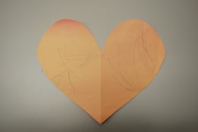
Paper heart by Sophie Armstrong
https://search.heritageburnaby.ca/link/museumdescription14749
- Repository
- Burnaby Village Museum
- Date
- March 2020
- Collection/Fonds
- Burnaby Village Museum COVID-19 collection
- Description Level
- Item
- Physical Description
- 1 drawing : wax crayon on pink construction paper ; 20 x 23.5 cm
- Scope and Content
- Item consists of a heart that has been cut out of pink coloured construction paper. One side of the heart has contains a child's drawing with markings in purple crayon while the other side is blank. The side with the markings is faded from exposure due to sunlight after being hung in a window.
- Repository
- Burnaby Village Museum
- Collection/Fonds
- Burnaby Village Museum COVID-19 collection
- Description Level
- Item
- Physical Description
- 1 drawing : wax crayon on pink construction paper ; 20 x 23.5 cm
- Scope and Content
- Item consists of a heart that has been cut out of pink coloured construction paper. One side of the heart has contains a child's drawing with markings in purple crayon while the other side is blank. The side with the markings is faded from exposure due to sunlight after being hung in a window.
- History
- This was a heart the Armstrong family made in the last week of March when things were starting to get very scary and they wanted to share their message of love and support to the world. The heart was decorated on one side by Sophie (age 1), Kimberly's youngest daughter (of two). The heart remained on the window until mid July 2020.
- Creator
- Armstrong, Sophie
- Subjects
- Arts - Drawings
- Crafts
- Pandemics - COVID-19
- Responsibility
- Paneloc Marketing Limited
- Accession Code
- BV020.24.1
- Access Restriction
- No restrictions
- Reproduction Restriction
- No known restrictions
- Date
- March 2020
- Media Type
- Graphic Material
- Notes
- Title based on contents of item
Images


Part of the New Westminster District shewing the Proposed New Municipality of Burnaby
https://search.heritageburnaby.ca/link/museumdescription17544
- Repository
- Burnaby Village Museum
- Date
- 1891 (date of original)
- Collection/Fonds
- Burnaby Village Museum Map collection
- Description Level
- Item
- Physical Description
- 1 map : blueline print with col. ; 59 x 96 cm
- Scope and Content
- Item consists of a map titled "Part of the New Westminster District shewing the Proposed New Municipality of Burnaby". The map shows boundaries of a proposed new municipality of Burnaby including all land outside of the "old" City of Vancouver between Burrard Inlet and the Fraser River and west of …
- Repository
- Burnaby Village Museum
- Collection/Fonds
- Burnaby Village Museum Map collection
- Description Level
- Item
- Physical Description
- 1 map : blueline print with col. ; 59 x 96 cm
- Material Details
- Scale approx. [1:31,680]
- Scope and Content
- Item consists of a map titled "Part of the New Westminster District shewing the Proposed New Municipality of Burnaby". The map shows boundaries of a proposed new municipality of Burnaby including all land outside of the "old" City of Vancouver between Burrard Inlet and the Fraser River and west of North Road. Map also shows the boundaries of the District Lots. Signed by Garden, Hermon and Burwell Provincial Land Surveyors, Vancouver, June 5, 1891. Blueline print is hand-coloured highlighting Burnaby.
- Creator
- Garden, Hermon and Burwell
- Accession Code
- BV994.29.1
- Access Restriction
- No restrictions
- Reproduction Restriction
- No known restrictions
- Date
- 1891 (date of original)
- Media Type
- Cartographic Material
- Scan Resolution
- 300
- Scan Date
- 2022-05-10
- Notes
- Transcribed title
Images

![Planning Map of Chinese Market Gardens on Marine Drive, [between 1950 and 1959] (date of original), 2017 (date of duplication) thumbnail](/media/hpo/_Data/_BVM_Images/2017/2017_0040_0002_001.jpg?width=280)
Planning Map of Chinese Market Gardens on Marine Drive
https://search.heritageburnaby.ca/link/museumdescription4297
- Repository
- Burnaby Village Museum
- Date
- [between 1950 and 1959] (date of original), 2017 (date of duplication)
- Collection/Fonds
- Herbert Yee Law family fonds
- Description Level
- Item
- Physical Description
- 1 photograph (tiff) : col. ; 300 dpi
- Scope and Content
- Scanned copy of a survey plan of district lots 163, 162, 157, 158, and 165, near the Chinese Market Gardens along Marine Drive.
- Repository
- Burnaby Village Museum
- Collection/Fonds
- Herbert Yee Law family fonds
- Description Level
- Item
- Physical Description
- 1 photograph (tiff) : col. ; 300 dpi
- Scope and Content
- Scanned copy of a survey plan of district lots 163, 162, 157, 158, and 165, near the Chinese Market Gardens along Marine Drive.
- History
- Survey plan of district lots 163, 162, 157, 158, and 165, which is primarily the area farmed by Chinese and Chinese-Canadian market gardeners around Marine Drive between Royal Oak and Mandeville (present-day Nelson). Two Chinese/Chinese Canadian land owners can be seen on the map: N.G. Wah Sing (or Ng Wah Sing) and Yee Law (or Herbert Law).
- Geographic Access
- Marine Drive
- Accession Code
- BV017.40.2
- Access Restriction
- No restrictions
- Reproduction Restriction
- No known restrictions
- Date
- [between 1950 and 1959] (date of original), 2017 (date of duplication)
- Media Type
- Cartographic Material
- Historic Neighbourhood
- Fraser Arm (Historic Neighbourhood)
- Planning Study Area
- Big Bend Area
- Scan Resolution
- 300
- Scan Date
- 11/19/2017
- Scale
- 100
- Notes
- Title based on contents of copy scan of map
- Herbert Yee Law was donor's father and this map may have originally been his copy of the city planning/engineering documents.
Images
![Planning Map of Chinese Market Gardens on Marine Drive, [between 1950 and 1959] (date of original), 2017 (date of duplication) thumbnail](/media/hpo/_Data/_BVM_Images/2017/2017_0040_0002_001.jpg)

Plan of Subdivision of Block F Lot 1, D.L. 25 Group 1
https://search.heritageburnaby.ca/link/museumdescription18808
- Repository
- Burnaby Village Museum
- Date
- 17 Apr. 1912
- Collection/Fonds
- Love family fonds
- Description Level
- Item
- Physical Description
- 1 plan : black and red ink on linen ; 36 x 28.5 cm
- Scope and Content
- Item consists of Plan of Subdivision of Block F Lot 1, D.L. 25 Group 1 New Westminster District created by Provincial Land Surveyor Geoffrey K. Burnett.
- Repository
- Burnaby Village Museum
- Collection/Fonds
- Love family fonds
- Description Level
- Item
- Physical Description
- 1 plan : black and red ink on linen ; 36 x 28.5 cm
- Material Details
- Scale [1:1200]
- Scope and Content
- Item consists of Plan of Subdivision of Block F Lot 1, D.L. 25 Group 1 New Westminster District created by Provincial Land Surveyor Geoffrey K. Burnett.
- Creator
- Burnett, Geoffrey K.
- Names
- Burnett, Geoffrey K.
- Geographic Access
- Cumberland Street
- Accession Code
- BV992.26.28
- Access Restriction
- No restrictions
- Reproduction Restriction
- No known restrictions
- Date
- 17 Apr. 1912
- Media Type
- Cartographic Material
- Historic Neighbourhood
- East Burnaby (Historic Neighbourhood)
- Planning Study Area
- Cariboo-Armstrong Area
- Scan Resolution
- 600
- Scan Date
- 2022-07-11
- Scale
- 100
- Notes
- Title based on contents of item
- Scale is measured "100 FT = 1 INCH"
- "PLAN OF SUBDIVISION OF BLOCK "F" OF LOT 1, D.L. 25 GROUP 1. NEW WESTMINSTER DISTRICT"; Wright St., Sixth Ave., Fifth Ave., Cumberland St., L.1-8, 11-16; signature of Jesse Love, owner, witness S.P. King?; Geoffrey K. Burnett, P.L.S.; Fred A. Macpherson, Municipal Clerk, April 17, 1912; taxes paid to Dec. 31 1911, signed April 17 1912 by W.H. Griffin, collector"
Images


Plan of Subdivision of Block F Lot 1, D.L. 25 Group 1
https://search.heritageburnaby.ca/link/museumdescription18809
- Repository
- Burnaby Village Museum
- Date
- 17 Apr. 1912
- Collection/Fonds
- Love family fonds
- Description Level
- Item
- Physical Description
- 1 plan : black and red ink on linen ; 36 x 28.5 cm
- Scope and Content
- Item consists of Plan of Subdivision of Block F Lot 1, D.L. 25 Group 1 New Westminster District created by Provincial Land Surveyor Geoffrey K. Burnett.
- Repository
- Burnaby Village Museum
- Collection/Fonds
- Love family fonds
- Description Level
- Item
- Physical Description
- 1 plan : black and red ink on linen ; 36 x 28.5 cm
- Material Details
- Scale [1:1200]
- Scope and Content
- Item consists of Plan of Subdivision of Block F Lot 1, D.L. 25 Group 1 New Westminster District created by Provincial Land Surveyor Geoffrey K. Burnett.
- Creator
- Burnett, Geoffrey K.
- Names
- Burnett, Geoffrey K.
- Geographic Access
- Cumberland Street
- Accession Code
- BV992.26.29
- Access Restriction
- No restrictions
- Reproduction Restriction
- No known restrictions
- Date
- 17 Apr. 1912
- Media Type
- Cartographic Material
- Historic Neighbourhood
- East Burnaby (Historic Neighbourhood)
- Planning Study Area
- Cariboo-Armstrong Area
- Scan Resolution
- 600
- Scan Date
- 2022-07-11
- Scale
- 100
- Notes
- Title based on contents of item
- Scale is measured "100 FT = 1 INCH"
- "PLAN OF SUBDIVISION OF BLOCK "F" OF LOT 1, D.L. 25 GROUP 1. NEW WESTMINSTER DISTRICT"; Wright St., Sixth Ave., Fifth Ave., Cumberland St., L.1-8, 11-16; signature of Jesse Love, owner, witness S.P. King?; Geoffrey K. Burnett, P.L.S.; Fred A. Macpherson, Municipal Clerk, April 17, 1912; taxes paid to Dec. 31 1911, signed April 17 1912 by W.H. Griffin, collector"
Images

![Plan of Subdivision of Blocks 1,2.3,6,21 and 23 of District Lot 211, [between 1911 and 1912] thumbnail](/media/hpo/_Data/_BVM_Cartographic_Material/1984/1984_0057_0004_002%20Web.jpg?width=280)
Plan of Subdivision of Blocks 1,2.3,6,21 and 23 of District Lot 211
https://search.heritageburnaby.ca/link/museumdescription11111
- Repository
- Burnaby Village Museum
- Date
- [between 1911 and 1912]
- Collection/Fonds
- Ronald G. Scobbie collection
- Description Level
- Item
- Physical Description
- 1 plan : ink on waxed linen ; 60 x 52.5 cm
- Scope and Content
- Item consists of a "Plan of Subdivision of Blocks 1,2.3,6,21 and 23 / of District Lot 211. Group 1 N.W.D. / Burnaby Municipality"
- Repository
- Burnaby Village Museum
- Collection/Fonds
- Ronald G. Scobbie collection
- Description Level
- Item
- Physical Description
- 1 plan : ink on waxed linen ; 60 x 52.5 cm
- Material Details
- Scale [1:1200]
- Scope and Content
- Item consists of a "Plan of Subdivision of Blocks 1,2.3,6,21 and 23 / of District Lot 211. Group 1 N.W.D. / Burnaby Municipality"
- Creator
- Hill & Burnett
- Accession Code
- HV984.57.4
- Access Restriction
- No restrictions
- Reproduction Restriction
- No known restrictions
- Date
- [between 1911 and 1912]
- Media Type
- Cartographic Material
- Planning Study Area
- Burnaby Mountain Area
- Scan Resolution
- 400
- Scan Date
- Dec. 22, 2020
- Scale
- 100
- Notes
- Transcribed title
- Scale is measured "100 feet to one inch"
- Credit on plan reads: "Hill & Burnett_BC_Land Surveyors_Civil Engineers_New Westminster_B.C."
Zoomable Images
![Plan of Subdivision of Blocks 1,2.3,6,21 and 23 of District Lot 211, [between 1911 and 1912] thumbnail](/media/hpo/_Data/_BVM_Cartographic_Material/1984/1984_0057_0004_001_seadragon/1984_0057_0004_001.jpg?w=280)
Plan of Subdivision of Blocks 1,2.3,6,21 and 23 of District Lot 211, [between 1911 and 1912]
Zoom into Image![Plan of Subdivision of Blocks 1,2,3,6,21 and 23 of District Lot 211, [between 1911 and 1912] thumbnail](/media/hpo/_Data/_BVM_Cartographic_Material/1984/1984_0057_0005_002%20Web.jpg?width=280)
Plan of Subdivision of Blocks 1,2,3,6,21 and 23 of District Lot 211
https://search.heritageburnaby.ca/link/museumdescription11212
- Repository
- Burnaby Village Museum
- Date
- [between 1911 and 1912]
- Collection/Fonds
- Ronald G. Scobbie collection
- Description Level
- Item
- Physical Description
- 1 plan : ink on waxed linen ; 77 x 53 cm
- Scope and Content
- "Plan of Subdivision of Blks 1,2.3.6.21. and 23 / of District Lot 211, Group ;1 , N.W.D./ Burnaby Municipality"
- Repository
- Burnaby Village Museum
- Collection/Fonds
- Ronald G. Scobbie collection
- Description Level
- Item
- Physical Description
- 1 plan : ink on waxed linen ; 77 x 53 cm
- Scope and Content
- "Plan of Subdivision of Blks 1,2.3.6.21. and 23 / of District Lot 211, Group ;1 , N.W.D./ Burnaby Municipality"
- Creator
- Hill & Burnett
- Accession Code
- HV984.57.5
- Access Restriction
- No restrictions
- Reproduction Restriction
- No known restrictions
- Date
- [between 1911 and 1912]
- Media Type
- Cartographic Material
- Planning Study Area
- Burnaby Mountain Area
- Scan Resolution
- 400
- Scan Date
- Dec. 22, 2020
- Scale
- 100
- Notes
- Transcribed title
- Scale is measured "100 feet to one inch"
- Credit on plan reads: "Hill & Burnett_BC_Land Surveyors_Civil Engineers_New Westminster_B.C."
Zoomable Images
![Plan of Subdivision of Blocks 1,2,3,6,21 and 23 of District Lot 211, [between 1911 and 1912] thumbnail](/media/hpo/_Data/_BVM_Cartographic_Material/1984/1984_0057_0005_001_seadragon/1984_0057_0005_001.jpg?w=280)
Plan of Subdivision of Blocks 1,2,3,6,21 and 23 of District Lot 211, [between 1911 and 1912]
Zoom into Image
Plan of Subdivision of Lot 14 of North part of NW 1/4 of D.L. 150 GR.1 N.W.D
https://search.heritageburnaby.ca/link/museumdescription11117
- Repository
- Burnaby Village Museum
- Date
- 1912
- Collection/Fonds
- Ronald G. Scobbie collection
- Description Level
- Item
- Physical Description
- 2 plans : ink on linen + blueprint ; 21.5 x 27.5 cm
- Scope and Content
- File consists of "Plan of Subdivision of Lot 14 of North / Part of N.W. 1/4 of D.L. 150, GR.1. / N.W.D." and blueprint of same.
- Repository
- Burnaby Village Museum
- Collection/Fonds
- Ronald G. Scobbie collection
- Description Level
- Item
- Physical Description
- 2 plans : ink on linen + blueprint ; 21.5 x 27.5 cm
- Material Details
- Scale [1:1200]
- Scope and Content
- File consists of "Plan of Subdivision of Lot 14 of North / Part of N.W. 1/4 of D.L. 150, GR.1. / N.W.D." and blueprint of same.
- Creator
- Hill & Burnett
- Geographic Access
- Jubilee Avenue
- Accession Code
- HV984.57.10
- Access Restriction
- No restrictions
- Reproduction Restriction
- No known restrictions
- Date
- 1912
- Media Type
- Cartographic Material
- Planning Study Area
- Suncrest Area
- Scan Resolution
- 600
- Scan Date
- 2-Oct-19
- Scale
- 100
- Notes
- Transcribed title
- Notes in red crayon on verso of both plans read: "00079"
- Oval shaped stamp in blue ink on front of blueprint plan reads: "Corporation of Burnaby / Feb. 2 1912 / Engineering Department"
- Stamp in red ink on verso of Blueprint plan reads: "Hill & Burnett / Civil Engineers / B.C. Land Surveyors / New Westminster B.C."
- Handwritten note on front of blueprint plan reads: "T... [sic] approved / subject to 20' Laws [sic] / being given. / Fred L. Macpherson / Engineer / Feb. 6th 1912"
Images


Plan of Survey Lot A of Block 1 District Lot 42
https://search.heritageburnaby.ca/link/museumdescription18823
- Repository
- Burnaby Village Museum
- Date
- June 1957
- Collection/Fonds
- Seaforth School fonds
- Description Level
- Item
- Physical Description
- 1 survey plan : blueline print ; 42.5 x 47 cm
- Scope and Content
- Item consists of a survey plan of Lot A, of Block 1, District Lot 42, Group 1, New Westminster District. According to Explanatory Plan 5421 Burnaby, B.C. Seaforth School and grounds are noted on plan on the corner of Piper Avenue and Government Street.
- Repository
- Burnaby Village Museum
- Collection/Fonds
- Seaforth School fonds
- Description Level
- Item
- Physical Description
- 1 survey plan : blueline print ; 42.5 x 47 cm
- Material Details
- Scale: 1 inch = 50 feet
- Scope and Content
- Item consists of a survey plan of Lot A, of Block 1, District Lot 42, Group 1, New Westminster District. According to Explanatory Plan 5421 Burnaby, B.C. Seaforth School and grounds are noted on plan on the corner of Piper Avenue and Government Street.
- Creator
- Burnett, David H.
- Names
- Seaforth School
- Accession Code
- BV987.2.3
- Access Restriction
- No restrictions
- Reproduction Restriction
- No known restrictions
- Date
- June 1957
- Media Type
- Cartographic Material
- Scan Resolution
- 600
- Scan Date
- 2022-07-07
- Notes
- Title based on contents of item
- Title reads: "PLAN OF SURVEY / LOT "A", OF BLOCK 1 / DISTRICT LOT 42, 'GROUP 1 , / NEW WESTMINSTER DISTRICT / ACCORDING TO EXPLANATORY PLAN 5421 / BURNABY, B.C."
Images

![Plot of Royal Engineers' Surveys - North Road, [1890] thumbnail](/media/hpo/_Data/_BVM_Cartographic_Material/2003/2003_0083_0034_002%20Web.jpg?width=280)
Plot of Royal Engineers' Surveys - North Road
https://search.heritageburnaby.ca/link/museumdescription11155
- Repository
- Burnaby Village Museum
- Date
- [1890]
- Collection/Fonds
- Ronald G. Scobbie collection
- Description Level
- Item
- Physical Description
- 1 survey plan : blueprint on paper ; 61 x 45 cm
- Scope and Content
- Survey plan of "Plot of Royal Engineers' Surveys," "North Road."
- Repository
- Burnaby Village Museum
- Collection/Fonds
- Ronald G. Scobbie collection
- Description Level
- Item
- Physical Description
- 1 survey plan : blueprint on paper ; 61 x 45 cm
- Material Details
- Scale 10 chains = 1 inch
- Scope and Content
- Survey plan of "Plot of Royal Engineers' Surveys," "North Road."
- Geographic Access
- North Road
- Accession Code
- BV003.83.34
- Access Restriction
- No restrictions
- Reproduction Restriction
- No known restrictions
- Date
- [1890]
- Media Type
- Cartographic Material
- Scan Resolution
- 440
- Scan Date
- December 2020
- Scale
- 100
- Notes
- Title based on contents of plan
- Handwritten notes on verso read: "Envelope 369", and mathematical calculat- ions
Images
![Plot of Royal Engineers' Surveys - North Road, [1890] thumbnail](/media/hpo/_Data/_BVM_Cartographic_Material/2003/2003_0083_0034_002%20Web.jpg)
![Price list and plan of subdivision west half Lot 117 - Buckingham, [ca. 1913] thumbnail](/media/hpo/_Data/_BVM_Cartographic_Material/1976/1976_0158_0008_001.jpg?width=280)
Price list and plan of subdivision west half Lot 117 - Buckingham
https://search.heritageburnaby.ca/link/museumdescription13094
- Repository
- Burnaby Village Museum
- Date
- [ca. 1913]
- Collection/Fonds
- Burnaby Village Museum Map collection
- Description Level
- Item
- Physical Description
- 1 map : col. lithographic print ; both sides ; 40 x 43.5 cm, folded to 40 x 22 cm
- Scope and Content
- Folded price list and plan of Subdivision of West Half of District Lot 117, Ward V, New Westiminster District "Buckingham". Subdivision is bordered by Boundary Road to the west, John Street to the east, Halifax Street to the south and Amherst Street to the north.
- Repository
- Burnaby Village Museum
- Collection/Fonds
- Burnaby Village Museum Map collection
- Description Level
- Item
- Physical Description
- 1 map : col. lithographic print ; both sides ; 40 x 43.5 cm, folded to 40 x 22 cm
- Material Details
- Scale 1 inch = 200 feet
- Scope and Content
- Folded price list and plan of Subdivision of West Half of District Lot 117, Ward V, New Westiminster District "Buckingham". Subdivision is bordered by Boundary Road to the west, John Street to the east, Halifax Street to the south and Amherst Street to the north.
- Accession Code
- HV976.158.8
- Access Restriction
- No restrictions
- Reproduction Restriction
- No known restrictions
- Date
- [ca. 1913]
- Media Type
- Cartographic Material
- Historic Neighbourhood
- Vancouver Heights (Historic Neighbourhood)
- Planning Study Area
- Burnaby Heights Area
- Scan Resolution
- 96 dpi
- Scan Date
- 4-Jun-20
- Scale
- 100
- Notes
- Title based on content of map
- Title on plan reads: "BUCKINGHAM / W1/2 OF LOT 117, WARD V N.W.D. B.C. / AT THE JUNCTION OF THE BOUNDARY & N. WEST'R ROADS"
- Text on verso of plan reads: "BUCKINGHAM" / FOR SURE ADVANCE / AND QUICK TURN OVER"
- Image link shows side one of price list and plan
Images
![Price list and plan of subdivision west half Lot 117 - Buckingham, [ca. 1913] thumbnail](/media/hpo/_Data/_BVM_Cartographic_Material/1976/1976_0158_0008_001.jpg)

Property master designs for "X2: X-Men United"
https://search.heritageburnaby.ca/link/museumdescription19154
- Repository
- Burnaby Village Museum
- Date
- [2002]
- Collection/Fonds
- Hipman "Jimmy" Chow and Donna Polos fonds
- Description Level
- File
- Physical Description
- 1 portfolio : 15 photographs : col. prints + 12 col. laser prints
- Scope and Content
- File consists of a portfolio of prop concept design plans, prototypes and resource photographs for the Marvel film "X2: X-Men United". Concept designs were created by different designers and portfolio of collection was created by property master, Jimmy Chow. The portfolio was used as a communicatio…
- Repository
- Burnaby Village Museum
- Collection/Fonds
- Hipman "Jimmy" Chow and Donna Polos fonds
- Description Level
- File
- Physical Description
- 1 portfolio : 15 photographs : col. prints + 12 col. laser prints
- Scope and Content
- File consists of a portfolio of prop concept design plans, prototypes and resource photographs for the Marvel film "X2: X-Men United". Concept designs were created by different designers and portfolio of collection was created by property master, Jimmy Chow. The portfolio was used as a communication tool for sharing prototypes and plans with Jimmy's team who worked with him on the film. The film was directed by Bryan Singer and was released in 2003. Some of the concept designs within the portfolio were created by assistant art director, Brenton Harron, signed "Harron" and illustrator Dean Sherriff , signed "Sheriff".
- Accession Code
- BV022.21.107
- Access Restriction
- Restricted access
- Reproduction Restriction
- May be restricted by third party rights
- Date
- [2002]
- Media Type
- Photograph
- Graphic Material
- Scan Resolution
- 600
- Scan Date
- 2023-03-10
- Notes
- Title based on contents of file
- Title on spine of cover of portfolio reads: "X2 / PROPS"
- Chinese seal in red ink on spine of cover of portfolio identifying Jimmy Chow as the owner or creator
Images


Proposed sidewalk on grounds of Kingsway West School
https://search.heritageburnaby.ca/link/museumdescription11917
- Repository
- Burnaby Village Museum
- Date
- March 24, 1932
- Collection/Fonds
- Ronald G. Scobbie collection
- Description Level
- Item
- Physical Description
- 1 survey plan : ink on waxed linen sheet ; 55 x 25 cm
- Scope and Content
- Item consists of a survey plan titled “Plan Showing Proposed / Sidewalk on Grounds of / Kingsway West School”
- Repository
- Burnaby Village Museum
- Collection/Fonds
- Ronald G. Scobbie collection
- Description Level
- Item
- Physical Description
- 1 survey plan : ink on waxed linen sheet ; 55 x 25 cm
- Material Details
- Scale 20’=1”
- Scope and Content
- Item consists of a survey plan titled “Plan Showing Proposed / Sidewalk on Grounds of / Kingsway West School”
- Creator
- McGugan, Donald Johnston
- Names
- Kingsway West School
- Accession Code
- BV003.83.40
- Access Restriction
- No restrictions
- Reproduction Restriction
- No known restrictions
- Date
- March 24, 1932
- Media Type
- Cartographic Material
- Scan Resolution
- 600
- Scan Date
- 15-Jan-2021
- Scale
- 100
- Notes
- Transcribed title
- Note in pencil reads: ‘4222”
Images

![Proposed subdivision of D.L. 150, Grp. 1, [1912] thumbnail](/media/hpo/_Data/_BVM_Cartographic_Material/1984/1984_0057_0011_001.jpg?width=280)
Proposed subdivision of D.L. 150, Grp. 1
https://search.heritageburnaby.ca/link/museumdescription11118
- Repository
- Burnaby Village Museum
- Date
- [1912]
- Collection/Fonds
- Ronald G. Scobbie collection
- Description Level
- Item
- Physical Description
- 1 plan : pencil and ink on paper ; 34 x 21 cm
- Scope and Content
- Item consists of a handrawn draft subdivision plan for District Lot 150, Group 1. Plan identifies streets running east off Boundary Road including Dubois; Hurst; Victory and Cade
- Repository
- Burnaby Village Museum
- Collection/Fonds
- Ronald G. Scobbie collection
- Description Level
- Item
- Physical Description
- 1 plan : pencil and ink on paper ; 34 x 21 cm
- Scope and Content
- Item consists of a handrawn draft subdivision plan for District Lot 150, Group 1. Plan identifies streets running east off Boundary Road including Dubois; Hurst; Victory and Cade
- Accession Code
- HV984.57.11
- Access Restriction
- No restrictions
- Reproduction Restriction
- No known restrictions
- Date
- [1912]
- Media Type
- Cartographic Material
- Planning Study Area
- Suncrest Area
- Scan Resolution
- 600
- Scan Date
- April 14, 2021
- Scale
- 100
- Notes
- Title based on contents of plan
Images
![Proposed subdivision of D.L. 150, Grp. 1, [1912] thumbnail](/media/hpo/_Data/_BVM_Cartographic_Material/1984/1984_0057_0011_001.jpg)

Proposed subdivision plans of D.L. 172
https://search.heritageburnaby.ca/link/museumdescription11119
- Repository
- Burnaby Village Museum
- Date
- 1912
- Collection/Fonds
- Ronald G. Scobbie collection
- Description Level
- File
- Physical Description
- 11 plans : blueprints + ink and graphite on waxed linen + ink and graphite on paper + graphite on paper; 53.5 x 31 cm and smaller + textual records
- Scope and Content
- File consists of proposed subdivision plans and field notes pertaining to District Lot 172 Group 1, New Westminster District, Lots 1 & 2, Block 1.
- Repository
- Burnaby Village Museum
- Collection/Fonds
- Ronald G. Scobbie collection
- Description Level
- File
- Physical Description
- 11 plans : blueprints + ink and graphite on waxed linen + ink and graphite on paper + graphite on paper; 53.5 x 31 cm and smaller + textual records
- Scope and Content
- File consists of proposed subdivision plans and field notes pertaining to District Lot 172 Group 1, New Westminster District, Lots 1 & 2, Block 1.
- Creator
- Hill & Burnett
- Accession Code
- HV984.57.12
- Access Restriction
- No restrictions
- Reproduction Restriction
- No known restrictions
- Date
- 1912
- Media Type
- Cartographic Material
- Scan Resolution
- 600
- Scan Date
- 15-Jan-2021
- Scale
- 100
- Notes
- Title based on contents of file
- Credit on plan reads: "Hill & Burnett_Civil Engineers_BC_Land Surveyors_New Westminster_B.C."
Images


RCAF Flying Log Book and navigation maps
https://search.heritageburnaby.ca/link/museumdescription20321
- Repository
- Burnaby Village Museum
- Date
- 1943-1945
- Collection/Fonds
- Joseph H.C. Corsbie fonds
- Description Level
- File
- Physical Description
- 1 book (hardcover) + 1 map : b&w lithograph on paper with annotations in col. ink ; 34.5 x 40.5 cm + 7 maps : b&w lithograph on paper with annotations in col. ink ; 41.5 x 33.5 cm
- Scope and Content
- File consists of a "Royal Canadian Air Force Flying Log Book for Aircrew other than Pilot" assigned to J.H. Corsbie along with eight aircraft navigation maps for flying at night titled; "Newcastle to Prague" and "Hull to Venice" with navigational markings created by Joseph H. Corsbie. Entries in lo…
- Repository
- Burnaby Village Museum
- Collection/Fonds
- Joseph H.C. Corsbie fonds
- Description Level
- File
- Physical Description
- 1 book (hardcover) + 1 map : b&w lithograph on paper with annotations in col. ink ; 34.5 x 40.5 cm + 7 maps : b&w lithograph on paper with annotations in col. ink ; 41.5 x 33.5 cm
- Material Details
- Scale : 1:2,890,000 (approx.)
- Scope and Content
- File consists of a "Royal Canadian Air Force Flying Log Book for Aircrew other than Pilot" assigned to J.H. Corsbie along with eight aircraft navigation maps for flying at night titled; "Newcastle to Prague" and "Hull to Venice" with navigational markings created by Joseph H. Corsbie. Entries in log book provide detailed records of Corsbie's training and flights undertaken on RCAF service aircraft between March 1943 and July 1945 along with units which Corsbie served as observer or air gunner and the aircraft in which he's flown (1943-1944).
- Other Title Information
- Full title of book "Royal Canadian Air Force Flying Log Book for aircrew other than Pilot"
- Responsibility
- Royal Canadian Air Force
- Accession Code
- BV020.31.44
- Access Restriction
- No restrictions
- Reproduction Restriction
- No known restrictions
- Date
- 1943-1945
- Media Type
- Textual Record
- Cartographic Material
- Scan Resolution
- 600
- Scan Date
- 19-09-2023
- Notes
- Title based on contents of file
- 7 maps titled "Hull to Venice / Heights in Feet" include identifier below bottom border reading: "O.R.1373 / Spot-Height Corrections, 1944"_"Compiled and drawn at H.Q./G.S.G.S.-1943"
- 1 map titled "Newcastle to Prague / Heights in Feet" include identifier below bottom border reading: "O.R.1373 / Spot-Height Corrections, 1944"_" H.Q./G.S.G.S.-1943"
Images

Documents
![Red-winged blackbird, [1957] thumbnail](/media/hpo/_Data/_Archives_Images/_Unrestricted/559/559-007.jpg?width=280)
Red-winged blackbird
https://search.heritageburnaby.ca/link/archivedescription82752
- Repository
- City of Burnaby Archives
- Date
- [1957]
- Collection/Fonds
- Hazel Simnett collection
- Description Level
- Item
- Physical Description
- 1 painting : colour print ; 28 x 18.5 cm
- Scope and Content
- Painting shows two red-winged blackbirds.
- Repository
- City of Burnaby Archives
- Date
- [1957]
- Collection/Fonds
- Hazel Simnett collection
- Physical Description
- 1 painting : colour print ; 28 x 18.5 cm
- Description Level
- Item
- Record No.
- 559-007
- Access Restriction
- In Archives only
- Reproduction Restriction
- No reproduction permitted
- Accession Number
- 2013-22
- Scope and Content
- Painting shows two red-winged blackbirds.
- Subjects
- Animals - Birds
- Arts - Paintings
- Media Type
- Graphic Material
- Creator
- Lansdowne, James Fenwick
- Notes
- Title transcribed from item
- Simnett personal papers series
Images
![Red-winged blackbird, [1957] thumbnail](/media/hpo/_Data/_Archives_Images/_Unrestricted/559/559-007.jpg)