Narrow Results By
Subject
- Agriculture 2
- Agriculture - Crops 1
- Agriculture - Farms 2
- Buildings 1
- Buildings - Agricultural - Stables 1
- Buildings - Heritage 6
- Buildings - Industrial - Factories 1
- Buildings - Public - Detention Facilities 1
- Buildings - Religious 1
- Buildings - Religious - Churches 13
- Buildings - Residential 2
- Buildings - Residential - Cottages 1
Creator
- Alphonse J. Toebaert 1
- Associated Factory Mutual Fire Insurance Cos 1
- Bell, David Charles, 1817-1901 1
- Bernard R. Hill 1
- Bowman and Cullerne 1
- British Columbia Underwriters' Association 13
- Burchill, Georgine, 1868- 1
- Bureau of Post War Rehabilitation and Reconstruction Regional Planning Division 1
- Burnaby (B.C.). Planning Department 1
- Burnaby Community Heritage Commission 1
- Burnaby Planning Department 1
- Burnaby, Robert, 1828-1878 1
Person / Organization
- Allen, James Charles 1
- All Saints Anglican Church 1
- Armstrong Avenue School 1
- Barnet School 1
- Borstal School 1
- British Columbia Electric Railway 1
- British Columbia Electric Railway Company 2
- British Columbia Mills Timber and Trading Company 1
- Broadview Presbyterian Church 1
- Brownlee, James Harrison 1
- Burnaby Advisory Planning Commission 1
- Burnaby Fire Department 1
A development programme for Burnaby Lake Regional Park
https://search.heritageburnaby.ca/link/museumlibrary5165
- Repository
- Burnaby Village Museum
- Author
- Burnaby Planning Department
- Publication Date
- 1975
- Call Number
- 333.78 BUR copy 1
- Repository
- Burnaby Village Museum
- Collection
- Reference Collection
- Material Type
- Book
- Call Number
- 333.78 BUR copy 1
- Author
- Burnaby Planning Department
- Place of Publication
- Burnaby, B.C.
- Publisher
- Planning Dept.
- Publication Date
- 1975
- Physical Description
- 63, xi p. : ill. ; 22 x 35 cm
- Library Subject (LOC)
- Parks--British Columbia--Burnaby
- City planning--British Columbia--Burnaby
- Burnaby Lake Regional Park (B.C.)
- Subjects
- Planning - City Planning
- Notes
- Includes bibliographical references.
- 2 copies held ; copy 1
Burnaby Metrotown : a development plan
https://search.heritageburnaby.ca/link/museumlibrary4951
- Repository
- Burnaby Village Museum
- Collection
- Special Collection
- Material Type
- Book
- Accession Code
- BV006.24.38
- Call Number
- 307.1 BUR
- Place of Publication
- [Burnaby, B.C.]
- Publisher
- Burnaby Planning Dept.
- Publication Date
- 1977
- Printer
- College Printers Ltd.
- Physical Description
- 83 p. : ill. : 22 x 28 cm.
- Inscription
- "Page 67 Land purchase" [Handwritten in blue ink on page 3]
- Library Subject (LOC)
- City planning--British Columbia
- City planning--British Columbia--Burnaby
- Central business districts--British Columbia--Vancouver Region
- Vancouver (B.C.)--Suburbs and environs
- Burnaby, B.C.
- Metrotown (Burnaby, B.C.)
- Community development, Urban
- Central business districts
- Subjects
- Planning - City Planning
Burnaby tourism strategy
https://search.heritageburnaby.ca/link/museumlibrary7603
- Repository
- Burnaby Village Museum
- Collection
- Reference Collection
- Material Type
- Book
- Call Number
- 338.4791 BUR
- Place of Publication
- Burnaby, BC
- Publisher
- City of Burnaby
- Publication Date
- 1994
- Physical Description
- 82 p. : ill. ; 29 cm.
- Library Subject (LOC)
- City planning--British Columbia--Burnaby
- Subjects
- Planning - City Planning
- Notes
- "Produced by the Burnaby Tourism Strategy Advisory Committee Membership outlined in Appendix C, Project manager, Phil Sanderson, Economic Development Office Economic Development Office, City of Burnaby. Consultants: James MacGregor (Lavalin Corp.) in collaboration with Addison Travel Marketing, G.S. Sue Henderson & Associates."
Burnaby trail study
https://search.heritageburnaby.ca/link/museumlibrary5479
- Repository
- Burnaby Village Museum
- Collection
- Reference Collection
- Material Type
- Book
- Call Number
- 711.558 BUR
- Place of Publication
- Burnaby
- Publisher
- Planning Dept.
- Publication Date
- 1980
- Physical Description
- 105 p. : ill. ; 36 cm.
- Library Subject (LOC)
- City planning--British Columbia
- Trails--British Columbia--Burnaby
- City planning--British Columbia--Burnaby
- Parks--British Columbia--Burnaby
- Subjects
- Planning - City Planning
- Notes
- Document inserted in cover: "Re: access, trail development Burnaby foreshore areas, acting municipal manager's recommendation", July 06, 1988, Item 29, Manager's report no. 47, council meeting: 1988/07/11.
- Oversized book.
The livable region 1976/1986 : proposals to manage the growth of Greater Vancouver
https://search.heritageburnaby.ca/link/museumlibrary5156
- Repository
- Burnaby Village Museum
- Collection
- Reference Collection
- Material Type
- Book
- Call Number
- 710.09 LIV COPY 1
- Place of Publication
- Vancouver
- Publisher
- Greater Vancouver Regional District
- Publication Date
- 1975
- Physical Description
- 50 p. : ill., maps ; 22 x 30 cm.
- Library Subject (LOC)
- City planning--British Columbia--Vancouver Metropolitan Area
- Regional planning--British Columbia--Vancouver Metropolitan Area
- Subjects
- Planning - City Planning
- Notes
- 3 copies held, copy 1.
Urban structure : a study of long range policies which affect the physical structure of an urban area
https://search.heritageburnaby.ca/link/museumlibrary3813
- Repository
- Burnaby Village Museum
- Author
- Sixta, Gerhard
- Publication Date
- c1971
- Call Number
- 309.2620971133 SIX
- Repository
- Burnaby Village Museum
- Collection
- Special Collection
- Material Type
- Book
- Accession Code
- BV003.51.1
- Call Number
- 309.2620971133 SIX
- Author
- Sixta, Gerhard
- Place of Publication
- Burnaby, B.C.
- Publisher
- Planning Dept. of the District of Burnaby, B.C.
- Publication Date
- c1971
- Physical Description
- 144 p. : ill. (some col.), maps ; 31 cm.
- Library Subject (LOC)
- City planning
- Social policy
- British Columbia--Vancouver
- Subjects
- Planning - City Planning
- Notes
- Illustrated by Gerhard Sixta.
- Includes bibliographical references and index.
Lower Mainland Regional Plan
https://search.heritageburnaby.ca/link/archivedescription90139
- Repository
- City of Burnaby Archives
- Date
- 1945
- Collection/Fonds
- Planning Department fonds
- Description Level
- Item
- Physical Description
- 7 maps : col. ; 22.5 x 53.5 cm on sheets 42 x 65 cm
- Scope and Content
- A collection of seven maps titled "Lower Mainland Regional Plan". Maps are numbered and subtitled as: "Light and Power Distribution / Map No. 5"; "Harbour Areas" / Map No. 8"; "Land Use" / Map No. 2"; "Water Supply" / Map No. 6"; "Dykes" / Map No. 7"; "Population Distribution / Map_No._1". All maps…
- Repository
- City of Burnaby Archives
- Date
- 1945
- Collection/Fonds
- Planning Department fonds
- Series
- Planning General series
- Physical Description
- 7 maps : col. ; 22.5 x 53.5 cm on sheets 42 x 65 cm
- Material Details
- Scale : in miles
- Map no. 4 is missing
- Description Level
- Item
- Record No.
- 59929
- Access Restriction
- Open access
- Accession Number
- 2016-09
- Scope and Content
- A collection of seven maps titled "Lower Mainland Regional Plan". Maps are numbered and subtitled as: "Light and Power Distribution / Map No. 5"; "Harbour Areas" / Map No. 8"; "Land Use" / Map No. 2"; "Water Supply" / Map No. 6"; "Dykes" / Map No. 7"; "Population Distribution / Map_No._1". All maps have are marked with boundaries, and landmarks including Historical Monuments, Custom Ports, Airports and Railways.
- Media Type
- Cartographic Material
- Notes
- Transcribed title
- Credit on maps read as: "Bureau_of_Post_War / Rehabilitation_and_Reconstruction / Regional_Planning_Design / Parliament_Buildings_Victoria_BC / Date_Sept_1st_1945 / (signed by ) [A.G._Graham]"
Burnaby Advisory Planning Commission records
https://search.heritageburnaby.ca/link/archivedescription82740
- Repository
- City of Burnaby Archives
- Date
- [1971-1996]
- Collection/Fonds
- Hazel Simnett collection
- Description Level
- File
- Physical Description
- 1 file of textual records ; 1 map ; 1 pin
- Scope and Content
- File consists of three letters, one envelope, a booklet, a map, a pin and a business card. The first letter found in the envelope from the Department of the Municipal Clerk is addressed to Hazel Simnett and approves her appointment to the Advisory Planning Commission in 1993. The second letter date…
- Repository
- City of Burnaby Archives
- Date
- [1971-1996]
- Collection/Fonds
- Hazel Simnett collection
- Physical Description
- 1 file of textual records ; 1 map ; 1 pin
- Description Level
- File
- Record No.
- MSS167-010
- Accession Number
- 2013-22
- Scope and Content
- File consists of three letters, one envelope, a booklet, a map, a pin and a business card. The first letter found in the envelope from the Department of the Municipal Clerk is addressed to Hazel Simnett and approves her appointment to the Advisory Planning Commission in 1993. The second letter dated March 17, 1995 is addressed to Hazel Simnett and approves her reappointment to the Advisory Planning Commission. The booklet is of the Burnaby Procedure Bylaw 1971 (bylaw number 6023 to regulate the proceedings of the Municipal Council of The Corporation of the District of Burnaby). The map is a street map of the Burnaby Planning & Building Department from 1992. The second letter is typewritten by Hazel Simnett to Mayor W. Copeland in 1996 regarding her resignation from the Advisory Planning Commission. The pin reads: "Burnaby Advisory Planning Commission". The business card is of Donald G. Stenson, Director Planning and Building of the Burnaby Planning and Building Department.
- Media Type
- Textual Record
- Cartographic Material
- Notes
- Title based on note accompanying file
- Simnett political papers series
1946 Data Report (supplement) - Burnaby Town Planning Commission
https://search.heritageburnaby.ca/link/archivedescription8844
- Repository
- City of Burnaby Archives
- Date
- 1946
- Collection/Fonds
- Planning Department fonds
- Description Level
- Item
- Physical Description
- Textual record and cartographic material
- Scope and Content
- This data report also contains a supplemental folder of maps.
- Repository
- City of Burnaby Archives
- Date
- 1946
- Collection/Fonds
- Planning Department fonds
- Series
- Planning General series
- Physical Description
- Textual record and cartographic material
- Description Level
- Item
- Record No.
- 11805
- Accession Number
- 2003-17
- Scope and Content
- This data report also contains a supplemental folder of maps.
- Media Type
- Textual Record
- Cartographic Material
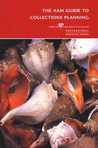
The AAM guide to collections planning
https://search.heritageburnaby.ca/link/museumlibrary6968
- Repository
- Burnaby Village Museum
- Collection
- Reference Collection
- Material Type
- Book
- ISBN
- 0931201888
- Call Number
- 069.5 GAR
- Place of Publication
- Washington, D.C.
- Publisher
- American Association of Museums
- Publication Date
- c2004
- Physical Description
- viii, 93 p. ; 23 cm.
- Library Subject (LOC)
- Museums--Collection management--United States
- Museums--United States--Planning
- Museums--United States--Management
- Notes
- Includes bibliographical references (p. 73-76) and index.
Cooking out-of-doors : fire building, outdoor kitchens, cook-out hikes, food planning, recipes
https://search.heritageburnaby.ca/link/museumlibrary6823
- Repository
- Burnaby Village Museum
- Collection
- Special Collection
- Material Type
- Book
- Accession Code
- BV015.35.16
- Call Number
- 641.575 GIR
- Contributor
- Melick, Sharon F.
- Place of Publication
- New York
- Publisher
- Girl Scouts of the United States of America
- Publication Date
- c1946
- Physical Description
- 123 p. : ill. ; 23 cm.
- Inscription
- "D. Bain" [handwritten in black ink on inside cover] "4th Co. N Burnaby Girl Guides" [stamped in red ink on title page and cover]
- Library Subject (LOC)
- Cookbooks--1940-1949
- Camping
- Outdoor cooking
- Notes
- "Illustrations by Sharon F. Melick"-- title page
The heritage of the British Columbia forest industry: a guide for planning, selection and interpretation of sites
https://search.heritageburnaby.ca/link/museumlibrary6481
- Repository
- Burnaby Village Museum
- Collection
- Special Collection
- Material Type
- Book
- Accession Code
- BV014.29.11
- Call Number
- 069 TAY
- Place of Publication
- Ottawa, Ont.
- Publisher
- Parks Canada
- Publication Date
- 1987
- Physical Description
- vi, 266 p. : ill., maps ; 28 cm.
- Library Subject (LOC)
- Forest products industry--History--British Columbia
- Historic sites--Interpretive programs--British Columbia
- Notes
- Author's full name and date : Taylor, C. J. (Christopher James), 1947-
Modern packaging encyclopedia and planning guide : 1972-3, vol. 45 no. 12A mid-December 1972 issue
https://search.heritageburnaby.ca/link/museumlibrary3541
- Repository
- Burnaby Village Museum
- Collection
- Special Collection
- Material Type
- Book
- Accession Code
- BV996.17.17
- Call Number
- 658.7 MCG
- Contributor
- Gross, Sidney
- Place of Publication
- New York
- Publisher
- McGraw-Hill Inc.
- Publication Date
- 1972
- Physical Description
- 545 p. : ill. (some col.) ; 29 cm.
- Library Subject (LOC)
- Packaging
- Containers
- Catalogs
- Notes
- Includes index.
Planning Map of Chinese Market Gardens on Marine Drive
https://search.heritageburnaby.ca/link/museumdescription4297
- Repository
- Burnaby Village Museum
- Date
- [between 1950 and 1959] (date of original), 2017 (date of duplication)
- Collection/Fonds
- Herbert Yee Law family fonds
- Description Level
- Item
- Physical Description
- 1 photograph (tiff) : col. ; 300 dpi
- Scope and Content
- Scanned copy of a survey plan of district lots 163, 162, 157, 158, and 165, near the Chinese Market Gardens along Marine Drive.
- Repository
- Burnaby Village Museum
- Collection/Fonds
- Herbert Yee Law family fonds
- Description Level
- Item
- Physical Description
- 1 photograph (tiff) : col. ; 300 dpi
- Scope and Content
- Scanned copy of a survey plan of district lots 163, 162, 157, 158, and 165, near the Chinese Market Gardens along Marine Drive.
- History
- Survey plan of district lots 163, 162, 157, 158, and 165, which is primarily the area farmed by Chinese and Chinese-Canadian market gardeners around Marine Drive between Royal Oak and Mandeville (present-day Nelson). Two Chinese/Chinese Canadian land owners can be seen on the map: N.G. Wah Sing (or Ng Wah Sing) and Yee Law (or Herbert Law).
- Geographic Access
- Marine Drive
- Accession Code
- BV017.40.2
- Access Restriction
- No restrictions
- Reproduction Restriction
- No known restrictions
- Date
- [between 1950 and 1959] (date of original), 2017 (date of duplication)
- Media Type
- Cartographic Material
- Historic Neighbourhood
- Fraser Arm (Historic Neighbourhood)
- Planning Study Area
- Big Bend Area
- Scan Resolution
- 300
- Scan Date
- 11/19/2017
- Scale
- 100
- Notes
- Title based on contents of copy scan of map
- Herbert Yee Law was donor's father and this map may have originally been his copy of the city planning/engineering documents.
Images
Provincial Prison Farm - Oakalla - Plan Showing Central Areas of the Property / Planning Department
https://search.heritageburnaby.ca/link/archivedescription6015
- Repository
- City of Burnaby Archives
- Date
- 1954
- Collection/Fonds
- Planning Department fonds
- Description Level
- Item
- Physical Description
- 1 plan : b&w ink on paper ; 148 x 92 cm folded to 39 x 23 cm
- Scope and Content
- One large plan of Oakalla and the surrounding areas, Plan no. 4436-1.
- Repository
- City of Burnaby Archives
- Date
- 1954
- Collection/Fonds
- Planning Department fonds
- Series
- Facilities series
- Physical Description
- 1 plan : b&w ink on paper ; 148 x 92 cm folded to 39 x 23 cm
- Material Details
- Scale : 1 inch = 50 feet
- Description Level
- Item
- Record No.
- 8966
- Accession Number
- 2001-02
- Scope and Content
- One large plan of Oakalla and the surrounding areas, Plan no. 4436-1.
- Media Type
- Cartographic Material
Selling methods : planning and handling sales, building trade through service records and systems, mail sales
https://search.heritageburnaby.ca/link/museumlibrary6802
- Repository
- Burnaby Village Museum
- Collection
- Special Collection
- Material Type
- Book
- Accession Code
- HV971.175.26
- Call Number
- 380.1 SHA
- Place of Publication
- Chicago
- Publisher
- A. W. Shaw
- Publication Date
- c1914
- Physical Description
- 200 p. : 21 cm.
- Inscription
- "W29" [handwritten and crossed out on page opposite front pastedown] "75" [handwritten on page opposite front pastedown] "Premium Stores 4543 Kingsway Burnaby 1, B.C., Canada"
- Library Subject (LOC)
- Marketing
- Selling
- Sales personnel
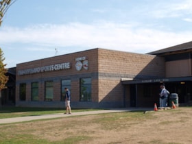
Bill Copeland Sports Centre & Burnaby Lake Arena
https://search.heritageburnaby.ca/link/landmark819
- Repository
- Burnaby Heritage Planning
- Geographic Access
- Kensington Avenue
- Associated Dates
- 1965
- Heritage Value
- In February 1965, the Planning Department presented to Burnaby Council a preliminary Development Plan entitled "Pacific Sports Centre," for the area immediately west of Burnaby Lake. This report proposed a conceptual plan for a comprehensive range of indoor and outdoor sporting facilities adjacent to Burnaby Lake. The idea was accepted by Council and led to the construction of the Burnaby Lake Rink beside the C.G. Brown Pool. In 1973, Burnaby and New Westminster jointly hosted the Canada Summer Games for which a rowing course and pavilion were built at Burnaby Lake and the success of the games and the sports facilities added within Burnaby Lake Park provided further stimulus for the creation of the sports and recreation facilities at this site.
- Historic Neighbourhood
- Burnaby Lake (Historic Neighbourhood)
- Planning Study Area
- Ardingley-Sprott Area
- Street Address
- 3676 Kensington Avenue
- Street View URL
- Google Maps Street View
Images
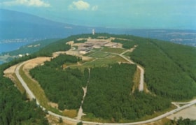
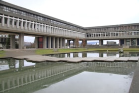
Simon Fraser University
https://search.heritageburnaby.ca/link/landmark639
- Repository
- Burnaby Heritage Planning
- Description
- The planning, design concept, design coordination, site development and landscaping for the original part of the campus were all under the control of Erickson/Massey. The complex was conceived as one building, with future growth occurring at the periphery. Tall buildings would have been out of scal…
- Associated Dates
- 1965
- Street View URL
- Google Maps Street View
- Repository
- Burnaby Heritage Planning
- Geographic Access
- University Drive
- Associated Dates
- 1965
- Description
- The planning, design concept, design coordination, site development and landscaping for the original part of the campus were all under the control of Erickson/Massey. The complex was conceived as one building, with future growth occurring at the periphery. Tall buildings would have been out of scale with the massive mountaintop ridge, so a series of horizontal terraced structures were designed that hugged the ridge and dissolve into the landscape. Following the linear peak of the mountain, the scheme organized various parts of the campus along an east/west line. The concept of a central academic quadrangle was conceived within the tradition of Oxford and Cambridge, and to enhance the sense of contemplative quiet, it was designed as a perfect square raised on massive pilotis, allowing stunning views through a landscaped courtyard. The connecting link was a gigantic space frame-developed in conjunction with Jeffrey Lindsay, a one-time associate of Buckminster Fuller-that provided shelter and a gathering-place for the students. Other architects who had placed among the top five in the competition were retained to design the individual components of the original plan: the Academic Quadrangle by Zoltan S. Kiss; the Theatre, Gymnasium & Swimming Pool by Duncan McNab & Associates; the Science Complex by Rhone & Iredale; and the Library by Robert F. Harrison.
- Heritage Value
- Following the end of the Second World War, there was unprecedented growth throughout the Lower Mainland. Many returning veterans had settled on the coast, and the loosening of wartime restrictions led to the creation of many new suburban developments throughout the region. The growing population strained existing facilities, and there was a recognition that new educational facilities had to be constructed to meet these growing demands. For many years, the only university in the province was the University of British Columbia. In the 1960s, new universities were planned for both Victoria and Burnaby to serve the wave of baby boomers just then going through high school. The dramatic site chosen for the Burnaby university was the top of Burnaby Mountain, with expansive views over mountain ranges and water. An architectural competition was held for a campus of 7,000 students that could eventually be expanded to 18,000. Of the many submissions, the judges reached unanimity on the winner, an outstanding scheme submitted by the firm of Erickson/Massey. The judges went even further, and recommended that every effort be made to ensure that the winning design be built as submitted. The new Chancellor, Gordon Shrum, agreed. The realization of this scheme won extensive recognition for the work of Arthur Erickson and Geoffrey Massey, and launched Erickson’s international career. In Erickson’s words: "Unlike any previous university, Simon Fraser is a direct translation into architecture of the expanding fields of knowledge that defy traditional boundaries, of the vital role of the university as both challenger and conservor of human culture, and of the university community as one in constant intellectual, spiritual and social interchange." The new school opened for classes in September 1965, nicknamed the “instant university,” and quickly gained a radical reputation. The startling futuristic architecture and open layout suited the explosive nature of the mid-1960s, when political and social traditions of all types were being questioned and student protests were common. Many of SFU’s programs were considered experimental, even controversial, and unrest and conflict on the campus continued for a number of years. Since this auspicious beginning 40 years ago, SFU has grown to house 25,000 students on three campuses. The core of the original campus, recognized world-wide as a profound work of architecture, remains essentially intact today.
- Locality
- Burnaby Mountain
- Historic Neighbourhood
- Barnet (Historic Neighbourhood)
- Planning Study Area
- Burnaby Mountain Area
- Architect
- Erickson/Massey
- Area
- 1360000.00
- Contributing Resource
- Building
- Ownership
- Private
- Street Address
- 8888 University Drive
- Street View URL
- Google Maps Street View
Images
Sussex-Nelson Neighbourhood
https://search.heritageburnaby.ca/link/landmark838
- Repository
- Burnaby Heritage Planning
- Associated Dates
- 1955-2008
- Heritage Value
- The Sussex-Nelson Neighbourhood is located just south of Metrotown and in 1980 was characterised as the most populated of all of Burnaby's Planning Study areas. The area immediately south of Metrotown was initially developed as post-war 1950s housing stock, while the sector south of Rumble was developed after the 1960s and 1970s as single-family housing.
- Historic Neighbourhood
- Alta Vista (Historic Neighbourhood)
- Planning Study Area
- Sussex-Nelson Area
Images
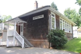
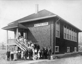
Seaforth Schoolhouse
https://search.heritageburnaby.ca/link/landmark541
- Repository
- Burnaby Heritage Planning
- Description
- The Seaforth Schoolhouse is a one-storey wood-frame rectangular plan building with a projecting entry porch, located in the Burnaby Village Museum.
- Associated Dates
- 1922
- Formal Recognition
- Heritage Designation, Community Heritage Register
- Repository
- Burnaby Heritage Planning
- Geographic Access
- Deer Lake Avenue
- Associated Dates
- 1922
- Formal Recognition
- Heritage Designation, Community Heritage Register
- Enactment Type
- Bylaw No. 8148
- Enactment Date
- 03/01/1984
- Description
- The Seaforth Schoolhouse is a one-storey wood-frame rectangular plan building with a projecting entry porch, located in the Burnaby Village Museum.
- Heritage Value
- The heritage value of the Seaforth Schoolhouse lies in its representation of a one-room school once located in one of the city’s rural districts. The school was constructed due to the demand of increasing population after the First World War, in what was then known as the Lozells District, so isolated at the time that parents were concerned about the danger to their children from wild bears and cougars that roamed the area. The school was named after its sponsor, the Seaforth Chapter of the Imperial Order of Daughters of the Empire. Bowman and Cullerne, the architects for the Burnaby School Board, designed the one room schoolhouse. It was constructed by local contractor, Alphonse J. Toebaert, following the standards of British Columbia public school architecture, which specified the plan and orientation of the building. It indicates the values and the design control of school boards of the time, and the central role of the provincial government in setting educational standards. The heritage value of this school also lies in its interpretive value within the Burnaby Village Museum. The site is an important cultural feature for the interpretation of Burnaby’s heritage to the public, illustrating the changes in the local school system over time. The school was moved to Burnaby Village Museum in 1983, and was opened to the public after extensive restoration in 1987. Both the interior and exterior have been restored and interpreted to the date of original construction. The North Vancouver School Board donated most of the early desks, and the remainder of the interior artifacts are from the museum’s own collection.
- Defining Elements
- Key elements that define the heritage character of the Seaforth Schoolhouse include its: - rectangular plan - hipped roof with cedar shingle cladding - hipped-roof entry porch - typical school fenestration of the era, with a bank of double-hung 6-over-6 wooden-sash windows on one facade - cedar shingle cladding - original and authentic interior elements such as interior mouldings, blackboards and desks
- Locality
- Deer Lake Park
- Historic Neighbourhood
- Burnaby Lake (Historic Neighbourhood)
- Planning Study Area
- Morley-Buckingham Area
- Organization
- Seaforth Chapter of the Imperial Order of Daughters of the Empire
- Burnaby School Board
- Burnaby Village Museum
- Architect
- Bowman and Cullerne
- Builder
- Alphonse J. Toebaert
- Function
- Primary Historic--One-Room School
- Primary Current--Museum
- Community
- Burnaby
- Cadastral Identifier
- P.I.D. No. 011-030-356 Legal Description: Parcel 1, District Lot 79 and District Lot 85, Group 1, New Westminster District, Reference Plan 77594
- Boundaries
- Burnaby Village Museum is comprised of a single municipally-owned property located at 6501 Deer Lake Avenue, Burnaby.
- Area
- 38,488.63
- Contributing Resource
- Building
- Landscape Feature
- Structure
- Ownership
- Public (local)
- Documentation
- Heritage Site Files: PC77000 20. City of Burnaby Planning and Building Department, 4949 Canada Way, Burnaby, B.C., V5G 1M2
- Street Address
- 6501 Deer Lake Avenue
![Planning Map of Chinese Market Gardens on Marine Drive, [between 1950 and 1959] (date of original), 2017 (date of duplication) thumbnail](/media/hpo/_Data/_BVM_Images/2017/2017_0040_0002_001.jpg?width=280)
