Narrow Results By
Subject
- Accidents 15
- Accidents - Automobile Accidents 30
- Accidents - Train Accidents 23
- Adminstrative Groups - Committees 4
- Adornment - Jewelry 7
- Adornment - Lapel Pins 1
- Advertising Medium 11
- Advertising Medium - Flyer 3
- Advertising Medium - Poster 16
- Advertising Medium - Signs and Signboards 221
- Aerial Photographs 132
- Agricultural Tools and Equipment 24
Lubbock farm
https://search.heritageburnaby.ca/link/museumdescription12773
- Repository
- Burnaby Village Museum
- Date
- 1977
- Collection/Fonds
- Century Park Museum Association fonds
- Description Level
- Item
- Physical Description
- 1 photograph : col. slide ; 35 mm
- Scope and Content
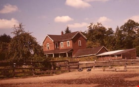
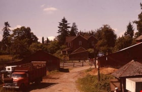
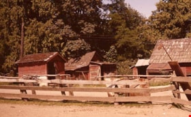
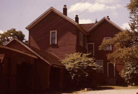
- Photograph of the Lubbock farmhouse, garage and horse paddocks. The house was located at 7803 Burris Street near Burnaby Lake.
- Repository
- Burnaby Village Museum
- Collection/Fonds
- Century Park Museum Association fonds
- Description Level
- Item
- Physical Description
- 1 photograph : col. slide ; 35 mm
- Scope and Content
- Photograph of the Lubbock farmhouse, garage and horse paddocks. The house was located at 7803 Burris Street near Burnaby Lake.
- History
- In 1977, Century Park Museum was granted access to the Sprott-Lubbock farm to appraise the heritage buildings for preservation. Buildings that were saved included the old farrier shed (BV985.1240.2) which was also used as a blacksmith shop and the Vorce tram station building (BV985.1240.3) from the old Burnaby Lake Interurban line which was used as a grain storage shed on the property. Segments of the original farmhouse and other out buildings were retained. Other buildings on the site were demolished to make way for a new housing development.
- Subjects
- Agriculture - Farms
- Names
- Lubbock farm
- Geographic Access
- Grandview Highway
- Burris Street
- Street Address
- 7803 Burris Street
- Accession Code
- BV020.5.450
- Access Restriction
- No restrictions
- Reproduction Restriction
- No known restrictions
- Date
- 1977
- Media Type
- Photograph
- Historic Neighbourhood
- Burnaby Lake (Historic Neighbourhood)
- Planning Study Area
- Morley-Buckingham Area
- Scan Resolution
- 2400
- Scan Date
- 13-Mar-20
- Scale
- 100
- Notes
- Title based on contents of photograph
Images

Lubbock farm
https://search.heritageburnaby.ca/link/museumdescription12790
- Repository
- Burnaby Village Museum
- Date
- 1977
- Collection/Fonds
- Century Park Museum Association fonds
- Description Level
- Item
- Physical Description
- 1 photograph : col. slide ; 35 mm
- Scope and Content
- Photograph of the Lubbock farm located at 7803 Burris Street near Burnaby Lake.
- Repository
- Burnaby Village Museum
- Collection/Fonds
- Century Park Museum Association fonds
- Description Level
- Item
- Physical Description
- 1 photograph : col. slide ; 35 mm
- Scope and Content
- Photograph of the Lubbock farm located at 7803 Burris Street near Burnaby Lake.
- History
- In 1977, Century Park Museum was granted access to the Sprott-Lubbock farm to appraise the heritage buildings for preservation. Buildings that were saved included the old farrier shed (BV985.1240.2) which was also used as a blacksmith shop and the Vorce tram station building (BV985.1240.3) from the old Burnaby Lake Interurban line which was used as a grain storage shed on the property. Segments of the original farmhouse and other out buildings were retained. Other buildings on the site were demolished to make way for a new housing development.
- Subjects
- Agriculture - Farms
- Names
- Lubbock farm
- Geographic Access
- Grandview Highway
- Burris Street
- Street Address
- 7803 Burris Street
- Accession Code
- BV020.5.467
- Access Restriction
- No restrictions
- Reproduction Restriction
- No known restrictions
- Date
- 1977
- Media Type
- Photograph
- Historic Neighbourhood
- Burnaby Lake (Historic Neighbourhood)
- Planning Study Area
- Morley-Buckingham Area
- Scan Resolution
- 2400
- Scan Date
- 13-Mar-20
- Scale
- 100
- Notes
- Title based on contents of photograph
Images

Lubbock farm
https://search.heritageburnaby.ca/link/museumdescription12791
- Repository
- Burnaby Village Museum
- Date
- 1977
- Collection/Fonds
- Century Park Museum Association fonds
- Description Level
- Item
- Physical Description
- 1 photograph : col. slide ; 35 mm
- Scope and Content
- Photograph of the Lubbock farm located at 7803 Burris Street near Burnaby Lake.
- Repository
- Burnaby Village Museum
- Collection/Fonds
- Century Park Museum Association fonds
- Description Level
- Item
- Physical Description
- 1 photograph : col. slide ; 35 mm
- Scope and Content
- Photograph of the Lubbock farm located at 7803 Burris Street near Burnaby Lake.
- History
- In 1977, Century Park Museum was granted access to the Sprott-Lubbock farm to appraise the heritage buildings for preservation. Buildings that were saved included the old farrier shed (BV985.1240.2) which was also used as a blacksmith shop and the Vorce tram station building (BV985.1240.3) from the old Burnaby Lake Interurban line which was used as a grain storage shed on the property. Segments of the original farmhouse and other out buildings were retained. Other buildings on the site were demolished to make way for a new housing development.
- Subjects
- Agriculture - Farms
- Names
- Lubbock farm
- Geographic Access
- Grandview Highway
- Burris Street
- Street Address
- 7803 Burris Street
- Accession Code
- BV020.5.468
- Access Restriction
- No restrictions
- Reproduction Restriction
- No known restrictions
- Date
- 1977
- Media Type
- Photograph
- Historic Neighbourhood
- Burnaby Lake (Historic Neighbourhood)
- Planning Study Area
- Morley-Buckingham Area
- Scan Resolution
- 2400
- Scan Date
- 13-Mar-20
- Scale
- 100
- Notes
- Title based on contents of photograph
Images

Lubbock farm
https://search.heritageburnaby.ca/link/museumdescription12792
- Repository
- Burnaby Village Museum
- Date
- 1977
- Collection/Fonds
- Century Park Museum Association fonds
- Description Level
- Item
- Physical Description
- 1 photograph : col. slide ; 35 mm
- Scope and Content
- Photograph of the Lubbock farm located at 7803 Burris Street near Burnaby Lake.
- Repository
- Burnaby Village Museum
- Collection/Fonds
- Century Park Museum Association fonds
- Description Level
- Item
- Physical Description
- 1 photograph : col. slide ; 35 mm
- Scope and Content
- Photograph of the Lubbock farm located at 7803 Burris Street near Burnaby Lake.
- History
- In 1977, Century Park Museum was granted access to the Sprott-Lubbock farm to appraise the heritage buildings for preservation. Buildings that were saved included the old farrier shed (BV985.1240.2) which was also used as a blacksmith shop and the Vorce tram station building (BV985.1240.3) from the old Burnaby Lake Interurban line which was used as a grain storage shed on the property. Segments of the original farmhouse and other out buildings were retained. Other buildings on the site were demolished to make way for a new housing development.
- Subjects
- Agriculture - Farms
- Names
- Lubbock farm
- Geographic Access
- Grandview Highway
- Burris Street
- Street Address
- 7803 Burris Street
- Accession Code
- BV020.5.469
- Access Restriction
- No restrictions
- Reproduction Restriction
- No known restrictions
- Date
- 1977
- Media Type
- Photograph
- Historic Neighbourhood
- Burnaby Lake (Historic Neighbourhood)
- Planning Study Area
- Morley-Buckingham Area
- Scan Resolution
- 2400
- Scan Date
- 13-Mar-20
- Scale
- 100
- Notes
- Title based on contents of photograph
Images

Lubbock farm
https://search.heritageburnaby.ca/link/museumdescription12813
- Repository
- Burnaby Village Museum
- Date
- 1977
- Collection/Fonds
- Century Park Museum Association fonds
- Description Level
- Item
- Physical Description
- 1 photograph : col. slide ; 35 mm
- Scope and Content
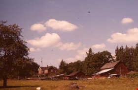
- Photograph of the Lubbock family farm. A few out buildings and vehicles are visible in the foreground and the house is visible in the background.
- Repository
- Burnaby Village Museum
- Collection/Fonds
- Century Park Museum Association fonds
- Description Level
- Item
- Physical Description
- 1 photograph : col. slide ; 35 mm
- Scope and Content
- Photograph of the Lubbock family farm. A few out buildings and vehicles are visible in the foreground and the house is visible in the background.
- History
- In 1977, Century Park Museum was granted access to the Sprott-Lubbock farm to appraise the heritage buildings for preservation. Buildings that were saved included the old farrier shed (BV985.1240.2) which was also used as a blacksmith shop and the Vorce tram station building (BV985.1240.3) from the old Burnaby Lake Interurban line which was used as a grain storage shed on the property. Segments of the original farmhouse and other out buildings were retained. Other buildings on the site were demolished to make way for a new housing development.
- Subjects
- Agriculture - Farms
- Names
- Lubbock farm
- Geographic Access
- Grandview Highway
- Burris Street
- Street Address
- 7803 Burris Street
- Accession Code
- BV020.5.480
- Access Restriction
- No restrictions
- Reproduction Restriction
- No known restrictions
- Date
- 1977
- Media Type
- Photograph
- Historic Neighbourhood
- Burnaby Lake (Historic Neighbourhood)
- Planning Study Area
- Morley-Buckingham Area
- Scan Resolution
- 2400
- Scan Date
- 13-Mar-20
- Scale
- 100
- Notes
- Title based on contents of photograph
Images

Lubbock farm
https://search.heritageburnaby.ca/link/museumdescription12815
- Repository
- Burnaby Village Museum
- Date
- 1977
- Collection/Fonds
- Century Park Museum Association fonds
- Description Level
- Item
- Physical Description
- 1 photograph : col. slide ; 35 mm
- Scope and Content
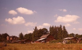
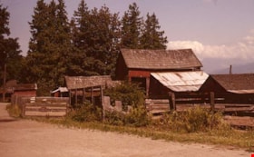
- Photograph of a barn and out buildings on the Lubbock family farm.
- Repository
- Burnaby Village Museum
- Collection/Fonds
- Century Park Museum Association fonds
- Description Level
- Item
- Physical Description
- 1 photograph : col. slide ; 35 mm
- Scope and Content
- Photograph of a barn and out buildings on the Lubbock family farm.
- History
- In 1977, Century Park Museum was granted access to the Sprott-Lubbock farm to appraise the heritage buildings for preservation. Buildings that were saved included the old farrier shed (BV985.1240.2) which was also used as a blacksmith shop and the Vorce tram station building (BV985.1240.3) from the old Burnaby Lake Interurban line which was used as a grain storage shed on the property. Segments of the original farmhouse and other out buildings were retained. Other buildings on the site were demolished to make way for a new housing development.
- Subjects
- Agriculture - Farms
- Names
- Lubbock farm
- Geographic Access
- Grandview Highway
- Burris Street
- Street Address
- 7803 Burris Street
- Accession Code
- BV020.5.482
- Access Restriction
- No restrictions
- Reproduction Restriction
- No known restrictions
- Date
- 1977
- Media Type
- Photograph
- Historic Neighbourhood
- Burnaby Lake (Historic Neighbourhood)
- Planning Study Area
- Morley-Buckingham Area
- Scan Resolution
- 2400
- Scan Date
- 13-Mar-20
- Scale
- 100
- Notes
- Title based on contents of photograph
Images

Lubbock farm
https://search.heritageburnaby.ca/link/museumdescription12819
- Repository
- Burnaby Village Museum
- Date
- 1977
- Collection/Fonds
- Century Park Museum Association fonds
- Description Level
- Item
- Physical Description
- 1 photograph : col. slide ; 35 mm
- Scope and Content
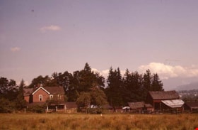
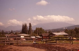
- Photograph of fenced paddock and buildings on the Lubbock family farm. Burnaby mountain is visible in the distance.
- Repository
- Burnaby Village Museum
- Collection/Fonds
- Century Park Museum Association fonds
- Description Level
- Item
- Physical Description
- 1 photograph : col. slide ; 35 mm
- Scope and Content
- Photograph of fenced paddock and buildings on the Lubbock family farm. Burnaby mountain is visible in the distance.
- History
- In 1977, Century Park Museum was granted access to the Sprott-Lubbock farm to appraise the heritage buildings for preservation. Buildings that were saved included the old farrier shed (BV985.1240.2) which was also used as a blacksmith shop and the Vorce tram station building (BV985.1240.3) from the old Burnaby Lake Interurban line which was used as a grain storage shed on the property. Segments of the original farmhouse and other out buildings were retained. Other buildings on the site were demolished to make way for a new housing development.
- Subjects
- Agriculture - Farms
- Names
- Lubbock farm
- Geographic Access
- Grandview Highway
- Burris Street
- Street Address
- 7803 Burris Street
- Accession Code
- BV020.5.486
- Access Restriction
- No restrictions
- Reproduction Restriction
- No known restrictions
- Date
- 1977
- Media Type
- Photograph
- Historic Neighbourhood
- Burnaby Lake (Historic Neighbourhood)
- Planning Study Area
- Morley-Buckingham Area
- Scan Resolution
- 2400
- Scan Date
- 13-Mar-20
- Scale
- 100
- Notes
- Title based on contents of photograph
Images
Lubbock farm buildings
https://search.heritageburnaby.ca/link/museumdescription12787
- Repository
- Burnaby Village Museum
- Date
- 1977
- Collection/Fonds
- Century Park Museum Association fonds
- Description Level
- Item
- Physical Description
- 1 photograph : col. slide ; 35 mm
- Scope and Content
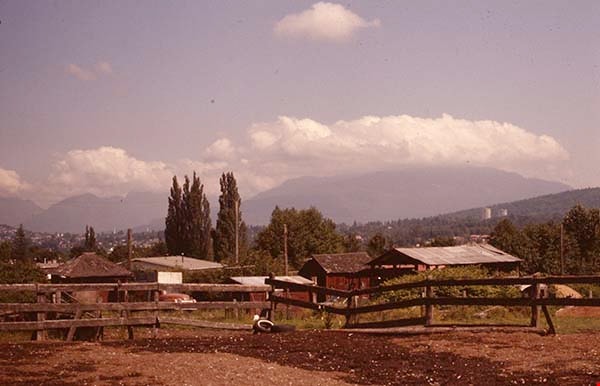
- Photograph of out buildings on the Lubbock farm located 7803 Burris Street near Burnaby Lake. A fence and horse paddock is visible in the foreground.
- Repository
- Burnaby Village Museum
- Collection/Fonds
- Century Park Museum Association fonds
- Description Level
- Item
- Physical Description
- 1 photograph : col. slide ; 35 mm
- Scope and Content
- Photograph of out buildings on the Lubbock farm located 7803 Burris Street near Burnaby Lake. A fence and horse paddock is visible in the foreground.
- History
- In 1977, Century Park Museum was granted access to the Sprott-Lubbock farm to appraise the heritage buildings for preservation. Buildings that were saved included the old farrier shed (BV985.1240.2) which was also used as a blacksmith shop and the Vorce tram station building (BV985.1240.3) from the old Burnaby Lake Interurban line which was used as a grain storage shed on the property. Segments of the original farmhouse and other out buildings were retained. Other buildings on the site were demolished to make way for a new housing development.
- Subjects
- Agriculture - Farms
- Names
- Lubbock farm
- Geographic Access
- Grandview Highway
- Burris Street
- Street Address
- 7803 Burris Street
- Accession Code
- BV020.5.464
- Access Restriction
- No restrictions
- Reproduction Restriction
- No known restrictions
- Date
- 1977
- Media Type
- Photograph
- Historic Neighbourhood
- Burnaby Lake (Historic Neighbourhood)
- Planning Study Area
- Morley-Buckingham Area
- Scan Resolution
- 2400
- Scan Date
- 13-Mar-20
- Scale
- 100
- Notes
- Title based on contents of photograph
Images

![Lubbock farmhouse, [1935] thumbnail](/media/hpo/_Data/_Archives_Images/_Unrestricted/316/342-001.jpg?width=280)
Lubbock farmhouse
https://search.heritageburnaby.ca/link/archivedescription37227
- Repository
- City of Burnaby Archives
- Date
- [1935]
- Collection/Fonds
- Burnaby Historical Society fonds
- Description Level
- Item
- Physical Description
- 1 photograph : sepia ; 5.5 x 8 cm
- Scope and Content
- Photograph of the exterior of the Lubbock farmhouse at Canada Way and Burris.
- Repository
- City of Burnaby Archives
- Date
- [1935]
- Collection/Fonds
- Burnaby Historical Society fonds
- Subseries
- Lubbock family subseries
- Physical Description
- 1 photograph : sepia ; 5.5 x 8 cm
- Description Level
- Item
- Record No.
- 342-001
- Access Restriction
- No restrictions
- Reproduction Restriction
- No known restrictions
- Accession Number
- BHS1994-02
- Scope and Content
- Photograph of the exterior of the Lubbock farmhouse at Canada Way and Burris.
- Media Type
- Photograph
- Notes
- Title based on contents of photograph
- Geographic Access
- Grandview Highway
- Canada Way
- Burris Street
- Street Address
- 7803 Burris Street
- Historic Neighbourhood
- Burnaby Lake (Historic Neighbourhood)
- Planning Study Area
- Morley-Buckingham Area
Images
![Lubbock farmhouse, [1935] thumbnail](/media/hpo/_Data/_Archives_Images/_Unrestricted/316/342-001.jpg)
![Lubbock farmhouse, [1935] thumbnail](/media/hpo/_Data/_Archives_Images/_Unrestricted/316/342-002.jpg?width=280)
Lubbock farmhouse
https://search.heritageburnaby.ca/link/archivedescription37228
- Repository
- City of Burnaby Archives
- Date
- [1935]
- Collection/Fonds
- Burnaby Historical Society fonds
- Description Level
- Item
- Physical Description
- 1 photograph : sepia ; 5.5 x 8 cm
- Scope and Content
- Photograph of the Lubbock family farmhouse at Burris Street and Canada Way.
- Repository
- City of Burnaby Archives
- Date
- [1935]
- Collection/Fonds
- Burnaby Historical Society fonds
- Subseries
- Lubbock family subseries
- Physical Description
- 1 photograph : sepia ; 5.5 x 8 cm
- Description Level
- Item
- Record No.
- 342-002
- Access Restriction
- No restrictions
- Reproduction Restriction
- No known restrictions
- Accession Number
- BHS1994-02
- Scope and Content
- Photograph of the Lubbock family farmhouse at Burris Street and Canada Way.
- Media Type
- Photograph
- Notes
- Title based on contents of photograph
- Geographic Access
- Grandview Highway
- Canada Way
- Burris Street
- Street Address
- 7803 Burris Street
- Historic Neighbourhood
- Burnaby Lake (Historic Neighbourhood)
- Planning Study Area
- Morley-Buckingham Area
Images
![Lubbock farmhouse, [1935] thumbnail](/media/hpo/_Data/_Archives_Images/_Unrestricted/316/342-002.jpg)
![Lubbock farmhouse, [1935] thumbnail](/media/hpo/_Data/_Archives_Images/_Unrestricted/316/342-003.jpg?width=280)
Lubbock farmhouse
https://search.heritageburnaby.ca/link/archivedescription37229
- Repository
- City of Burnaby Archives
- Date
- [1935]
- Collection/Fonds
- Burnaby Historical Society fonds
- Description Level
- Item
- Physical Description
- 1 photograph : sepia ; 5.5 x 8 cm
- Scope and Content
- Photograph of the Lubbock family farmhouse and garden at Burris Street and Canada Way.
- Repository
- City of Burnaby Archives
- Date
- [1935]
- Collection/Fonds
- Burnaby Historical Society fonds
- Subseries
- Lubbock family subseries
- Physical Description
- 1 photograph : sepia ; 5.5 x 8 cm
- Description Level
- Item
- Record No.
- 342-003
- Access Restriction
- No restrictions
- Reproduction Restriction
- No known restrictions
- Accession Number
- BHS1994-02
- Scope and Content
- Photograph of the Lubbock family farmhouse and garden at Burris Street and Canada Way.
- Media Type
- Photograph
- Notes
- Title based on contents of photograph
- Geographic Access
- Grandview Highway
- Canada Way
- Burris Street
- Street Address
- 7803 Burris Street
- Historic Neighbourhood
- Burnaby Lake (Historic Neighbourhood)
- Planning Study Area
- Morley-Buckingham Area
Images
![Lubbock farmhouse, [1935] thumbnail](/media/hpo/_Data/_Archives_Images/_Unrestricted/316/342-003.jpg)
Lubbock farmhouse
https://search.heritageburnaby.ca/link/museumdescription12755
- Repository
- Burnaby Village Museum
- Date
- 1977
- Collection/Fonds
- Century Park Museum Association fonds
- Description Level
- Item
- Physical Description
- 1 photograph : col. slide ; 35 mm
- Scope and Content
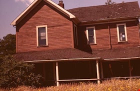
- Photograph of the Lubbock farmhouse located at 7803 Burris Street near Burnaby Lake.
- Repository
- Burnaby Village Museum
- Collection/Fonds
- Century Park Museum Association fonds
- Description Level
- Item
- Physical Description
- 1 photograph : col. slide ; 35 mm
- Scope and Content
- Photograph of the Lubbock farmhouse located at 7803 Burris Street near Burnaby Lake.
- History
- In 1977, Century Park Museum was granted access to the Sprott-Lubbock farm to appraise the heritage buildings for preservation. Buildings that were saved included the old farrier shed (BV985.1240.2) which was also used as a blacksmith shop and the Vorce tram station building (BV985.1240.3) from the old Burnaby Lake Interurban line which was used as a grain storage shed on the property. Segments of the original farmhouse and other out buildings were retained. Other buildings on the site were demolished to make way for a new housing development.
- Subjects
- Agriculture - Farms
- Names
- Burnaby Village Museum
- Geographic Access
- Grandview Highway
- Burris Street
- Street Address
- 7803 Burris Street
- Accession Code
- BV020.5.432
- Access Restriction
- No restrictions
- Reproduction Restriction
- No known restrictions
- Date
- 1977
- Media Type
- Photograph
- Historic Neighbourhood
- Burnaby Lake (Historic Neighbourhood)
- Planning Study Area
- Morley-Buckingham Area
- Scan Resolution
- 2400
- Scan Date
- 13-Mar-20
- Scale
- 100
- Notes
- Title based on contents of photograph
Images

Lubbock farmhouse
https://search.heritageburnaby.ca/link/museumdescription12758
- Repository
- Burnaby Village Museum
- Date
- 1977
- Collection/Fonds
- Century Park Museum Association fonds
- Description Level
- Item
- Physical Description
- 1 photograph : col. slide ; 35 mm
- Scope and Content
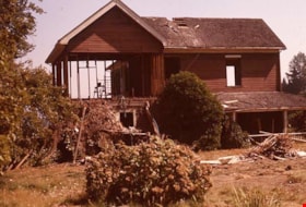
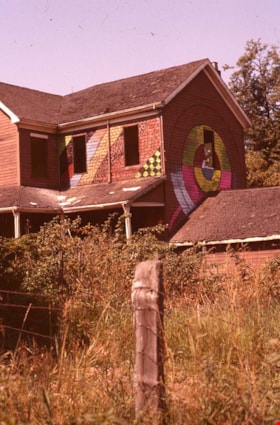
- Photograph of the Lubbock farmhouse located at 7803 Burris Street near Burnaby Lake. The windows and some walls are missing and there is a hole in the roof.
- Repository
- Burnaby Village Museum
- Collection/Fonds
- Century Park Museum Association fonds
- Description Level
- Item
- Physical Description
- 1 photograph : col. slide ; 35 mm
- Scope and Content
- Photograph of the Lubbock farmhouse located at 7803 Burris Street near Burnaby Lake. The windows and some walls are missing and there is a hole in the roof.
- History
- In 1977, Century Park Museum was granted access to the Sprott-Lubbock farm to appraise the heritage buildings for preservation. Buildings that were saved included the old farrier shed (BV985.1240.2) which was also used as a blacksmith shop and the Vorce tram station building (BV985.1240.3) from the old Burnaby Lake Interurban line which was used as a grain storage shed on the property. Segments of the original farmhouse and other out buildings were retained. Other buildings on the site were demolished to make way for a new housing development.
- Subjects
- Agriculture - Farms
- Names
- Lubbock farm
- Geographic Access
- Grandview Highway
- Burris Street
- Street Address
- 7803 Burris Street
- Accession Code
- BV020.5.435
- Access Restriction
- No restrictions
- Reproduction Restriction
- No known restrictions
- Date
- 1977
- Media Type
- Photograph
- Historic Neighbourhood
- Burnaby Lake (Historic Neighbourhood)
- Planning Study Area
- Morley-Buckingham Area
- Scan Resolution
- 2400
- Scan Date
- 13-Mar-20
- Scale
- 100
- Notes
- Title based on contents of photograph
Images

Lubbock farmhouse
https://search.heritageburnaby.ca/link/museumdescription12759
- Repository
- Burnaby Village Museum
- Date
- 1977
- Collection/Fonds
- Century Park Museum Association fonds
- Description Level
- Item
- Physical Description
- 1 photograph : col. slide ; 35 mm
- Scope and Content
- Photograph of the Lubbock farmhouse located at 7803 Burris Street near Burnaby Lake. The windows and some walls are missing and there is a hole in the roof.
- Repository
- Burnaby Village Museum
- Collection/Fonds
- Century Park Museum Association fonds
- Description Level
- Item
- Physical Description
- 1 photograph : col. slide ; 35 mm
- Scope and Content
- Photograph of the Lubbock farmhouse located at 7803 Burris Street near Burnaby Lake. The windows and some walls are missing and there is a hole in the roof.
- History
- In 1977, Century Park Museum was granted access to the Sprott-Lubbock farm to appraise the heritage buildings for preservation. Buildings that were saved included the old farrier shed (BV985.1240.2) which was also used as a blacksmith shop and the Vorce tram station building (BV985.1240.3) from the old Burnaby Lake Interurban line which was used as a grain storage shed on the property. Segments of the original farmhouse and other out buildings were retained. Other buildings on the site were demolished to make way for a new housing development.
- Subjects
- Agriculture - Farms
- Names
- Lubbock farm
- Geographic Access
- Grandview Highway
- Burris Street
- Street Address
- 7803 Burris Street
- Accession Code
- BV020.5.436
- Access Restriction
- No restrictions
- Reproduction Restriction
- No known restrictions
- Date
- 1977
- Media Type
- Photograph
- Historic Neighbourhood
- Burnaby Lake (Historic Neighbourhood)
- Planning Study Area
- Morley-Buckingham Area
- Scan Resolution
- 2400
- Scan Date
- 13-Mar-20
- Scale
- 100
- Notes
- Title based on contents of photograph
Images

Lubbock farmhouse
https://search.heritageburnaby.ca/link/museumdescription12770
- Repository
- Burnaby Village Museum
- Date
- 1977
- Collection/Fonds
- Century Park Museum Association fonds
- Description Level
- Item
- Physical Description
- 1 photograph : col. slide ; 35 mm
- Scope and Content
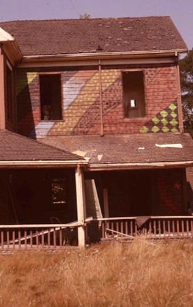
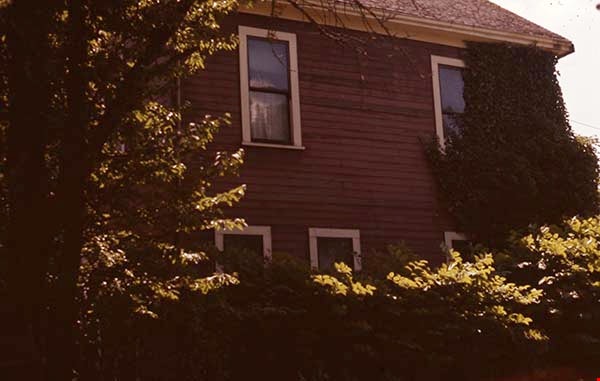
- Photograph of the Lubbock farmhouse. The house and farm were located at 7803 Burris Street near Burnaby Lake. A colour mural has been painted on the side of the house.
- Repository
- Burnaby Village Museum
- Collection/Fonds
- Century Park Museum Association fonds
- Description Level
- Item
- Physical Description
- 1 photograph : col. slide ; 35 mm
- Scope and Content
- Photograph of the Lubbock farmhouse. The house and farm were located at 7803 Burris Street near Burnaby Lake. A colour mural has been painted on the side of the house.
- History
- In 1977, Century Park Museum was granted access to the Sprott-Lubbock farm to appraise the heritage buildings for preservation. Buildings that were saved included the old farrier shed (BV985.1240.2) which was also used as a blacksmith shop and the Vorce tram station building (BV985.1240.3) from the old Burnaby Lake Interurban line which was used as a grain storage shed on the property. Segments of the original farmhouse and other out buildings were retained. Other buildings on the site were demolished to make way for a new housing development.
- Subjects
- Agriculture - Farms
- Names
- Lubbock farm
- Geographic Access
- Grandview Highway
- Burris Street
- Street Address
- 7803 Burris Street
- Accession Code
- BV020.5.447
- Access Restriction
- No restrictions
- Reproduction Restriction
- No known restrictions
- Date
- 1977
- Media Type
- Photograph
- Historic Neighbourhood
- Burnaby Lake (Historic Neighbourhood)
- Planning Study Area
- Morley-Buckingham Area
- Scan Resolution
- 2400
- Scan Date
- 13-Mar-20
- Scale
- 100
- Notes
- Title based on contents of photograph
Images

Lubbock farmhouse
https://search.heritageburnaby.ca/link/museumdescription12775
- Repository
- Burnaby Village Museum
- Date
- 1977
- Collection/Fonds
- Century Park Museum Association fonds
- Description Level
- Item
- Physical Description
- 1 photograph : col. slide ; 35 mm
- Scope and Content
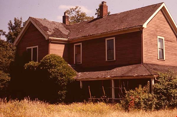
- Photograph of the Lubbock farmhouse that was located at 7803 Burris Street near Burnaby Lake. Tall grass and wildflowers are visible in the foreground.
- Repository
- Burnaby Village Museum
- Collection/Fonds
- Century Park Museum Association fonds
- Description Level
- Item
- Physical Description
- 1 photograph : col. slide ; 35 mm
- Scope and Content
- Photograph of the Lubbock farmhouse that was located at 7803 Burris Street near Burnaby Lake. Tall grass and wildflowers are visible in the foreground.
- History
- In 1977, Century Park Museum was granted access to the Sprott-Lubbock farm to appraise the heritage buildings for preservation. Buildings that were saved included the old farrier shed (BV985.1240.2) which was also used as a blacksmith shop and the Vorce tram station building (BV985.1240.3) from the old Burnaby Lake Interurban line which was used as a grain storage shed on the property. Segments of the original farmhouse and other out buildings were retained. Other buildings on the site were demolished to make way for a new housing development.
- Subjects
- Agriculture - Farms
- Names
- Lubbock farm
- Geographic Access
- Grandview Highway
- Burris Street
- Street Address
- 7803 Burris Street
- Accession Code
- BV020.5.452
- Access Restriction
- No restrictions
- Reproduction Restriction
- No known restrictions
- Date
- 1977
- Media Type
- Photograph
- Historic Neighbourhood
- Burnaby Lake (Historic Neighbourhood)
- Planning Study Area
- Morley-Buckingham Area
- Scan Resolution
- 2400
- Scan Date
- 13-Mar-20
- Scale
- 100
- Notes
- Title based on contents of photograph
Images


Lubbock farmhouse
https://search.heritageburnaby.ca/link/museumdescription12782
- Repository
- Burnaby Village Museum
- Date
- 1977
- Collection/Fonds
- Century Park Museum Association fonds
- Description Level
- Item
- Physical Description
- 1 photograph : col. slide ; 35 mm
- Scope and Content
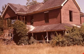
- Photograph of the Lubbock farmhouse that was located at 7803 Burris Street near Burnaby Lake. Tall grass and wildflowers are visible in the foreground.
- Repository
- Burnaby Village Museum
- Collection/Fonds
- Century Park Museum Association fonds
- Description Level
- Item
- Physical Description
- 1 photograph : col. slide ; 35 mm
- Scope and Content
- Photograph of the Lubbock farmhouse that was located at 7803 Burris Street near Burnaby Lake. Tall grass and wildflowers are visible in the foreground.
- History
- In 1977, Century Park Museum was granted access to the Sprott-Lubbock farm to appraise the heritage buildings for preservation. Buildings that were saved included the old farrier shed (BV985.1240.2) which was also used as a blacksmith shop and the Vorce tram station building (BV985.1240.3) from the old Burnaby Lake Interurban line which was used as a grain storage shed on the property. Segments of the original farmhouse and other out buildings were retained. Other buildings on the site were demolished to make way for a new housing development.
- Subjects
- Agriculture - Farms
- Names
- Lubbock farm
- Geographic Access
- Grandview Highway
- Burris Street
- Street Address
- 7803 Burris Street
- Accession Code
- BV020.5.459
- Access Restriction
- No restrictions
- Reproduction Restriction
- No known restrictions
- Date
- 1977
- Media Type
- Photograph
- Historic Neighbourhood
- Burnaby Lake (Historic Neighbourhood)
- Planning Study Area
- Morley-Buckingham Area
- Scan Resolution
- 2400
- Scan Date
- 13-Mar-20
- Scale
- 100
- Notes
- Title based on contents of photograph
Images
Lubbock farmhouse
https://search.heritageburnaby.ca/link/museumdescription12785
- Repository
- Burnaby Village Museum
- Date
- 1977
- Collection/Fonds
- Century Park Museum Association fonds
- Description Level
- Item
- Physical Description
- 1 photograph : col. slide ; 35 mm
- Scope and Content
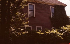
- Photograph of the Lubbock farmhouse that was located at 7803 Burris Street near Burnaby Lake. Trees and bushes surround the walls of the house.
- Repository
- Burnaby Village Museum
- Collection/Fonds
- Century Park Museum Association fonds
- Description Level
- Item
- Physical Description
- 1 photograph : col. slide ; 35 mm
- Scope and Content
- Photograph of the Lubbock farmhouse that was located at 7803 Burris Street near Burnaby Lake. Trees and bushes surround the walls of the house.
- History
- In 1977, Century Park Museum was granted access to the Sprott-Lubbock farm to appraise the heritage buildings for preservation. Buildings that were saved included the old farrier shed (BV985.1240.2) which was also used as a blacksmith shop and the Vorce tram station building (BV985.1240.3) from the old Burnaby Lake Interurban line which was used as a grain storage shed on the property. Segments of the original farmhouse and other out buildings were retained. Other buildings on the site were demolished to make way for a new housing development.
- Subjects
- Agriculture - Farms
- Names
- Lubbock farm
- Geographic Access
- Grandview Highway
- Burris Street
- Street Address
- 7803 Burris Street
- Accession Code
- BV020.5.462
- Access Restriction
- No restrictions
- Reproduction Restriction
- No known restrictions
- Date
- 1977
- Media Type
- Photograph
- Historic Neighbourhood
- Burnaby Lake (Historic Neighbourhood)
- Planning Study Area
- Morley-Buckingham Area
- Scan Resolution
- 2400
- Scan Date
- 13-Mar-20
- Scale
- 100
- Notes
- Title based on contents of photograph
Images
Lubbock farmhouse
https://search.heritageburnaby.ca/link/museumdescription12794
- Repository
- Burnaby Village Museum
- Date
- 1977
- Collection/Fonds
- Century Park Museum Association fonds
- Description Level
- Item
- Physical Description
- 1 photograph : col. slide ; 35 mm
- Scope and Content
- Photograph of the Lubbock farmhouse located at 7803 Burris Street near Burnaby Lake.
- Repository
- Burnaby Village Museum
- Collection/Fonds
- Century Park Museum Association fonds
- Description Level
- Item
- Physical Description
- 1 photograph : col. slide ; 35 mm
- Scope and Content
- Photograph of the Lubbock farmhouse located at 7803 Burris Street near Burnaby Lake.
- History
- In 1977, Century Park Museum was granted access to the Sprott-Lubbock farm to appraise the heritage buildings for preservation. Buildings that were saved included the old farrier shed (BV985.1240.2) which was also used as a blacksmith shop and the Vorce tram station building (BV985.1240.3) from the old Burnaby Lake Interurban line which was used as a grain storage shed on the property. Segments of the original farmhouse and other out buildings were retained. Other buildings on the site were demolished to make way for a new housing development.
- Subjects
- Agriculture - Farms
- Names
- Lubbock farm
- Geographic Access
- Grandview Highway
- Burris Street
- Street Address
- 7803 Burris Street
- Accession Code
- BV020.5.471
- Access Restriction
- No restrictions
- Reproduction Restriction
- No known restrictions
- Date
- 1977
- Media Type
- Photograph
- Historic Neighbourhood
- Burnaby Lake (Historic Neighbourhood)
- Planning Study Area
- Morley-Buckingham Area
- Scan Resolution
- 2400
- Scan Date
- 13-Mar-20
- Scale
- 100
- Notes
- Title based on contents of photograph
Images

Lubbock farmhouse and shed
https://search.heritageburnaby.ca/link/museumdescription12767
- Repository
- Burnaby Village Museum
- Date
- 1977
- Collection/Fonds
- Century Park Museum Association fonds
- Description Level
- Item
- Physical Description
- 1 photograph : col. slide ; 35 mm
- Scope and Content
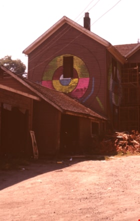
- Photograph of the Lubbock farmhouse and shed. The house and farm were located at 7803 Burris Street near Burnaby Lake. A colour mural has been painted on the side of the house.
- Repository
- Burnaby Village Museum
- Collection/Fonds
- Century Park Museum Association fonds
- Description Level
- Item
- Physical Description
- 1 photograph : col. slide ; 35 mm
- Scope and Content
- Photograph of the Lubbock farmhouse and shed. The house and farm were located at 7803 Burris Street near Burnaby Lake. A colour mural has been painted on the side of the house.
- History
- In 1977, Century Park Museum was granted access to the Sprott-Lubbock farm to appraise the heritage buildings for preservation. Buildings that were saved included the old farrier shed (BV985.1240.2) which was also used as a blacksmith shop and the Vorce tram station building (BV985.1240.3) from the old Burnaby Lake Interurban line which was used as a grain storage shed on the property. Segments of the original farmhouse and other out buildings were retained. Other buildings on the site were demolished to make way for a new housing development.
- Subjects
- Agriculture - Farms
- Names
- Lubbock farm
- Geographic Access
- Grandview Highway
- Burris Street
- Street Address
- 7803 Burris Street
- Accession Code
- BV020.5.444
- Access Restriction
- No restrictions
- Reproduction Restriction
- No known restrictions
- Date
- 1977
- Media Type
- Photograph
- Historic Neighbourhood
- Burnaby Lake (Historic Neighbourhood)
- Planning Study Area
- Morley-Buckingham Area
- Scan Resolution
- 2400
- Scan Date
- 13-Mar-20
- Scale
- 100
- Notes
- Title based on contents of photograph
Images

Lubbock farmhouse and shed
https://search.heritageburnaby.ca/link/museumdescription12769
- Repository
- Burnaby Village Museum
- Date
- 1977
- Collection/Fonds
- Century Park Museum Association fonds
- Description Level
- Item
- Physical Description
- 1 photograph : col. slide ; 35 mm
- Scope and Content
- Photograph of the Lubbock farmhouse and shed. The house and farm were located at 7803 Burris Street near Burnaby Lake. A colour mural has been painted on the side of the house.
- Repository
- Burnaby Village Museum
- Collection/Fonds
- Century Park Museum Association fonds
- Description Level
- Item
- Physical Description
- 1 photograph : col. slide ; 35 mm
- Scope and Content
- Photograph of the Lubbock farmhouse and shed. The house and farm were located at 7803 Burris Street near Burnaby Lake. A colour mural has been painted on the side of the house.
- History
- In 1977, Century Park Museum was granted access to the Sprott-Lubbock farm to appraise the heritage buildings for preservation. Buildings that were saved included the old farrier shed (BV985.1240.2) which was also used as a blacksmith shop and the Vorce tram station building (BV985.1240.3) from the old Burnaby Lake Interurban line which was used as a grain storage shed on the property. Segments of the original farmhouse and other out buildings were retained. Other buildings on the site were demolished to make way for a new housing development.
- Subjects
- Agriculture - Farms
- Names
- Lubbock farm
- Geographic Access
- Grandview Highway
- Burris Street
- Street Address
- 7803 Burris Street
- Accession Code
- BV020.5.446
- Access Restriction
- No restrictions
- Reproduction Restriction
- No known restrictions
- Date
- 1977
- Media Type
- Photograph
- Historic Neighbourhood
- Burnaby Lake (Historic Neighbourhood)
- Planning Study Area
- Morley-Buckingham Area
- Scan Resolution
- 2400
- Scan Date
- 13-Mar-20
- Scale
- 100
- Notes
- Title based on contents of photograph
Images

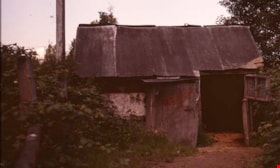
Lubbock farm shed
https://search.heritageburnaby.ca/link/museumdescription12780
- Repository
- Burnaby Village Museum
- Date
- 1977
- Collection/Fonds
- Century Park Museum Association fonds
- Description Level
- Item
- Physical Description
- 1 photograph : col. slide ; 35 mm
- Scope and Content
- Photograph of a small farm shed on the property of the Lubbock farm located at 7803 Burris Street near Burnaby Lake.
- Repository
- Burnaby Village Museum
- Collection/Fonds
- Century Park Museum Association fonds
- Description Level
- Item
- Physical Description
- 1 photograph : col. slide ; 35 mm
- Scope and Content
- Photograph of a small farm shed on the property of the Lubbock farm located at 7803 Burris Street near Burnaby Lake.
- History
- In 1977, Century Park Museum was granted access to the Sprott-Lubbock farm to appraise the heritage buildings for preservation. Buildings that were saved included the old farrier shed (BV985.1240.2) which was also used as a blacksmith shop and the Vorce tram station building (BV985.1240.3) from the old Burnaby Lake Interurban line which was used as a grain storage shed on the property. Segments of the original farmhouse and other out buildings were retained. Other buildings on the site were demolished to make way for a new housing development.
- Subjects
- Agriculture - Farms
- Names
- Lubbock farm
- Geographic Access
- Grandview Highway
- Burris Street
- Street Address
- 7803 Burris Street
- Accession Code
- BV020.5.457
- Access Restriction
- No restrictions
- Reproduction Restriction
- No known restrictions
- Date
- 1977
- Media Type
- Photograph
- Historic Neighbourhood
- Burnaby Lake (Historic Neighbourhood)
- Planning Study Area
- Morley-Buckingham Area
- Scan Resolution
- 2400
- Scan Date
- 13-Mar-20
- Scale
- 100
- Notes
- Title based on contents of photograph
Images

Lubbock photographs from album
https://search.heritageburnaby.ca/link/archivedescription64493
- Repository
- City of Burnaby Archives
- Date
- 1945-1988
- Collection/Fonds
- Burnaby Historical Society fonds
- Description Level
- File
- Physical Description
- 130 photographs : b&w and col. ; 20.5 x 25.5 cm or smaller
- Scope and Content
- Photographs of the Lubbock family, including their riding stables and horses, family events, their pets, and landscape and travel photographs. These photographs were originally housed in a photographic album.
- Repository
- City of Burnaby Archives
- Date
- 1945-1988
- Collection/Fonds
- Burnaby Historical Society fonds
- Subseries
- Lubbock family subseries
- Physical Description
- 130 photographs : b&w and col. ; 20.5 x 25.5 cm or smaller
- Description Level
- File
- Record No.
- 342-046
- Access Restriction
- In Archives only
- Reproduction Restriction
- May be restricted by third party rights
- Accession Number
- BHS1994-02
- Scope and Content
- Photographs of the Lubbock family, including their riding stables and horses, family events, their pets, and landscape and travel photographs. These photographs were originally housed in a photographic album.
- Names
- Lubbock, Ainsly
- Lubbock, Beatrice "Bea"
- Lubbock, Elizabeth
- Lubbock, Gordon
- Lubbock, John
- Lubbock, John Barker
- Lubbock, Mina
- Media Type
- Photograph
- Notes
- Title based on contents of photograph
- Geographic Access
- Grandview Highway
- Canada Way
- Burris Street
- Street Address
- 7803 Burris Street
- Historic Neighbourhood
- Burnaby Lake (Historic Neighbourhood)
- Planning Study Area
- Morley-Buckingham Area

Lubbock's farm
https://search.heritageburnaby.ca/link/archivedescription36517
- Repository
- City of Burnaby Archives
- Date
- 1977
- Collection/Fonds
- Burnaby Historical Society fonds
- Description Level
- Item
- Physical Description
- 1 photograph : col. ; 9 x 8.5 cm
- Scope and Content
- Copyright holder and creator are unknown. Copyright expires in 2053.
- Repository
- City of Burnaby Archives
- Date
- 1977
- Collection/Fonds
- Burnaby Historical Society fonds
- Subseries
- Lubbock family subseries
- Physical Description
- 1 photograph : col. ; 9 x 8.5 cm
- Description Level
- Item
- Record No.
- 289-006
- Access Restriction
- No restrictions
- Reproduction Restriction
- Reproduce for fair dealing purposes only
- Accession Number
- BHS1992-24
- Scope and Content
- Copyright holder and creator are unknown. Copyright expires in 2053.
- Media Type
- Photograph
- Notes
- Title based on contents of photograph
- Geographic Access
- Grandview Highway
- Canada Way
- Burris Street
- Street Address
- 7803 Burris Street
- Historic Neighbourhood
- Burnaby Lake (Historic Neighbourhood)
- Planning Study Area
- Morley-Buckingham Area
Images


Lubbock's stable and farm house
https://search.heritageburnaby.ca/link/archivedescription36512
- Repository
- City of Burnaby Archives
- Date
- 1977
- Collection/Fonds
- Burnaby Historical Society fonds
- Description Level
- Item
- Physical Description
- 1 photograph : col. ; 9 x 8.5 cm
- Scope and Content
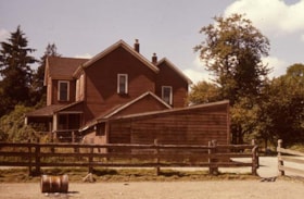
- Photograph of Lubbock's farm taken from Canada Way at Haszard Street. The Lubbock stable and farm house are both visible.
- Repository
- City of Burnaby Archives
- Date
- 1977
- Collection/Fonds
- Burnaby Historical Society fonds
- Subseries
- Lubbock family subseries
- Physical Description
- 1 photograph : col. ; 9 x 8.5 cm
- Description Level
- Item
- Record No.
- 289-001
- Access Restriction
- No restrictions
- Reproduction Restriction
- Reproduce for fair dealing purposes only
- Accession Number
- BHS1992-24
- Scope and Content
- Photograph of Lubbock's farm taken from Canada Way at Haszard Street. The Lubbock stable and farm house are both visible.
- Media Type
- Photograph
- Notes
- Title based on contents of photograph
- Geographic Access
- Grandview Highway
- Canada Way
- Burris Street
- Street Address
- 7803 Burris Street
- Historic Neighbourhood
- Burnaby Lake (Historic Neighbourhood)
- Planning Study Area
- Morley-Buckingham Area
Images

![Man carrying a boy on his shoulders, [190-] thumbnail](/media/hpo/_Data/_BVM_Images/1983/1983_0042_0064_001.jpg?width=280)
Man carrying a boy on his shoulders
https://search.heritageburnaby.ca/link/museumdescription324
- Repository
- Burnaby Village Museum
- Date
- [190-]
- Collection/Fonds
- Burnaby Village Museum Photograph collection
- Description Level
- Item
- Physical Description
- 1 photograph : b&w ; 8.5 x 5.7 cm
- Scope and Content
- Photograph of a man carrying a child on his shoulders in a field. The man and the child are both wearing hats, and they appear to be Asian. There are chickens feeding nearby them and trees in the background. The location is not identified.
- Repository
- Burnaby Village Museum
- Collection/Fonds
- Burnaby Village Museum Photograph collection
- Description Level
- Item
- Physical Description
- 1 photograph : b&w ; 8.5 x 5.7 cm
- Scope and Content
- Photograph of a man carrying a child on his shoulders in a field. The man and the child are both wearing hats, and they appear to be Asian. There are chickens feeding nearby them and trees in the background. The location is not identified.
- Subjects
- Agriculture - Farms
- Agriculture - Poultry
- Accession Code
- HV983.42.64
- Access Restriction
- No restrictions
- Reproduction Restriction
- No known restrictions
- Date
- [190-]
- Media Type
- Photograph
- Scan Resolution
- 600
- Scan Date
- 2023-09-26
- Notes
- Title based on contents of photograph
Images
![Man carrying a boy on his shoulders, [190-] thumbnail](/media/hpo/_Data/_BVM_Images/1983/1983_0042_0064_001.jpg)

Marine Drive Game Farm
https://search.heritageburnaby.ca/link/archivedescription35158
- Repository
- City of Burnaby Archives
- Date
- 1930 (date of original), copied 1986
- Collection/Fonds
- Burnaby Historical Society fonds
- Description Level
- Item
- Physical Description
- 1 photograph : b&w ; 12.7 x 17.8 cm print
- Scope and Content
- Photograph of the Marine Drive Game Farm, founded and owned by William "Bill" Greenslade's father, William Greenslade, Sr. It was located at 3295 Marine Drive (later renumbered 5421 Marine Drive).
- Repository
- City of Burnaby Archives
- Date
- 1930 (date of original), copied 1986
- Collection/Fonds
- Burnaby Historical Society fonds
- Subseries
- Pioneer Tales subseries
- Physical Description
- 1 photograph : b&w ; 12.7 x 17.8 cm print
- Description Level
- Item
- Record No.
- 204-015
- Access Restriction
- No restrictions
- Reproduction Restriction
- No known restrictions
- Accession Number
- BHS1988-03
- Scope and Content
- Photograph of the Marine Drive Game Farm, founded and owned by William "Bill" Greenslade's father, William Greenslade, Sr. It was located at 3295 Marine Drive (later renumbered 5421 Marine Drive).
- Names
- Marine Drive Game Farm
- Media Type
- Photograph
- Notes
- Title based on contents of photograph
- Geographic Access
- Marine Drive
- Street Address
- 5421 Marine Drive
- Historic Neighbourhood
- Fraser Arm (Historic Neighbourhood)
- Planning Study Area
- Clinton-Glenwood Area
Images

, copied 1978 thumbnail](/media/hpo/_Data/_BVM_Images/1978/1978_0001_0004_001.jpg?width=280)
Mayfield farm
https://search.heritageburnaby.ca/link/museumdescription450
- Repository
- Burnaby Village Museum
- Date
- [190-](date of original), copied 1978
- Collection/Fonds
- Burnaby Village Museum Photograph collection
- Description Level
- Item
- Physical Description
- 1 photograph : b&w ; 20.2 x 25.2 cm print
- Scope and Content
- Photograph of a two-storey farmhouse with a large patio, and a ladder on the roof. There is a foot path leading to the house through the garden, and a lake in the background. A catalogue record from 1978 indicates that the farmhouse depicted in the photograph is "Mayfield," the original farmhouse o…
- Repository
- Burnaby Village Museum
- Collection/Fonds
- Burnaby Village Museum Photograph collection
- Description Level
- Item
- Physical Description
- 1 photograph : b&w ; 20.2 x 25.2 cm print
- Scope and Content
- Photograph of a two-storey farmhouse with a large patio, and a ladder on the roof. There is a foot path leading to the house through the garden, and a lake in the background. A catalogue record from 1978 indicates that the farmhouse depicted in the photograph is "Mayfield," the original farmhouse of the Sprott family. The woman standing in the garden is identified as Mrs. Edgar Sprott, and the lake in the background is Burnaby Lake.
- Geographic Access
- Canada Way
- Burnaby Lake
- Accession Code
- HV978.1.4
- Access Restriction
- No restrictions
- Reproduction Restriction
- No known restrictions
- Date
- [190-](date of original), copied 1978
- Media Type
- Photograph
- Historic Neighbourhood
- Burnaby Lake (Historic Neighbourhood)
- Planning Study Area
- Morley-Buckingham Area
- Scan Resolution
- 600
- Scan Date
- 2023-07-25
- Notes
- Title based on contents of photograph
Images
, copied 1978 thumbnail](/media/hpo/_Data/_BVM_Images/1978/1978_0001_0004_001.jpg)

McKenzie family home
https://search.heritageburnaby.ca/link/archivedescription37034
- Repository
- City of Burnaby Archives
- Date
- 1912 (date of original), copied 1992
- Collection/Fonds
- Burnaby Historical Society fonds
- Description Level
- Item
- Physical Description
- 1 photograph : b&w ; 7.6 x 12.6 cm print
- Scope and Content
- Photograph of the McKenzie family home and farm on Laurier Street (now Halligan Street).
- Repository
- City of Burnaby Archives
- Date
- 1912 (date of original), copied 1992
- Collection/Fonds
- Burnaby Historical Society fonds
- Subseries
- Burnaby Centennial Anthology subseries
- Physical Description
- 1 photograph : b&w ; 7.6 x 12.6 cm print
- Description Level
- Item
- Record No.
- 315-497
- Access Restriction
- No restrictions
- Reproduction Restriction
- No known restrictions
- Accession Number
- BHS1994-04
- Scope and Content
- Photograph of the McKenzie family home and farm on Laurier Street (now Halligan Street).
- Media Type
- Photograph
- Notes
- Title based on contents of photograph
- Geographic Access
- Halligan Street
- Historic Neighbourhood
- Edmonds (Historic Neighbourhood)
- Planning Study Area
- Morley-Buckingham Area
Images


McKenzie family home
https://search.heritageburnaby.ca/link/archivedescription37039
- Repository
- City of Burnaby Archives
- Date
- 1912 (date of original), copied 1992
- Collection/Fonds
- Burnaby Historical Society fonds
- Description Level
- Item
- Physical Description
- 1 photograph : b&w ; 8.1 x 12.1 cm print
- Scope and Content
- Photograph of the McKenzie family home and farm on Laurier Street (now Halligan Street) with added rooms at the back and a strawberry patch in front.
- Repository
- City of Burnaby Archives
- Date
- 1912 (date of original), copied 1992
- Collection/Fonds
- Burnaby Historical Society fonds
- Subseries
- Burnaby Centennial Anthology subseries
- Physical Description
- 1 photograph : b&w ; 8.1 x 12.1 cm print
- Description Level
- Item
- Record No.
- 315-502
- Access Restriction
- No restrictions
- Reproduction Restriction
- No known restrictions
- Accession Number
- BHS1994-04
- Scope and Content
- Photograph of the McKenzie family home and farm on Laurier Street (now Halligan Street) with added rooms at the back and a strawberry patch in front.
- Media Type
- Photograph
- Notes
- Title based on contents of photograph
- Geographic Access
- Halligan Street
- Historic Neighbourhood
- Edmonds (Historic Neighbourhood)
- Planning Study Area
- Morley-Buckingham Area
Images


McKenzie family home and farm
https://search.heritageburnaby.ca/link/archivedescription37035
- Repository
- City of Burnaby Archives
- Date
- 1912 (date of original), copied 1992
- Collection/Fonds
- Burnaby Historical Society fonds
- Description Level
- Item
- Physical Description
- 1 photograph : b&w ; 8.6 x 12.7 cm print
- Scope and Content
- Photograph of the McKenzie family home and farm on Laurier Street (now Halligan Street). Cows can be seen in the background and a girl in the foreground.
- Repository
- City of Burnaby Archives
- Date
- 1912 (date of original), copied 1992
- Collection/Fonds
- Burnaby Historical Society fonds
- Subseries
- Burnaby Centennial Anthology subseries
- Physical Description
- 1 photograph : b&w ; 8.6 x 12.7 cm print
- Description Level
- Item
- Record No.
- 315-498
- Access Restriction
- No restrictions
- Reproduction Restriction
- No known restrictions
- Accession Number
- BHS1994-04
- Scope and Content
- Photograph of the McKenzie family home and farm on Laurier Street (now Halligan Street). Cows can be seen in the background and a girl in the foreground.
- Media Type
- Photograph
- Notes
- Title based on contents of photograph
- Geographic Access
- Halligan Street
- Historic Neighbourhood
- Edmonds (Historic Neighbourhood)
- Planning Study Area
- Morley-Buckingham Area
Images

![McKenzie family home and farm, [192-?] (date of original), copied 1992 thumbnail](/media/hpo/_Data/_Archives_Images/_Unrestricted/315/315-505.jpg?width=280)
McKenzie family home and farm
https://search.heritageburnaby.ca/link/archivedescription37042
- Repository
- City of Burnaby Archives
- Date
- [192-?] (date of original), copied 1992
- Collection/Fonds
- Burnaby Historical Society fonds
- Description Level
- Item
- Physical Description
- 1 photograph : b&w ; 8.8 x 12.7 cm print
- Scope and Content
- Photograph of the McKenzie family home and farm on Laurier Street (now Halligan Street).
- Repository
- City of Burnaby Archives
- Date
- [192-?] (date of original), copied 1992
- Collection/Fonds
- Burnaby Historical Society fonds
- Subseries
- Burnaby Centennial Anthology subseries
- Physical Description
- 1 photograph : b&w ; 8.8 x 12.7 cm print
- Description Level
- Item
- Record No.
- 315-505
- Access Restriction
- No restrictions
- Reproduction Restriction
- No known restrictions
- Accession Number
- BHS1994-04
- Scope and Content
- Photograph of the McKenzie family home and farm on Laurier Street (now Halligan Street).
- Media Type
- Photograph
- Notes
- Title based on contents of photograph
- Geographic Access
- Halligan Street
- Historic Neighbourhood
- Edmonds (Historic Neighbourhood)
- Planning Study Area
- Morley-Buckingham Area
Images
![McKenzie family home and farm, [192-?] (date of original), copied 1992 thumbnail](/media/hpo/_Data/_Archives_Images/_Unrestricted/315/315-505.jpg)
![Money's Mushrooms parade float, [1957] (date of original), digitally copied 2013 thumbnail](/media/hpo/_Data/_Archives_Images/_Unrestricted/550/552-003.jpg?width=280)
Money's Mushrooms parade float
https://search.heritageburnaby.ca/link/archivedescription77189
- Repository
- City of Burnaby Archives
- Date
- [1957] (date of original), digitally copied 2013
- Collection/Fonds
- Stiglish family fonds
- Description Level
- Item
- Physical Description
- 1 photograph : b&w copy-print ; 9 x 9 cm
- Scope and Content
- Photograph of the Money's Mushrooms parade float that FJ "Jack" Stiglish created for the Pacific National Exhibition (PNE) parade. Helen Stiglish is believed to have created the mushroom drawings for the float.
- Repository
- City of Burnaby Archives
- Date
- [1957] (date of original), digitally copied 2013
- Collection/Fonds
- Stiglish family fonds
- Physical Description
- 1 photograph : b&w copy-print ; 9 x 9 cm
- Description Level
- Item
- Record No.
- 552-003
- Access Restriction
- No restrictions
- Reproduction Restriction
- Reproduce for fair dealing purposes only
- Accession Number
- 2013-07
- Scope and Content
- Photograph of the Money's Mushrooms parade float that FJ "Jack" Stiglish created for the Pacific National Exhibition (PNE) parade. Helen Stiglish is believed to have created the mushroom drawings for the float.
- Media Type
- Photograph
- Notes
- Title based on contents of photograph
- Note in blue ink on verso of photograph reads: "Father created the float for the PNE parade with mother's help. My mother probably drew the mushrooms as she was very artistic. There was also a booth at the PNE that / about 1957 / float on an old red Studebaker"
- Original spelling of surname was "Stiglich"
- Geographic Access
- Keswick Avenue
- Street Address
- 3782 Keswick Avenue
- Historic Neighbourhood
- Burquitlam (Historic Neighbourhood)
- Planning Study Area
- Cameron Area
Images
![Money's Mushrooms parade float, [1957] (date of original), digitally copied 2013 thumbnail](/media/hpo/_Data/_Archives_Images/_Unrestricted/550/552-003.jpg)
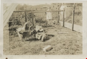
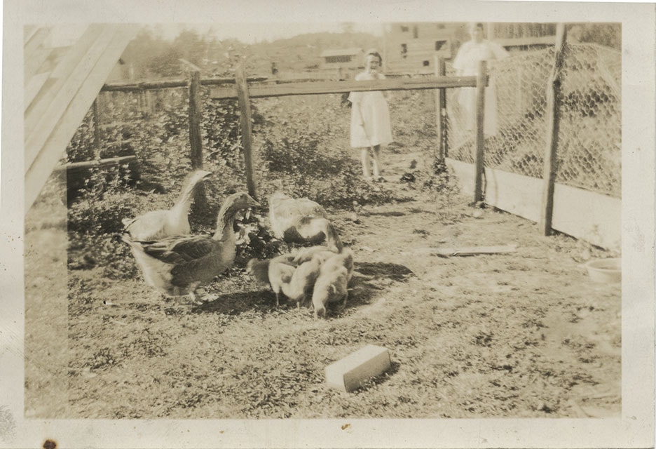
Mrs. Cowan and daughter
https://search.heritageburnaby.ca/link/museumdescription165
- Repository
- Burnaby Village Museum
- Date
- February 24, 1923
- Collection/Fonds
- Burnaby Village Museum Photograph collection
- Description Level
- Item
- Physical Description
- 1 photograph : b&w ; 7.1 x 10.3 cm
- Scope and Content
- Photograph of a woman and a girl standing by a chickenwire fence, looking at the geese and chicks. Vegetable gardens and a log building can be seen as well. According to the note in the accession file, the woman is Mrs. Sylvia Cowan, the second wife of Mr. James Cowan since they were married in 1…
- Repository
- Burnaby Village Museum
- Collection/Fonds
- Burnaby Village Museum Photograph collection
- Description Level
- Item
- Physical Description
- 1 photograph : b&w ; 7.1 x 10.3 cm
- Scope and Content
- Photograph of a woman and a girl standing by a chickenwire fence, looking at the geese and chicks. Vegetable gardens and a log building can be seen as well. According to the note in the accession file, the woman is Mrs. Sylvia Cowan, the second wife of Mr. James Cowan since they were married in 1922, and the girl is one of Mr. Cowan's two daughters from his first marriage. The property depicted in the photograph was at 2930 Gilpin Street (later renumbered 5926 Gilpin Street), where Mr. Cowan purchased two acres of land to build a home in 1919. After settling in Burnaby in 1923 at that property, Mr. Cowan became active in serving the community, eventually earning the honour of having a memorial hall named after him, which later changed to the James Cowan Theatre. An annotation on the back of the photo reads: "2930 Gilpin in 1923/24 / 2 acres, vegetable gardens, chickens, a cow, geese / more info in files / Cowan Property." Stamped on the back of the photo: "0110."
- Subjects
- Animals - Fowl
- Agriculture - Farms
- Names
- Cowan, Sylvia
- Geographic Access
- Gilpin Street
- Street Address
- 5926 Gilpin Street
- Accession Code
- BV985.31.6
- Access Restriction
- No restrictions
- Reproduction Restriction
- No known restrictions
- Date
- February 24, 1923
- Media Type
- Photograph
- Historic Neighbourhood
- Burnaby Lake (Historic Neighbourhood)
- Planning Study Area
- Douglas-Gilpin Area
- Scan Resolution
- 600
- Scan Date
- 2023-12-19
- Notes
- Title based on contents of photograph
Images
![Mushroom farm houses, [196-] (date of original), digitally copied 2013 thumbnail](/media/hpo/_Data/_Archives_Images/_Unrestricted/550/552-002.jpg?width=280)
Mushroom farm houses
https://search.heritageburnaby.ca/link/archivedescription77188
- Repository
- City of Burnaby Archives
- Date
- [196-] (date of original), digitally copied 2013
- Collection/Fonds
- Stiglish family fonds
- Description Level
- Item
- Physical Description
- 1 photograph : b&w copy-print ; 9 x 9 cm
- Scope and Content
- Photograph of the mushroom farm houses on the Stiglish family property (this property included the F.J. Stiglish mushroom farm).
- Repository
- City of Burnaby Archives
- Date
- [196-] (date of original), digitally copied 2013
- Collection/Fonds
- Stiglish family fonds
- Physical Description
- 1 photograph : b&w copy-print ; 9 x 9 cm
- Description Level
- Item
- Record No.
- 552-002
- Access Restriction
- No restrictions
- Reproduction Restriction
- Reproduce for fair dealing purposes only
- Accession Number
- 2013-07
- Scope and Content
- Photograph of the mushroom farm houses on the Stiglish family property (this property included the F.J. Stiglish mushroom farm).
- Subjects
- Agriculture - Farms
- Names
- Stiglish, F.J. "Jack"
- Media Type
- Photograph
- Notes
- Title based on contents of photograph
- Note in blue ink on verso of photograph reads: "mushroom farm houses / F.J. Stiglish mushroom farm / 3782 Keswick Ave / Burnaby 3 / previous 1050 Keswick Ave /1960s"
- Original spelling of surname was "Stiglich"
- Geographic Access
- Keswick Avenue
- Street Address
- 3782 Keswick Avenue
- Historic Neighbourhood
- Burquitlam (Historic Neighbourhood)
- Planning Study Area
- Cameron Area
Images
![Mushroom farm houses, [196-] (date of original), digitally copied 2013 thumbnail](/media/hpo/_Data/_Archives_Images/_Unrestricted/550/552-002.jpg)
![Newton Farm, [1935] thumbnail](/media/hpo/_Data/_Archives_Images/_Unrestricted/600/625-037.jpg?width=280)
Newton Farm
https://search.heritageburnaby.ca/link/archivedescription95965
- Repository
- City of Burnaby Archives
- Date
- [1935]
- Collection/Fonds
- City of Burnaby Archives photograph collection
- Description Level
- Item
- Physical Description
- 1 photograph (tiff) : b&w
- Scope and Content
- Photograph of Newton Farm, located at Patterson Avenue and Marine Drive.
- Repository
- City of Burnaby Archives
- Date
- [1935]
- Collection/Fonds
- City of Burnaby Archives photograph collection
- Physical Description
- 1 photograph (tiff) : b&w
- Description Level
- Item
- Record No.
- 625-037
- Access Restriction
- No restrictions
- Reproduction Restriction
- No known restrictions
- Accession Number
- 2013-31
- Scope and Content
- Photograph of Newton Farm, located at Patterson Avenue and Marine Drive.
- Subjects
- Agriculture - Farms
- Media Type
- Photograph
- Notes
- Title based on content of photograph
- Geographic Access
- Patterson Avenue
- Marine Drive
- Historic Neighbourhood
- Fraser Arm (Historic Neighbourhood)
Images
![Newton Farm, [1935] thumbnail](/media/hpo/_Data/_Archives_Images/_Unrestricted/600/625-037.jpg)
![Nicholson farm, [1921] thumbnail](/media/hpo/_Data/_Archives_Images/_Unrestricted/371/375-003.jpg?width=280)
Nicholson farm
https://search.heritageburnaby.ca/link/archivedescription38242
- Repository
- City of Burnaby Archives
- Date
- [1921]
- Collection/Fonds
- Burnaby Historical Society fonds
- Description Level
- Item
- Physical Description
- 1 photograph : b&w ; 9 x 12.5 cm
- Scope and Content
- Photograph of four men standing alongside a team of horses working in the field at the farm belonging to E.W. Nicholson. The house and barns can be seen in the background.
- Repository
- City of Burnaby Archives
- Date
- [1921]
- Collection/Fonds
- Burnaby Historical Society fonds
- Subseries
- Margaret McCallum subseries
- Physical Description
- 1 photograph : b&w ; 9 x 12.5 cm
- Description Level
- Item
- Record No.
- 375-003
- Access Restriction
- No restrictions
- Reproduction Restriction
- No known restrictions
- Accession Number
- BHS1986-42
- Scope and Content
- Photograph of four men standing alongside a team of horses working in the field at the farm belonging to E.W. Nicholson. The house and barns can be seen in the background.
- Media Type
- Photograph
- Notes
- Title based on contents of photograph
- Geographic Access
- Boundary Road
- Street Address
- 2550 Boundary Road
- Historic Neighbourhood
- Broadview (Historic Neighbourhood)
- Planning Study Area
- West Central Valley Area
Images
![Nicholson farm, [1921] thumbnail](/media/hpo/_Data/_Archives_Images/_Unrestricted/371/375-003.jpg)

Nicholson Farm
https://search.heritageburnaby.ca/link/archivedescription38255
- Repository
- City of Burnaby Archives
- Date
- 1910
- Collection/Fonds
- Burnaby Historical Society fonds
- Description Level
- Item
- Physical Description
- 1 photograph : b&w ; 10.2 x 15.2 cm
- Scope and Content
- Photograph of the home and barns at the farm of E.W. Nicholson and Elsie Nicholson.
- Repository
- City of Burnaby Archives
- Date
- 1910
- Collection/Fonds
- Burnaby Historical Society fonds
- Subseries
- Margaret McCallum subseries
- Physical Description
- 1 photograph : b&w ; 10.2 x 15.2 cm
- Description Level
- Item
- Record No.
- 375-017
- Access Restriction
- No restrictions
- Reproduction Restriction
- No known restrictions
- Accession Number
- BHS1986-42
- Scope and Content
- Photograph of the home and barns at the farm of E.W. Nicholson and Elsie Nicholson.
- Media Type
- Photograph
- Notes
- Title based on contents of photograph
- A note on the back of the photograph reads: "Home of E.W. Nicholson 1900-1951 and Elsie Nicholson 1934-1951. Boundary Road and Great Northern Railway. Property sold to Link-Belt Co. in 1951."
- Geographic Access
- Boundary Road
- Street Address
- 2550 Boundary Road
- Historic Neighbourhood
- Broadview (Historic Neighbourhood)
- Planning Study Area
- West Central Valley Area
Images


Nicholson Farm
https://search.heritageburnaby.ca/link/archivedescription38258
- Repository
- City of Burnaby Archives
- Date
- 1933
- Collection/Fonds
- Burnaby Historical Society fonds
- Description Level
- Item
- Physical Description
- 1 photograph : b&w ; 10.5 x 15.5 cm
- Scope and Content
- Photograph looking over a field toward a house and barn identified as E.W. Nicholson's Broadway Jersey Ranch.
- Repository
- City of Burnaby Archives
- Date
- 1933
- Collection/Fonds
- Burnaby Historical Society fonds
- Subseries
- Margaret McCallum subseries
- Physical Description
- 1 photograph : b&w ; 10.5 x 15.5 cm
- Description Level
- Item
- Record No.
- 375-020
- Access Restriction
- No restrictions
- Reproduction Restriction
- No known restrictions
- Accession Number
- BHS1986-42
- Scope and Content
- Photograph looking over a field toward a house and barn identified as E.W. Nicholson's Broadway Jersey Ranch.
- Subjects
- Agriculture - Farms
- Buildings - Agricultural - Barns
- Agriculture - Crops
- Buildings - Residential - Houses
- Media Type
- Photograph
- Notes
- Title based on caption
- A note on the back of the photograph reads: "Our farm home - Broadway Jersey Ranch 1993. 3704 Boundary Road at G.N.Ry Crossing Burnaby BC. Property occupied and owned by E.W. Nicholson from May 23, 1900 to Sept. 29, 1951. Property sold to Link-Belt Co. in 1951."
- Geographic Access
- Boundary Road
- Street Address
- 2550 Boundary Road
- Historic Neighbourhood
- Broadview (Historic Neighbourhood)
- Planning Study Area
- West Central Valley Area
Images

![North Arm Dairy, [1905] thumbnail](/media/hpo/_Data/_Archives_Images/_Unrestricted/251/275-005.jpg?width=280)
North Arm Dairy
https://search.heritageburnaby.ca/link/archivedescription36473
- Repository
- City of Burnaby Archives
- Date
- [1905]
- Collection/Fonds
- Burnaby Historical Society fonds
- Description Level
- Item
- Physical Description
- 1 photograph : b&w ; 8.5 x 12.5 cm print
- Scope and Content
- Photograph of the North Arm Dairy, the Thrussell farm and family business. Half a dozen cows are walking towards the barn as the children mingle around them. The large barn is in the center, and the North Arm Dairy wagon is visible in the background.
- Repository
- City of Burnaby Archives
- Date
- [1905]
- Collection/Fonds
- Burnaby Historical Society fonds
- Subseries
- Thrussell family subseries
- Physical Description
- 1 photograph : b&w ; 8.5 x 12.5 cm print
- Description Level
- Item
- Record No.
- 275-005
- Access Restriction
- No restrictions
- Reproduction Restriction
- No known restrictions
- Accession Number
- BHS1992-05
- Scope and Content
- Photograph of the North Arm Dairy, the Thrussell farm and family business. Half a dozen cows are walking towards the barn as the children mingle around them. The large barn is in the center, and the North Arm Dairy wagon is visible in the background.
- Subjects
- Agriculture - Farms
- Animals - Cows
- Names
- North Arm Dairy
- Media Type
- Photograph
- Notes
- Title based on contents of photograph
- Geographic Access
- Marine Drive
- Nelson Avenue
- Historic Neighbourhood
- Fraser Arm (Historic Neighbourhood)
- Planning Study Area
- Big Bend Area
Images
![North Arm Dairy, [1905] thumbnail](/media/hpo/_Data/_Archives_Images/_Unrestricted/251/275-005.jpg)
![North Arm Dairy, [1905] thumbnail](/media/hpo/_Data/_Archives_Images/_Unrestricted/251/275-006.jpg?width=280)
North Arm Dairy
https://search.heritageburnaby.ca/link/archivedescription36474
- Repository
- City of Burnaby Archives
- Date
- [1905]
- Collection/Fonds
- Burnaby Historical Society fonds
- Description Level
- Item
- Physical Description
- 1 photograph : b&w ; 8.5 x 12.5 cm print
- Scope and Content
- Photograph of the North Arm Dairy, the Thrussell farm and family business. The family is standing in front of the garage that houses the North Arm Diary wagon. The younger Frederick is standing with his arm across his brow, blocking the sun. His two sisters Ethel and Mary Anne are beside him. Eva i…
- Repository
- City of Burnaby Archives
- Date
- [1905]
- Collection/Fonds
- Burnaby Historical Society fonds
- Subseries
- Thrussell family subseries
- Physical Description
- 1 photograph : b&w ; 8.5 x 12.5 cm print
- Description Level
- Item
- Record No.
- 275-006
- Access Restriction
- No restrictions
- Reproduction Restriction
- No known restrictions
- Accession Number
- BHS1992-05
- Scope and Content
- Photograph of the North Arm Dairy, the Thrussell farm and family business. The family is standing in front of the garage that houses the North Arm Diary wagon. The younger Frederick is standing with his arm across his brow, blocking the sun. His two sisters Ethel and Mary Anne are beside him. Eva is standing beside her mother Harriett, who has baby Edith in her arms. The elder Frederick is standing front and center. Another man stands off to the right. In the distance, half a dozen cows are walking towards the barn.
- Subjects
- Agriculture - Farms
- Animals - Cows
- Names
- North Arm Dairy
- Thrussell, Frederick T.
- Thrussell, Ethel
- Welsh, Mary Anne "Annie" Thrussell Phillips
- Thrussell, Eva
- Thrussell, Harriett Fenwick
- Cleghorn, Edith Thrussell
- Thrussell, Fredrick (1869-1909)
- Media Type
- Photograph
- Notes
- Title based on contents of photograph
- Geographic Access
- Marine Drive
- Nelson Avenue
- Historic Neighbourhood
- Fraser Arm (Historic Neighbourhood)
- Planning Study Area
- Big Bend Area
Images
![North Arm Dairy, [1905] thumbnail](/media/hpo/_Data/_Archives_Images/_Unrestricted/251/275-006.jpg)
![North Arm Dairy, [1907] thumbnail](/media/hpo/_Data/_Archives_Images/_Unrestricted/251/275-007.jpg?width=280)
North Arm Dairy
https://search.heritageburnaby.ca/link/archivedescription36475
- Repository
- City of Burnaby Archives
- Date
- [1907]
- Collection/Fonds
- Burnaby Historical Society fonds
- Description Level
- Item
- Physical Description
- 1 photograph : b&w ; 8.5 x 12.5 cm print
- Scope and Content
- Photograph of the North Arm Dairy, the Thrussell farm and family business. A young child is sitting on one of the horses that is harnessed to the dairy wagon. The other horse has no rider, but a girl is holding on to the riens and sitting in the dairy wagon. A man is standing beside the horse with …
- Repository
- City of Burnaby Archives
- Date
- [1907]
- Collection/Fonds
- Burnaby Historical Society fonds
- Subseries
- Thrussell family subseries
- Physical Description
- 1 photograph : b&w ; 8.5 x 12.5 cm print
- Description Level
- Item
- Record No.
- 275-007
- Access Restriction
- No restrictions
- Reproduction Restriction
- No known restrictions
- Accession Number
- BHS1992-05
- Scope and Content
- Photograph of the North Arm Dairy, the Thrussell farm and family business. A young child is sitting on one of the horses that is harnessed to the dairy wagon. The other horse has no rider, but a girl is holding on to the riens and sitting in the dairy wagon. A man is standing beside the horse with the rider, holding his reins. Two cows are standing in front of the barn, along with a woman who is holding a child in her arms.
- Names
- North Arm Dairy
- Media Type
- Photograph
- Notes
- Title based on contents of photograph
- Geographic Access
- Marine Drive
- Nelson Avenue
- Historic Neighbourhood
- Fraser Arm (Historic Neighbourhood)
- Planning Study Area
- Big Bend Area
Images
![North Arm Dairy, [1907] thumbnail](/media/hpo/_Data/_Archives_Images/_Unrestricted/251/275-007.jpg)

Oakalla Barn
https://search.heritageburnaby.ca/link/archivedescription38298
- Repository
- City of Burnaby Archives
- Date
- 1985
- Collection/Fonds
- Burnaby Historical Society fonds
- Description Level
- Item
- Physical Description
- 1 photograph : b&w ; 12.7 x 17.5 cm
- Scope and Content
- Photograph of the barn and silo at Oakalla Prison Farm.
- Repository
- City of Burnaby Archives
- Date
- 1985
- Collection/Fonds
- Burnaby Historical Society fonds
- Subseries
- Photographs subseries
- Physical Description
- 1 photograph : b&w ; 12.7 x 17.5 cm
- Description Level
- Item
- Record No.
- 398-005
- Access Restriction
- No restrictions
- Reproduction Restriction
- Reproduce for fair dealing purposes only
- Accession Number
- BHS2007-04
- Scope and Content
- Photograph of the barn and silo at Oakalla Prison Farm.
- Subjects
- Buildings - Agricultural - Barns
- Agriculture - Farms
- Buildings - Public - Detention Facilities
- Names
- Oakalla Prison Farm
- Media Type
- Photograph
- Notes
- Title based on contents of photograph
- Geographic Access
- Oakmount Crescent
- Street Address
- 5220 Oakmount Crescent
- Historic Neighbourhood
- Burnaby Lake (Historic Neighbourhood)
- Planning Study Area
- Oakalla Area
Images

![Oakalla Prison farm, [195-] (date of original), copied 1985 thumbnail](/media/hpo/_Data/_Archives_Images/_Unrestricted/126/134-009.jpg?width=280)
Oakalla Prison farm
https://search.heritageburnaby.ca/link/archivedescription34793
- Repository
- City of Burnaby Archives
- Date
- [195-] (date of original), copied 1985
- Collection/Fonds
- Burnaby Historical Society fonds
- Description Level
- Item
- Physical Description
- 1 photograph : b&w ; 8.8 x 12.0 cm print
- Scope and Content
- Photograph of the exterior of farm buildings and the road to the equipment shed at Oakalla Prison Farm.
- Repository
- City of Burnaby Archives
- Date
- [195-] (date of original), copied 1985
- Collection/Fonds
- Burnaby Historical Society fonds
- Physical Description
- 1 photograph : b&w ; 8.8 x 12.0 cm print
- Description Level
- Item
- Record No.
- 134-009
- Access Restriction
- No restrictions
- Reproduction Restriction
- Reproduce for fair dealing purposes only
- Accession Number
- BHS1985-02
- Scope and Content
- Photograph of the exterior of farm buildings and the road to the equipment shed at Oakalla Prison Farm.
- Names
- Oakalla Prison Farm
- Media Type
- Photograph
- Notes
- Title based on contents of photograph
- Geographic Access
- Oakmount Crescent
- Street Address
- 5220 Oakmount Crescent
- Historic Neighbourhood
- Burnaby Lake (Historic Neighbourhood)
- Planning Study Area
- Oakalla Area
Images
![Oakalla Prison farm, [195-] (date of original), copied 1985 thumbnail](/media/hpo/_Data/_Archives_Images/_Unrestricted/126/134-009.jpg)
![Oakalla Prison Farm, [195-] (date of original), copied 1985 thumbnail](/media/hpo/_Data/_Archives_Images/_Unrestricted/126/134-012.jpg?width=280)
Oakalla Prison Farm
https://search.heritageburnaby.ca/link/archivedescription34796
- Repository
- City of Burnaby Archives
- Date
- [195-] (date of original), copied 1985
- Collection/Fonds
- Burnaby Historical Society fonds
- Description Level
- Item
- Physical Description
- 1 photograph : b&w ; 8.8 x 12.1 cm print
- Scope and Content
- Photograph of the exterior of farm buildings and the shop/repairs buildings at Oakalla Prison Farm.
- Repository
- City of Burnaby Archives
- Date
- [195-] (date of original), copied 1985
- Collection/Fonds
- Burnaby Historical Society fonds
- Physical Description
- 1 photograph : b&w ; 8.8 x 12.1 cm print
- Description Level
- Item
- Record No.
- 134-012
- Access Restriction
- No restrictions
- Reproduction Restriction
- Reproduce for fair dealing purposes only
- Accession Number
- BHS1985-02
- Scope and Content
- Photograph of the exterior of farm buildings and the shop/repairs buildings at Oakalla Prison Farm.
- Names
- Oakalla Prison Farm
- Media Type
- Photograph
- Notes
- Title based on contents of photograph
- Geographic Access
- Oakmount Crescent
- Street Address
- 5220 Oakmount Crescent
- Historic Neighbourhood
- Burnaby Lake (Historic Neighbourhood)
- Planning Study Area
- Oakalla Area
Images
![Oakalla Prison Farm, [195-] (date of original), copied 1985 thumbnail](/media/hpo/_Data/_Archives_Images/_Unrestricted/126/134-012.jpg)
![Oakalla Prison Farm, [195-] (date of original), copied 1985 thumbnail](/media/hpo/_Data/_Archives_Images/_Unrestricted/126/134-013.jpg?width=280)
Oakalla Prison Farm
https://search.heritageburnaby.ca/link/archivedescription34797
- Repository
- City of Burnaby Archives
- Date
- [195-] (date of original), copied 1985
- Collection/Fonds
- Burnaby Historical Society fonds
- Description Level
- Item
- Physical Description
- 1 photograph : b&w ; 8.8 x 12.6 cm print
- Scope and Content
- Photograph of the exterior of farm buildings and the equipment shed at Oakalla Prison Farm.
- Repository
- City of Burnaby Archives
- Date
- [195-] (date of original), copied 1985
- Collection/Fonds
- Burnaby Historical Society fonds
- Physical Description
- 1 photograph : b&w ; 8.8 x 12.6 cm print
- Description Level
- Item
- Record No.
- 134-013
- Access Restriction
- No restrictions
- Reproduction Restriction
- Reproduce for fair dealing purposes only
- Accession Number
- BHS1985-02
- Scope and Content
- Photograph of the exterior of farm buildings and the equipment shed at Oakalla Prison Farm.
- Names
- Oakalla Prison Farm
- Media Type
- Photograph
- Notes
- Title based on contents of photograph
- Geographic Access
- Oakmount Crescent
- Street Address
- 5220 Oakmount Crescent
- Historic Neighbourhood
- Burnaby Lake (Historic Neighbourhood)
- Planning Study Area
- Oakalla Area
Images
![Oakalla Prison Farm, [195-] (date of original), copied 1985 thumbnail](/media/hpo/_Data/_Archives_Images/_Unrestricted/126/134-013.jpg)
![Oakalla Prison Farm, [195-] (date of original), copied 1985 thumbnail](/media/hpo/_Data/_Archives_Images/_Unrestricted/126/134-015.jpg?width=280)
Oakalla Prison Farm
https://search.heritageburnaby.ca/link/archivedescription34799
- Repository
- City of Burnaby Archives
- Date
- [195-] (date of original), copied 1985
- Collection/Fonds
- Burnaby Historical Society fonds
- Description Level
- Item
- Physical Description
- 1 photograph : b&w ; 8.8 x 11.9 cm print
- Scope and Content
- Photograph of Oakalla Prison Farm taken from the main building and looking northeast.
- Repository
- City of Burnaby Archives
- Date
- [195-] (date of original), copied 1985
- Collection/Fonds
- Burnaby Historical Society fonds
- Physical Description
- 1 photograph : b&w ; 8.8 x 11.9 cm print
- Description Level
- Item
- Record No.
- 134-015
- Access Restriction
- No restrictions
- Reproduction Restriction
- Reproduce for fair dealing purposes only
- Accession Number
- BHS1985-02
- Scope and Content
- Photograph of Oakalla Prison Farm taken from the main building and looking northeast.
- Names
- Oakalla Prison Farm
- Media Type
- Photograph
- Notes
- Title based on contents of photograph
- Geographic Access
- Oakmount Crescent
- Street Address
- 5220 Oakmount Crescent
- Historic Neighbourhood
- Burnaby Lake (Historic Neighbourhood)
- Planning Study Area
- Oakalla Area
Images
![Oakalla Prison Farm, [195-] (date of original), copied 1985 thumbnail](/media/hpo/_Data/_Archives_Images/_Unrestricted/126/134-015.jpg)
![Oakalla Prison Farm, [195-] (date of original), copied 1985 thumbnail](/media/hpo/_Data/_Archives_Images/_Unrestricted/126/134-016.jpg?width=280)
Oakalla Prison Farm
https://search.heritageburnaby.ca/link/archivedescription34800
- Repository
- City of Burnaby Archives
- Date
- [195-] (date of original), copied 1985
- Collection/Fonds
- Burnaby Historical Society fonds
- Description Level
- Item
- Physical Description
- 1 photograph : b&w ; 8.8 x 12.0 cm
- Scope and Content
- Photograph of Oakalla Prison Farm taken from the main building and looking northeast. Deer Lake can be seen in the background.
- Repository
- City of Burnaby Archives
- Date
- [195-] (date of original), copied 1985
- Collection/Fonds
- Burnaby Historical Society fonds
- Physical Description
- 1 photograph : b&w ; 8.8 x 12.0 cm
- Description Level
- Item
- Record No.
- 134-016
- Access Restriction
- No restrictions
- Reproduction Restriction
- Reproduce for fair dealing purposes only
- Accession Number
- BHS1985-02
- Scope and Content
- Photograph of Oakalla Prison Farm taken from the main building and looking northeast. Deer Lake can be seen in the background.
- Subjects
- Agriculture - Farms
- Buildings - Public - Detention Facilities
- Geographic Features - Lakes and Ponds
- Names
- Oakalla Prison Farm
- Media Type
- Photograph
- Notes
- Title based on contents of photograph
- Geographic Access
- Deer Lake
- Oakmount Crescent
- Street Address
- 5220 Oakmount Crescent
- Historic Neighbourhood
- Burnaby Lake (Historic Neighbourhood)
- Planning Study Area
- Oakalla Area
Images
![Oakalla Prison Farm, [195-] (date of original), copied 1985 thumbnail](/media/hpo/_Data/_Archives_Images/_Unrestricted/126/134-016.jpg)
![Oakalla Prison Farm, [195-] (date of original), copied 1985 thumbnail](/media/hpo/_Data/_Archives_Images/_Unrestricted/126/134-017.jpg?width=280)
Oakalla Prison Farm
https://search.heritageburnaby.ca/link/archivedescription34801
- Repository
- City of Burnaby Archives
- Date
- [195-] (date of original), copied 1985
- Collection/Fonds
- Burnaby Historical Society fonds
- Description Level
- Item
- Physical Description
- 1 photograph : b&w ; 8.8 x 12.2 cm
- Scope and Content
- Photograph of Oakalla Prison Farm taken from the main building and looking southeast. Deer Lake can be seen in the background.
- Repository
- City of Burnaby Archives
- Date
- [195-] (date of original), copied 1985
- Collection/Fonds
- Burnaby Historical Society fonds
- Physical Description
- 1 photograph : b&w ; 8.8 x 12.2 cm
- Description Level
- Item
- Record No.
- 134-017
- Access Restriction
- No restrictions
- Reproduction Restriction
- Reproduce for fair dealing purposes only
- Accession Number
- BHS1985-02
- Scope and Content
- Photograph of Oakalla Prison Farm taken from the main building and looking southeast. Deer Lake can be seen in the background.
- Subjects
- Agriculture - Farms
- Buildings - Public - Detention Facilities
- Geographic Features - Lakes and Ponds
- Names
- Oakalla Prison Farm
- Media Type
- Photograph
- Notes
- Title based on contents of photograph
- Geographic Access
- Deer Lake
- Oakmount Crescent
- Street Address
- 5220 Oakmount Crescent
- Historic Neighbourhood
- Burnaby Lake (Historic Neighbourhood)
- Planning Study Area
- Oakalla Area
Images
![Oakalla Prison Farm, [195-] (date of original), copied 1985 thumbnail](/media/hpo/_Data/_Archives_Images/_Unrestricted/126/134-017.jpg)
![Oakalla Prison Farm, [195-] (date of original), copied 1985 thumbnail](/media/hpo/_Data/_Archives_Images/_Unrestricted/126/134-018.jpg?width=280)
Oakalla Prison Farm
https://search.heritageburnaby.ca/link/archivedescription34802
- Repository
- City of Burnaby Archives
- Date
- [195-] (date of original), copied 1985
- Collection/Fonds
- Burnaby Historical Society fonds
- Description Level
- Item
- Physical Description
- 1 photograph : b&w ; 8.8 x 12.0 cm
- Scope and Content
- Photograph of Oakalla Prison Farm taken from the main building and looking southeast. Deer Lake can be seen in the background.
- Repository
- City of Burnaby Archives
- Date
- [195-] (date of original), copied 1985
- Collection/Fonds
- Burnaby Historical Society fonds
- Physical Description
- 1 photograph : b&w ; 8.8 x 12.0 cm
- Description Level
- Item
- Record No.
- 134-018
- Access Restriction
- No restrictions
- Reproduction Restriction
- Reproduce for fair dealing purposes only
- Accession Number
- BHS1985-02
- Scope and Content
- Photograph of Oakalla Prison Farm taken from the main building and looking southeast. Deer Lake can be seen in the background.
- Subjects
- Agriculture - Farms
- Buildings - Public - Detention Facilities
- Geographic Features - Lakes and Ponds
- Names
- Oakalla Prison Farm
- Media Type
- Photograph
- Notes
- Title based on contents of photograph
- Geographic Access
- Deer Lake
- Oakmount Crescent
- Street Address
- 5220 Oakmount Crescent
- Historic Neighbourhood
- Burnaby Lake (Historic Neighbourhood)
- Planning Study Area
- Oakalla Area
Images
![Oakalla Prison Farm, [195-] (date of original), copied 1985 thumbnail](/media/hpo/_Data/_Archives_Images/_Unrestricted/126/134-018.jpg)