Forest Lawn Memorial Park
https://search.heritageburnaby.ca/link/landmark579
- Repository
- Burnaby Heritage Planning
- Description
- Cemetery site.
- Associated Dates
- 1935
- Street View URL
- Google Maps Street View
- Repository
- Burnaby Heritage Planning
- Geographic Access
- Royal Oak Avenue
- Associated Dates
- 1935
- Description
- Cemetery site.
- Heritage Value
- Forest Lawn Memorial Park was founded and designed by Albert F. Arnold, who wanted to design a memorial park “which would be a place of perpetual beauty and which would banish the ‘graveyard’ taint from such places forever.” The 145 acres of Forest Lawn were designed as a garden, which overlooks Vancouver and has a magnificent view of the mountains. Called “God’s Acres,” with white-shelled walks and piped sacred music, the design allowed a natural setting to offer solace to grieve. Bronze memorial plaques were used rather than headstones, which would have marred the garden effect. Arnold acted as a consultant to memorial parks all over Canada and the United States and many of his innovations have become standard practice in North American cemeteries. Equipped with its own greenhouses, the park has more than a million plants of all types. The chapel, which sits on the lower southern slopes, is a sophisticated modernist structure that was designed by renowned local architects McCarter & Nairne.
- Locality
- Burnaby Lake
- Historic Neighbourhood
- Burnaby Lake (Historic Neighbourhood)
- Planning Study Area
- Douglas-Gilpin Area
- Architect
- Albert F. Arnold McCarter & Nairne
- Area
- 449910.00
- Contributing Resource
- Landscape Feature
- Building
- Ownership
- Private
- Street Address
- 3789 Royal Oak Avenue
- Street View URL
- Google Maps Street View
Images

![Forest Lawn Memorial Park buildings and lawns, [1958]. City of Burnaby. Photo ID 067-001. thumbnail](/media/hpo/_Data/_Planning_Images/_Unrestricted/Inventory/BBY-3789-Royal-Oak-Av-1958-Archives%20067-001.jpg)

Masonic Cemetery
https://search.heritageburnaby.ca/link/landmark622
- Repository
- Burnaby Heritage Planning
- Description
- Cemetery site.
- Associated Dates
- 1924
- Street View URL
- Google Maps Street View
- Repository
- Burnaby Heritage Planning
- Geographic Access
- Halifax Street
- Associated Dates
- 1924
- Description
- Cemetery site.
- Heritage Value
- Tucked into a sloping site in a zone that is now transitional between light industrial and residential uses, the Masonic Cemetery is a beautifully landscaped oasis. Two outstanding features of this cemetery are the Woodward mausoleum, constructed in 1924, and the 1930s entrance gates. These substantial gates are constructed of random-coursed granite, and mark the cemetery’s main entrance off Douglas Road. An elaborate granite mausoleum, built for the prominent Woodward family, is located on axis with the main entry, at the brow of the slope. The Egyptian Revival style of the mausoleum was inspired by the opening of Tutankamun’s tomb just two years earlier, a discovery that sparked world-wide Egyptomania. The Woodward’s department store dynasty was founded by Charles Woodward (1852-1937), who visited Vancouver in 1891 and bought two lots for a store. Woodward’s drug department opened in 1895. In 1901, he took an option on a lot at the corner of Hastings and Abbott Streets and incorporated as Woodward’s Department Stores, which opened in November 1903. The family continued to run the business until 1993, when it went bankrupt and was sold to the Hudson’s Bay Company. A number of the Woodward family are interred here.
- Locality
- Vancouver Heights
- Historic Neighbourhood
- Vancouver Heights (Historic Neighbourhood)
- Planning Study Area
- Willingdon Heights Area
- Area
- 60137.87
- Contributing Resource
- Building
- Landscape Feature
- Ownership
- Private
- Street Address
- 4305 Halifax Street
- Street View URL
- Google Maps Street View
Images


Ocean View Burial Park - Landscape
https://search.heritageburnaby.ca/link/landmark629
- Repository
- Burnaby Heritage Planning
- Description
- Cemetery site.
- Associated Dates
- 1919
- Street View URL
- Google Maps Street View
- Repository
- Burnaby Heritage Planning
- Geographic Access
- Imperial Street
- Associated Dates
- 1919
- Description
- Cemetery site.
- Heritage Value
- Burnaby’s landmark Ocean View Burial Park was British Columbia’s first non-sectarian cemetery created as a for-profit business enterprise. Organized by a group of local investors headed by Lieut. Col. G.H. Dorrell, the Ocean View Cemetery Company offered a place for burials that was not owned or associated with a civic government, religious or fraternal organization. The cemetery’s design was the vision of Albert F. Arnold, an officer of the Canadian Financiers Trust Company, who was “...always depressed by the lack of beauty in so many places of internment and inevitable neglect that finally reduced them to long-grassed places of unhappy memories.” One local newspaper described the landscape of the cemetery: "The design includes ornamental trees and shrubs, beautiful flower beds and smooth winding walks and drives, with a total absence of the usual somewhat ostentatious reminders of the harvest garnered by the grim reaper."
- Locality
- Alta Vista
- Historic Neighbourhood
- Alta Vista (Historic Neighbourhood)
- Planning Study Area
- Suncrest Area
- Architect
- Albert F. Arnold
- Area
- 359280.00
- Contributing Resource
- Landscape Feature
- Ownership
- Private
- Street Address
- 4000 Imperial Street
- Street View URL
- Google Maps Street View
Images


Chapel Of Peace
https://search.heritageburnaby.ca/link/landmark566
- Repository
- Burnaby Heritage Planning
- Description
- Church building.
- Associated Dates
- 1936
- Formal Recognition
- Heritage Designation, Community Heritage Register
- Other Names
- First United Spiritualist Church
- Street View URL
- Google Maps Street View
- Repository
- Burnaby Heritage Planning
- Other Names
- First United Spiritualist Church
- Geographic Access
- Kincaid Street
- Associated Dates
- 1936
- Formal Recognition
- Heritage Designation, Community Heritage Register
- Enactment Type
- Bylaw No. 13162
- Enactment Date
- 28/01/2013
- Description
- Church building.
- Heritage Value
- This church was built in 1936 as the Chapel of Peace for the Forest Lawn Cemetery. It was located outside the main entrance of the cemetery at the triangular parcel of land bounded by Sprott, Royal Oak and Canada Way. It served as the location for many memorial services, local community worship and weddings. The Anglican Church purchased and relocated the building to its present site in 1955. The church has been altered with the addition of wings and stucco, but retains its steep front gabled roof and some of its arched windows. It is now used as the First United Spiritualist Church.
- Locality
- Burnaby Lake
- Historic Neighbourhood
- Burnaby Lake (Historic Neighbourhood)
- Planning Study Area
- Douglas-Gilpin Area
- Contributing Resource
- Building
- Ownership
- Private
- Street Address
- 5584 Kincaid Street
- Street View URL
- Google Maps Street View
Images


George & Mary Buxton Residence
https://search.heritageburnaby.ca/link/landmark583
- Repository
- Burnaby Heritage Planning
- Description
- Residential building.
- Associated Dates
- c.1912
- Street View URL
- Google Maps Street View
- Repository
- Burnaby Heritage Planning
- Geographic Access
- Buxton Street
- Associated Dates
- c.1912
- Description
- Residential building.
- Heritage Value
- George Searby Buxton (1867-1955), an English-born carpenter, built this Arts and Crafts dwelling and resided here with his wife and local teacher Mary Isabel Buxton (née Nattriss, 1865-1941). George and Mary are both buried in the picturesque St. Helen’s Anglican Church cemetery in Surrey. The house retains this style’s characteristic elements such as half-timbering, an oriel window and turned verandah supports, as well as its distinctive windows, which are casements in the lower portion of the frame and a fixed multi-paned sash in the upper. The original siding has been covered with a later coat of stucco. The house survives in well-maintained condition.
- Locality
- Central Park
- Historic Neighbourhood
- Central Park (Historic Neighbourhood)
- Planning Study Area
- Marlborough Area
- Area
- 868.85
- Contributing Resource
- Building
- Ownership
- Private
- Street Address
- 4807 Buxton Street
- Street View URL
- Google Maps Street View
Images


Gilpin Elementary School
https://search.heritageburnaby.ca/link/landmark811
- Repository
- Burnaby Heritage Planning
- Geographic Access
- Eglinton Street
- Associated Dates
- 1966
- Heritage Value
- Gilpin Elementary School was built to serve a new housing development extending out from the Douglas Road school area towards the Oakalla Prison site and the Forest Lawn Cemetery. Built in 1966, the school, like other elementary schools of the era, was one-storey, without basement or high stairs. Additions to the building were made in 1969 and 1973.
- Historic Neighbourhood
- Burnaby Lake (Historic Neighbourhood)
- Planning Study Area
- Douglas-Gilpin Area
- Street Address
- 5490 Eglinton Street
- Street View URL
- Google Maps Street View
Images


Lucy Turner Residence
https://search.heritageburnaby.ca/link/landmark618
- Repository
- Burnaby Heritage Planning
- Description
- Residential building.
- Associated Dates
- 1930
- Street View URL
- Google Maps Street View
- Repository
- Burnaby Heritage Planning
- Geographic Access
- Boundary Road North
- Associated Dates
- 1930
- Description
- Residential building.
- Heritage Value
- This house was built for Lucy Lillian Turner (1881-1959), the daughter of Captain Andrew Jackson Cates of North Vancouver. Lucy Turner was the widow of Robert Ketchson Turner (1871-1918), who was a purser for her father’s Terminal Steam Navigation Company. They were married in 1913; Robert died during the 1918 Spanish Influenza epidemic and was buried at Mountain View Cemetery in Vancouver. Located on an elevated site, this residence boasts an unobstructed view of downtown Vancouver and Burrard Inlet and is situated amidst a context of homes of a similar age and scale. Demonstrating the late influence of the Craftsman style, this one and one-half storey house has triangular eave brackets and exposed rafter tails and purlins. A central wall dormer projects over the central front entry. Though the integrity of the house has been compromised with a later coat of stucco over the original siding, it maintains its double-hung wooden windows and original form, scale and massing.
- Locality
- Vancouver Heights
- Historic Neighbourhood
- Vancouver Heights (Historic Neighbourhood)
- Planning Study Area
- Burnaby Heights Area
- Area
- 566.71
- Contributing Resource
- Building
- Ownership
- Private
- Street Address
- 324 Boundary Road North
- Street View URL
- Google Maps Street View
Images


Ocean View Burial Park - Mausoleum
https://search.heritageburnaby.ca/link/landmark630
- Repository
- Burnaby Heritage Planning
- Geographic Access
- Imperial Street
- Associated Dates
- 1928
- Description
- Cemetery site.
- Heritage Value
- In 1928, the design for the Ocean View Abbey was provided by San Francisco architect Wallace H. Hubbert, who specialized in the design of mausoleums. This was the first large-scale mausoleum and columbarium constructed in British Columbia. Although planned to be a much larger structure initially, only one wing was completed in 1931 before the Great Depression halted further additions. Hubbert was born in San Francisco in 1891 and attended the San Francisco Architectural Club. From 1914-15, he worked for famed architect Bernard Maybeck, and during the Depression years he temporarily closed his solo practice and worked for Miller & Pflueger from 1935-1939. He died in San Francisco in 1948. Hubbert was responsible for the designs of the Sunset Mausoleums in Berkeley and Eureka, Evergreen Mausoleum in Oakland and others in Merced and Santa Monica.
- Locality
- Alta Vista
- Historic Neighbourhood
- Alta Vista (Historic Neighbourhood)
- Planning Study Area
- Suncrest Area
- Architect
- Wallace H. Hubbert
- Area
- 359280.00
- Contributing Resource
- Building
- Ownership
- Private
- Street Address
- 4000 Imperial Street
Images


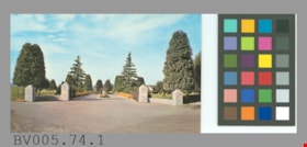
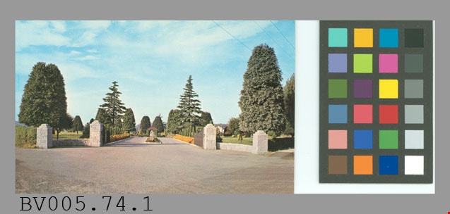
postcard
https://search.heritageburnaby.ca/link/museumartifact48902
- Repository
- Burnaby Village Museum
- Accession Code
- BV005.74.1
- Description
- Postcard, colour photo, glossy; horizontal; shows open gates at main entrance of cemetary, pillars, drive; trees, lawn, flowers visible beyond; on reverse in blue "OCEAN VIEW BURIAL PARK CO." "6790 Patterson Ave., S. Burnaby, B.C." "MAIN ENTRANCE" "Featuring some of the many pleasing floral displays which are established throughout the Cemetery. The entire Cemetery receives Endowed Care. Information supplied upon enquiry regarding prices of plots, cremation and mausoleum entombments."; at lower left, "Colour Photo by Dominion Photo Co., Vancouver, B.C."; up centre is "A Traveltime PRODUCT, MADE IN VANCOUVER, CANADA, BY GRANT-MANN LITHOGRAPHERS LTD."; at bottom, "C-478"; at upper right, "POST CARD" "ADDRESS", outline of rectangle "STAMP"; unused ; card is identical to BV005.74.2
- Object History
- This item was given to the donor when he was doing research for the Cemetery Tour, 2005.
- Classification
- Written Communication T&E - - Writing Media
- Object Term
- Postcard
- Marks/Labels
- Ocean View Burial Park Co. / 6790 Patterson Ave., S. Burnaby, BC / Main Entrance / featuring some of the many pleasing floral displays which are established throughout the cemetery
- Country Made
- Canada
- Province Made
- British Columbia
- Site/City Made
- Vancouver
- Title
- Ocean View Burial Park Co. C-478
- Names
- Dominion Photo Company
Images
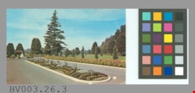
postcard
https://search.heritageburnaby.ca/link/museumartifact45451
- Repository
- Burnaby Village Museum
- Accession Code
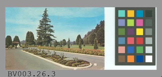
- BV003.26.3
- Description
- Postcard, colour photo, glossy; horizontal; shows drive with flowerbeds, shrubs, trees, lawn behind, fountain; in blue on reverse, "OCEAN VIEW BURIAL PARK" "6790 Patterson Ave., S. Burnaby, B.C." "FLOWER BED -- MAIN ENTRANCE" "One of the many beautiful and unusual floral effects which is a feature throughout the entire Cemetery grounds."; at bottom left, "Colour Photo by Dominion Photo Co., Vancouver, B.C."; up centre, "A Traveltime PRODUCT, MADE IN VANCOUVER, CANADA, BY GRANT-MANN LITHOGRAPHERS LTD."; at bottom, "C-480"; at upper right, "POST CARD" "ADDRESS", outline of rectangle "STAMP"; unused; smudges on address side; one corner creased
- Object History
- Purchased from E-Bay, #2163154620.
- Classification
- Written Communication T&E - - Writing Media
- Object Term
- Postcard
- Country Made
- Canada
- Province Made
- British Columbia
- Site/City Made
- Vancouver
- Title
- Ocean View Burial Park C-480
- Names
- Dominion Photo Company
Images
postcard
https://search.heritageburnaby.ca/link/museumartifact47196
- Repository
- Burnaby Village Museum
- Accession Code
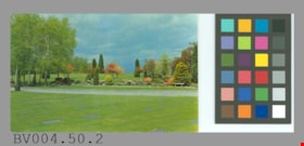
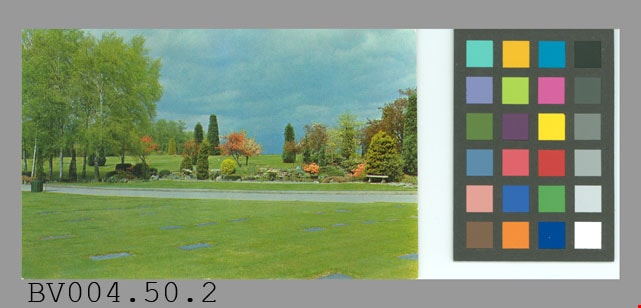
- BV004.50.2
- Description
- Postcard: colour photo, glossy; horizontal; Forest Lawn cemetery; shows lawn, markers, path, trees, shrubs, flowers; on reverse, "Famous for the beauty and unusual design of its magnificent gardens Forest Lawn Memorial Park attracts thousands of visitors every year. It is located on the Grandview Highway at Royal Oak Avenue, only a few miles from downtown Vancouver, B.C."; at lower left, "Colour Photo by Dominion Photo Co."; up centre "A Traveltime PRODUCT, MADE IN VANCOUVER, CANADA, BY GRANT-MANN LITHOGRAPHERS LTD."; maple leaf logo at top "BUY CANADIAN"; at bottom "C-744"; at upper right, "POST CARD" "ADDRESS", outline of rectangle "STAMP"; unused; slight wear on corners
- Classification
- Written Communication T&E - - Writing Media
- Object Term
- Postcard
- Marks/Labels
- Forest Lawn Memorial Park / Grandview Highway / Royal Oak Avenue
- Country Made
- Canada
- Province Made
- British Columbia
- Site/City Made
- Vancouver
- Title
- Forest Lawn Memorial Park C-744
- Names
- Dominion Photo Company
Images
postcard
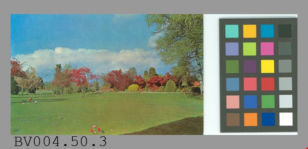
https://search.heritageburnaby.ca/link/museumartifact47197
- Repository
- Burnaby Village Museum
- Accession Code
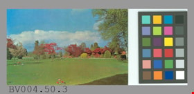
- BV004.50.3
- Description
- Postcard, colour photo, glossy; horizontal; shows Forest Lawn cemetery, lawn with some markers visible, shrubs and trees in background; on reverse in blue, "Famous for the beauty and unusual design of its magnificent gardens, Forest Lawn Memorial Park attracts thousands of visitors every year. It is located on the Grandview Highway at Royal Oak Avenue, only a few miles from downtown Vancouver, B.C."; at bottom left, "Colour Photo by Dominion Photo Co."; up centre, "A Traveltime PRODUCT, MADE IN VANCOUVER, CANADA, BY GRANT-MANN LITHOGRAPHERS LTD."; maple leaf logo at top "BUY CANADIAN"; at bottom, "C-747"; at upper right, "POST CARD", with "ADDRESS" below; outline of rectangle at upper right corner, "STAMP"; some yellowish stains; corners are worn; creasing at top centre and wear; unused
- Classification
- Written Communication T&E - - Writing Media
- Object Term
- Postcard
- Marks/Labels
- Forest Lawn Memorial Park / Grandview Highway / Royal Oak Avenue
- Country Made
- Canada
- Province Made
- British Columbia
- Site/City Made
- Vancouver
- Title
- Famous for the beauty... Forest Lawn Memorial Park... C-747
- Names
- Dominion Photo Company
Images
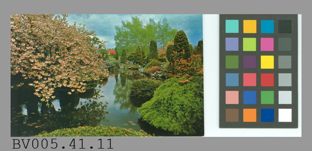
postcard
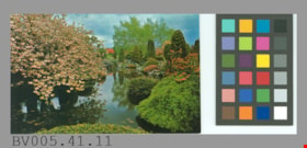
https://search.heritageburnaby.ca/link/museumartifact48617
- Repository
- Burnaby Village Museum
- Accession Code
- BV005.41.11
- Description
- Postcard: colour photo, glossy; horizontal; Forest Lawn cemetery; shows flowering tree and shrubs, trees around lake; on reverse in blue, "Famous for the beauty and design of its magnificent rock gardens and its lovely ornamental trees, Forest Lawn Memorial Park is located on the Grandview Highway at Royal Oak Avenue, Vancouver, B.C."; at bottom left, "Colour Photo by Dominion Photo Co."; up centre, "A Traveltime PRODUCT, MADE IN VANCOUVER, CANADA, BY GRANT-MANN LITHOGRAPHERS LTD."; maple leaf logo at top "BUY CANADIAN"; at bottom, "C-745"; at upper right, "POST CARD" "ADDRESS"; outline of rectangle "STAMP"; unused; very slight wear on corners
- Classification
- Written Communication T&E - - Writing Media
- Object Term
- Postcard
- Marks/Labels
- Forest Lawn / Memorial Park is located on the Grandview Highway at / Royal Oak Avenue, Vancouver, B.C. / C745
- Country Made
- Canada
- Province Made
- British Columbia
- Site/City Made
- Vancouver
- Title
- Forest Lawn Memorial Park C-745
- Names
- Dominion Photo Company
Images