Narrow Results By
Subject
- Adornment 83
- Adornment - Jewelry 4
- Adornment - Lapel Pins 83
- Advertising Medium 92
- Advertising Medium - Business Cards 17
- Advertising Medium - Flyer 34
- Advertising Medium - Poster 2
- Advertising Medium - Signs and Signboards 38
- Agricultural Tools and Equipment 5
- Agricultural Tools and Equipment - Cultivators 1
- Agricultural Tools and Equipment - Gardening Equipment 2
- Agriculture 3

Arrow Neon Sign
https://search.heritageburnaby.ca/link/landmark861
- Repository
- Burnaby Heritage Planning
- Description
- Commercial building.
- Associated Dates
- 1961
- Other Names
- Lost in the 50's Drive-in
- Street View URL
- Google Maps Street View
- Repository
- Burnaby Heritage Planning
- Other Names
- Lost in the 50's Drive-in
- Geographic Access
- Edmonds Street
- Associated Dates
- 1961
- Description
- Commercial building.
- Heritage Value
- The Arrow Neon Sign was built in 1961 by the Neonette Sign Company of New Westminster when this property was opened as the Tomahawk Drive-in Restaurant. The restaurant was later known as Lindy's Burger and in 1990, the business was renamed Lost in the 50's Drive-in. It stands 20-foot tall and is composed of a large double-sided hollow steel panel serpentine arrow mounted on a pole supporting a lexan sign panel measuring approximately 8 feet wide by 4 feet tall. The sign was designed with three illuminated features: a round lamp at the top of the pole, a double-sided rectangular fluorescent sign panel box, and two double-sided rows of orange neon arrows that follow the large serpentine arrow. The Arrow Neon Sign remains as a rare surviving example of neon sign art in the city and is the only historic neon sign in South Burnaby. The sign has gained prominence over the years as it has been associated with this small iconic drive-in which has also been utilized as a set for film production. Additionally, the drive-in has played a prominent role in the Edmonds community as a popular setting for recent "Show and Shine" participants to park their classic cars.
- Locality
- Edmonds
- Historic Neighbourhood
- East Burnaby (Historic Neighbourhood)
- Planning Study Area
- Lakeview-Mayfield Area
- Builder
- Neonette Sign Company
- Community
- Burnaby
- Contributing Resource
- Structure
- Ownership
- Public (local)
- Street Address
- 7741 Edmonds Street
- Street View URL
- Google Maps Street View
Images


Duncan & Margaret McGregor Estate 'Glen-Lyon' New Haven Barn
https://search.heritageburnaby.ca/link/landmark852
- Repository
- Burnaby Heritage Planning
- Description
- Designed in a vernacular architectural style, the New Haven Barn is a large gambrel-roofed barn located on the Edwardian era McGregor Estate 'Glen-Lyon,' overlooking the rich farmland of the Fraser River floodplain and near a ravine and forested area adjacent to Marine Drive in South Burnaby.
- Associated Dates
- 1939
- Formal Recognition
- Heritage Designation, Community Heritage Register
- Other Names
- Home of the Friendless, New Haven Borstal Home for Boys and Youthful Offenders, New Haven Correction Centre
- Street View URL
- Google Maps Street View
- Repository
- Burnaby Heritage Planning
- Other Names
- Home of the Friendless, New Haven Borstal Home for Boys and Youthful Offenders, New Haven Correction Centre
- Geographic Access
- Marine Drive
- Associated Dates
- 1939
- Formal Recognition
- Heritage Designation, Community Heritage Register
- Enactment Type
- Bylaw No. 12183
- Enactment Date
- 11/12/2006
- Description
- Designed in a vernacular architectural style, the New Haven Barn is a large gambrel-roofed barn located on the Edwardian era McGregor Estate 'Glen-Lyon,' overlooking the rich farmland of the Fraser River floodplain and near a ravine and forested area adjacent to Marine Drive in South Burnaby.
- Heritage Value
- The site is historically significant for its association with early social welfare and correctional reform. The estate was sold in 1926 to an inter-denominational religious organization called the Home of the Friendless, which used it as their B.C. headquarters. The organization was charged with several cases of abuse and neglect in 1937, after which a Royal Commission was formed that led to new legislation to regulate and license all private welfare institutions. 'Glen-Lyon' was sold to the provincial government, and was dedicated in 1939 by the Lt.-Gov. E.W. Hamber for use as the New Haven Borstal Home for Boys and Youthful Offenders (later renamed the New Haven Correction Centre). The Borstal movement originated in England in the late nineteenth century, as an alternative to sending young offenders and runaways to prisons by providing reformatories that focused on discipline and vocational skill. This site’s role as the first North American institution devoted to the Borstal School philosophy was historic, and influenced corrections programs across Canada. The New Haven Barn is a significant feature from its development in 1939 as the Borstal School, designed by Chief Provincial Architect Henry Whittaker of the Department of Public Works, and is the only remaining structure of its kind in Burnaby.
- Defining Elements
- Key elements that define the heritage character of the New Haven Barn include its: - gambrel-roofed barn with roof vent with finial, sliding hay loft and access doors, small multi-pane windows, and lapped wooden siding
- Historic Neighbourhood
- Fraser Arm (Historic Neighbourhood)
- Planning Study Area
- Big Bend Area
- Architect
- Henry Whittaker
- Function
- Primary Historic--Estate
- Community
- Burnaby
- Cadastral Identifier
- 003-004-661
- Boundaries
- 'Glen-Lyon' is comprised of a single residential lot located at 4250 Marine Drive, Burnaby.
- Area
- 230873.18
- Contributing Resource
- Building
- Ownership
- Private
- Names
- Whittaker, George
- New Haven Borstal Home for Boys and Youthful Offenders
- New Haven Correction Centre
- Borstal School
- Street Address
- 4250 Marine Drive
- Street View URL
- Google Maps Street View
Images


H.T. Ceperley Estate 'Fairacres' Greenhouse Foundation Wall
https://search.heritageburnaby.ca/link/landmark862
- Repository
- Burnaby Heritage Planning
- Description
- The original rubble stone walls that formed the foundation for a greenhouses adjacent to the Steam Plant Building provided heat to several greenhouses on the estate propoerty. The Root House, which is to the north of the Greenhouse Foundation Wall, provided storage for the farm operation.
- Associated Dates
- 1908
- Formal Recognition
- Heritage Designation, Community Heritage Register
- Repository
- Burnaby Heritage Planning
- Geographic Access
- Deer Lake Avenue
- Associated Dates
- 1908
- Formal Recognition
- Heritage Designation, Community Heritage Register
- Enactment Type
- Bylaw No. 140665
- Enactment Date
- 23/11/1992
- Description
- The original rubble stone walls that formed the foundation for a greenhouses adjacent to the Steam Plant Building provided heat to several greenhouses on the estate propoerty. The Root House, which is to the north of the Greenhouse Foundation Wall, provided storage for the farm operation.
- Heritage Value
- The outbuildings at 'Fairacres' are a rare surviving architecturally-designed ensemble of agricultural structures that exist in complementary harmony with the main estate house. Architect Robert Mackay Fripp (1858-1917), an outspoken advocate of Arts and Crafts design, was retained by the Ceperleys to design several original outbuildings on their estate, which was designed as a country estate with a working farm that included over 10 acres of productive berry and vegetable fields, with a large kitchen garden, a root house to store food, an orchard, and greenhouses heated by steam. The agricultural potential of the Deer Lake area made it one of the first parts of the municipality to attract settlement. In 1909, the Ceperleys built three large greenhouses heated by an adjacent steam plant (Fairacres Steam Plant). The greenhouses featured granite foundation walls, including this one which remains intact. The Ceperleys employed a large staff to manage the estate's agricultural production, including Chinese farm labourers. Produce was grown for use at the estate, and for sale at local markets. Agricultural use of the estate continued when a Catholic order of Benedictine monks purchased the estate as part of the Priory of St. Joseph and the Seminary of Christ the King, and continued to farm the land until 1953.
- Defining Elements
- Key elements that define the heritage character of the ‘Fairacres’ Steam Plant Building include its: - overall spatial arrangement of the Greenhouse Foundation Wall in relation to the Steam Plant Building and the Root House - original rubble stone walls reflecting the Arts and Crafts design aesthetic of the estate buildings.
- Locality
- Deer Lake Park
- Historic Neighbourhood
- Burnaby Lake (Historic Neighbourhood)
- Planning Study Area
- Douglas-Gilpin Area
- Architect
- Robert Mackay Fripp
- Function
- Primary Historic--Outbuilding
- Community
- Burnaby
- Cadastral Identifier
- P.I.D. No. 004-493-311 Legal Description: Block 3 Except: Part subdivided by Plan 26865, District Lot 79, Group 1, New Westminster District, Plan 536
- Boundaries
- ‘Fairacres’ is comprised of a single municipally-owned property located at 6344 Deer Lake Avenue, Burnaby.
- Area
- 17,065.00
- Contributing Resource
- Landscape Feature
- Remains
- Ownership
- Public (local)
- Other Collection
- Burnaby Historical Society, Community Archives: Ceperley Photograph Album
- Documentation
- Heritage Site Files: PC77000 20. City of Burnaby Planning and Building Department, 4949 Canada Way, Burnaby, B.C., V5G 1M2
- Street Address
- 6344 Deer Lake Avenue
Images


H.T. Ceperley Estate 'Fairacres' Root House
https://search.heritageburnaby.ca/link/landmark527
- Repository
- Burnaby Heritage Planning
- Description
- The ‘Fairacres’ Root House is a long, low one-storey masonry building, measuring 4.6 metres by 9.1 metres, with massively buttressed concrete walls and foundations. Built into sloping ground adjacent to the location of the former greenhouses, the surviving orchard and the kitchen entrance of the ma…
- Associated Dates
- 1908
- Formal Recognition
- Heritage Designation, Community Heritage Register
- Repository
- Burnaby Heritage Planning
- Geographic Access
- Deer Lake Avenue
- Associated Dates
- 1908
- Formal Recognition
- Heritage Designation, Community Heritage Register
- Enactment Type
- Bylaw No. 9807
- Enactment Date
- 23/11/1992
- Description
- The ‘Fairacres’ Root House is a long, low one-storey masonry building, measuring 4.6 metres by 9.1 metres, with massively buttressed concrete walls and foundations. Built into sloping ground adjacent to the location of the former greenhouses, the surviving orchard and the kitchen entrance of the main house, 'Fairacres,' this functional structure was used as a frost-free store for fruit and vegetables for the family's use.
- Heritage Value
- The outbuildings at 'Fairacres' are a rare surviving architecturally-designed ensemble of agricultural structures that exist in complementary harmony with the main estate house. Architect Robert Mackay Fripp (1858-1917), an outspoken advocate of Arts and Crafts design, was retained by the Ceperleys to design several original outbuildings on their estate. The Root House is important as a rare surviving, and exceptionally large, example of this building type in the Vancouver region. Unusual in the fact that an architect designed a building of such modest aspirations, it is also remarkable in its method of construction. The use of concrete as a structural material is one of the earliest in the region and extraordinary for its use on such a modest vernacular outbuilding; root cellars were typically built of loose stone. Built in 1908, the Root House was significantly altered in the 1960s and restored to its original design in 2000. The building is significant as an indicator of the market gardening activity in the area around Deer Lake and of the country-house self-sufficiency practiced by the Ceperley family. The Root House illustrates the cultural, aesthetic, and lifestyle values of the Ceperleys in constructing such a large building for storing their own produce.
- Defining Elements
- The outbuildings at 'Fairacres' are a rare surviving architecturally-designed ensemble of agricultural structures that exist in complementary harmony with the main estate house. Architect Robert Mackay Fripp (1858-1917), an outspoken advocate of Arts and Crafts design, was retained by the Ceperleys to design several original outbuildings on their estate. The Root House is important as a rare surviving, and exceptionally large, example of this building type in the Vancouver region. Unusual in the fact that an architect designed a building of such modest aspirations, it is also remarkable in its method of construction. The use of concrete as a structural material is one of the earliest in the region and extraordinary for its use on such a modest vernacular outbuilding; root cellars were typically built of loose stone. Built in 1908, the Root House was significantly altered in the 1960s and restored to its original design in 2000. The building is significant as an indicator of the market gardening activity in the area around Deer Lake and of the country-house self-sufficiency practiced by the Ceperley family. The Root House illustrates the cultural, aesthetic, and lifestyle values of the Ceperleys in constructing such a large building for storing their own produce.
- Locality
- Deer Lake Park
- Historic Neighbourhood
- Burnaby Lake (Historic Neighbourhood)
- Planning Study Area
- Douglas-Gilpin Area
- Architect
- Robert Mackay Fripp
- Function
- Primary Historic--Outbuilding
- Secondary Historic--Food Storage
- Community
- Burnaby
- Cadastral Identifier
- P.I.D. No. 004-493-311 Legal Description: Block 3 Except: Part subdivided by Plan 26865, District Lot 79, Group 1, New Westminster District, Plan 536
- Boundaries
- ‘Fairacres’ is comprised of a single municipally-owned property located at 6344 Deer Lake Avenue, Burnaby.
- Area
- 17,065.00
- Contributing Resource
- Building
- Landscape Feature
- Ownership
- Public (local)
- Other Collection
- Burnaby Historical Society, Community Archives: Ceperley Photograph Album
- Documentation
- Heritage Site Files: PC77000 20. City of Burnaby Planning and Building Department, 4949 Canada Way, Burnaby, B.C., V5G 1M2
- Street Address
- 6344 Deer Lake Avenue
Images


H.T. Ceperley Estate 'Fairacres' Steam Plant Building
https://search.heritageburnaby.ca/link/landmark528
- Repository
- Burnaby Heritage Planning
- Description
- Designed in the British Arts and Crafts style, the ‘Fairacres’ Steam Plant Buiding is a single-storey wood frame building with a gabled roof that originally housed the apparatus for climate control in the greenhouses, formerly located to its north. The original rubble stone walls that formed the fo…
- Associated Dates
- 1908
- Formal Recognition
- Heritage Designation, Community Heritage Register
- Repository
- Burnaby Heritage Planning
- Geographic Access
- Deer Lake Avenue
- Associated Dates
- 1908
- Formal Recognition
- Heritage Designation, Community Heritage Register
- Enactment Type
- Bylaw No. 9807
- Enactment Date
- 23/11/1992
- Description
- Designed in the British Arts and Crafts style, the ‘Fairacres’ Steam Plant Buiding is a single-storey wood frame building with a gabled roof that originally housed the apparatus for climate control in the greenhouses, formerly located to its north. The original rubble stone walls that formed the foundation for the greenhouses stand adjacent. The Steam Plant Building stands as a pendant to the Root House, which is to the north of the former greenhouses.
- Heritage Value
- The outbuildings at 'Fairacres' are a rare surviving architecturally-designed ensemble of agricultural structures that exist in complementary harmony with the main estate house. Architect Robert Mackay Fripp (1858-1917), an outspoken advocate of Arts and Crafts design, was retained by the Ceperleys to design several original outbuildings on their estate. The Ceperleys operated 'Fairacres' with staff, a farm manager and workers, including Chinese, to grow produce for themselves and for sale at local markets. The Steam Plant Building illustrates the market gardening activity of the area around Deer Lake and its importance to the Ceperley family, which valued a year-round supply of fresh fruit and vegetables for the kitchen and flowers for the house. It also illustrates the cultural and aesthetic values of the Ceperleys in retaining an architect to design a functional outbuilding using an accepted and contemporary architectural style. Built in 1908, the Steam Plant Building was significantly altered in the 1960s and restored to its original design in 2000.
- Defining Elements
- Key elements that define the heritage character of the ‘Fairacres’ Steam Plant Building include its: - overall spatial arrangement of the Steam Plant Building in relation to the former greenhouses and the Root House - side gable roof with cedar shingle cladding. - tall brick chimney indicitive of the building's original function. - distinctive Arts and Crafts architectural features such as the shingle wall cladding with decorative shingling under window sills, deep eaves, and pebble-dashed concrete foundation walls - six-paned wooden-sash casement windows - simple functional interior features - rubble stone walls that formed the foundation for the greenhouses
- Locality
- Deer Lake Park
- Historic Neighbourhood
- Burnaby Lake (Historic Neighbourhood)
- Planning Study Area
- Douglas-Gilpin Area
- Architect
- Robert Mackay Fripp
- Function
- Primary Historic--Outbuilding
- Community
- Burnaby
- Cadastral Identifier
- P.I.D. No. 004-493-311 Legal Description: Block 3 Except: Part subdivided by Plan 26865, District Lot 79, Group 1, New Westminster District, Plan 536
- Boundaries
- ‘Fairacres’ is comprised of a single municipally-owned property located at 6344 Deer Lake Avenue, Burnaby.
- Area
- 17,065.00
- Contributing Resource
- Building
- Landscape Feature
- Ownership
- Public (local)
- Other Collection
- Burnaby Historical Society, Community Archives: Ceperley Photograph Album
- Documentation
- Heritage Site Files: PC77000 20. City of Burnaby Planning and Building Department, 4949 Canada Way, Burnaby, B.C., V5G 1M2
- Street Address
- 6344 Deer Lake Avenue
Images

placemat
https://search.heritageburnaby.ca/link/museumartifact91017
- Repository
- Burnaby Village Museum
- Accession Code
- BV021.11.19
- Description
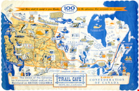
- placemat; paper promotional placemat with scalloped edges; coloured white, blue and yellow cartoon illustration map of Canada with British Columbia in yellow and oversized. At top: "and there shall be a pause to give thanks..100 YEARS..to the splendor that surrounds us..BC GOVERNMENT" and "TRAIL CAFE / HOPE, B.C., CANADA" at the centre bottom. "1866 The Union of the Colonies on Vancouver Island and on the Mainland as BRITISH COLUMBIA" and "1867 CONFEDERATION OF CANADA" Some folding at corners and brown stain over upper Pacific coast area.
- Object History
- Souvenir placemat was made available as a commemorative item in celebrating Confederation Centennial of British Columbia.
- Category
- 04.Tools & Equipment for Materials
- Classification
- Food Service T&E - - Food Service Accessories
- Object Term
- Placemat
- Marks/Labels
- "G.H. WOOD"; "Printed 1966 Canada"
- Measurements
- Length: 24.5 cm x Width: 37 cm
- Subjects
- Events
- Events - Anniversaries
- Advertising Medium
- Buildings - Commercial - Restaurants
- Food Service Tools and Equipment
Images
postcard
https://search.heritageburnaby.ca/link/museumartifact44832
- Repository
- Burnaby Village Museum
- Accession Code
- BV002.50.8
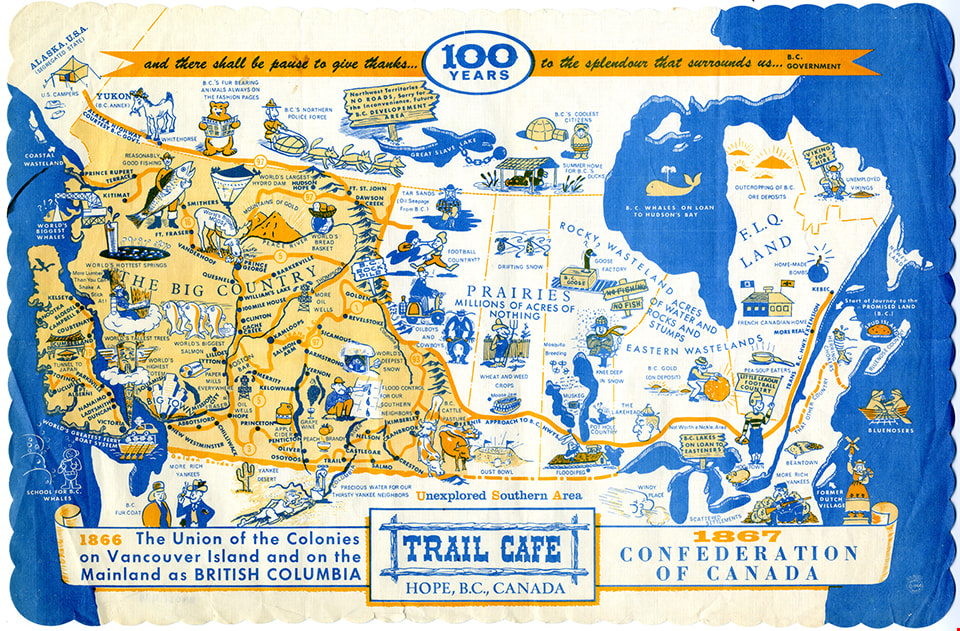
- Description
- Postcard: tinted photo; horizontal; shows single-storey white building with sign "GOLDEN DRAGON"; restaurant; large neon dragon sign at left, green car parked on street in front at left; glossy, white border; on reverse in black, "GOLDEN DRAGON" "3991 KINGSWAY" "BURNABY, B.C." "If you are not familiar with Chinese Foods let our Experts make suggestions and explain the traditions of eating that is famous throughout the world."; at bottom, "DINE and DANCE Every FRIDAY & SATURDAY"; line down centre; at right, "ADDRESS"; at upper right, "Place Stamp Here"; unused; some wear at corners; crease; scratches; print is heavy enough to be visible in places on front; ca.1950s
- Classification
- Written Communication T&E - - Writing Media
- Object Term
- Postcard
- Title
- Golden Dragon
- Subjects
- Persons - Chinese Canadians
- Documentary Artifacts
- Documentary Artifacts - Postcards
- Documentary Artifacts - Photographs
- Buildings
- Buildings - Commercial
- Buildings - Commercial - Restaurants
Images

postcard
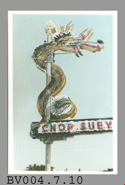
https://search.heritageburnaby.ca/link/museumartifact46525
- Repository
- Burnaby Village Museum
- Accession Code
- BV004.7.10
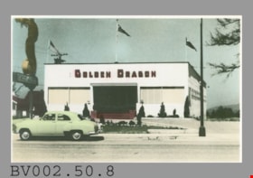
- Description
- Postcard: tinted colour photo; vertical; shows large neon dragon sign "Chop Suey"; glossy, white border, slightly wider at right; on reverse in black, "GOLDEN DRAGON" "3991 KINGSWAY" "BURNABY, B.C." "If you are not familiar with Chinese Foods let our Experts make suggestions and explain the traditions of eating that is famous throughout the world."; at bottom, "DINE and DANCE Every FRIDAY & SATURDAY"; line down centre; at right, "ADDRESS"; at upper right, "Place Stamp Here"; unused; some scratches; print is heavy enough to be visible on the front in places; ca. 1950s
- Object History
- Object purchased by BVM in 2004.
- Classification
- Written Communication T&E - - Writing Media
- Object Term
- Postcard
- Title
- Golden Dragon
- Subjects
- Documentary Artifacts
- Documentary Artifacts - Postcards
- Documentary Artifacts - Photographs
- Buildings
- Buildings - Commercial
- Buildings - Commercial - Restaurants
Images
postcard
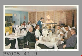
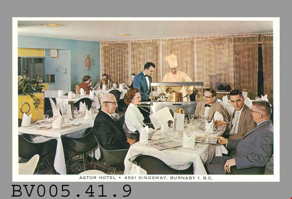
https://search.heritageburnaby.ca/link/museumartifact48615
- Repository
- Burnaby Village Museum
- Accession Code
- BV005.41.9
- Description
- Postcard: colour photo; horizontal; restaurant interior; white border, black print at bottom "ASTOR HOTEL. 4561 KINGSWAY, BURNABY 1, B.C."; shows people seated at table in dining room, waiter in background has meat carved by man in white with chef's hat at stainless steel serving station; on reverse in black, "THE HAIDA GRILL" "The delightful setting and excellent cuisine..."; aboriginal animal logo; "POST CARD"; line up centre, "CORRESPONDENCE" at left, "ADDRESS" at right; outline of rectangle at upper right, "Stamp Here"; pencilled "$7" at left; lightly soiled; c. 1950s; unused
- Classification
- Written Communication T&E - - Writing Media
- Object Term
- Postcard
- Marks/Labels
- Astor Hotel. 4561 Kingsway, Burnaby 1, B.C. / The Haida Grill / The delightful setting and excellent cuisine..
- Title
- Astor Hotel 4561 Kingsway, Burnaby 1, B.C.
- Subjects
- Documentary Artifacts
- Documentary Artifacts - Postcards
- Buildings
- Buildings - Commercial
- Buildings - Commercial - Hotels and Motels
- Buildings - Commercial - Restaurants
Images
postcard
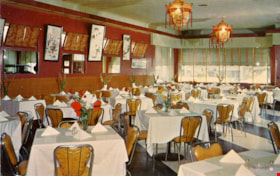
https://search.heritageburnaby.ca/link/museumartifact90986
- Repository
- Burnaby Village Museum
- Accession Code
- BV021.12.1
- Description
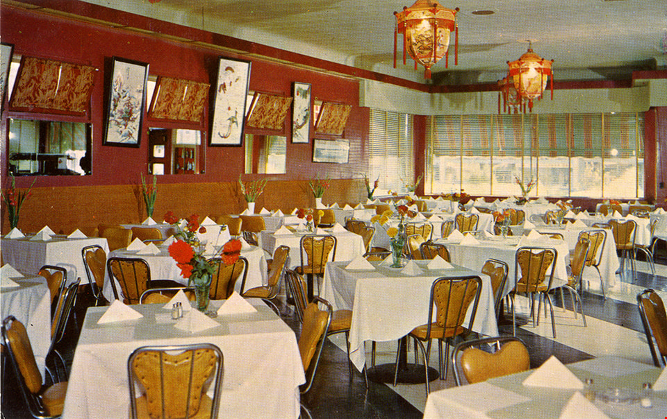
- Postcard: horizontal glossy colour postcard of Golden Dragon Resturant. Shows image of interior dining room with red and gold walls, laterns, tables with white table cloths. yellow chairs and a stripped black and white floor. On reservse in blue print: , "GOLDEN DRAGON" "3991 KINGSWAY" "BURNABY, B.C." "Phone: DExter 5100" "If you are not familiar with Chinese Foods let our Experts make suggestions and explain the traditions of eating that is famous throughout the world."; at bottom, "DINE and DANCE Every FRIDAY & SATURDAY"; line down centre; at right,"POST CARD" "ADDRESS"; at upper right, "STAMP"; unused; ca.1950s
- Object History
- Postcard from the Golden Dragon Resturant which served Chinese-Canadian food. Their grand opening was September 2, 1950. The community staple was known for its neon dragon sign that advertised “Chop Suey”. One side of the kitchen served Chinese foods, while another served Canadian dishes. Chinese cuisine such as rice would be served with chopsticks, while steaks, a more western dish, would be served with knife and fork. Advertisements from the resturant and meeting notices were found in local newspapers from 1950 to 1957. The establishment was not listed in the 1966 Great Vancouver Cross-Cross Directory.
- Classification
- Written Communication T&E - - Writing Media
- Object Term
- Postcard
- Marks/Labels
- Made in Canada by Grant-Mann Lithographers LTD. "Color Card" Division, Vancouver, British Columbia.
- Measurements
- 14cm wide x 9cm high
- Subjects
- Souvenirs
- Persons - Chinese Canadians
- Food Service Tools and Equipment
- Documentary Artifacts - Postcards
- Buildings - Commercial - Restaurants
- Historic Neighbourhood
- Central Park (Historic Neighbourhood)
- Planning Study Area
- Garden Village Area
Images
postcard; advertisement
https://search.heritageburnaby.ca/link/museumartifact44816
- Repository
- Burnaby Village Museum
- Accession Code
- BV002.48.8
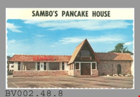
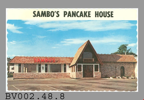
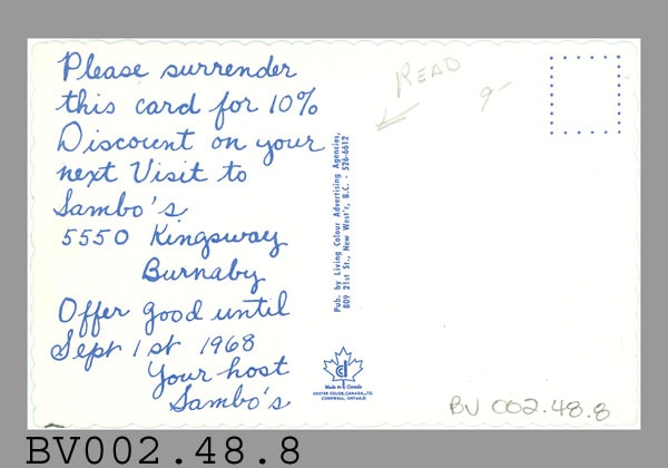
- Description
- Postcard, colour photo of single-storey building, brick and plaster, with projecting two-storey entrance, balcony over door, empty parking lot in foreground; red "SAMBO'S" on roof at left; blue sky with clouds; white border at top with black "SAMBO'S PANCAKE HOUSE"; scalloped edges; on reverse in blue up centre, "Pub. by Living Colour Advertising Agencies, 809 21st St., New West'r, B.C. - 526-6612; at bottom, maple leaf logo, "Made in Canada" "DEXTER COLOR, CANADA LTD." "CORNWALL, ONTARIO"; at left is preprinted handwritten message "Please surrender this card for 10% Discount on your next Visit to Sambo's 5550 Kingsway Burnaby Offer good until Sept 1st 1968 Your host Sambo's"; pencilled "READ" with arrow at top; pencilled "9-"; dotted outline of rectangle at upper right; glossy; unused
- Classification
- Written Communication T&E - - Writing Media
- Object Term
- Postcard
- Country Made
- Canada
- Province Made
- Ontario
- Site/City Made
- Cornwall
- Title
- Sambo's Pancake House
- Publication Date
- 1968.
- Subjects
- Documentary Artifacts
- Documentary Artifacts - Postcards
- Documentary Artifacts - Photographs
- Buildings
- Buildings - Commercial
- Buildings - Commercial - Restaurants
Images
postcard; advertisement
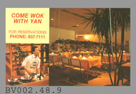
https://search.heritageburnaby.ca/link/museumartifact44817
- Repository
- Burnaby Village Museum
- Accession Code
- BV002.48.9
- Description
- Postcard: colour photos; horizontal; two; larger photo, at right, shows restaurant interior with palm trees; smaller photo at lower left of Stephen Yan wearing "COME WOK WITH YAN" apron; at upper left of card on yellow ground is red "COME WOK WITH YAN" "FOR RESERVATIONS PHONE: 937-7111"; on reverse in black at left is "9948 LOUGHEED HWY. BURNABY, B.C. CANADA V3J 1N3" "PHOTO BY COQUITLAM PHOTO", black line below, then simple map showing location of "YAN'S"; black line border at right [Yan owned two restaurants in the Vancouver area and his hit show, "Wok With Yan" was on the air from 1980-1995]; card appears to be c.1985; unused
- Classification
- Written Communication T&E - - Writing Media
- Object Term
- Postcard
- Title
- Come Wok With Yan
- Subjects
- Documentary Artifacts
- Documentary Artifacts - Postcards
- Documentary Artifacts - Photographs
- Buildings
- Buildings - Commercial
- Buildings - Commercial - Restaurants
Images

