Narrow Results By
Subject
- Advertising Medium - Signs and Signboards 2
- Building Components 1
- Buildings - Agricultural 4
- Buildings - Agricultural - Greenhouses 2
- Buildings - Agricultural - Stables 1
- Buildings - Civic 1
- Buildings - Civic - Community Centres 1
- Buildings - Civic - Museums 5
- Buildings - Commercial - Restaurants
- Buildings - Commercial - Stores 1
- Buildings - Heritage 16
- Buildings - Public - Detention Facilities 2
Arrow Neon Sign
https://search.heritageburnaby.ca/link/landmark861
- Repository
- Burnaby Heritage Planning
- Description
- Commercial building.
- Associated Dates
- 1961
- Other Names
- Lost in the 50's Drive-in
- Street View URL
- Google Maps Street View
- Repository
- Burnaby Heritage Planning
- Other Names
- Lost in the 50's Drive-in
- Geographic Access
- Edmonds Street
- Associated Dates
- 1961
- Description
- Commercial building.
- Heritage Value
- The Arrow Neon Sign was built in 1961 by the Neonette Sign Company of New Westminster when this property was opened as the Tomahawk Drive-in Restaurant. The restaurant was later known as Lindy's Burger and in 1990, the business was renamed Lost in the 50's Drive-in. It stands 20-foot tall and is composed of a large double-sided hollow steel panel serpentine arrow mounted on a pole supporting a lexan sign panel measuring approximately 8 feet wide by 4 feet tall. The sign was designed with three illuminated features: a round lamp at the top of the pole, a double-sided rectangular fluorescent sign panel box, and two double-sided rows of orange neon arrows that follow the large serpentine arrow. The Arrow Neon Sign remains as a rare surviving example of neon sign art in the city and is the only historic neon sign in South Burnaby. The sign has gained prominence over the years as it has been associated with this small iconic drive-in which has also been utilized as a set for film production. Additionally, the drive-in has played a prominent role in the Edmonds community as a popular setting for recent "Show and Shine" participants to park their classic cars.
- Locality
- Edmonds
- Historic Neighbourhood
- East Burnaby (Historic Neighbourhood)
- Planning Study Area
- Lakeview-Mayfield Area
- Builder
- Neonette Sign Company
- Community
- Burnaby
- Contributing Resource
- Structure
- Ownership
- Public (local)
- Street Address
- 7741 Edmonds Street
- Street View URL
- Google Maps Street View
Images
Capitol Hill School
https://search.heritageburnaby.ca/link/landmark564
- Repository
- Burnaby Heritage Planning
- Description
- School building.
- Associated Dates
- 1923
- Other Names
- Ecole Capitol Hill Elementary School
- Street View URL
- Google Maps Street View
- Repository
- Burnaby Heritage Planning
- Other Names
- Ecole Capitol Hill Elementary School
- Geographic Access
- Holdom Avenue
- Associated Dates
- 1923
- Description
- School building.
- Heritage Value
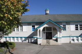
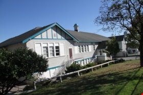
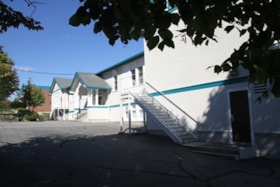
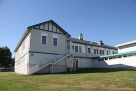
- This school was originally designed by Bowman & Cullerne as a two-storey, four-room school building in 1923, with a two-room addition completed in 1926 and another in 1927. Originally designed in the Arts and Crafts style, it has been altered, with the addition of stucco over the original siding and replacement windows, but has retained its original form and massing, as well as its roof-top ventilator and front gabled entrance with grouped columns. Bowman & Cullerne specialized in school design. After Harold Cullerne (1890-1976) returned from service during the First World War, he joined J.H. Bowman (1864-1943) in a partnership that lasted from 1919 to 1934. The firm’s other school designs included Seaforth School (1922, now relocated to Burnaby Village Museum), Burnaby North High School (1923), and Nelson Avenue School (1927).
- Locality
- Capitol Hill
- Historic Neighbourhood
- Capitol Hill (Historic Neighbourhood)
- Planning Study Area
- Capitol Hill Area
- Architect
- Bowman & Cullerne
- Ownership
- Public (local)
- Subjects
- Buildings - Heritage
- Buildings - Schools
- Street Address
- 350 Holdom Avenue
- Street View URL
- Google Maps Street View
Images
Douglas Road School
https://search.heritageburnaby.ca/link/landmark573
- Repository
- Burnaby Heritage Planning
- Description
- School building.
- Associated Dates
- 1928
- Other Names
- Douglas Road Elementary School
- Street View URL
- Google Maps Street View
- Repository
- Burnaby Heritage Planning
- Other Names
- Douglas Road Elementary School
- Geographic Access
- Canada Way
- Associated Dates
- 1928
- Description
- School building.
- Heritage Value
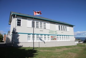
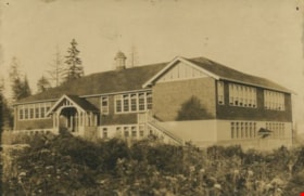
- The Douglas Road School was originally established as a two-room school in 1908 on this site, and later expanded to four classrooms. Anticipating rapid settlement of this district, the School Board purchased two acres adjoining the old building. Two of the four rooms were designed to become one large auditorium suitable for special events and public gatherings, with seating for two hundred people. The classically-influenced school has been altered with new windows and extended with additional wings, but has retained its original red-brick veneer, tan-brick quoins and bellcast octagonal roof ventilator. Designed by McCarter & Nairne, the school was built by contractor A.S. Perry. McCarter & Nairne, who also designed the Second Street School, were the Burnaby School Board architects at this time. John Y. McCarter (1886-1981) and George Nairne (1884-1953) formed their partnership in 1921 after serving overseas during the First World War. The partners began designing houses and small apartment buildings, and their commissions included Vancouver’s first skyscraper, the Marine Building (1928-30).
- Locality
- Burnaby Lake
- Historic Neighbourhood
- Burnaby Lake (Historic Neighbourhood)
- Planning Study Area
- Douglas-Gilpin Area
- Architect
- McCarter & Nairne
- Subjects
- Buildings - Heritage
- Buildings - Schools
- Street Address
- 4861 Canada Way
- Street View URL
- Google Maps Street View
Images
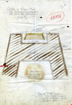
Detail of brass plates for monuments in connection with school sites in Burnaby
https://search.heritageburnaby.ca/link/museumdescription11919
- Repository
- Burnaby Village Museum
- Date
- March 6, 1915
- Collection/Fonds
- Ronald G. Scobbie collection
- Description Level
- Item
- Physical Description
- 1 architectural drawing : pencil and watercolour on blueprint paper ; 43.5 x 30 cm
- Scope and Content
- Item consists of a detail drawing titled "Detail of Brass Plates / for monuments in connection / with School sites, Burnaby - / Full Size”.
- Repository
- Burnaby Village Museum
- Collection/Fonds
- Ronald G. Scobbie collection
- Description Level
- Item
- Physical Description
- 1 architectural drawing : pencil and watercolour on blueprint paper ; 43.5 x 30 cm
- Scope and Content
- Item consists of a detail drawing titled "Detail of Brass Plates / for monuments in connection / with School sites, Burnaby - / Full Size”.
- Creator
- McGugan, Donald Johnston
- Subjects
- Buildings - Schools
- Responsibility
- Burnett & McGugan, Engineers and Surveyors
- Accession Code
- BV003.83.11
- Access Restriction
- No restrictions
- Reproduction Restriction
- No known restrictions
- Date
- March 6, 1915
- Media Type
- Architectural Drawing
- Scan Resolution
- 600
- Scan Date
- 15-Jan-2021
- Scale
- 100
- Notes
- Title based on contents of drawing
- Text on bottom right corner of drawing reads: "Burnett & McGugan / C.E. & B.C. Land Surveyors / New Westminster, BC / 6th March 1915"
- Red crayon marking on plan reads: "001819"
- verso of page is blue
Images
Monuments for school sites
https://search.heritageburnaby.ca/link/museumdescription11915
- Repository
- Burnaby Village Museum
- Date
- [1915]
- Collection/Fonds
- Ronald G. Scobbie collection
- Description Level
- Item
- Physical Description
- 1 architectural drawing : pencil on paper ; 27.5 x 21 cm
- Scope and Content
- Item consists of a drawing titled "Plans of Proposed concrete monuments for corners of / school sites for Burnaby School Board".
- Repository
- Burnaby Village Museum
- Collection/Fonds
- Ronald G. Scobbie collection
- Description Level
- Item
- Physical Description
- 1 architectural drawing : pencil on paper ; 27.5 x 21 cm
- Scope and Content
- Item consists of a drawing titled "Plans of Proposed concrete monuments for corners of / school sites for Burnaby School Board".
- Creator
- McGugan, Donald Johnston
- Subjects
- Buildings - Schools
- Accession Code
- BV003.83.10
- Access Restriction
- No restrictions
- Reproduction Restriction
- No known restrictions
- Date
- [1915]
- Media Type
- Architectural Drawing
- Scan Resolution
- 600
- Scale
- 100
- Notes
- Title based on contents of drawing
- Red crayon marking on plan reads: "001819"
Images
Proposed building addition for R. Raymer
https://search.heritageburnaby.ca/link/museumdescription15547
- Repository
- Burnaby Village Museum
- Date
- [1959]
- Collection/Fonds
- Roy Bernard Raymer fonds
- Description Level
- Item
- Physical Description
- 1 architectural drawing : blueline print ; 89.5 x 62 cm
- Scope and Content
- Item consists of a building plan titled "Proposed Building Addition for R. Raymer 6111 Kingsway Burnaby".This drawing pertains to the addition of a new kitchen and restaurant for the Oasis tea rooms located at 6105 Kingsway in Burnaby. Drawing includes a layout of the floor and side aspects of the …
- Repository
- Burnaby Village Museum
- Collection/Fonds
- Roy Bernard Raymer fonds
- Description Level
- Item
- Physical Description
- 1 architectural drawing : blueline print ; 89.5 x 62 cm
- Material Details
- Scale 1/2"=1'
- Scope and Content
- Item consists of a building plan titled "Proposed Building Addition for R. Raymer 6111 Kingsway Burnaby".This drawing pertains to the addition of a new kitchen and restaurant for the Oasis tea rooms located at 6105 Kingsway in Burnaby. Drawing includes a layout of the floor and side aspects of the building.
- Subjects
- Buildings - Commercial - Restaurants
- Names
- Raymer, Roy Bernard
- Oasis
- Geographic Access
- Kingsway
- Street Address
- 6111 Kingsway
- Accession Code
- HV977.121.7
- Access Restriction
- No restrictions
- Reproduction Restriction
- No known restrictions
- Date
- [1959]
- Media Type
- Architectural Drawing
- Planning Study Area
- Windsor Area
- Notes
- Title based on contents of architectural drawing
- Stamp of verso of drawing reads: "APR_29_1959"
- Note in blue ink on verso of drawing reads: "Raymur addition / 611 Kingsway"
Proposed building addition for R. Raymer
https://search.heritageburnaby.ca/link/museumdescription15548
- Repository
- Burnaby Village Museum
- Date
- [1959]
- Collection/Fonds
- Roy Bernard Raymer fonds
- Description Level
- Item
- Physical Description
- 1 architectural drawing : blueline print ; 89.5 x 62 cm
- Scope and Content
- Item consists of a building plan titled "Proposed Building Addition for R. Raymer 6111 Kingsway Burnaby". This drawing pertains to the addition of a new kitchen and restaurant for the Oasis tea rooms located at 6105 Kingsway in Burnaby. Drawing includes a layout of the floor and side aspects of the…
- Repository
- Burnaby Village Museum
- Collection/Fonds
- Roy Bernard Raymer fonds
- Description Level
- Item
- Physical Description
- 1 architectural drawing : blueline print ; 89.5 x 62 cm
- Material Details
- Scale 1/2"=1'
- Scope and Content
- Item consists of a building plan titled "Proposed Building Addition for R. Raymer 6111 Kingsway Burnaby". This drawing pertains to the addition of a new kitchen and restaurant for the Oasis tea rooms located at 6105 Kingsway in Burnaby. Drawing includes a layout of the floor and side aspects of the building.
- Subjects
- Buildings - Commercial - Restaurants
- Names
- Raymer, Roy Bernard
- Oasis
- Geographic Access
- Kingsway
- Street Address
- 6111 Kingsway
- 6105 Kingsway
- Accession Code
- HV977.121.6
- Access Restriction
- No restrictions
- Reproduction Restriction
- No known restrictions
- Date
- [1959]
- Media Type
- Architectural Drawing
- Planning Study Area
- Windsor Area
- Notes
- Title based on contents of architectural drawing
- Notes in blue ink on recto. of drawing read: "REFRIGERATOR INSTALLATION BY LESSEE. / PRESENT TWO TOILETS TO BE MAINTAINED / WITH OUTSIDE ACCESS TO COMMON / HALLWAY AS ON PLAN"



![Monuments for school sites, [1915] thumbnail](/media/hpo/_Data/_BVM_Cartographic_Material/2003/2003_0083_0010_001.jpg?width=280)